1. žĄú Ž°†
žĶúÍ∑ľ ÍłįŪõĄŽ≥ÄŪôĒ ŽįŹ žßÄÍĶ¨žė®ŽāúŪôĒŽ°ú žĚłŪēú ŪôėÍ≤Ĺ ŽįŹ žÉĚŪÉúÍ≥ĄžĚė Ž≥ÄŪôĒŽ°ú žó¨Ž¶Ąž≤† ÍįēžöįÍįēŽŹĄÍįÄ ŪĀ¨Í≤Ć ž¶ĚÍįÄŪēėÍ≥† žěąžúľŽ©į, ÍłČÍ≤©Ūēú ŽŹĄžčúŪôĒŽ°ú žĚłŪēú Ūēėž≤úž£ľŽ≥Ä ž£ľÍĪįžßÄ, ŽŹĄžč¨Í≥Ķžõź ŽďĪžĚė ŪôēžāįžúľŽ°ú Ūôćžąėž∑®žēĹžßÄžó≠žĚī ž¶ĚÍįÄŪēėžó¨ ŽŹĄžčúŪôćžąėŽ°ú žĚłŪēú ŽŹĄžč¨žßÄžĚė ŪĀį žĚłŽ™Ö ŽįŹ žě¨žāį ŪĒľŪēīÍįÄ ÍłČž¶ĚŪēėÍ≥† žěąŽč§. žč§ž†úŽ°ú Í≥ľÍĪį ‚Äė2002ŽÖĄ Ž£®žā¨‚Äô, ‚Äė2003ŽÖĄ Žß§ŽĮł‚Äô, ‚Äė2004ŽÖĄ ŽāėŽ¶¨‚Äô ŽďĪžĚė ŪÉúŪíćžúľŽ°ú žĚłŪēī žßĎž§ĎŪėłžöįŽ°ú žĚłŪēú ŪôćžąėŽ°ú ŽßéžĚÄ ŪĒľŪēīÍįÄ žěąžóąŽč§. žĚīžôÄ ÍįôžĚī Žß§ŽÖĄ ŽįėŽ≥ĶŽźėŽäĒ Ūôćžąė žě¨ŪēīŽ°úŽ∂ÄŪĄį ÍĶ≠ŽĮľžĚė žÉĚŽ™ÖÍ≥ľ žě¨žāįžĚĄ Ž≥īŪėłŪēėÍ≥† žě¨ŪēīžĚė Ūö®Í≥ľž†ĀžĚł ÍīÄŽ¶¨Ž•ľ žúĄŪēīžĄú žā¨ž†Ąžėąžł°žĚĄ žúĄŪēú Ž∂ĄžĄĚžčúžä§ŪÖú ÍĶ¨ž∂ēžĚī ŪēĄžöĒŪēėŽāė ŽĆÄŽ∂ÄŽ∂ĄžĚė žě¨ŪēīžóźŽäĒ ŽßéžĚÄ Ž≥ÄžąėžôÄ Ž∂ąŪôēžč§žĄĪžĚī ž°īžě¨Ūēėžó¨ ŪėĄžě¨žĚė ž†ēŽ≥īž≤īÍ≥ĄžóźžĄúŽäĒ ŪēúÍ≥ĄÍįÄ žěąŽč§(Yun et al., 2010).
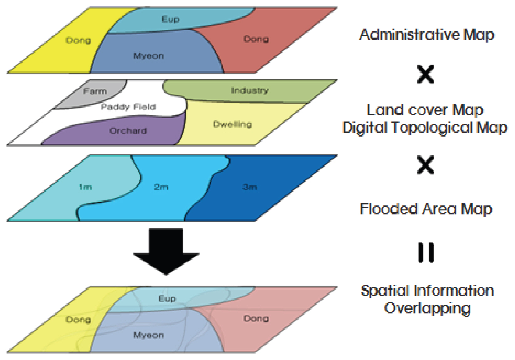
ŽĒįŽĚľžĄú, ŪôćžąėŽ≤ĒŽěĆÍ≥ľ žĻ®žąėŽ∂ĄžĄĚ ŽďĪ žąėŽ¶¨Ūēôž†Ā Ž¨łž†úŽď§žĚÄ Žč§žĖĎŪēėÍ≥† Ž≥Ķžě°Ūēú žßÄŪėēžĚĄ Ž∂ĄžĄĚŪēėÍ≥† ŪĚźŽ¶Ą žėąžł°ŪēėŽäĒ Í≤ÉžĚī ŪēĄžöĒŪēėŽ©į žąėžĻėŪēīžĄĚŪĒĄŽ°úÍ∑łŽě®, Í≤ĹŪóėžčĚ ŽďĪ Žč§žĖĎŪēú Žį©Ž≤ēžĚĄ ŪÜĶŪēėžó¨ žßÄžÜ枆ĀžúľŽ°ú žóįÍĶ¨ŽźėÍ≥† žěąŽč§.
Yeo (2003)žĚÄ žĻėžąėÍ≤Ĺž†úžĄĪŽ∂ĄžĄĚ ž†ąžį® ž§ĎžóźžĄú ŪéłžĚĶžĚł žėąžÉĀžóįŪŹČÍ∑†ŪĒľŪēīžē°žĚĄ ÍĶ¨ŪēėÍłį žúĄŪēėžó¨ ŽĻąŽŹĄŽ≥Ą žėąžÉĀžĻ®žąėŽ©īž†Āžóź ŽĆÄŪēú ŪĒľŪēīžē°žĚĄ žāįž†ēŪēėŽäĒ žč̞̥ žóįÍĶ¨ŪēėžėÄžúľŽ©į žč§ž†ú ŪĒľŪēīŽ•ľ žěÖžĚÄ žĻ®žąėŽ©īž†Āžóź ŽĒįŽ•ł ŪĒľŪēīžē°žĚė žěźŽ£ĆŽ•ľ žąėžßĎŪēėžó¨ ÍīÄÍ≥Ąžč̞̥ ŽŹĄž∂úŪēėžėÄŽč§. Choi et al. (2004)žĚÄ ÍĶ≠ŽāīžóźžĄú žā¨žö©ž§ĎžĚł žĻėžąėÍ≤Ĺž†úžĄĪŽ∂ĄžĄĚžĚė Ž¨łž†úž†źžóź ŽĆÄŪēú ÍįúžĄ†Žį©žēąžúľŽ°ú Žč§žį®žõźŽ≤ēžĚĄ ÍįúŽįúŪēėžėÄŽč§. Lee et al. (2006)žĚÄ Žč§žį®žõźŽ≤ēžĚĄ žĚīžö©Ūēėžó¨ ŽŹĄžčúžßÄžó≠žóź ž†ĀŪē©ŪēėŽŹĄŽ°Ě Žč§žį®žõźŽ≤ēžĚė ŪôćžąėŪĒľŪēīžāįž†ē žöĒžÜƎ吏̥ Ž≥īž†ēŪēėžó¨ ŽŹĄŽ¶ľž≤úžú†žó≠žóź ž†Āžö©Ūēėžó¨ Ž∂ĄžĄĚžĚĄ žč§žčúŪēėžėÄŽč§. Lee and Park (2011)žĚÄ Íłįž°ī žĻ®žąėžúĄŪóėŽŹĄ žóįÍĶ¨žĚė ŪēúÍ≥ĄŽ•ľ ÍįúžĄ†ŪēėÍ≥†žěź ŪēėžėÄžúľŽ©į ÍłąÍįē žĚľŽ∂Ä ÍĶ¨ÍįĄžóź žąėžĻėžßÄŪėēŽŹĄ ŽįŹ Ū܆žßÄŪĒľŽ≥ĶŽŹĄŽ•ľ ÍłįžīąŽ°ú MD-FDA Žį©Ž≤ēžĚĄ ÍĶ¨ŪėĄŪēėÍłį žúĄŪēú Žį©Ž≤ēŽ°†žĚĄ ÍįúŽįúŪēėžėÄŽč§. Lee (2011)žĚÄ ŽĮłŽěė ÍłįŪõĄŽ≥ÄŪôĒžóź žĚėŪēú ŪôēŽ•†ÍįēžöįŽüČžóź ŽĆÄŪēú žėąžÉĀŪôćžąėŪĒľŪēīžē°žĚĄ ŽĻĄÍĶźŪēėÍ≥†žěź ŪēėžėÄžúľŽ©į ÍłįŪõĄŽ≥ÄŪôĒžóź ŽĆÄŽĻĄŪēėžėĞ̥ ŽēĆžĚė ŪéłžĚĶžĚĄ ž†ēŽüČž†ĀžúľŽ°ú ŽĻĄÍĶźŪēėÍ≥†žěź ŪēėžėÄŽč§. Park et al. (2015)ŽäĒ GISžěźŽ£ĆŽ•ľ ÍłįŽįėžúľŽ°ú Multi-Dimensional Flood Damage Analysis (MD-FDA) ŪŹČÍįÄŪē≠Ž™©Ž≥Ą Ž∂ĄžĄĚžĚĄ ŪÜĶŪēī ÍĶ¨Ž¶¨žčúžĚė Ūôćžąėž∑®žēĹŪäĻžĄĪžĚĄ ŪŹČÍįÄŪēėžėÄŽč§. Tak et al. (2017)žĚÄ Storm & Wastewater Management Model (XP-SWMM)Ž™®ŪėēžĚĄ žĚīžö©Ūēėžó¨ žĻ®žąėžßÄžó≠Žāī ŪĒľŪēīžē° žāįž†ēžĚĄ žúĄŪēī žĄłŽ∂Ä ÍĪīŽ¨ľŪėēŪÉú ŽįŹ Žāīžö©Ž¨ľžĚĄ Í≥†Ž†§ŪēėŽäĒ Žč§žį®žõźŪôćžąėŪĒľŪēīžāįž†ēŽį©Ž≤ēžĚė ŽŹĄžčúžßÄžó≠Žāī ž†Āžö©žĄĪžĚĄ Í≤ÄŪ܆ŪēėžėÄŽč§.
Dutta and Herath (1998)žĚÄ žěźžāįÍįÄžĻėŽ•ľ ž°įžā¨Ūēú žěźŽ£ĆžôÄ ŪôćžąėŽ≤ĒŽěĆŽ™®ŪėēžĚĄ GISžôÄ žóįÍ≥ĄŪēú Flood Damage Assessment (FDA) MethodologyŽ•ľ ÍįúŽįúŪēėžėÄŽč§. Tate (1999)ŽäĒ HEC-RASžôÄ ArcViewŽ•ľ žĚīžö©Ūēėžó¨ žĻ®žąėŪĚĒž†ĀŽŹĄŽ•ľ žěĎžĄĪŪēėžėÄžúľŽ©į Snead and Maidment (2000)ŽäĒ HEC-GeoRASŽ•ľ žĚīžö©Ūēėžó¨ ŪôćžąėŪĄį ÍįÄžčúŪôĒžóįÍĶ¨Ž•ľ ŪēėžėÄŽč§. žĚľŽ≥ł ÍĪīžĄ§žĄĪ(MLIT, 2000)žóźžĄúŽäĒ Íłįž°īžĚė ‚ÄúžĻėžąėÍ≤Ĺž†úž°įžā¨žöĒÍįē‚ÄĚžĚė Žį©Ž≤ēžĚĄ Ž≥īžôĄ ŽįŹ Žįúž†Ąžčúžľú ‚ÄúžĻėžąėÍ≤Ĺž†úž°įžā¨Ž©ĒŽČīžĖľ‚Ä̞̥ ŽįúÍįĄŪēėžėÄŽč§. Biza et al. (2001)žĚÄ žěźžāįž†ēŽ≥ī, Í≤Ĺž†úž†Ā žěźŽ£Ć, žąėŽ¨łžěźŽ£Ć ŽďĪžĚĄ GISžôÄ žóįÍ≥ĄŪēú Flood Analysis Toolbox (FAT) ŪôćžąėŪĒľŪēī žāįž†ēŽ™®ŪėēžĚĄ ÍįúŽįúŪēėžėÄŽč§. Beffa and Connell (2001)žĚÄ 2žį®žõź Ž≤ĒŽěĆŽ™®ŪėēžĚł Hydro2de Ž™®ŪėēžĚĄ ÍįúŽįúŪēėžó¨ ž†úŽāīžßÄžĚė žßÄŪėēŪäĻžĄĪÍ≥ľ Í≤©žěźžÉĚžĄĪž°įÍĪīžóź ŽĆÄŪēī Í≤ÄŪ܆ŪēėžėÄžúľŽ©į Waihao ÍįēžĚė ŪôćžąėŪĄįžóź ž†Āžö©Ūēėžó¨ žēąž†ēžĄĪ ŽįŹ ž†ēŪôēžĄĪžĚĄ Ž∂ĄžĄĚŪēėžėÄŽč§.
Ž≥ł žóįÍĶ¨žóźžĄúŽäĒ ŽĆÄžÉĀžú†žó≠žúľŽ°ú ŽŹĄžč¨žĚĄ ÍīÄŪÜĶŪēėžó¨ ŪĚźŽ•īŽäĒ ŽŹĄžčúŪēėž≤úžĚł žõźž£ľž≤ú žú†žó≠žúľŽ°ú žĄ†ž†ēŪēėžėÄžúľŽ©į ŪôćžąėŽ≤ĒŽěĆŽ™®ŪėēžĚł Flo-2DŽ™®ŪėēžĚĄ žĚīžö©Ūēėžó¨ ŽĻąŽŹĄŽ≥Ą(50ŽÖĄ, 80ŽÖĄ, 100ŽÖĄ, 200ŽÖĄ) ŪôćžąėŪĒľŪēīŽ©īž†ĀžĚĄ žāįž†ēŪēėžėÄŽč§. Žč§žį®žõźŽ≤ēžĚĄ žĚīžö©Ūēėžó¨ ŪôćžąėŪĒľŪēīžē°žĚĄ žāįž†ēŪēėžėÄžúľŽ©į žĚľŽįėž†ĀžúľŽ°ú žā¨žö©ŪēėŽäĒ Ž©īž†ĀŽĻĄŽ•ľ žĚīžö©Ūēú ŪéłžěÖŽ•† žāįž†ēŽį©Ž≤ēÍ≥ľ žč§ž†ú ÍĪīŽ¨ľÍĶį žěźŽ£ĆŽ•ľ žĚīžö©Ūēú ŪéłžěÖŽ•† žāįž†ēŽį©Ž≤ēžĚė ŪôćžąėŪĒľŪēīžē° ŽĻĄÍĶźŽ•ľ ŪēėžėÄŽč§. ÍĪīŽ¨ľÍĶį žĚłŽ≤§Ū܆Ž¶¨žĚė Í≤Ĺžöį Ž™®Žď† ÍĪīŽ¨ľ žö©ŽŹĄžóź ŽĆÄŪēú žěźŽ£ĆÍįÄ Ž∂Äž°ĪŪēėžó¨ Ū܆žßÄžĚīžö©ŽŹĄžôÄ ž§Ďž≤©ŽźėŽäĒ Ž∂ÄŽ∂Ąžóź ŽĆÄŪēėžó¨ ÍĪīŽ¨ľ žö©ŽŹĄŽ•ľ žĄ†ž†ēŪēėžėÄŽč§. ŽėźŪēú Í≥ĶÍ≥ĶžčúžĄ§Ž¨ľ ŪĒľŪēīžē° žāįž†ēžčú žě¨ŪēīžóįŽ≥īžóźžĄú ž†úžčúŽźú Í≥ĶÍ≥ĶžčúžĄ§Ž¨ľ ŪĒľŪēīžē° ŽĻĄžú®Í≥ľ žĚľŽ≥łÍĪīžĄ§žĄĪžóźžĄú ž†úžčúŽźú Í≥ĶÍ≥ĶžčúžĄ§Ž¨ľ ŪĒľŪēīžē° ŽĻĄžú®žĚĄ ž†Āžö©ŪēėžėĞ̥ ŽēĆžĚė ŪĒľŪēīžē° žį®žĚīžóź ŽĆÄŪēīžĄúŽŹĄ ŽĻĄÍĶźŪēėÍ≥†žěź ŪēėžėÄŽč§.
Fig. 1žĚÄ Ž≥ł žóįÍĶ¨žĚė ŪĚźŽ¶ĄŽŹĄžĚīŽč§.
2. žĚīŽ°†ž†Ā ŽįįÍ≤Ĺ
2.1 Žč§žį®žõźŪôćžąėŪĒľŪēī žāįž†ēŽį©Ž≤ē
žĻėžąėžā¨žóÖžĚė Í≤Ĺž†úžĄĪ Ž∂ĄžĄĚžĚÄ žā¨žóÖ ž†ĄžĚÄ Ž¨ľŽ°† žā¨žóÖ ŪõĄžóźŽŹĄ ŪéłžĚĶžĚė žč§ž≤īÍįÄ žôĄŽ≤ĹŪěą Í≤Äž¶ĚŽźėÍłį žČĹžßÄ žēäžúľŽĮÄŽ°ú ŪôćžąėŪĒľŪēīžóź ŽĆÄŪēú žėąžł°žĚÄ žā¨žóÖžĚė ž∂ĒžßĄžóź žěąžĖī ž§ĎžöĒŪēú Ž∂ÄŽ∂ĄžĚīÍ≥† Žß§žöį ŽĮľÍįźŪēú žā¨žēąžĚīŽč§. ŽĒįŽĚľžĄú žč†ŽĘįŪē† ŽßĆŪēú ŪôćžąėŪĒľŪēī žāįž†ēžĚĄ žúĄŪēīžĄúŽäĒ Í≥ĶŪēôž†Ā žł°Ž©īÍ≥ľ Í≤Ĺž†úž†Ā žł°Ž©īžĚī Ž™®ŽĎź Í≥†Ž†§ŽźėžĖīžēľ ŪēėÍłį ŽēĆŽ¨łžóź žĚīžóź ŽĆÄŪēú Ž∂ĄžĄĚÍ≥ľ ž°įžā¨žĚė Ž≤ĒžúĄÍįÄ Žß§žöį ŽĄďŽč§. Í≥ĶŪēôž†Ā žł°Ž©īžóźžĄúŽäĒ ž£ľŽ°ú žąėŽ¶¨‚čÖžąėŽ¨łŪēôž†Ā Ž∂ĄžĄĚžóź žĚėŪēú Ž≤ĒŽěĆŽ™®žĚėžôÄ ž†úŽāīžßÄ žĻ®žąėžėąžł°žĚĄ žč§žčúŪēėÍ≤Ć ŽźėŽäĒŽćį žĚīŽäĒ ŪôćžąėŪĒľŪēī žāįž†ēžĚÄ Ž¨ľŽ°†žĚīÍ≥† žĻėžąėÍ≥ĄŪöć ž†ĄŽįėžóź ŪēĄžąėž†ĀžĚīÍ≥† ÍįÄžě• ÍłįŽ≥łž†ĀžĚł Í≥ľž†ēžĚīŽč§. Í≤Ĺž†úž†Ā žł°Ž©īžĚÄ žėąžł°Žźú žĻ®žąėÍĶ¨žó≠ ŽāīžĚė Í≤Ĺž†úž†Ā ÍįÄžĻėŽ•ľ ŽĆÄŽ≥ÄŪē† žąė žěąŽäĒ ÍįĀžĘÖ žěźŽ£ĆžôÄ žßÄŪĎúŽď§žĚĄ ž°įžā¨Ūēėžó¨ ŪôćžąėŪĒľŪēīŽ°ú Í≥ĄŽüČŪôĒŪēėŽäĒ ÍįÄž†ēžĚīŽč§(Yi, 2007).
2.2 žĻ®žąėŪéłžěÖŽ•† žāįž†ēŽį©Ž≤ē
žĻ®žąėŪéłžěÖŽ•†žĚīŽěÄ ŪĖČž†ēÍĶ¨žó≠ ŽāīžóźžĄú ž£ľÍĪį, žāįžóÖ, ŽÜćžóÖ ŽďĪ žßÄžó≠ŪäĻžĄĪžöĒžÜĆžĚė žīĚžěźžāįÍįÄžĻėŽ•ľ žč§ž†ú žĻ®žąėŽźú Ž∂ÄŽ∂Ąžóź ŽĆÄŪēú žěźžāįÍįÄžĻėŽ°ú ŪôėžāįŪēėÍłį žúĄŪēī žßÄžó≠ŪäĻžĄĪžöĒžÜĆŽ≥ĄŽ°ú žßÄŽ¶¨žöĒžÜƞ̳ Í≥ĶÍįĄÍįĚž≤īŽď§žĚė žúĄžĻėž†ēŽ≥īŽ•ľ žĻ®žąėžč¨Ž≥ĄŽ°ú ž§Ďž≤©Ūēėžó¨ ž†Ąž≤īžóź ŽĆÄŪēú ŽĻĄžú®Ž°ú ŽāėŪÉÄŽāł Í≤ÉžĚīŽč§. ŽĒįŽĚľžĄú žĻ®žąėŪéłžěÖŽ•†žĚÄ ŪĖČž†ēÍĶ¨žó≠Ž≥ĄŽ°ú žāįž†ēŽźėŽ©į ž£ľÍĪį, žāįžóÖ, ŽÜćžóÖžĚė žĄł ÍįÄžßÄ žßÄžó≠ŪäĻžĄĪžöĒžÜƎ吏Ěī ÍįĀÍįĀ ŪéłžěÖŽźėŽäĒ žĻ®žąėžč¨Ž≥ĄŽ°ú žāįž†ēŽźėÍ≥† žĻ®žąėžč¨Ž≥Ą ŪéłžěÖŽ•†žĚė Ūē©žĚÄ žĖłž†úŽāė 1žĚī ŽźúŽč§. Fig. 2ŽäĒ žĻ®žąėŪéłžěÖŽ•†žĚĄ žāįž†ēŪēėÍłį žúĄŪēėžó¨ Í≥ĶÍįĄž†ēŽ≥īŽ•ľ ž§Ďž≤©ŪēėŽäĒ ÍįúŽÖź(KDI, 2008)žĚĄ ŽāėŪÉÄŽāīÍ≥† žěąŽč§.
2.3 Í≥ĶÍ≥ĶžčúžĄ§Ž¨ľŪĒľŪēīžē° žāįž†ēŽį©Ž≤ē
Í≥ĶÍ≥ĶžčúžĄ§Ž¨ľžĚė ŪĒľŪēīžē°žĚÄ Í∑ł Ž≤ĒžúĄžôÄ Í∑úŽ™®Ž°ú Ž≥ľ ŽēĆ, žßĀž†Ďž†ĀžĚł Žį©Ž≤ēžúľŽ°úŽäĒ žāįž†ēžĚī ÍĪįžĚė Ž∂ąÍįÄŽä•ŪēėŽč§. ŽĒįŽĚľžĄú žĚľŽįėžěźžāįŪĒľŪēīžē°žóź ŽĆÄŪēú Í≥ĶÍ≥Ķ Ū܆Ž™©žčúžĄ§žĚė ŪĒľŪēīžē° ŽĻĄžú®žĚĄ žā¨žö©ŪēėŽäĒ Í≤ÉžĚī žĚľŽįėž†ĀžĚīŽč§. Table 2ŽäĒ KDI (2008)žóźžĄú ž†úžčúŪēėÍ≥† žěąŽäĒ žĚľŽ≥ł ÍĶ≠Ū܆ÍĪīžĄ§žĄĪ Í≥ĶÍ≥ĶžčúžĄ§Ž¨ľ ŪĒľŪēīžē°ŽĻĄžú®žĚĄ ŽāėŪÉÄŽāīÍ≥† žěąŽč§.
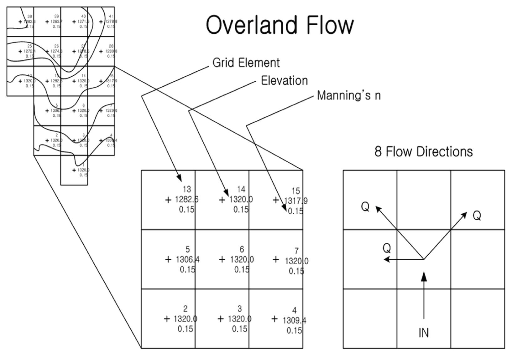
2.4 ŪôćžąėŽ≤ĒŽěĆŽ™®Ūėē Flo-2D
Flo-2DŽ™®ŪėēžĚÄ 1988ŽÖĄ ŽĮłÍĶ≠ žĹúŽ°úŽĚľŽŹĄ ž£ľžĚė Ž≥īŪóėžö© ŽŹĄžčú žĻ®žąėÍįÄŽä•žßÄžó≠žĚĄ ŪĆĆžēÖŪēėÍłį žúĄŪēėžó¨ žóįŽį©ŽĻĄžÉĀ ÍīÄŽ¶¨ÍĶ≠(FEMA)žóźžĄú ÍįúŽįúŽźėžóąžúľŽ©į Í≥ĶžĚłŽźú Ž™®ŪėēžĚīŽĚľ žč†ŽĘįžĄĪžĚī ŽÜíŽč§. Flo-2D Ž™®ŪėēžĚė žčúžä§ŪÖúžĚÄ Í∑łŽěėŪĒĹ ŪéłžßĎÍ≥ľ ŽßĶŪēϞ̥ žúĄŪēú ŪĒĄŽ°úžĄłžĄúžôÄ žąėŽ°úžôÄ Ž≤ĒŽěĆžõźžĚĄ žÉĀžĄłŪěą žčúŽģ¨Ž†ąžĚīžÖė Ūē† žąė žěąŽäĒ žöĒžÜĆŽ°ú ÍĶ¨žĄĪŽźúŽč§. Grid Developer System (GDS)žĚÄ žóįžÜ掟ú žěĎžĚÄ ŪÉĞ̾Ž°ú žßÄŪėēžĚĄ ŽĆÄžč†Ūē† Í≤©žěźŽß̞̥ žÉĚžĄĪŪēúŽč§. Flo-2DŽ™®ŪėēžĚÄ Íįēžöį, žąėŽ°úžóźžĄúžĚė ŪĚźŽ¶Ą, ŽŹĄŽ°úžóźžĄúžĚė ŪĚźŽ¶Ą, žĻ®Ūą¨, ž†úŽį© ŽďĪ Ž¨ľŽ¶¨ž†Ā ŪäĻžĄĪ ŽďĪžĚė ÍĶ¨žĄĪžöĒžÜĆŽ•ľ ÍįĞߥŽč§. PROFILES ŪĒĄŽ°úÍ∑łŽě®žĚÄ žąėŽ°úžĚė Í≤Ĺžā¨ ŽįŹ Žč®Ž©īŪėēžÉĀžĚĄ ŪéłžßĎŪēėŽ©į Ūôćžąė Í≤ĹŽ°úžĚė Í≤įÍ≥ľŽäĒ MAXPLOT, MAPPER, HYDRO ŪĒĄŽ°úÍ∑łŽě®žúľŽ°ú Í∑łŽěėŪĒĹž†ĀžúľŽ°ú ŪôēžĚł Ūē† žąė žěąŽč§. Fig. 3žĚÄ ŪĚźŽ¶ĄŽį©ž†ēžč̞̥ ŽŹĄžčĚŪôĒ Ūēú Í∑łŽ¶ľžĚīŽč§. Flo-2DžĚė ŪĚźŽ¶ĄŽį©ž†ēžčĚžĚÄ Eq. (1)Í≥ľ ÍįôžúľŽ©į, žóįžÜćŽį©ž†ēžčĚÍ≥ľ žöīŽŹôŽüČŽį©ž†ēžč̞̥ ÍłįŽ≥łžúľŽ°ú ŪēúŽč§.
žó¨ÍłįžĄú hŽäĒ žú†ŽüČžĚė ÍĻäžĚī, VŽäĒ žčúžěĎÍ≤©žěźžóźžĄú 8Žį©ŪĖ• ŪĚźŽ¶Ą(xŽį©ŪĖ•) ž§Ď ŪēėŽāėžĚė ŪŹČÍ∑†žú†žÜćžĚīŽ©į, iŽäĒ žīąÍ≥ľÍįēžöįÍįēŽŹĄžĚīŽč§. SfŽäĒ ŽßąžįįÍ≤Ĺžā¨Ž°ú Manning Žį©ž†ēžč̞̥ ÍłįŽįėžúľŽ°ú ŪēúŽč§.
3. ŽĆÄžÉĀ žú†žó≠ ÍįúžöĒ ŽįŹ ž†Āžö©
3.1 ŽĆÄžÉĀžú†žó≠
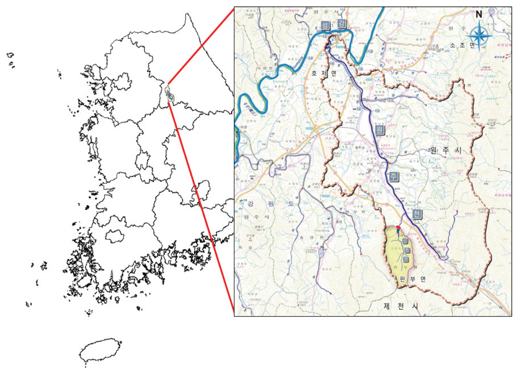
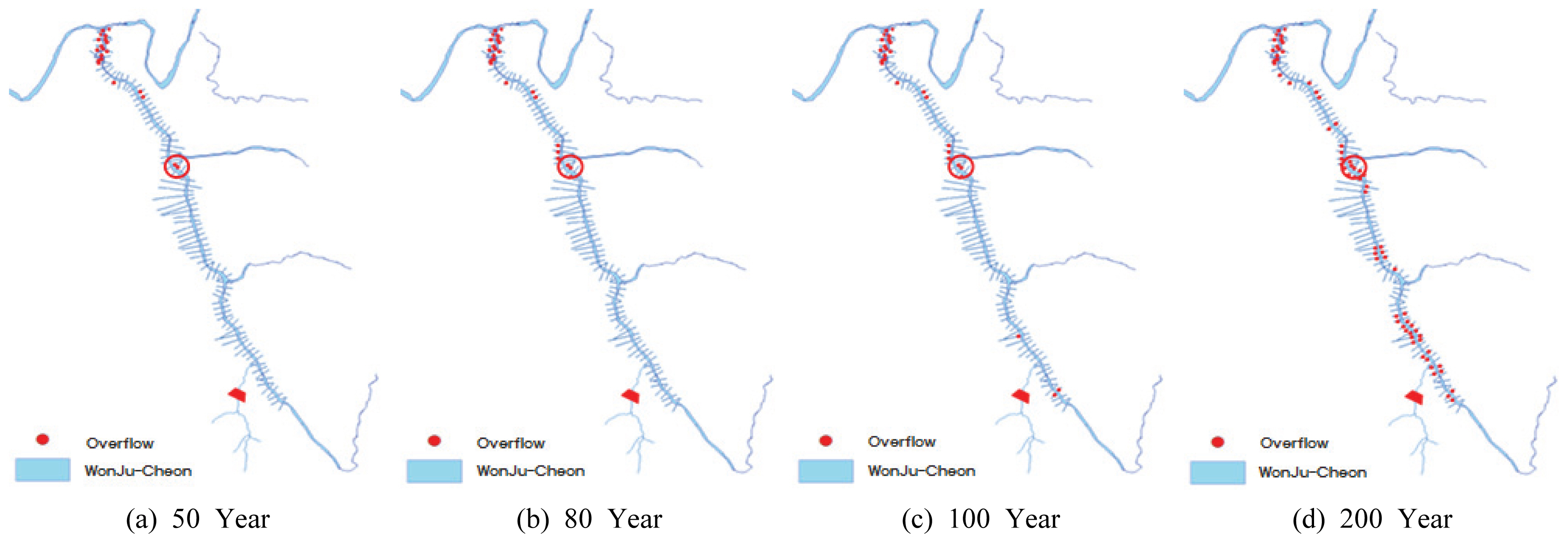
Ž≥ł žóįÍĶ¨žóźžĄú ŽŹĄžč¨žĚĄ ŪĚźŽ•īŽäĒ ŽŹĄžčúŪēėž≤úžĚł žõźž£ľž≤ú žú†žó≠žĚĄ ŽĆÄžÉĀžú†žó≠žúľŽ°ú žĄ†ž†ēŪēėžėÄŽč§(Fig. 4). žõźž£ľž≤úžĚÄ žĄ¨ÍįēžĚė ž†ú1žßÄŽ•ėŽ°úžĄú žú†žó≠Ž©īž†Ā 152.93 km2, žú†Ž°úžóįžě• 29.08 kmŽ°ú žĄ¨Íįē žú†žó≠Ž©īž†ĀžĚė žēĹ 10.26%Ž•ľ ž†źŪēėÍ≥† žěąžúľŽ©į, ÍįēžõźŽŹĄ Ūö°žĄĪÍĶį ŽĎĒŽāīŽ©īÍ≥ľ ŪŹČžįĹÍĶį ŽīČŪŹČŽ©īžĚė Í≤ĹÍ≥ĄžĚī žěąŽäĒ žį®žēÖžāį Žā®ŪÉúŽīȞ󟞥ú ŽįúžõźŪēėžó¨ žõźž£ľžčúŽ•ľ žßÄŽāė žĄ¨Íįē žĘĆžēąžł°žúľŽ°ú žú†žěÖŽźėŽäĒ ÍįēžĚīŽč§. žõźž£ľž≤ú žú†žó≠žĚÄ žõźž£ľžčúŽ•ľ ÍīÄŪÜĶŪēėžó¨ ŽŹĄžč¨žßÄ žú†žó≠Í≥ľ žāįžßÄŽ∂Ä žú†žó≠žúľŽ°ú ÍĶ¨Ž∂ĄŽźėŽ©į, žú†Ž°úžĚė ŪėēžĄĪžĚī žú†žó≠žĚė ž§Ďžč¨Ž∂ÄŽ•ľ ÍīÄŽ•ėŪēėÍ≥† žěąžĖī Ūēėž≤ú žĘĆ‚čÖžöįžēą žł°žĚė žú†žó≠Ž©īž†ĀžĚī ŽĻĄžä∑Ūēú ŪéłžĚīŽč§. 1999ŽÖĄ Ūēėž≤úž†ēŽĻĄÍłįŽ≥łÍ≥ĄŪöćžóź žĚėÍĪįŪēėžó¨ ŪēėŽ•ėÍĶ¨ÍįĄ 80ŽÖĄ ŽĻąŽŹĄ, žÉĀŽ•ėÍĶ¨ÍįĄ 50ŽÖĄ ŽĻąŽŹĄžĚė ŪôćžąėžúĄŽ°ú Í≥ĄŪöćžóź ŽįėžėĀŽźėžóąŽč§. žĚīžóź ŽĒįŽĚľ Ž≥ł žóįÍĶ¨žóźžĄú ŽĻąŽŹĄŽ≥Ą žú†ž∂úŽüȞ̥ žāįž†ēŪēėŽäĒŽćį žěąžĖī 50ŽÖĄ, 80ŽÖĄ, 100ŽÖĄ, 200ŽÖĄ 4Íįú ŽĻąŽŹĄžóź ŽĆÄŪēú žú†ž∂úŽüȞ̥ žāįž†ēŪēėžó¨ Ž∂ĄžĄĚžĚĄ žč§žčúŪēėžėÄŽč§.
3.2 žěÖŽ†•žěźŽ£Ć ÍĶ¨ž∂ē
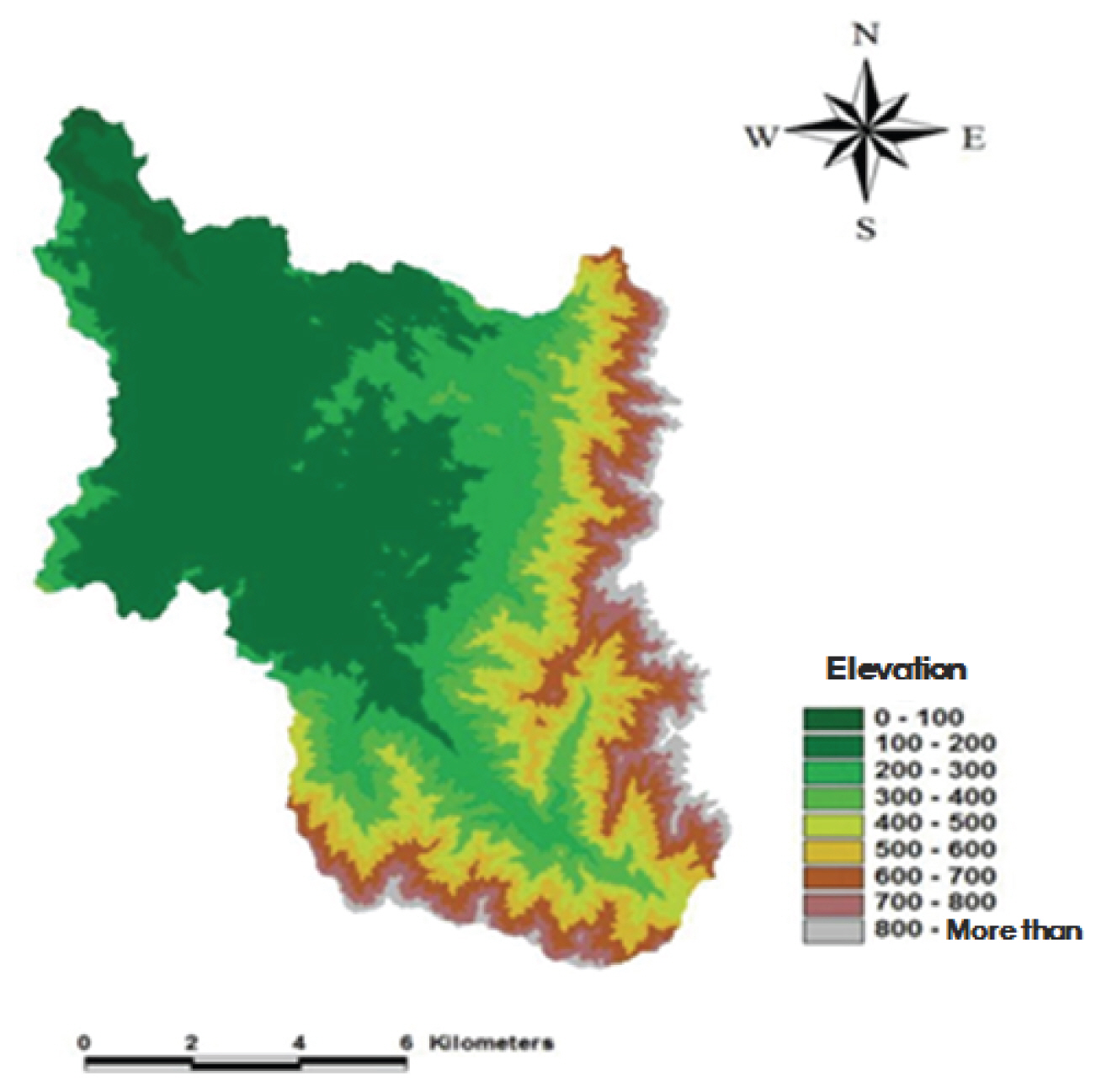
ŪôćžąėŽ≤ĒŽěĆŽ™®ŪėēžĚł Flo-2DŽ™®ŪėēžĚė žěÖŽ†•žěźŽ£ĆŽ°úŽäĒ žąėžĻėŪĎúÍ≥†Ž™®Žćł(DEM)Í≥ľ žú†ž∂úŽüČ žěźŽ£ĆÍįÄ ŪēĄžöĒŪēėŽ©į, žąėžĻėŪĎúÍ≥†Ž™®Žćł(DEM)žĚė Í≤Ĺžöį 1:5,000 žąėžĻėžßÄŽŹĄŽ•ľ žĚīžö©ŪēėžėÄŽč§(Fig. 5).
žú†ž∂úŽüČ žāįž†ēžĚė Í≤Ĺžöį Francis ž†ĄŪŹ≠žõ®žĖī Í≥Ķžč̞̥ žĚīžö©Ūēėžó¨ žāįž†ēŪēėžėÄŽč§. Ž≥ł žóįÍĶ¨žóźžĄúŽäĒ ž†úŽį©žĚė ŪĆĆž†úŽ°ú žĚłŪēú ŪôćžąėÍįÄ žēĄŽčĆ ž†úŽį© žõĒŽ•ėŽ°ú žĚłŪēú Ūôćžąėžóź ŽĆÄŪēėžó¨ Ž™®žĚėŪēėÍ≥†žěź ŪēėžėÄžúľŽ©į žõźž£ľž≤úŽĆź ŪÉÄŽčĻžĄĪž°įžā¨(K-Water, 2015)žĚė ž†úŽį©Í≥†, ŽĻąŽŹĄŽ≥Ą(50ŽÖĄ, 80ŽÖĄ, 100ŽÖĄ, 200ŽÖĄ) ŪôćžąėžúĄ žěźŽ£ĆŽ•ľ žĚīžö©Ūēėžó¨(Table 3) Fig. 6Í≥ľ ÍįôžĚī ŽĆÄžÉĀžßÄž†źžĚĄ žĄ†ž†ēŪēėžėÄŽč§. ŽĆÄžÉĀžßÄž†źžĚė Í≤Ĺžöį Ž™®Žď† ŽĻąŽŹĄžóźžĄú Ž≤ĒŽěĆžĚī ŽįúžÉĚŪēėŽäĒ Í≥≥žúľŽ°ú žĄ†ž†ēŪēėžėÄŽč§.
žó¨ÍłįžĄú LžĚÄ Í≥ĶžĻ≠žõ®žĖī ŪŹ≠, HŽäĒ žõ®žĖīžúĄžóźžĄúžĚė žąėžč¨žĚīŽč§.
3.3 Flo-2D Ž™®ŪėēžĚĄ žĚīžö©Ūēú ŪôćžąėŽ™®žĚė
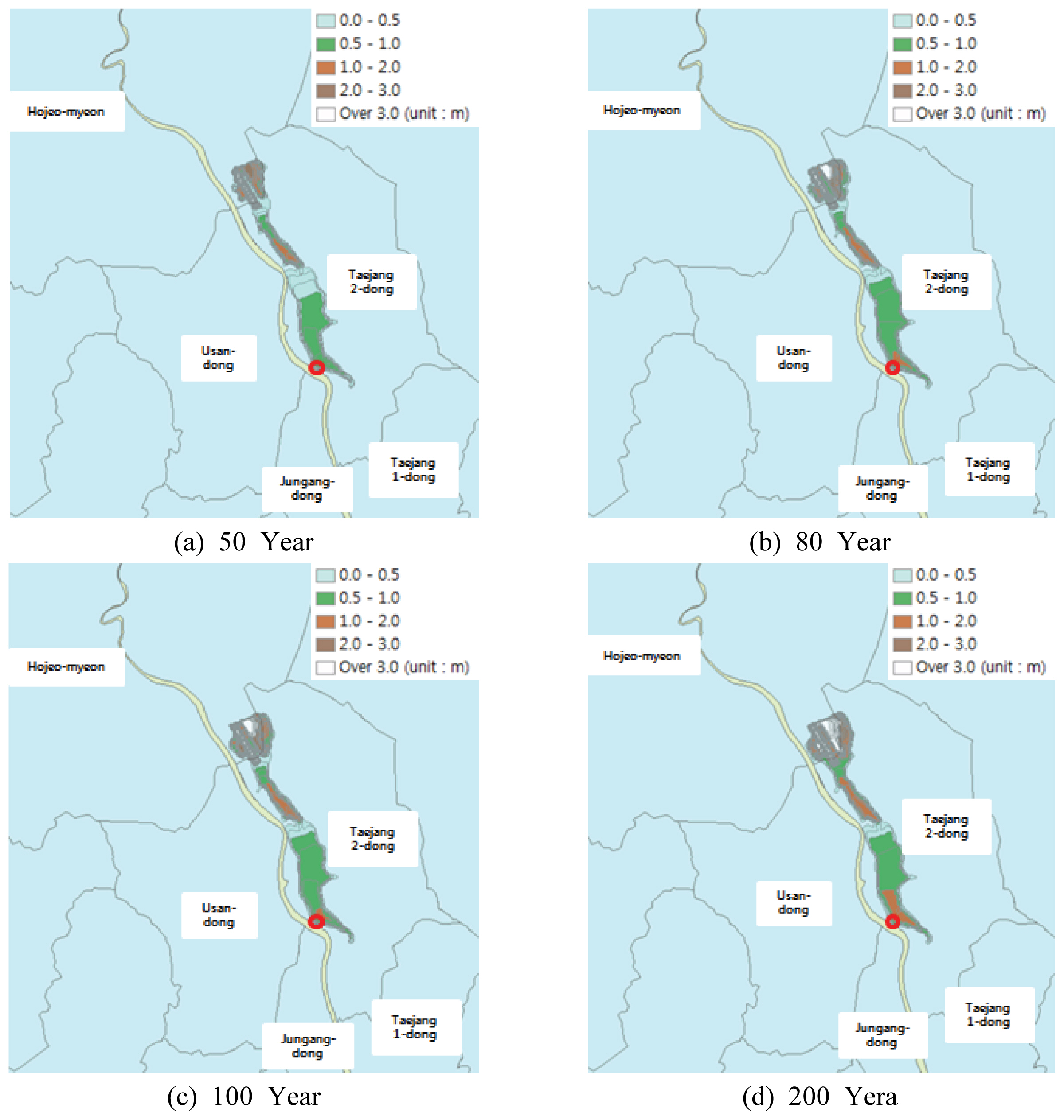
žĄ†ž†ēŽźú ŽĆÄžÉĀžßÄž†źžóź ŽĆÄŪēėžó¨ ŽĻąŽŹĄŽ≥Ą(50ŽÖĄ, 80ŽÖĄ, 100ŽÖĄ, 200ŽÖĄ) ŪôćžąėžúĄŽ•ľ žāįž†ēŪēú ŪõĄ 4žčúÍįĄ ŽŹôžēą ŪôćžąėŪĒľŪēīÍįÄ žĚľžĖīŽā¨Žč§ŽäĒ ÍįÄž†ēŪēėžóź ŪĒľŪēīŽ©īž†Ā, ŪĒľŪēīžē°žĚĄ žāįž†ēŪēėžėÄŽč§. Fig. 7žóźžĄú žĄ†ž†ēŽźú ŽĆÄžÉĀžßÄž†źžóźžĄú ŪôćžąėŽ≤ĒŽěĆ Ž™®žĚėŽ•ľ žč§žčúŪēėžėÄžúľŽ©į ŪĒľŪēīŽ©īž†ĀžĚė Í≤Ĺžöį Table 4žôÄ ÍįôŽč§.
3.4 žĻ®žąėŪéłžěÖŽ•† žāįž†ē
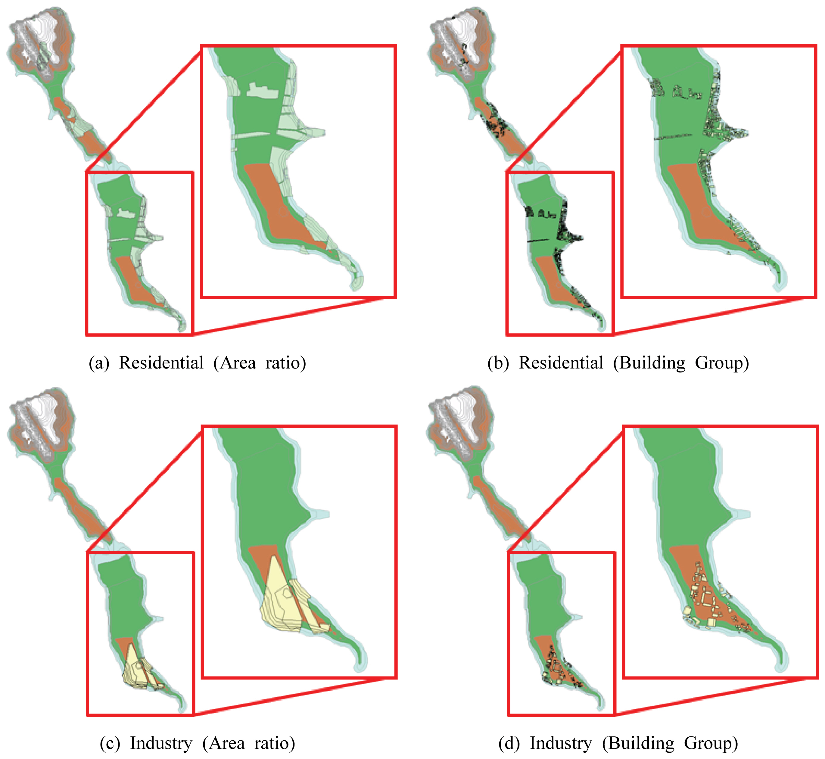
Žč§žį®žõźŪôćžąėŪĒľŪēīžāįž†ēŽ≤ēžóźžĄú ž†úžčúŪēėÍ≥† žěąŽäĒ ŪéłžěÖŽ•† žāįž†ē Žį©Ž≤ēžúľŽ°ú ŽÜćžóÖžßÄžó≠žĚÄ Ž©īž†ĀŽĻĄŽ•ľ žĚīžö©Ūēėžó¨ ŪéłžěÖŽ•†žĚĄ žāįž†ēŪēėŽ©į ž£ľÍĪįžßÄžó≠, žāįžóÖžßÄžó≠žĚė Í≤Ĺžöį Í≥ĶÍįĄÍįĚž≤ī(ÍĪīŽ¨ľÍĶį)Žď§žĚė žúĄžĻėž†ēŽ≥īŽ•ľ žĚīžö©Ūēėžó¨ žāįž†ēŪēúŽč§. ŪēėžßÄŽßĆ žč§ž†ú Ž∂ĄžĄĚžčú Í≥ĶÍįĄÍįĚž≤īžóź ŽĆÄŪēú žěźŽ£Ć žąėžßĎžĚī žö©žĚī ŪēėžßÄ žēäžēĄ Ž©īž†ĀŽĻĄŽ°ú žāįž†ēŪēėŽäĒ Žį©Ž≤ēžĚī ŽßéžĚī žā¨žö©ŽźėÍ≥† žěąŽč§. Ž≥ł žóįÍĶ¨žóźžĄúŽäĒ Ž©īž†ĀŽĻĄŽ•ľ žĚīžö©Ūēú žĻ®žąėŪéłžěÖŽ•† žāįž†ēŽį©Ž≤ēÍ≥ľ Í≥ĶÍįĄÍįĚž≤īžĚė žúĄžĻėž†ēŽ≥īŽ•ľ žĚīžö©Ūēú žāįž†ēŽį©Ž≤ēžĚė ŽĻĄÍĶźŽ•ľ ŪÜĶŪēėžó¨ ŪĒľŪēīžē°žĚė žį®žĚīŽ•ľ Ž∂ĄžĄĚŪēėÍ≥†žěź ŪēėžėÄŽč§. Ž∂ĄžĄĚžóźžĄú žā¨žö©ŽźėŽäĒ Ū܆žßÄžĚīžö©ŽŹĄŽäĒ ÍĶ≠ÍįÄÍ≥ĶÍįĄž†ēŽ≥īŪŹ¨ŪĄłžóźžĄú ž†úÍ≥ĶŪēėŽäĒ 2008ŽÖĄ Ū܆žßÄžĚīžö©ŽŹĄ žěźŽ£ĆŽ•ľ žā¨žö©ŪēėžėÄŽč§.
Fig. 8Í≥ľ ÍįôžĚī ÍĪīŽ¨ľÍĶį žĚłŽ≤§Ū܆Ž¶¨Ž•ľ Í≥†Ž†§Ūēú Í≤Ĺžöį GISžÉĀžóź ŽŹĄžčúŪôĒŽźėŽäĒ ž†ēŪēīžßĄ ÍĪīŽ¨ľ žąė ŽĆÄŽĻĄ ŪĒľŪēīŽįõžĚÄ ÍĪīŽ¨ľžąėŽ°ú ŪéłžěÖŽ•†žĚī žāįž†ēŽźėŽäĒŽćį Ū܆žßÄžĚīžö©ŽŹĄŽ•ľ žĚīžö©Ūēú Ž©īž†ĀŽĻĄ ŪéłžěÖŽ•†žĚė Í≤Ĺžöį žč§ž†ú ÍĪīŽ¨ľŽ≥īŽč§ ŽĄďÍ≤Ć Ū܆žßÄžĚīžö©ŽŹĄ žÉĀžóź ž£ľÍĪįžßÄžó≠, žāįžóÖžßÄžó≠žúľŽ°ú ŪĎúŪėĄžĚī ŽźėžĖī Ž≥īŽč§ ŽāģžĚÄ ŪéłžěÖŽ•†žĚī žāįž†ēŽźėŽäĒ Í≤ÉžúľŽ°ú ŪĆźŽč®ŽźėžóąŽč§.
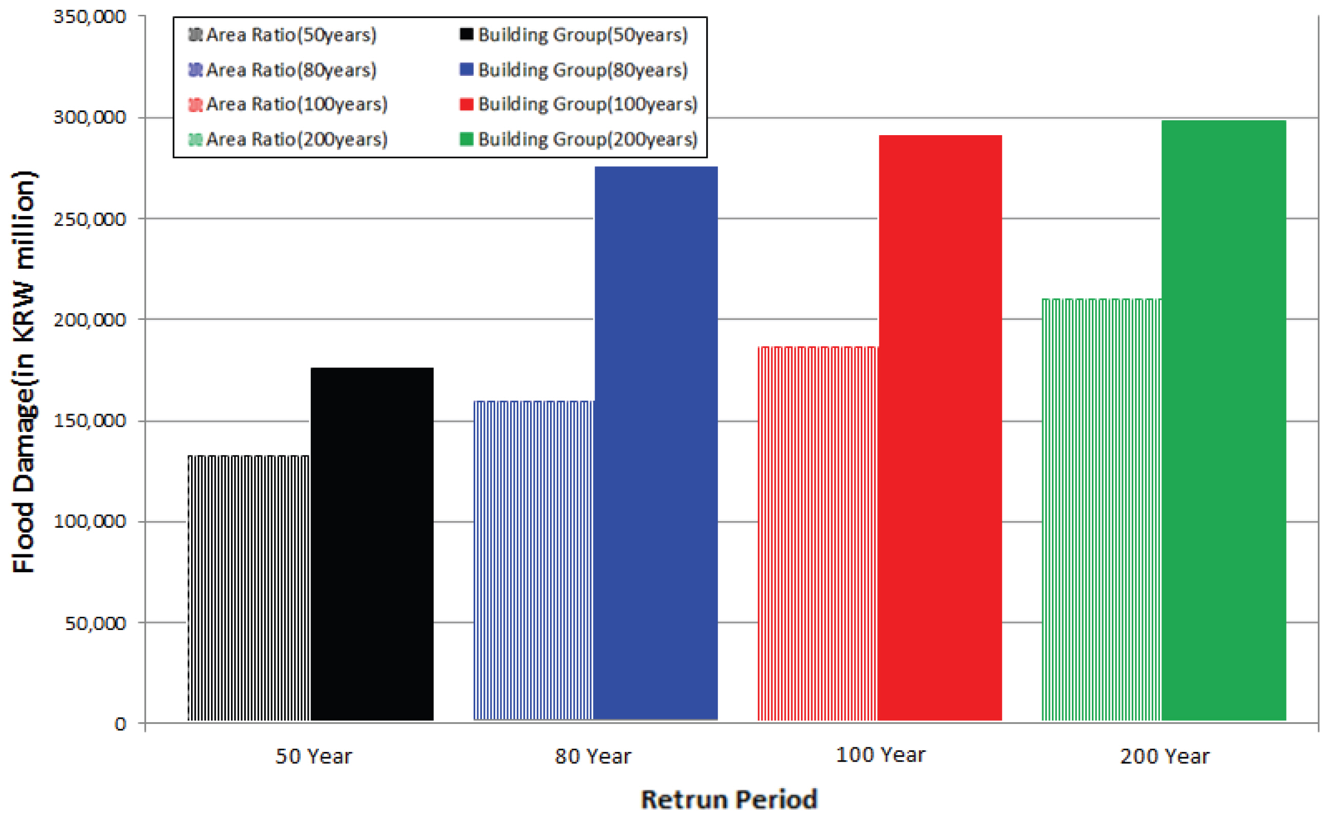
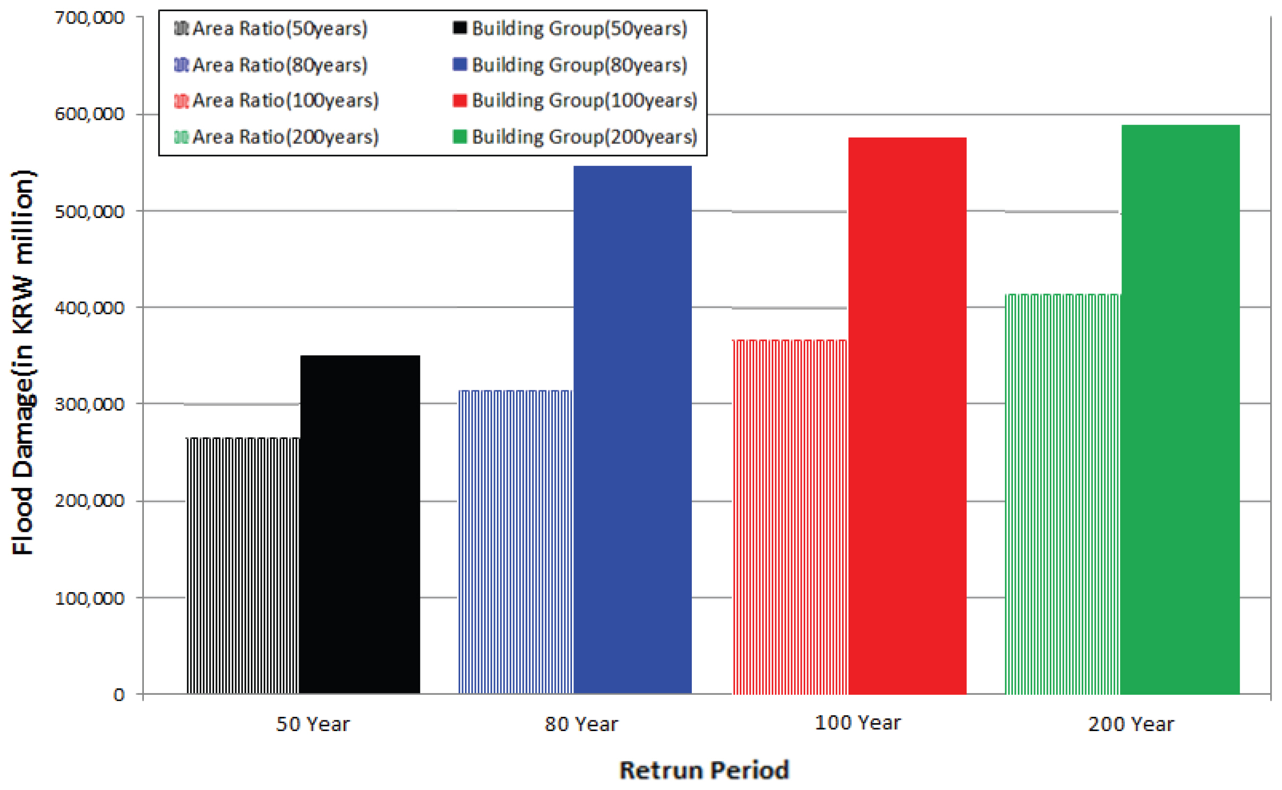
Table 5ŽäĒ Ž©īž†ĀŽĻĄžôÄ ÍĪīŽ¨ľÍĶįžĚĄ žĚīžö©ŪēėžėĞ̥ ŽēĆžĚė žßĀž†ĎŪĒľŪēīžē° ŽĻĄÍĶź Í≤įÍ≥ľŪĎúžĚīŽč§. Fig. 9žôÄ ÍįôžĚī Ž©īž†ĀŽĻĄ žāįž†ēŽį©Ž≤ēžóź ŽĒįŽ•ł žßĀž†ĎŪĒľŪēīžē° ŽĻĄÍĶź Í≤įÍ≥ľ 50ŽÖĄ ŽĻąŽŹĄ ÍĪīŽ¨ľÍĶį ŪéłžěÖŽ•†žĚĄ žĚīžö©Ūēú ŪôćžąėŪĒľŪēīžē°žĚī 100ŽÖĄ ŽĻąŽŹĄ Ž©īž†ĀŽĻĄŽ•ľ žĚīžö©Ūēú ŪéłžěÖŽ•†žĚĄ žĚīžö©ŪēėžėĞ̥ ŽēĆžĚė ŪĒľŪēīžē°Í≥ľ ŽĻĄžä∑ŪēėÍ≤Ć ŽāėŪÉÄŽā¨žúľŽ©į 80ŽÖĄ ŽĻąŽŹĄ ÍĪīŽ¨ľÍĶį ŪéłžěÖŽ•†žĚĄ žĚīžö©ŪēėžėĞ̥ ŽēĆ 100ŽÖĄ, 200ŽÖĄ Ž©īž†ĀŽĻĄŽ•ľ žĚī žö©ŪēėžėĞ̥ ŽēĆžĚė ŪĒľŪēīžē°Ž≥īŽč§ ŽÜížĚÄ ŪĒľŪēīžē°žĚī ŽāėŪÉÄŽāėŽäĒ Í≤ɞ̥ ŪôēžĚł Ūē† žąė žěąžóąŽč§.
3.5 Í≥ĶÍ≥ĶžčúžĄ§Ž¨ľ ŪĒľŪēīžē° žāįž†ē
Í≥ĶÍ≥ĶžčúžĄ§Ž¨ľ ŪĒľŪēīžē° žāįž†ēžĚĄ žúĄŪēėžó¨ Table 2žĚė KDI (2008)žóźžĄú ž†úžčúŪēėÍ≥† žěąŽäĒ žĚľŽ≥ł ÍĶ≠Ū܆ÍĪīžĄ§žĄĪ Í≥ĶÍ≥ĶžčúžĄ§Ž¨ľ ŪĒľŪēīžē°ŽĻĄžú®žĚĄ ž†Āžö©Ūēėžó¨ Ū܆žßÄžĚīžö©ŽŹĄžÉĀžóź žĻ®žąėÍįÄ ŽįúžÉĚŪēú žĚ掩īŽŹô Žāī žĻ®žąėŽ©īž†Āžóź ŪŹ¨Ūē®ŽźėŽäĒ Ūē≠Ž™©žóź ŽĆÄŪēīžĄú ž†Āžö©Ūēėžó¨ žßĀž†ĎŪĒľŪēīžē°žóź Í≥ĶÍ≥ĶžčúžĄ§Ž¨ľ ŪĒľŪēīŽĻĄžú®žĚĄ ž†Āžö©Ūēėžó¨ žāįž†ēŪēėžėÄŽč§. žē장ú žĖłÍłČŪēėžėÄŽďĮžĚī ÍĪīŽ¨ľÍĶį žĚłŽ≤§Ū܆Ž¶¨žĚė Í≤Ĺžöį Í≥ĶÍ≥ĶžčúžĄ§žóź ŽĆÄŪēú ÍĪīŽ¨ľžö©ŽŹĄ žěźŽ£ĆÍįÄ Ž∂Äž°ĪŪēėžó¨ Ū܆žßÄžĚīžö©ŽŹĄ žěźŽ£ĆžôÄ ž§Ďž≤©Ūēėžó¨ ž§Ďž≤©ŽźėŽäĒ Ž∂ÄŽ∂Ąžóź ŽĆÄŪēėžó¨ Í≥ĶÍ≥ĶžčúžĄ§Ž¨ľŽ°ú žĄ†ž†ēŪēėžó¨ Ž∂ĄžĄĚŪēėžėÄŽč§. žĻ®žąėŪĒľŪēīÍįÄ ŽįúžÉĚŪĖąŽćė Ūėłž†ÄŽ©ī, ŪÉúžě•2ŽŹôžóź ŽĆÄŪēú Í≥ĶÍ≥ĶžčúžĄ§Ž¨ľ ŪĒľŪēīžē°žāįž†ēÍ≤įÍ≥ľŽäĒ Table 6Í≥ľ ÍįôŽč§. ŽĻąŽŹĄŽ≥Ą ŽĎź žßÄžó≠žĚė Í≥ĶÍ≥ĶžčúžĄ§Ž¨ľ ŪĒľŪēīžē° Ūē©žāįŪēėžó¨ žīĚ ŪĒľŪēīžē°žóź žĚīžö©ŪēėžėÄžúľŽ©į Í≥ĶÍ≥ĶžčúžĄ§Ž¨ľ ŪĒľŪēīžē° ŽĻĄÍĶźÍ≤įÍ≥ľ Ž©īž†ĀŽĻĄŽ•ľ žĚīžö©ŪēėžėĞ̥ ŽēĆ ŪŹČÍ∑† 67% ž†ĀÍ≤Ć žāįž†ēŽźėžóąŽč§.
3.6 žīĚ ŪĒľŪēīžē° žāįž†ē
žīĚ ŪĒľŪēīžē° žāįž†ēžĚĄ žúĄŪēėžó¨ Ž≥ł žóįÍĶ¨žóźžĄúŽäĒ žĚłŽ™ÖŪĒľŪēīžē°žĚĄ ž†úžôłŪēú žßĀž†ĎŪĒľŪēīžē°, Í≥ĶÍ≥ĶžčúžĄ§Ž¨ľ ŪĒľŪēīžē° žāįž†ēŪõĄ ŪéłžěÖŽ•†žóź ŽĒįŽ•ł žīĚ ŪĒľŪēīžē°žĚĄ žāįž†ēŪēėžėÄŽč§. Fig. 8žĚÄ Ž©īž†ĀŽĻĄŪéłžěÖŽ•†žĚĄ žĚīžö©Ūēú ŪĒľŪēīžē° žāįž†ēŽį©Ž≤ēžĚĄ ŪÜĶŪēėžó¨ Žāėžė® žīĚ ŪĒľŪēīžē°Í≥ľ Ž≥ł žóįÍĶ¨žóźžĄú žāįž†ēŪēú ÍĪīŽ¨ľÍĶįŪéłžěÖŽ•†žĚĄ žĚīžö©Ūēú žīĚ ŪĒľŪēīžē°žĚĄ ŽĻĄÍĶźŪēú Í∑łŽ¶ľžĚīŽč§. žßĀž†ĎŪĒľŪēīžē° žāįž†ēÍ≤įÍ≥ľžôÄ žú†žā¨Ūēú Í≤įÍ≥ľÍįÄ žīĚ ŪĒľŪēīžē°žĚī žāįž†ēŽźėžóąžúľŽ©į ÍĪīŽ¨ľÍĶįžĚĄ žĚīžö©Ūēú žīĚ ŪĒľŪēīžē°žĚī Ž©īž†ĀŽĻĄŽ•ľ žĚīžö©ŪēėžėĞ̥ ŽēĆžĚė žīĚ ŪĒľŪēīžē°Ž≥īŽč§ žēĹ 65% ž†ĀÍ≤Ć žāįž†ēŽźėžóąŽč§(Fig. 10).
4. Í≤į Ž°†
Ž≥ł žóįÍĶ¨žĚė Ž™©ž†ĀžĚÄ Žč§žį®žõźŽ≤ēžĚĄ žĚīžö©Ūēėžó¨ žĻ®žąėŪéłžěÖŽ•† žāįž†ēŽį©Ž≤ē(Ž©īž†ĀŽĻĄ, ÍĪīŽ¨ľÍĶį žĚłŽ≤§Ū܆Ž¶¨)žóź ŽĒįŽ•ł žßĀž†ĎŪĒľŪēīžē°Í≥ľ Í≥ĶÍ≥ĶžčúžĄ§Ž¨ľŪĒľŪēīŽĻĄžú®(žĚľŽ≥ł ÍĶ≠Ū܆ÍĶźŪÜĶžĄĪ)ž†Āžö©žóź ŽĒįŽ•ł žīĚ ŪĒľŪēīžē°žóź ŽĮłžĻėŽäĒ žėĀŪĖ•žóź ŽĆÄŪēėžó¨ ŪŹČÍįÄŪēėžėÄŽč§. ŽĆÄžÉĀžú†žó≠žúľŽ°ú ŽŹĄžčúŪēėž≤úžĚł žõźž£ľž≤úžú†žó≠žúľŽ°ú žĄ†ž†ēŪēėžėÄžúľŽ©į ŪôćžąėŽ≤ĒŽěĆŽ™®ŪėēžĚł Flo-2D Ž™®ŪėēžĚĄ žĚīžö©Ūēėžó¨ ŽĻąŽŹĄŽ≥Ą(50ŽÖĄ, 80ŽÖĄ, 100ŽÖĄ, 200ŽÖĄ) ŪôćžąėŽ≤ĒŽěĆŽ™®žĚėŽ•ľ žč§žčúŪēėžėÄŽč§. žĻ®žąėŪéłžěÖŽ•† žāįž†ēžčú žĚľŽįėž†ĀžúľŽ°ú žā¨žö©ŽźėŽäĒ Ž©īž†ĀŽĻĄŽ•ľ žĚīžö©Ūēú Žį©Ž≤ēÍ≥ľ žč§ž†ú ÍĪīŽ¨ľÍĶį žĚłŽ≤§Ū܆Ž¶¨Ž•ľ žĚīžö©Ūēú Žį©Ž≤ēžĚĄ žĚīžö©ŪēėžėÄžúľŽ©į žĚľŽįėžěźžāį ŪĒľŪēīžē°žĚĄ žāįž†ēŪēėžó¨ ŽĻĄÍĶźŪēėžėÄŽč§. žīĚ ŪĒľŪēīžē° žāįž†ēžóźžĄúŽäĒ KDI (2008)žóźžĄú ž†úžčúŪēėÍ≥† žěąŽäĒ žĚľŽ≥ł ÍĶ≠Ū܆ÍĪīžĄ§žĄĪ Í≥ĶÍ≥ĶžčúžĄ§Ž¨ľ ŪĒľŪēīŽĻĄžú®žĚĄ ž†Āžö©Ūēėžó¨ Ž∂ĄžĄĚŪēėžėÄŽč§.
(1) žĻ®žąėŪéłžěÖŽ•† žāįž†ēŽį©Ž≤ēžóź ŽĒįŽ•ł ŪĒľŪēīžē°Ž∂ĄžĄĚžóźžĄúŽäĒ žĻ®žąėŪéłžěÖŽ•† žāįž†ēŽį©Ž≤ēžóź ŽĒįŽ•ł ŪôćžąėŪĒľŪēīžē°žĚĄ Ž∂ĄžĄĚŪēėÍ≥†žěź ŪēėžėÄŽč§. žĻ®žąėŽ©īž†ĀÍ≥ľ Ū܆žßÄžĚīžö©žóź ŽĒįŽ•ł Ž©īž†ĀŽĻĄŽ•ľ žĚīžö©Ūēú ŪéłžěÖŽ•† žāįž†ēŽį©Ž≤ēÍ≥ľ žĻ®žąėŽ©īž†ĀÍ≥ľ ÍĪīŽ¨ľÍĶįžĚĄ žĚīžö©Ūēú ŪéłžěÖŽ•† žāįž†ēŽį©Ž≤ēžĚĄ ŽĻĄÍĶźŪēėžėÄŽč§. ŽĻĄÍĶź Í≤įÍ≥ľ ÍĪīŽ¨ľÍĶįžĚĄ žĚīžö©Ūēú ŪéłžěÖŽ•†žĚī Ž©īž†ĀŽĻĄŽ•ľ žĚīžö©Ūēú ŪéłžěÖŽ•†Ž≥īŽč§ ŽÜížĚÄ ŪéłžěÖŽ•†žĚĄ Ž≥īžėÄŽč§. žāįž†ēŽźú ŪéłžěÖŽ•†žĚĄ žĚīžö©Ūēėžó¨ žßĀž†ĎŪĒľŪēīžē°žĚĄ žāįž†ēŪēú Í≤įÍ≥ľ Ž©īž†ĀŽĻĄ ŪéłžěÖŽ•†žĚĄ žĚīžö©Ūēú ŪĒľŪēīžē°žĚī ÍĪīŽ¨ľÍĶį ŪéłžěÖŽ•†žĚĄ žĚīžö©Ūēú ŪĒľŪēīžē°Ž≥īŽč§ žĶúžÜĆ 51%, žĶúŽĆÄ 75% ŽāģžĚÄ ŪĒľŪēīžē°žĚī žāįž†ēŽźėžóąŽč§.
(2) Í≥ĶÍ≥ĶžčúžĄ§Ž¨ľ žāįž†ēŽį©Ž≤ēžóź ŽĒįŽ•ł ŪĒľŪēīžē°žóźžĄúŽäĒ žĚľŽ≥ł ÍĪīžĄ§žĄĪžóźžĄú ž†úžčúŪēú Í≥ĶÍ≥ĶžčúžĄ§Ž¨ľŪĒľŪēīŽĻĄžú®žĚĄ ž†Āžö©ŪēėžėĞ̥ ŽēĆ ŪĒľŪēīžē°žĚė žį®žĚīŽ•ľ ŽĻĄÍĶźŪēėžėÄŽč§. ŽĎź ÍįÄžßÄ ŪéłžěÖŽ•† žāįž†ēŽį©Ž≤ēžóź ŽĒįŽ•ł Í≥ĶÍ≥ĶžčúžĄ§Ž¨ľ ŪĒľŪēīŽĻĄžú®žĚĄ ž†Āžö©Ūēėžó¨ Í≥ĶÍ≥ĶžčúžĄ§Ž¨ľ ŪĒľŪēīžē°žĚĄ žāįž†ēŪēėžėĞ̥ ŽēĆ Ž©īž†ĀŽĻĄ ŪéłžěÖŽ•†žĚĄ žĚīžö©Ūēú ŪĒľŪēīžē°žĚī ŪŹČÍ∑† 67% ŽāģÍ≤Ć žāįž†ēŽźėžóąŽč§.
Íłįž°ī žóįÍĶ¨žóźžĄúŽäĒ žě†žě¨žĻ®žąėÍĶ¨žó≠žĚĄ žĚīžö©Ūēėžó¨ žĶúžĘÖŪôćžąėŪĒľŪēīŽ©īž†Āžóź ŽĆÄŪēú Ž∂ĄžĄĚžĚī žč§žčúŽźėÍ≥†žěąžßÄŽßĆ Ž≥ł žóįÍĶ¨žóźžĄúŽäĒ ŪôćžąėŽ≤ĒŽěĆŽ™®ŪėēžĚĄ žĚīžö©Ūēėžó¨ žčúÍįĄžóź ŽĒįŽ•ł ŪôćžąėŪĒľŪēīŽ©īž†Āžóź ŽĆÄŪēú Ž∂ĄžĄĚžĚĄ žč§žčúŪēėžó¨ ŪôćžąėŪĒľŪēī ŽĆÄŽĻĄ‚čÖŽĆÄžĚĎžóź ž†Āžö©Ūē† žąė žěąžĚĄ Í≤ÉžúľŽ°ú ŪĆźŽč®ŽźėŽ©į, ŪôćžąėŪĒľŪēī ŽĆÄŽĻĄ‚čÖŽĆÄžĚĎžóź ŽĒįŽ•ł ŪôćžąėŪĒľŪēīžē° ž†ÄÍįźžóźŽŹĄ ŽŹĄžõÄžóź Žź† Í≤ÉžúľŽ°ú ŪĆźŽč®ŽźúŽč§.
žĻ®žąėŪéłžěÖŽ•†Í≥ľ ÍīÄŽ†®Ūēėžó¨ ÍĪīŽ¨ľÍĶįžĚĄ žĚīžö©Ūēú ŪéłžěÖŽ•†žĚė Í≤Ĺžöį ŪĒľŪēīŽ©īž†Āžóź ŪŹ¨Ūē®ŽźėŽäĒ ÍĪīŽ¨ľ žąėŽ•ľ Í≥ĄžāįŪēėžó¨ ŪéłžěÖŽ•†žĚĄ žāįž†ēŪēėžßÄŽßĆ Ū܆žßÄžĚīžö©ŽŹĄŽ•ľ žĚīžö©Ūēú Ž©īž†ĀŽĻĄ ŪéłžěÖŽ•†žĚė Í≤Ĺžöį žč§ž†ú ÍĪīŽ¨ľŽ≥īŽč§ ŽĄďÍ≤Ć Ū܆žßÄžĚīžö©ŽŹĄ žÉĀžóź ž£ľÍĪįžßÄžó≠, žāįžóÖžßÄžó≠žúľŽ°ú ŪĎúŪėĄžĚī ŽźėžĖī Ž≥īŽč§ ŽāģžĚÄ ŪéłžěÖŽ•†žĚī žāįž†ēŽźėžóąŽč§. žāįž†ēŽźú Ž©īž†ĀŽĻĄ ŪéłžěÖŽ•†Í≥ľ ÍĪīŽ¨ľÍĶį žĚłŽ≤§Ū܆Ž¶¨ ŪéłžěÖŽ•†žĚĄ žĚīžö©Ūēėžó¨ žĚľŽįėžěźžāįŪĒľŪēīžē°Í≥ľ Í≥ĶÍ≥ĶžčúžĄ§Ž¨ľŪĒľŪēīžē°žĚĄ žāįž†ēŪēėžėÄŽēĆ ŽāģÍ≤Ć žāįž†ēŽźú Ž©īž†ĀŽĻĄ ŪéłžěÖŽ•†žĚĄ žĚīžö©Ūēú žīĚ ŪĒľŪēīžē°žĚī ž†ĀÍ≤Ć ŽāėžėīžĚĄ ŪôēžĚł Ūē† žąė žěąžóąŽč§. žĶúÍ∑ľ ž†ĄÍĶ≠ž†ĀžúľŽ°ú ÍĪīŽ¨ľÍĶį žĚłŽ≤§Ū܆Ž¶¨ÍįÄ ÍĶ¨ž∂ēŽźėÍ≥† žěąŽäĒ ž∂ĒžĄłžĚīŽ©į Žč§žį®žõźŽ≤ēžóźžĄúŽŹĄ ž£ľÍĪįžßÄžó≠Í≥ľ žāįžóÖžßÄžó≠žĚė Í≤ĹžöįžóźŽäĒ ÍĪīŽ¨ľÍĶįžĚĄ žĚīžö©Ūēėžó¨ Ž∂ĄžĄĚŪēėŽŹĄŽ°Ě ž†ēžĚėŽźėžĖī žěąÍłį ŽēĆŽ¨łžóź Žč§žį®žõźŽ≤ēžĚĄ žĚīžö©Ūēėžó¨ ŪôćžąėŪĒľŪēīžē°žĚĄ žāįž†ēŪēėÍłį žúĄŪēīžĄúŽäĒ Ž©īž†ĀŽĻĄŽ•ľ Ūôúžö©ŪēėŽäĒ Í≤ÉŽ≥īŽč§ ÍĪīŽ¨ľÍĶį žĚłŽ≤§Ū܆Ž¶¨Ž•ľ Ūôúžö©ŪēėŽäĒ Í≤ÉžĚī ŽįĒŽěĆžßĀŪēėŽč§Í≥† ŪĆźŽč®ŽźúŽč§.