


1. м„ңлЎ
мҡ°лҰ¬лӮҳлқјлҠ” м—¬лҰ„мІ м—җ к°•мҡ°к°Җ 집мӨ‘лҗҳлҠ” кё°мғҒн•ҷм Ғ м—¬кұҙкіј лҢҖмҲҳмёөмқҙ л°ңлӢ¬н•ҳм§Җ лӘ»н•ң м§Җнҳ•н•ҷм Ғ м—¬кұҙмңјлЎң к°Җлӯ„м—җ л§Өмҡ° м·Ём•Ҫн•ҳкі , нҠ№нһҲ 2015л…„м—җлҠ” л©”лҘҙмҠӨ л°”мқҙлҹ¬мҠӨм—җ мқҙм–ҙ лҢҖк°Җлӯ„мқҙлқјлҠ” лҳҗ н•ҳлӮҳмқҳ мһ¬лӮңм—җ мӢңлӢ¬л ёлӢӨ(Kim and Park, 2015). кё°мғҒмІӯм—җ л”°лҘҙл©ҙ 2015л…„ 1мӣ” 1мқјл¶Җн„° 2015л…„ 11мӣ”к№Ңм§Җ м „көӯ лҲ„м Ғ к°•мҲҳлҹүмқҖ 780.4 mmлЎң 30л…„ нҸүк· м№ҳмқё 1,241.5 mmмқҳ 62%м—җ к·ёміӨлӢӨкі н•ңлӢӨ(Kim et al., 2015). м§ҖкёҲк№Ңм§Җ лӢӨлӘ©м ҒлҢҗ к°ңл°ңкіј кҙ‘м—ӯмғҒмҲҳлҸ„л§қ нҷ•м¶© л“ұмқҳ мҲҳмһҗмӣҗ к°ңл°ңм—җ мҡ©мҲҳкіөкёүлҠҘл Ҙмқ„ н–ҘмғҒмӢңмјң к°Җлӯ„м—җ лҢҖн•ң мӢ¬к°Ғм„ұмқ„ лҠҗлҒјм§ҖлҠ” лӘ»н–Ҳм§Җл§Ң, мөңк·ј лҢҖлҸ„мӢңмқҳ нҷ•лҢҖ, мҡ©мҲҳкіөкёүмӢңм„Өмқҳ м§Җм—ӯм Ғ нҺёмӨ‘ л“ұмңјлЎң л¬ј л¶ҖмЎұ мғҒнҷ©мқҙ л°ңмғқн• мң„н—ҳмқҙ м»Өм§Җкі мһҲлӢӨ(Kim and Park, 2015). мқҙлҹ¬н•ң л¬ём ңл“ӨлЎң лӢӨм–‘н•ң лҚ°мқҙн„°лҘј нҷңмҡ©н•ң к°Җлӯ„ 분м„қ л°Ҹ лҢҖ비к°Җ н•„мҡ”н•ҳлӢӨ.
к°Җлӯ„мқҖ кҙҖмӢ¬кіј лӘ©м Ғм—җ л”°лқј кё°мғҒн•ҷм Ғ к°Җлӯ„, лҶҚм—…м Ғ к°Җлӯ„, мҲҳл¬ён•ҷм Ғ к°Җлӯ„, мӮ¬нҡҢкІҪм ңн•ҷм Ғ к°Җлӯ„мңјлЎң лӮҳлҲ 진лӢӨ(Wilhite and Glantz, 1985). мқҙлҘј 분м„қн•ҳлҠ” л°©лІ•мңјлЎң к°•мҲҳлҹү кё°л°ҳ, мҲҳмһҗмӣҗ кё°л°ҳ, к·ёлҰ¬кі мң„м„ұмҳҒмғҒ кё°л°ҳ л“ұмқҙ мһҲлӢӨ. мқҙл“Ө мӨ‘ кё°мЎҙмқҳ к°Җлӯ„ 분м„қ л°©лІ•мқҖ к°•мҲҳлҹү кё°л°ҳмқҙ мЈјлҘј мқҙлЈЁм—ҲлӢӨ. кё°мғҒн•ҷм Ғ к°Җлӯ„мқ„ лӢӨлЈЁлҠ” к°•мҲҳлҹү кё°л°ҳ 분м„қ л°©лІ•мқҖ PDSI (Palmer Drought Severity Index), SPI (Standard Precipitation Index), к·ёлҰ¬кі EDI (Effective Drought Index) л“ұмқҙ мӮ¬мҡ©лҗңлӢӨ(Lee et al., 2015a). н•ҳм§Җл§Ң к°•мҲҳлҹү кё°л°ҳмқҳ к°Җлӯ„ 분м„қ кё°лІ•л“ӨмқҖ мў…кҙҖкё°мғҒкҙҖмёЎмһҘ비(Automated Surface Observing System) нҳ№мқҖ м§Җм—ӯлі„мғҒм„ёкҙҖмёЎмһҗлЈҢ(Automatic Weather Station)лҘј мӮ¬мҡ©н•ҳмҳҖкё° л•Ңл¬ём—җ л¶Җ분м Ғмқё к°Җлӯ„мқҳ кІҪн–Ҙл§Ңмқ„ нҢҢм•…н•ҳлҠ” лӢЁм җмқҙ мһҲлӢӨ. к°•мҲҳлҹү кё°л°ҳмқҳ мҲҳл¬ён•ҷм Ғ к°Җлӯ„мқҖ мң м—ӯмқҳ к°•мҡ°, к°•м„Ө, н•ҳмІңмң м¶ң, м ҖмҲҳлҹүмқ„ мһ…л ҘмқёмһҗлЎң н•ҳлҠ” SWSI (Surface Water Supply Index)к°Җ лҢҖн‘ңм ҒмқҙлӢӨ(Kwon et al., 2007). SWSIмқҳ мһ…л ҘмқёмһҗлҠ” м„јм„ң кё°л°ҳмңјлЎң м·Ёл“қн•ҳкё° л•Ңл¬ём—җ к°•мҲҳлҹү кё°л°ҳмқҳ л°©лІ•кіј лҸҷмқјн•ң л¬ём ңм җмқ„ к°–лҠ”лӢӨ. л°ҳл©ҙ мң„м„ұмҳҒмғҒмқҖ кҙ‘лІ”мң„н•ң м§Җм—ӯмқ„ мҙ¬мҳҒн•ҳкі , л¬јкіј м§Җл©ҙмқ„ 분лҰ¬н• мҲҳ мһҲлҠ” нҢҢмһҘлҢҖ мҳҒм—ӯмқ„ м§ҖлӢҲкі мһҲлӢӨ. мқҙлҹ° нҠ№м„ұмқ„ мқҙмҡ©н•ҳм—¬ м„јм„ң мһҗлЈҢм—җл§Ң көӯн•ңлҗҳм§Җ м•Ҡкі мҲҳкі„л©ҙм Ғмқ„ 추м¶ңн•ҳм—¬ ліҙлӢӨ м •нҷ•н•ң к°Җлӯ„ мң л¬ҙлҘј нҢҢм•…н• мҲҳ мһҲм–ҙм•ј н•ңлӢӨ.
кё°мЎҙмқҳ мң„м„ұмҳҒмғҒмқ„ кё°л°ҳмңјлЎң н•ң к°Җлӯ„ 분м„қ кё°лІ•мқҖ MODIS (Moderate Resolution Imaging Spectroradiometer) мң„м„ұмҳҒмғҒм—җм„ң м •к·ңмӢқмғқм§ҖмҲҳ(Normalized Difference Vegetation Index)мҷҖ м •к·ңмҲҳ분м§ҖмҲҳ(Normalized Difference Water Index)лҘј мқҙмҡ©н•ҳм—¬ мҙҲм§Җмқҳ к°Җлӯ„ 분м„қ м—°кө¬к°Җ мһҲлӢӨ(Gu et al., 2007). Wang and Qu(2007)лҠ” нҶ м–‘кіј мӢқмғқмқҳ мҲҳ분함мң лҹүмқ„ лӘЁлӢҲн„°л§Ғн•ҳкё° мң„н•ҙ м •к·ңлӢӨмӨ‘л°ҙл“ңк°Җлӯ„м§ҖмҲҳ(Normalized Multi-band Drought Index)лҘј м ңм•Ҳн•ҳмҳҖлӢӨ. Gu et al.(2007)мқҳ кІ°кіјмҷҖ 비көҗн•ҳм—¬ л§ҢмЎұн• л§Ңн•ң м •нҷ•м„ұмқ„ лӮҳнғҖлғҲм§Җл§Ң, лӮҳм§Җ л°Ҹ мӢқмғқ м§Җм—ӯм—җм„ңлҠ” н•ңкі„лҘј лӮҳнғҖлӮҙм—ҲлӢӨ. Rhee et al.(2010)мқҖ MODISмҷҖ TRMM (Tropical Rainfall Measuring Mission) мң„м„ұмҳҒмғҒм—җм„ң м •к·ңмӢқмғқм§ҖмҲҳ, к°•мҲҳлҹү, к·ёлҰ¬кі м§Җн‘ңл©ҙ мҳЁлҸ„лҘј мқҙмҡ©н•ҙ SDCI (Scaled Drought Condition Index)лҘј мӮ°м¶ңн•ҳм—¬ к°Җлӯ„мқ„ 분м„қн•ҳмҳҖлӢӨ. лҜёкөӯ м§Җм—ӯмқ„ лҢҖмғҒмңјлЎң PDSI (Palmer Drought Severity Index), Z-index (PalmerвҖҷs Z-Index), к·ёлҰ¬кі SPI3 (Standard Precipitation Index) л“ұкіј 비көҗн•ҙліё кІ°кіј лҶ’мқҖ м •нҷ•лҸ„лҘј нҢҢм•…н• мҲҳ мһҲм—ҲлӢӨ. лҢҖл¶Җ분мқҳ к°Җлӯ„ 분м„қ м—°кө¬л“Өмқҙ мң„м„ұмҳҒмғҒмқҳ лӢӨмӨ‘л°ҙл“ңлҘј нҷңмҡ©н•ҳм—¬ к°Җлӯ„м§ҖмҲҳлҘј мӮ°м¶ңн•ҳкі , к°Җлӯ„ м§ҖлҸ„лҘј м ңмһ‘н•ҳлҠ” л°©лІ•мқ„ мқҙмҡ©н•ңлӢӨ.
ліё м—°кө¬м—җм„ңлҠ” м§Җм—ӯлі„ к°Җлӯ„ нҢҢм•…мқ„ мң„н•ҙ Landsat-8 мң„м„ұмҳҒмғҒкіј н•ҳмІң л””м§Җн„ё мһҗлЈҢлҘј мқҙмҡ©н•ҳм—¬ мҶҢм–‘нҳёмҷҖ ліҙл №нҳёлҘј 추м¶ңн•ҳмҳҖкі , 2014л…„л¶Җн„° 2015л…„к№Ңм§Җмқҳ л©ҙм Ғ ліҖнҷ”лҘј 분м„қн•ҳмҳҖлӢӨ. 추м¶ңн•ң мҲҳкі„ л©ҙм Ғмқҳ кІҖмҰқмқ„ мң„н•ҙ көӯк°ҖмҲҳмһҗмӣҗкҙҖлҰ¬мў…н•©м •ліҙмӢңмҠӨн…ң(Water Management Information System)м—җм„ң м ңкіөн•ҳлҠ” мҶҢм–‘лҢҗкіј ліҙл №лҢҗмқҳ м ҖмҲҳмң„мһҗлЈҢмҷҖ 비көҗн•ҳм—¬ м •нҷ•лҸ„лҘј нҢҢм•…н•ҳмҳҖлӢӨ. мқҙлҘј кё°л°ҳмңјлЎң Landsat-8 мң„м„ұмҳҒмғҒмңјлЎң 추м¶ңн•ң мҲҳкі„л©ҙм Ғ ліҖнҷ”к°Җ к°Җлӯ„мқ„ нҢҢм•…н• мҲҳ мһҲлӢӨлҠ” к°ҖлҠҘм„ұмқ„ м ңмӢңн•ҳкі мһҗ н•ңлӢӨ.
2. мҲҳкі„л©ҙм Ғ ліҖнҷ”нғҗм§Җ м•Ңкі лҰ¬мҰҳ
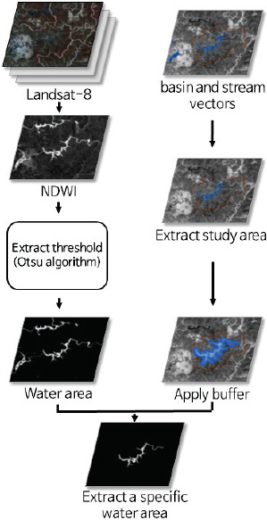
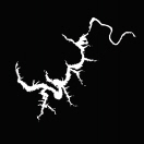
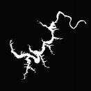
мҲҳкі„л©ҙм Ғ ліҖнҷ”нғҗм§Җ м•Ңкі лҰ¬мҰҳмқҖ м „мІҳлҰ¬, Landsat-8 мң„м„ұмҳҒмғҒмқ„ мқҙмҡ©н•ң м •к·ңмҲҳ분м§ҖмҲҳ мӮ°м¶ң, Otsu мқҙ진нҷ” м•Ңкі лҰ¬мҰҳ м Ғмҡ©, к·ёлҰ¬кі мҲҳкі„ мҳҒм—ӯ л§ҲмҠӨнӮ№мңјлЎң лӮҳлҲ„м–ҙ진лӢӨ. лЁјм Җ, м •к·ңмҲҳ분м§ҖмҲҳ мӮ°м¶ңмқҖ мң„м„ұмҳҒмғҒмқҳ к°ҖмӢңкҙ‘кіј к·јм Ғмҷё нҢҢмһҘлҢҖ мҳҒм—ӯмқҳ нҢҢмһҘм •ліҙлҘј мқҙмҡ©н•ҳм—¬ мҳҒмғҒ лӮҙ к°Ғ нҷ”мҶҢк°Җ нҸ¬н•Ён•ҳкі мһҲлҠ” мҲҳ분лҹүмқ„ нҢҢм•…н•ҳкё° мң„н•ҙ мӮ¬мҡ©лҗңлӢӨ. к·ёлҰ¬кі Otsu мқҙ진нҷ” м•Ңкі лҰ¬мҰҳмқҖ мҳҒмғҒ лӮҙ м§Җн‘ңл©ҙкіј мҲҳкі„м§Җм—ӯмқҳ 분лҘҳм—җ мӮ¬мҡ©лҗңлӢӨ. л§Ҳм§Җл§үмңјлЎң мҲҳкі„ мҳҒм—ӯ л§ҲмҠӨнӮ№мқ„ нҶөн•ҙм„ң мҲҳкі„ л©ҙм Ғмқ„ нҢҢм•…н• мҲҳ мһҲлӢӨ. Fig. 1мқҖ мҲҳкі„л©ҙм Ғ ліҖнҷ”нғҗм§Җ м•Ңкі лҰ¬мҰҳмқҳ нқҗлҰ„лҸ„лҘј лӮҳнғҖлӮёлӢӨ.
2.1 м „мІҳлҰ¬(Preprocessing)
мң„м„ұмҳҒмғҒмқҖ мқјл°ҳ мӮ¬м§„кіј лӢ¬лҰ¬ лі„лҸ„мқҳ мһ‘м—…мқ„ мІҳлҰ¬н•ң нӣ„ нҷңмҡ©н• мҲҳ мһҲлӢӨ. мқҙлҘј м „мІҳлҰ¬ кіјм •мқҙлқјкі н•ңлӢӨ. Landsat мң„м„ұмҳҒмғҒмқҖ м ңкіө мӢңм—җ кё°н•ҳліҙм •мқҙ мҲҳн–үлҗҳкё° л•Ңл¬ём—җ ліё м—°кө¬м—җм„ңлҠ” нҷ”мҶҢк°’(Digital Number, DN)м—җм„ң ліөмӮ¬нңҳлҸ„(Radiance)лЎң ліҖнҷҳкіј ліөмӮ¬нңҳлҸ„м—җм„ң лҢҖкё° мғҒл¶Җ л°ҳмӮ¬лҸ„(Top Of Atmospheric Reflectance)лЎң ліҖнҷҳмқ„ н•ҳмҳҖлӢӨ. лЁјм Җ нҷ”мҶҢк°’м—җм„ң ліөмӮ¬нңҳлҸ„лЎңмқҳ ліҖнҷҳмқҖ Eq. (1)мқҙкі , ліөмӮ¬нңҳлҸ„м—җм„ң лҢҖкё° мғҒл¶Җ л°ҳмӮ¬лҸ„мқҳ ліҖнҷҳмқҖ Eq. (2)мқҙлӢӨ(Chander and Markham, 2003; Lee et al., 2015b).
Eq. (1)м—җм„ң LО» лҠ” ліөмӮ¬нңҳлҸ„, gain мқҖ ліөмӮ¬нңҳлҸ„лЎңмқҳ ліҖнҷҳмқ„ мң„н•ң нҠ№м • нҢҢмһҘм •ліҙмқҳ кё°мҡёкё°к°’, bias лҠ” ліөмӮ¬нңҳлҸ„лЎңмқҳ ліҖнҷҳмқ„ мң„н•ң нҠ№м • нҢҢмһҘм •ліҙмқҳ нҺём°Ёк°’, к·ёлҰ¬кі DN мқҖ к°Ғ нҷ”мҶҢк°’мқ„ мқҳлҜён•ңлӢӨ. Gain кіј bias лҠ” Landsat-8 мң„м„ұмҳҒмғҒмқҳ м·Ёл“қ мӢң нҸ¬н•Ёлҗҳм–ҙ мһҲлҠ” л©”нғҖлҚ°мқҙн„° мһҗлЈҢм—җм„ң м°ҫмқ„ мҲҳ мһҲлӢӨ.
Eq. (2)м—җм„ңПҒP лҠ” лҢҖкё° мғҒл¶Җ л°ҳмӮ¬лҸ„, LО» лҠ” ліөмӮ¬нңҳлҸ„, ESUNО» лҠ” мҷёкё°к¶Ңм—җм„ңмқҳ нҸүк· мқјмӮ¬лҹү, к·ёлҰ¬кі Оёs лҠ” нғңм–‘мІңм •к°Ғмқ„ мқҳлҜён•ңлӢӨ. ESUNО» мқҳ кІҪмҡ°, Gueymard(1995)мқҳ мһҗлЈҢлҘј мқҙмҡ©н•ҳмҳҖкі , нғңм–‘мІңм •к°ҒмқҖ Landsat-8мң„м„ұмҳҒмғҒмқҳ л©”нғҖлҚ°мқҙн„° мһҗлЈҢм—җм„ң нҡҚл“қн•ҳмҳҖлӢӨ.
2.2 м •к·ңмҲҳ분м§ҖмҲҳ(NDWI)
м •к·ңмҲҳ분м§ҖмҲҳлҠ” л¬јкіј кҙҖл Ёлҗң м§ҖмҲҳлЎңмҚЁ м Ғм–ҙлҸ„ л‘җ к°ңмқҳ мң„м„ұмҳҒмғҒ нҢҢмһҘм •ліҙлҘј мқҙмҡ©н•ҳм—¬ мғқм„ұлҗңлӢӨ. м •к·ңмҲҳ분м§ҖмҲҳлҠ” к·јм ҒмҷёмҷҖ лӢЁнҢҢмһҘм ҒмҷёлҘј мқҙмҡ©н•ң Gao(1996)мҷҖ к°ҖмӢңкҙ‘кіј к·јм Ғмҷё нҢҢмһҘмқ„ мқҙмҡ©н•ң McFeeters(1996)к°Җ мһҲлӢӨ. Gao(1996)мқҳ м •к·ңмҲҳ분м§ҖмҲҳлҠ” мӢқмғқм—җ нҸ¬н•ЁлҗҳлҠ” мҲҳ분 н•Ёмң лҹүмқҳ ліҖнҷ”лҘј нҢҢм•…н•ҳлҠ”лҚ° мӮ¬мҡ©лҗңлӢӨ. л°ҳлҢҖлЎң McFeeters(1996)мқҳ м •к·ңмҲҳ분м§ҖмҲҳлҠ” м§Җн‘ңл©ҙмқҳ мҲҳ분 н•Ёмң лҹүкіј кҙҖкі„к°Җ мһҲкё° л•Ңл¬ём—җ, ліё м—°кө¬м—җм„ңлҠ” McFeeters(1996)мқҳ м •к·ңмҲҳ분м§ҖмҲҳмқё Eq. (3)мқ„ мӮ¬мҡ©н•ҳмҳҖлӢӨ.
Eq. (3)м—җм„ңПғGreen мқҖ л…№мғү нҢҢмһҘ мҳҒм—ӯлҢҖмқҳ ліөмӮ¬нңҳлҸ„ нҳ№мқҖ лҢҖкё° мғҒл¶Җ л°ҳмӮ¬лҸ„, к·ёлҰ¬кі ПғNIR мқҖ к·јм Ғмҷё нҢҢмһҘ мҳҒм—ӯлҢҖмқҳ ліөмӮ¬нңҳлҸ„ нҳ№мқҖ лҢҖкё° мғҒл¶Җ л°ҳмӮ¬лҸ„лҘј мқҳлҜён•ңлӢӨ.
2.3 Otsu мқҙ진нҷ” м•Ңкі лҰ¬мҰҳ
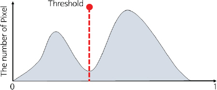
Otsu(1979)м—җ мқҳн•ҙ м ңм•Ҳлҗң мқҙ진нҷ” м•Ңкі лҰ¬мҰҳмқҖ нһҲмҠӨнҶ к·ёлһЁ нҳ•нғңк°Җ мҢҚлҙүнҳ•мқҙлқјлҠ” к°Җм •н•ҳм—җ к·№мҶҢм җмқ„ м°ҫм•„ к·ё м җмқ„ мһ„кі„к°’мңјлЎң м •н•ҳлҠ” л°©лІ•мқҙлӢӨ(Fig. 2). мҰү, м–ҙл–Ө 집합мқ„ л‘җ л¶ҖлҘҳлЎң лӮҳлҲҢ л•Ң мғҒлҢҖм ҒмңјлЎң м№ҳмҡ°міҗ мһҲлҠ” л¶Җ분л“ӨмқҖ к°ҷмқҖ л¶ҖлҘҳлЎң 분лҘҳн•ҳлҠ” л°©лІ•мқҙлӢӨ. мқҙ м•Ңкі лҰ¬мҰҳмқҖ нҶөкі„н•ҷм Ғмқё л°©лІ•мқ„ нҸ¬н•Ён•ҳкі мһҲкі , нҒҙлһҳмҠӨ лӮҙ 분мӮ°, нҒҙлһҳмҠӨ мӮ¬мқҙмқҳ 분мӮ°мңјлЎң м Ғм Ҳн•ң мһ„кі„к°’мқ„ мӮ°м¶ңн• мҲҳ мһҲлӢӨ. Eqs. (4)мҷҖ (5)лҠ” к°Ғк°Ғ нҒҙлһҳмҠӨ лӮҙ 분мӮ°кіј нҒҙлһҳмҠӨ мӮ¬мқҙмқҳ 분мӮ°мқ„ мқҳлҜён•ңлӢӨ.
Eqs. (4)мҷҖ (5)м—җм„ң wлҠ” к°ҖмӨ‘м№ҳ к°’мңјлЎң нҶөкі„н•ҷм ҒмңјлЎң t н”Ҫм…Җ к°’мқҙ лӮҳнғҖлӮ нҷ•лҘ мқ„ мқҳлҜё, Пғ i 2
2.4 мҳҒм—ӯ л§ҲмҠӨнӮ№
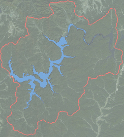
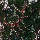
мң„м„ұмҳҒмғҒл§ҢмңјлЎңлҠ” м—°кө¬м§Җм—ӯ лӮҙ ліҖнҷ” нғҗм§ҖлҘј нҢҢм•…н•ҳкі мһҗ н•ҳлҠ” мҲҳкі„м§Җм—ӯмқҳ 추м¶ңмқҙ м–ҙл өлӢӨ. л”°лқјм„ң мҲҳкі„мҳҒм—ӯмқ„ лӮҳнғҖлӮҙлҠ” GIS мһҗлЈҢмқҳ мӮ¬мҡ©мқҙ л¶Җк°Җм ҒмңјлЎң н•„мҡ”н•ҳлӢӨ. мқҙлҘј мң„н•ҙ ліё м—°кө¬м—җм„ңлҠ” көӯк°ҖмҲҳмһҗмӣҗкҙҖлҰ¬мў…н•©м •ліҙмӢңмҠӨн…ңм—җм„ң м ңкіөн•ҳлҠ” мң м—ӯлҸ„ л°Ҹ көӯк°Җн•ҳмІң м •ліҙлҘј мқҙмҡ©н•ҳмҳҖлӢӨ. мң м—ӯлҸ„мҷҖ көӯк°Җн•ҳмІң мһҗлЈҢлҠ” лІЎн„°лЎңмҚЁ к°Ғк°Ғ м„ (Line)кіј л©ҙ(Polygon) нҳ•нғңлЎң лҗҳм–ҙ мһҲлӢӨ. Fig. 3м—җм„ң мң м—ӯлҸ„лҠ” л№Ёк°„мғү м„ мқҙкі , көӯк°Җн•ҳмІңмқҖ нҢҢлһҖмғү л©ҙмқҙлӢӨ. нҠ№м • мң м—ӯм—җ лҢҖн•ң кІҪкі„лҘј м„ м •н•ҳкё° мң„н•ҙ мң м—ӯлҸ„лҘј мӮ¬мҡ©н•ҳмҳҖкі , н•ҙлӢ№ мң м—ӯ м•Ҳмқҳ н•ҳмІң м§Җм—ӯмқ„ 추м¶ңн•ҳкё° мң„н•ҙ н•ҳмІң л””м§Җн„ё мһҗлЈҢлҘј мқҙмҡ©н•ҳмҳҖлӢӨ.
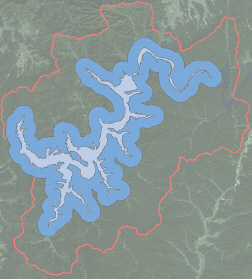
ліҖнҷ”лҘј нғҗм§Җн•ҳкі мһҗ н•ҳлҠ” мң м—ӯкіј мң м—ӯм—җ н•ҙлӢ№н•ҳлҠ” н•ҳмІң мһҗлЈҢлҘј көӯк°ҖмҲҳмһҗмӣҗкҙҖлҰ¬мў…н•©м •ліҙмӢңмҠӨн…ңм—җм„ң нҡҚл“қн•ҳмҳҖлӢӨ. н•ҙлӢ№ мң м—ӯм—җ нҸ¬н•ЁлҗҳлҠ” н•ҳмІңмһҗлЈҢлҘј 추м¶ңн•ң нӣ„, н•ҳмІң мһҗлЈҢмҷҖ мҳҒмғҒмқ„ мӨ‘мІ©н•ҳм—¬ н•ҳмІңмқҳ ліҖнҷ”лҘј нғҗм§Җн•ңлӢӨ. Fig. 3мқҳ нҢҢлһҖмғүкіј к°ҷмқҙ н•ҳмІңмһҗлЈҢлҠ” 추м¶ңмқҙ лҗңлӢӨ. н•ҳм§Җл§Ң мң„м„ұмҳҒмғҒмңјлЎң 추м¶ңлҗң н•ҳмІңм§Җм—ӯмқҙ Fig. 3мқҳ н•ҳмІң мһҗлЈҢліҙлӢӨ л©ҙм Ғмқҙ нҒҙ кІҪмҡ°м—җлҠ” нғҗм§Җн•ҳм§Җ лӘ»н•ҳлҠ” мҳӨлҘҳк°Җ л°ңмғқн•ңлӢӨ. мқҙлҹ° мҳӨлҘҳлҘј м ңкұ°н•ҳкё° мң„н•ҙ н•ҳмІңмһҗлЈҢм—җ лІ„нҚј(Buffer) кё°лҠҘмқ„ м Ғмҡ©н•ҳмҳҖлӢӨ. лІ„нҚјлһҖ лІЎн„° мһ…л ҘмһҗлЈҢм—җ мӮ¬мҡ©мһҗк°Җ мӣҗн•ҳлҠ” кёёмқҙ(m, km л“ұ)лҘј м Ғмҡ©н•ҳм—¬ мӮ¬мҡ©мһҗк°Җ мӣҗн•ҳлҠ” л§ҢнҒј лІ”мң„лҘј л„“нһҲлҠ” мһ‘м—…мқ„ мқҳлҜён•ңлӢӨ. лІ„нҚј кё°лҠҘмқҖ ArcGISмқҳ кё°лҠҘмқ„ мқҙмҡ©н•ҳм—¬ мӮ¬мҡ©н• мҲҳ мһҲлӢӨ. Fig. 3мқҳ нҢҢлһҖмғү л¶Җ분м—җ лІ„нҚјлҘј мӨҖлӢӨл©ҙ Fig. 4мқҳ нҢҢлһҖмғү л¶Җ분과 к°ҷ아진лӢӨ. лІ„нҚјк°Җ м Ғмҡ©лҗң н•ҳмІң м§Җм—ӯмқ„ мӮ¬мҡ©н•ңлӢӨл©ҙ н•ҳмІң л©ҙм Ғмқ„ 추м¶ң мӢңмқҳ мҳӨлҘҳлҘј мөңмҶҢнҷ” н• мҲҳ мһҲлӢӨ.
3. м—°кө¬м§Җм—ӯ л°Ҹ мһҗлЈҢ
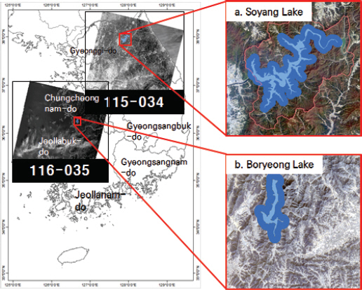
м—°кө¬м§Җм—ӯмқҖ мҶҢм–‘нҳёмҷҖ ліҙл №нҳёлЎң м„ м •н•ҳмҳҖлӢӨ. мҶҢм–‘нҳёлҠ” к°•мӣҗлҸ„ м¶ҳмІңмӢң л¶Җк·јм—җ мһҲкі , ліҙл №нҳёлҠ” 충мІӯлӮЁлҸ„ ліҙл №мӢңм—җ мң„м№ҳн•ңлӢӨ. мҶҢм–‘нҳёлҠ” мҲҳлҸ„к¶Ң м§Җм—ӯмқҳ н•өмӢ¬ мҲҳмһҗмӣҗмңјлЎң кё°лҠҘмқ„ н•ҳкі мһҲкі , ліҙл №нҳёлҠ” 충лӮЁ м„ңл¶Ғл¶Җ м§Җм—ӯмқҳ мҲҳмһҗмӣҗ кё°лҠҘмқ„ н•ҳкі мһҲлӢӨ. 2014л…„м—җм„ң 2015л…„м—җ л°ңмғқн•ң н•ңл°ҳлҸ„ к°Җлӯ„мңјлЎң мқён•ҙ мҶҢм–‘нҳёмқҳ кІҪмҡ° 1978л…„ мқҙнӣ„ л‘җ лІҲм§ёлЎң лӮ®мқҖ 152.24 mмқҳ м ҖмҲҳмң„лҘј кё°лЎқн•ҳмҳҖкі , ліҙл №нҳёлҠ” 59 mлҘј кё°лЎқн•ҳм—¬ м—°кө¬м§Җм—ӯмңјлЎң м„ м •н•ҳмҳҖлӢӨ.
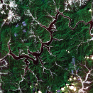
мҶҢм–‘нҳёмҷҖ ліҙл №нҳёмқҳ мӢңкі„м—ҙ ліҖнҷ”лҘј нҢҢм•…н•ҳкё° мң„н•ҙ Landsat-8 мң„м„ұмҳҒмғҒмқ„ мӮ¬мҡ©н•ҳмҳҖлӢӨ. Landsat-8 мң„м„ұмқҖ лҜёкөӯн•ӯкіөмҡ°мЈјкөӯ(National Aeronautics and Space Administration, NASA)кіј лҜёкөӯ м§Җм§ҲмЎ°мӮ¬көӯ(United States Geological Survey, USGS)м—җм„ң к°ңл°ңн•ң мң„м„ұмңјлЎң 2013л…„ 2мӣ” 11мқјм—җ л°ңмӮ¬лҗҳм–ҙ мҡҙмҡ© мӨ‘мқҙлӢӨ. Landsat-8 мң„м„ұмқҖ кіөк°„н•ҙмғҒлҸ„ 30mлҘј к°Җм§Җкі мһҲкі , лҸҷмқјн•ң м§Җм—ӯмқ„ 16мқјм—җ н•ңлІҲ м”© мһ¬л°©л¬ён•ңлӢӨ. Landsat-8м—җлҠ” OLI (Operational Land Imager)м„јм„ңмҷҖ TIR (Thermal Infrared Sensor) м„јм„ңлҘј нғ‘мһ¬н•ҳкі мһҲлӢӨ. OLIм—җлҠ” 9к°ңмқҳ нҢҢмһҘ(к°ҖмӢңкҙ‘ 5, к·јм Ғмҷё 2, мӨ‘м Ғмҷё 2)мқ„, к·ёлҰ¬кі TIRм—җлҠ” 2к°ңмқҳ м—ҙм Ғмҷё нҢҢмһҘмқ„ к°Җ진лӢӨ. ліё м—°кө¬м—җм„ңлҠ” OLI м„јм„ңлЎң нҡҚл“қлҗң, к°ҖмӢңкҙ‘ мҳҒм—ӯлҢҖмқё 2лІҲ л°ҙл“ң(0.45-0.515 Ојm)мҷҖ к·јм Ғмҷё мҳҒм—ӯмқё 5лІҲ л°ҙл“ң(0.845-0.885 Ојm)лҘј мқҙмҡ©н•ҳмҳҖлӢӨ. Fig. 5(a)мҷҖ (b)лҠ” к°Ғк°Ғ мҶҢм–‘нҳёмҷҖ ліҙл №нҳёмқҳ мң„м№ҳ л°Ҹ мӮ¬мҡ©н•ң лҚ°мқҙн„°л“Өмқ„ лӮҳнғҖлӮёлӢӨ. нҢҢлһҖмғүмңјлЎң лӮҳнғҖлӮё л¶Җ분мқҖ 90m лІ„нҚјк°Җ м Ғмҡ©лҗң н•ҳмІң л””м§Җн„ё мһҗлЈҢмқҙкі , к·ё л°‘мқҖ Landsat-8 мң„м„ұмҳҒмғҒмқҙлӢӨ. Fig. 5мқҳ 115-034мҷҖ 116-035лҠ” WRS2 (Worldwide Reference System)лЎң Landsat-8 мң„м„ұмҳҒмғҒмқ„ м§Җм—ӯлі„лЎң 분лҘҳн•ҳлҠ” лІҲнҳёлҘј лӮҳнғҖлӮёлӢӨ.
мҶҢм–‘нҳёмҷҖ ліҙл №нҳёмқҳ мҲҳкі„л©ҙм Ғ ліҖнҷ”лҘј нҢҢм•…н•ҳкё° мң„н•ҙ 2014л…„м—җм„ң 2015л…„к№Ңм§Җ мҙ¬мҳҒлҗң Landsat-8 мң„м„ұмҳҒмғҒмқ„ мқҙмҡ©н•ҳмҳҖлӢӨ. Landsat-8 мң„м„ұмҳҒмғҒмқҖ USGS (https://earthexplorer.usgs.gov/)м—җм„ң л¬ҙлЈҢлЎң мӮ¬мҡ©к°ҖлҠҘн•ҳлӢӨ. Landsat-8 мң„м„ұмҳҒмғҒмқҳ м·Ёл“қ мӢң н’Ҳм§Ҳмқҙ мўӢмқҖ(кө¬лҰ„мқҙ нҸ¬н•Ёлҗҳм§Җ м•ҠмқҖ) мҳҒмғҒл“Өмқ„ м„ лі„н•ҳм—¬ мқҙмҡ©н•ҳмҳҖлӢӨ. мҶҢм–‘нҳёмҷҖ ліҙл №нҳё м§Җм—ӯмқҙ мҙ¬мҳҒлҗң мҙқ 12мһҘмқҳ мң„м„ұмҳҒмғҒмқ„ лӢӨмҡҙлЎңл“ң н•ҳмҳҖлӢӨ. мҶҢм–‘нҳёмҷҖ ліҙл №нҳёк°Җ мҙ¬мҳҒлҗҳлҠ” Landsat-8 мң„м„ұмҳҒмғҒмқҳ мҳҒм—ӯмқҙ лӢӨлҘҙкё° л•Ңл¬ём—җ лҸҷмқјн•ң мӢңкё°мқҳ мҳҒмғҒмқҖ мӮ¬мҡ©н• мҲҳ м—ҶлӢӨ. мҶҢм–‘нҳёмҷҖ ліҙл №нҳёлҘј мҙ¬мҳҒн•ң мҙқ 12мһҘмқҳ мң„м„ұмҳҒмғҒм—җ м „мІҳлҰ¬, м •к·ңмҲҳ분м§ҖмҲҳ, Otsu мқҙ진нҷ” м•Ңкі лҰ¬мҰҳ, к·ёлҰ¬кі мҳҒм—ӯ л§ҲмҠӨнӮ№мқ„ м Ғмҡ©н•ҳмҳҖкі , мҳҒм—ӯ л§ҲмҠӨнӮ№мңјлЎң м ңмһ‘н•ң 90 m лІ„нҚј л””м§Җн„ё мһҗлЈҢ м•Ҳм—җ нҸ¬н•Ёлҗң мҲҳкі„м§Җм—ӯл“Өмқ„ 추м¶ңн•ҳмҳҖлӢӨ. м—¬кё°м„ң, 추м¶ңн•ң мҲҳкі„м§Җм—ӯмқҖ нҷ”мҶҢмқҳ к°ңмҲҳлЎң лӮҳнғҖлӮҙкё° л•Ңл¬ём—җ нҷ”мҶҢ к°ңмҲҳмҷҖ кіөк°„н•ҙмғҒлҸ„лҘј кіұн•ҳм—¬ мҲҳкі„ л©ҙм Ғмқ„ 추м¶ңн•ҳмҳҖлӢӨ.
4. кІ°кіј л°Ҹ кі м°°
4.1 мҶҢм–‘нҳёмҷҖ ліҙл №нҳёмқҳ мҲҳкі„л©ҙм Ғ ліҖнҷ” л°Ҹ кІҖмҰқ
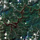
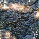
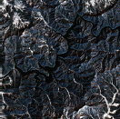
мҶҢм–‘нҳёмҷҖ ліҙл №нҳёмқҳ мҲҳкі„л©ҙм Ғ ліҖнҷ” нҢҢм•…мқ„ мң„н•ҙ мӮ¬мҡ©лҗң мң„м„ұмҳҒмғҒ, 추м¶ңлҗң мҲҳкі„л©ҙм Ғ, к·ёлҰ¬кі к°Ғ мң„м„ұмҳҒмғҒмқҳ мҙ¬мҳҒ мӢңкё°лҠ” Tables 1кіј 2м—җ лӮҳнғҖлӮҙм—ҲлӢӨ. Table 1мқҖ мҶҢм–‘нҳёмқҳ мӢңкі„м—ҙ мҲҳкі„ л©ҙм Ғ ліҖнҷ”мқҙкі , Table 2лҠ” ліҙл №нҳёмқҳ мӢңкі„м—ҙ мҲҳкі„ л©ҙм Ғ ліҖнҷ”мқҙлӢӨ. Tables 1кіј 2м—җм„ң 컬лҹ¬мҳҒмғҒмқҖ мң„м„ұмҳҒмғҒмқҳ к°ҖмӢңкҙ‘ нҢҢмһҘлҢҖмқё 2, 3, к·ёлҰ¬кі 4лІҲ л°ҙл“ңлҘј мЎ°н•©н•ҙм„ң лӮҳнғҖлӮҙм—ҲлӢӨ. л”°лқјм„ң м№ҙл©”лқјлЎң мҙ¬мҳҒлҗң мӮ¬м§„кіјлҠ” мғүк°җмқҙ лӢӨлҘҙкІҢ ліҙмқј мҲҳ мһҲлӢӨ.
TableВ 1
Change of Time-series Water Area in the Soyang Lake


TableВ 2
Change of Time-series Water Area in the Boryeong Lake


мҶҢм–‘нҳёмқҳ мӢңкі„м—ҙ мҲҳкі„ л©ҙм Ғ ліҖнҷ”лҘј нҢҢм•…н•ҳкё° мң„н•ҙ 2014л…„ 10мӣ”л¶Җн„° 2015л…„ 5мӣ”к№Ңм§Җ мҙ¬мҳҒлҗң мҙқ 6мһҘмқҳ Landsat-8 мң„м„ұмҳҒмғҒмқ„ мӮ¬мҡ©н•ҳмҳҖлӢӨ. Table 1кіј к°ҷмқҙ мҶҢм–‘нҳёмқҳ мҲҳкі„ л©ҙм Ғмқ„ 추м¶ңн•ң кІ°кіј, мҶҢм–‘нҳёк°Җ к°ҖмһҘ лӮ®мқҖ мӢңкё°лҠ” 2015л…„ 5мӣ” 10мқјлЎң 21.50 km2мқҳ мҲҳкі„ л©ҙм Ғмқ„ ліҙмҳҖлӢӨ. к·ёлҰ¬кі мҲҳкі„ л©ҙм Ғмқҙ к°ҖмһҘ лҶ’мқҖ мӢңкё°лҠ” 2015л…„ 1мӣ” 2мқјлЎң 32.29 km2лҘј лӮҳнғҖлғҲлӢӨ. Table 1кіј к°ҷмқҙ кІЁмҡёмӢңкё°м—җ мҲҳкі„ л©ҙм Ғмқҙ лӢӨлҘё мӢңкё°ліҙлӢӨ лҶ’мқҖ кІғмқ„ нҷ•мқён• мҲҳ мһҲлҠ”лҚ°, мқҙлҠ” лӢӨлҘё н”јліөмқҙ мҲҳкі„ л©ҙм ҒмңјлЎң нҸ¬н•Ёлҗҳм—Ҳкё° л•Ңл¬ёмңјлЎң нҢҗлӢЁлҗңлӢӨ. мҶҢм–‘нҳё мЈјліҖ м§Җм—ӯмқ„ л¶Җ분м ҒмңјлЎң нҷ•мқён•ҙліё кІ°кіј, мӮ°м§Җ м§Җм—ӯм—җм„ң л°ңмғқн•ҳлҠ” к·ёлҰјмһҗ мҳҒм—ӯмқҳ нҷ”мҶҢк°’мқҙ мҲҳкі„ м§Җм—ӯмқҳ нҷ”мҶҢк°’кіј мң мӮ¬н•ң к°’мңјлЎң лӮҳнғҖлӮ¬лӢӨ. мқҙлҹ° мқҙмң лЎң мӮ°м§Җмқҳ к·ёлҰјмһҗ м§Җм—ӯмқҙ л¬јлЎң 추м¶ңлҗҳм–ҙ мҲҳкі„ мҳҒм—ӯм—җ нҸ¬н•Ёлҗң кІғмңјлЎң нҢҗлӢЁлҗңлӢӨ. кІЁмҡё мӢңкё°мқҳ мҳҒмғҒмқ„ м ңмҷён•ң лӢӨлҘё мҳҒмғҒл“Өмқҳ мҲҳкі„л©ҙм Ғ ліҖнҷ” м–‘мғҒмқ„ нҢҢм•…н•ҙліё кІ°кіј, 2014л…„ 10мӣ”м—җ 26.96 km2м—җм„ң 2015л…„ 5мӣ”м—җ 21.82 km2лЎң 5.14 km2мқҳ мҲҳкі„ л©ҙм Ғмқҙ мӨ„м–ҙл“ кІғмңјлЎң лӮҳнғҖлӮ¬лӢӨ.
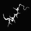
ліҙл №нҳёмқҳ мӢңкі„м—ҙ мҲҳкі„ л©ҙм Ғ ліҖнҷ”лҘј нҢҢм•…н•ҳкё° мң„н•ҙ 2014л…„ 9мӣ”л¶Җн„° 2015л…„ 12мӣ”к№Ңм§Җ мҙ¬мҳҒлҗң мҙқ 6мһҘмқҳ мң„м„ұмҳҒмғҒмқ„ мӮ¬мҡ©н•ҳмҳҖлӢӨ. Table 2м—җм„ң мҙқ 6мһҘмқҳ мң„м„ұмҳҒмғҒ мӨ‘ 2015л…„ 9мӣ” 22мқјмқҳ кІҪмҡ°, мңЎм•ҲмңјлЎң нҢҢм•…н• мҲҳ мһҲлҠ” мҲҳкі„ мҳҒм—ӯкіј ліё м—°кө¬мқҳ м•Ңкі лҰ¬мҰҳмңјлЎң 추м¶ңн•ң мҲҳкі„ мҳҒм—ӯм—җм„ң м°Ёмқҙк°Җ мһҲм—ҲлӢӨ. мқҙлҠ” н•ҙлӢ№ мӢңкё°мқҳ мң„м„ұмҳҒмғҒ лӮҙм—җм„ң л°ңмғқн•ң мҳӨлҘҳм—җ мқҳн•ҙ нҠ№м • м§Җм—ӯмқҙ мҲҳкі„ мҳҒм—ӯмңјлЎң 분лҘҳк°Җ лҗҳм§Җ м•Ҡм•ҳлӢӨ. 2015л…„ 12мӣ” 27мқјм—җ 추м¶ңлҗң мҲҳкі„л©ҙм ҒмқҖ мҶҢм–‘нҳёмқҳ мҲҳкі„ 추м¶ң кІ°кіјмҷҖ к°ҷмқҙ мӮ°м§Җ м§Җм—ӯмқҳ к·ёлҰјмһҗк°Җ мҲҳкі„м§Җм—ӯмңјлЎң мҳӨ분лҘҳлҗҳм–ҙ кіјлҢҖ м¶”м •лҗң кІ°кіјлҘј ліҙмҳҖлӢӨ. Table 2мҷҖ к°ҷмқҙ ліҙл №нҳёмқҳ мҲҳкі„ л©ҙм Ғмқ„ 추м¶ңн•ң кІ°кіј, ліҙл №нҳёмқҳ мҲҳкі„ л©ҙм Ғмқҙ к°ҖмһҘ лӮ®мқҖ мӢңкё°лҠ” 2015л…„ 9мӣ” 22мқјлЎң м•Ҫ 2.23 km2лЎң мӮ°м¶ңлҗҳм—Ҳкі , к°ҖмһҘ лҶ’мқҖ мӢңкё°лҠ” 2015л…„ 4мӣ” 15мқјлЎң м•Ҫ 3.5 km2мқҳ л©ҙм Ғмқ„ ліҙмҳҖлӢӨ. м „л°ҳм Ғмқё кІҪн–ҘмңјлЎңлҠ” 2014л…„ 9мӣ”л¶Җн„° 2015л…„ 4мӣ”к№Ңм§Җ мҲҳкі„л©ҙм Ғмқҙ мғҒмҠ№н•ҳлҠ” 추세лҘј ліҙмқҙкі , 2015л…„ 7мӣ”л¶Җн„°лҠ” лӢӨмҶҢ н•ҳлқҪн•ҳлӢӨк°Җ 2015л…„ 12мӣ”м—җ лӢӨмӢң мғҒмҠ№н•ҳлҠ” кІҪн–Ҙмқ„ ліҙмқёлӢӨ. м „л°ҳм ҒмңјлЎңлҠ” 2014л…„ 9мӣ”м—җ 비н•ҙ 2015л…„ 9мӣ”м—җ м•Ҫ 0.81 km2мқҳ мҲҳкі„л©ҙм Ғмқҙ к°җмҶҢн•ң кІғмңјлЎң лӮҳнғҖлӮ¬лӢӨ.
Tables 1кіј 2мқҳ мң„м„ұмҳҒмғҒмңјлЎң 추м¶ңн•ң мҲҳкі„л©ҙм Ғмқҳ кІҖмҰқмқ„ мң„н•ҙ көӯк°ҖмҲҳмһҗмӣҗкҙҖлҰ¬мў…н•©м •ліҙмӢңмҠӨн…ң(Water Resources Management Information System)м—җм„ң м ңкіөн•ҳлҠ” лҢҗмқҳ м ҖмҲҳмң„ мһҗлЈҢлҘј нҷңмҡ©н•ҳмҳҖлӢӨ. мҶҢм–‘лҢҗкіј ліҙл №лҢҗмқҳ лҢҗмҲҳл¬ёмһҗлЈҢ(мқјмһҗлЈҢ)лҘј мқҙмҡ©н•ҳмҳҖкі , мҲҳкі„ л©ҙм Ғкіј м ҖмҲҳмң„ мһҗлЈҢмқҳ мғҒкҙҖкі„мҲҳ(R)лҘј мӮ°м¶ңн•ҳмҳҖлӢӨ. мҶҢм–‘лҢҗкіј ліҙл №лҢҗмқҳ м ҖмҲҳмң„ мһҗлЈҢлҠ” Tables 1кіј 2м—җ мһҲкі , Figs. 6кіј 7мқҖ к°Ғк°Ғ мҶҢм–‘нҳёмҷҖ ліҙл №нҳёмқҳ мҲҳкі„ л©ҙм Ғ л°Ҹ м ҖмҲҳмң„ ліҖнҷ”лҘј лӮҳнғҖлӮёлӢӨ. Figs. 6кіј 7м—җм„ң нҢҢлһҖмғү л§үлҢҖлҠ” Landsat-8 мң„м„ұмҳҒмғҒм—җм„ң 추м¶ңн•ң мҲҳкі„л©ҙм Ғмқ„ лӮҳнғҖлӮҙкі , л№Ёк°„мғү м„ к·ёлһҳн”„лҠ” м ҖмҲҳмң„ мһҗлЈҢлҘј лӮҳнғҖлӮёлӢӨ. Fig. 6мқё мҶҢм–‘нҳёмқҳ кІҪмҡ°м—җлҠ” кІЁмҡё мӢңкё°лҘј м ңмҷён•ҳл©ҙ м „л°ҳм Ғмқё м–‘мғҒмқҖ мң мӮ¬н•ң кІғмңјлЎң нҢҗлӢЁлҗңлӢӨ. кІЁмҡё мӢңкё°лҘј нҸ¬н•Ён•ң мғҒкҙҖкі„мҲҳ(R)лҠ” 0.79мҳҖкі , кІЁмҡёмӢңкё°лҘј м ңмҷён•ңлӢӨл©ҙ 0.97к№Ңм§Җ мғҒмҠ№н•ҳмҳҖлӢӨ. Fig. 7мқё ліҙл №нҳёмқҳ кІҪмҡ° 0.83мқҳ мғҒкҙҖкі„мҲҳ(R)лҘј ліҙмҳҖлӢӨ.
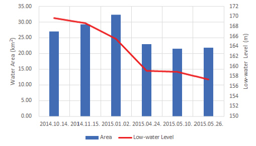

м•һм„ң м–ёкёүлҗң кІғкіј к°ҷмқҙ Fig. 6м—җм„ң 2014л…„ 11мӣ” 15мқјкіј 2015л…„ 1мӣ” 2мқјм—җ 추м¶ңлҗң мҲҳкі„ л©ҙм ҒмқҖ м ҖмҲҳмң„ мһҗлЈҢмҷҖ кІҪн–Ҙмқҙ лҸҷмқјн•ҳм§Җ м•Ҡм•ҳлӢӨ. мқҙлҹ° л¶Җ분мқҖ Fig. 7мқҳ 2015л…„ 12мӣ” 27мқјм—җлҸ„ ліҙмҳҖлӢӨ. н•ҙлӢ№ л¬ём ңм җл“Өмқ„ н•ҙкІ°н•ҳкё° мң„н•ҙм„ңлҠ” нҶ м§Җн”јліөлҸ„лҘј мқҙмҡ©н•ң мӮ°м§Җ м ңкұ° лҳҗлҠ” м •к·ң мҲҳ분м§ҖмҲҳ мҷёмқҳ лӢӨлҘё мӣҗкІ©нғҗмӮ¬ м§ҖмҲҳл“Өмқ„ мңөн•©н•ҳм—¬ м •нҷ•н•ң мҲҳкі„ м§Җм—ӯмқҳ 추м¶ңмқҙ н•„мҡ”н• кІғмңјлЎң нҢҗлӢЁлҗңлӢӨ. мң„мқҳ л¬ём ңм җл“Өмқ„ н•ҙкІ°н•ңлӢӨл©ҙ ліҙлӢӨ м •нҷ•н•ң мҲҳкі„ л©ҙм Ғмқ„ нҢҢм•…н• мҲҳ мһҲмқ„ кІғмңјлЎң мӮ¬лЈҢлҗңлӢӨ.
4.2 мҶҢм–‘нҳёмҷҖ ліҙл №нҳёмқҳ лҸҷмқјмӢңкё° мҲҳкі„ л©ҙм Ғ ліҖнҷ” 비көҗ
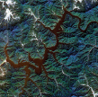
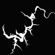
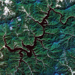
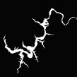
мҶҢм–‘нҳёмҷҖ ліҙл №нҳём—җм„ң лҸҷмқјмӢңкё° лҢҖ비 мҲҳкі„ л©ҙм Ғ ліҖнҷ”лҘј нҢҢм•…н•ҳмҳҖлӢӨ. мҙ¬мҳҒлҗң мң„м„ұмҳҒмғҒмқҳ н’Ҳм§ҲлЎң мқён•ҙ мҶҢм–‘нҳёлҠ” 2013л…„ 10мӣ”, 2014л…„ 10мӣ”, к·ёлҰ¬кі 2015л…„ 10мӣ”м—җ мҙ¬мҳҒлҗң мң„м„ұмҳҒмғҒл“Өмқ„ мқҙмҡ©н•ҳмҳҖлӢӨ. ліҙл №нҳёмқҳ кІҪмҡ°, н’Ҳм§Ҳмқҙ лҶ’кІҢ мҙ¬мҳҒлҗң 10мӣ” мҳҒмғҒл“Өмқҙ л¶ҖмЎұн–Ҳкё°м—җ 2013л…„л¶Җн„° 2015л…„мқҳ 9мӣ” мҳҒмғҒл“Өмқ„ мӮ¬мҡ©н•ҳмҳҖлӢӨ. мҶҢм–‘нҳёмҷҖ ліҙл №нҳёмқҳ лҸҷмқјмӢңкё° 분м„қмқ„ мң„н•ҙ мӮ¬мҡ©н•ң мң„м„ұмҳҒмғҒкіј мң„м„ұмҳҒмғҒмңјлЎң 추м¶ңн•ң мҲҳкі„ мҳҒм—ӯ л°Ҹ л©ҙм Ғ, к·ёлҰ¬кі н•ҙлӢ№ мӢңкё°мқҳ м ҖмҲҳмң„ мһҗлЈҢм—җ кҙҖн•ң м •ліҙлҠ” Tables 3кіј 4м—җ лӮҳнғҖлӮҙм—ҲлӢӨ.
TableВ 3
Comparison of Water Area at the Same Month (October) in Soyang Lake
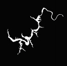
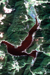
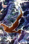
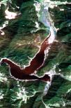
| Satellite Imagery | Imagery of Water Area | Area (km2) | LWL (m) | |
|---|---|---|---|---|
| 2013. 10.27. |
|
|
32.44 | 185.98 |
| 2014. 10.14. |

|
|
26.96 | 169.73 |
| 2015. 10.17. |
|
|
26.98 | 169.10 |
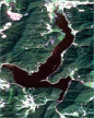
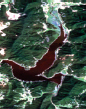
TableВ 4
Comparison of Water Area at the Same Month (September) in Boryeong Lake
| Satellite Imagery | Imagery of Water Area | Area (km2) | LWL (m) | |
|---|---|---|---|---|
| 2013. 09.16. |
|

|
4.31 | 72.89 |
| 2014. 09.19. |
|

|
3.35 | 64.27 |
| 2015. 09.22. |

|

|
2.54 | 59.45 |
мң„м„ұмҳҒмғҒмқ„ мқҙмҡ©н•ҙ мҶҢм–‘нҳёмқҳ мҲҳкі„л©ҙм Ғмқ„ мӮ°м¶ңн•ң кІ°кіј, 2013л…„м—җ 비н•ҙ 2015л…„ 10мӣ”м—җлҠ” м•Ҫ 5.5 km2к°Җ к°җмҶҢлҗҳм—ҲлӢӨ. н•ҳм§Җл§Ң 2014л…„кіј 2015л…„мқ„ 비көҗн–Ҳмқ„ л•Ң, 2015л…„м—җлҠ” 0.02 km2лЎң м•ҪмҶҢн•ң мҰқк°Җк°Җ мһҲм—ҲлӢӨ. ліҙл №нҳёмқҳ кІҪмҡ°м—җлҠ” 2013л…„ лҢҖ비 2015л…„м—җ 1.8 km2мқҳ мҲҳкі„ л©ҙм Ғ к°җмҶҢк°Җ мһҲм—Ҳкі , 2014л…„ лҢҖ비лЎңлҠ” 0.81km2мқҳ к°җмҶҢк°Җ ліҙмҳҖлӢӨ. мқҙлҹ° кІ°кіјлҠ” н•ҙлӢ№мӢңкё°мқҳ м§Ғм ‘ мёЎм •лҗң м ҖмҲҳмң„ мһҗлЈҢмҷҖ лҸҷмқјн•ң кІҪн–Ҙмқ„ лӮҳнғҖлӮҙм—ҲлӢӨ. мҶҢм–‘нҳёмқҳ кІҪмҡ° 2013л…„лҢҖ비 2015л…„м—җ 16.88 mмқҳ м ҖмҲҳмң„ к°җмҶҢк°Җ ліҙмҳҖкі , ліҙл №нҳёмқҳ кІҪмҡ°м—җлҠ” 13.44 mмқҳ к°җмҶҢк°Җ ліҙмҳҖлӢӨ. мқҙлҹ° 추세лҠ” 2014л…„кіј 2015л…„ н•ңл°ҳлҸ„м—җ л°ңмғқн•ң к°Җлӯ„мқҳ мӢ¬к°Ғм„ұмқ„ лҢҖліҖн•ңлӢӨкі нҢҗлӢЁлҗңлӢӨ.
5. кІ°лЎ
ліё м—°кө¬лҠ” Landsat-8 мң„м„ұмҳҒмғҒмқ„ мқҙмҡ©н•ҳм—¬ нҠ№м • мҲҳкі„ л©ҙм Ғмқҳ нҢҢм•…мқ„ лӘ©м ҒмңјлЎң н•ҳкі мһҲлӢӨ. мҲҳкі„ л©ҙм Ғмқ„ нҢҢм•…н•ҳкё° мң„н•ҙ Landsat-8 мң„м„ұмҳҒмғҒмқ„ м „мІҳлҰ¬, м •к·ңмҲҳ분м§ҖмҲҳ мӮ°м¶ң, Otsu мқҙ진нҷ” м•Ңкі лҰ¬мҰҳ м Ғмҡ©, к·ёлҰ¬кі мҳҒм—ӯ л§ҲмҠӨнӮ№ мҲңмңјлЎң 진н–үн•ҳмҳҖлӢӨ. м „мІҳлҰ¬м—җм„ңлҠ” мң„м„ұмҳҒмғҒмқҳ нҷ”мҶҢк°’мқ„ лҢҖкё° мғҒл¶Җ л°ҳмӮ¬лҸ„лЎң ліҖнҷҳн•ҳмҳҖкі , м •к·ңмҲҳ분м§ҖмҲҳмҷҖ Otsu мқҙ진нҷ” м•Ңкі лҰ¬мҰҳмқ„ нҶөн•ҙ м§ҖмғҒкіј мҲҳкі„м§Җм—ӯмқ„ кө¬л¶„н•ҳмҳҖлӢӨ. к·ёлҰ¬кі мҳҒм—ӯ л§ҲмҠӨнӮ№м—җм„ңлҠ” н•ҳмІң л””м§Җн„ё мһҗлЈҢлҘј мқҙмҡ©н•ҳм—¬ Landsat-8 мң„м„ұмҳҒмғҒмқҳ нҠ№м • мҲҳкі„ м§Җм—ӯмқ„ 추м¶ңн•ҳлҠ”лҚ° мқҙмҡ©н•ҳмҳҖлӢӨ. мӢӨн—ҳмқҖ 2014л…„кіј 2015л…„м—җ мҙ¬мҳҒлҗң Landsat-8 мң„м„ұмҳҒмғҒмқ„ мқҙмҡ©н•ҳм—¬ мҶҢм–‘нҳёмҷҖ ліҙл №нҳёмқҳ мҲҳкі„л©ҙм Ғмқ„ мӮ°м¶ңн•ҳмҳҖлӢӨ. мҶҢм–‘нҳёмҷҖ ліҙл №нҳёмқҳ мҲҳкі„ л©ҙм Ғ мӮ°м¶ң кІ°кіј, 2014л…„ лҢҖ비 2015л…„м—җ к°Ғк°Ғ 5.14 km2мҷҖ 0.81 km2мқҳ мҲҳкі„ л©ҙм Ғмқҙ к°җмҶҢн•ң кІғмқ„ нҷ•мқён•ҳмҳҖлӢӨ. мӮ°м¶ңлҗң мҲҳкі„л©ҙм ҒмқҖ көӯк°ҖмҲҳмһҗмӣҗкҙҖлҰ¬мў…н•©м •ліҙмӢңмҠӨн…ңм—җм„ң м ңкіөн•ҳлҠ” м ҖмҲҳмң„ мһҗлЈҢмҷҖ 비көҗкІҖмҰқн•ҳмҳҖлӢӨ. к·ё кІ°кіј, мҶҢм–‘нҳёлҠ” 0.79, к·ёлҰ¬кі ліҙл №нҳёлҠ” 0.83мқҳ мғҒкҙҖкі„мҲҳ(R)лҘј лҸ„м¶ңн•ҳмҳҖлӢӨ.
кё°мЎҙ к°Җлӯ„ 분м„қ м—°кө¬л“ӨмқҖ м„јм„ң мһҗлЈҢлҘј мқҙмҡ©н•ҳкё° л•Ңл¬ём—җ м§Җм—ӯм ҒмңјлЎң көӯн•ңлҗҳм–ҙ мҷ”лӢӨ. л”°лқјм„ң мң м—ӯмқҳ мҲҳкі„ л©ҙм Ғ ліҖнҷ”лҘј нҢҢм•…н•ҳм—¬ лҚ” м •нҷ•н•ң к°Җлӯ„мқ„ нҢҢм•…н•ҳлҠ” кё°мҲ мқҙ н•„мҡ”н•ҳлӢӨ. к·ёл Үкё°м—җ ліё м—°кө¬м—җм„ң 진н–үн•ң Landsat-8 мң„м„ұмҳҒмғҒмқҳ мҲҳкі„л©ҙм Ғ 추м¶ңкё°мҲ мқҖ мң мҡ©н•ҳкІҢ мӮ¬мҡ©лҗ кІғмңјлЎң нҢҗлӢЁлҗңлӢӨ. нҠ№нһҲ л¶Ғн•ңмқҖ л¶Җм •нҷ•н•ң к°•мҲҳлҹү м •ліҙлҘј м ңкіөн•ҳкё° л•Ңл¬ём—җ н•ҙлӢ№ кё°мҲ мқ„ мӮ¬мҡ©н•ңлӢӨл©ҙ ліҙлӢӨ м •нҷ•н•ң к°Җлӯ„нҢҢм•…мқ„ н• мҲҳ мһҲмқ„ кІғмқҙлӢӨ. н–Ҙнӣ„ м—°кө¬м—җм„ңлҠ” нҶ м§Җн”јліөм§ҖлҸ„лҘј мқҙмҡ©н•ң мӮ°м§Җ м ңкұ° л°Ҹ мҲҳкі„м§Җм—ӯ 추м¶ң мӢң м •к·ңмҲҳ분м§ҖмҲҳмҷҖ л¶Җк°Җм Ғмқё мһҗлЈҢ(мҳЁлҸ„, м •к·ңмӢқмғқм§ҖмҲҳ л“ұ)л“Өмқ„ мңөн•©н•ҳл©ҙ ліё м—°кө¬м—җм„ң л°ңмғқн•ң мӮ°м§Җмқҳ к·ёлҰјмһҗм§Җм—ӯ мҳӨ분лҘҳ л“ұмқҳ л¬ём ңм җл“Өмқ„ н•ҙкІ°н• мҲҳ мһҲмқ„ кІғмңјлЎң мӮ¬лЈҢлҗңлӢӨ.


