


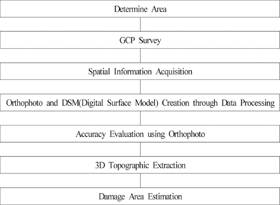
1. ņä£ļĪĀ
ņĄ£ĻĘ╝ ņØ┤ņāüĻĖ░Ēøäļ│ĆĒÖöņŚÉ ļö░ļźĖ ĻĄŁņ¦Ćņä▒ ņ¦æņżæĒśĖņÜ░ ļō▒ ĒÖŹņłśĒö╝ĒĢ┤ļĪ£ ņØĖĒĢ£ ņ×ÉņŚ░ņ×¼ĒĢ┤ Ēö╝ĒĢ┤Ļ░Ć ļ╣łļ▓łĒĢśĻ▓ī ļ░£ņāØĒĢśĻ│Ā ņ׳ļŗż. ņ×ÉņŚ░ņ×¼ĒĢ┤ Ēö╝ĒĢ┤ļĪ£ ņØĖĒĢ£ ņØĖļ¬ģĒö╝ĒĢ┤ļéś ņ×¼ņé░Ēö╝ĒĢ┤Ļ░Ć ņ”ØĻ░ĆĒĢśĻ│Ā ņ׳ļŖö ņČöņäĖņØ┤ļ®░ ļÅäņŗ£Ļ░£ļ░£ļĪ£ ņØĖĒĢ£ ļČłĒł¼ņłśņ£© ņ”ØĻ░ĆļĪ£ ņ╣©ņłśĒö╝ĒĢ┤ ļ╣łļÅäĻ░Ć ņ”ØĻ░ĆĒĢśĻ│Ā, ņ╣©ņłśņ¦ĆņŚŁņØś ĒÖĢļīĆļĪ£ ņØĖĒĢ£ ņ×¼ņé░Ēö╝ĒĢ┤Ļ░Ć ļ░£ņāØĒĢśĻ│Ā ņ׳ļŗż. ņÜ░ļ”¼ļéśļØ╝ņØś ņ×¼ĒĢ┤ņ¦ĆļÅäļŖö ņ×ÉņŚ░ņ×¼ĒĢ┤ļīĆņ▒ģļ▓Ģ ņĀ£21ņĪ░, ļÅÖļ▓Ģ ņŗ£Ē¢ēļĀ╣ ņĀ£18ņĪ░ ļ░Å ņĀ£19ņĪ░ņÖĆ ŌĆśņ×¼ĒĢ┤ņ¦ĆļÅä ņ×æņä▒ ĻĖ░ņżĆ ļō▒ņŚÉ Ļ┤ĆĒĢ£ ņ¦Ćņ╣©(National Emergency Management Agency(NEMA), 2013)ŌĆÖ ļō▒ņŚÉ ĻĘ£ņĀĢļÉśņ¢┤ņ׳ļŗż. ņØ┤ ņżæ ņ╣©ņłśĒØöņĀüļÅäļŖö Ēā£ĒÆŹ, ĒśĖņÜ░, ĒĢ┤ņØ╝ ļō▒ ĒÆŹņłśĒĢ┤ļĪ£ņØĖĒĢ£ ņ╣©ņłśĒö╝ĒĢ┤Ļ░Ć ļ░£ņāØĒĢ£ ņ¦ĆņŚŁņŚÉ ļīĆĒĢśņŚ¼ ņ╣©ņłśĒØöņĀü ņĪ░ņé¼ ļ░Å ņĖĪļ¤ēņØä ņŗżņŗ£ĒĢśĻ│Ā ņ╣©ņłśĻĄ¼ņŚŁņŚÉ ļīĆĒĢ£ ņ╣©ņłśņ£ä, ņ╣©ņłśņŗ¼, ņ╣©ņłśņŗ£Ļ░ä ļō▒ņØä ņĪ░ņé¼ĒĢśņŚ¼ ņŚ░ņåŹņ¦ĆņĀüļÅä ļ░Å ņłśņ╣śņ¦ĆĒśĢļÅä ļō▒ņŚÉ Ēæ£ņŗ£ĒĢ£ ņ¦ĆļÅäļź╝ ļ¦ÉĒĢśļ®░, ņ¦Ćļ░®ņ×Éņ╣śļŗ©ņ▓┤ļ│äļĪ£ ņĀ£ņ×æ ļ░Å ļ│┤ņĪ┤ĒĢśĻ│Ā ņ׳ļŗż. Ēśäņ×¼ņØś ņ╣©ņłśĒØöņĀüļÅäņ×æņä▒ņØĆ ņ╣©ņłśĒö╝ĒĢ┤ ļ░£ņāØ Ēøä ņ╣©ņłś Ēö╝ĒĢ┤ņ¦ĆņŚŁņØä Ēśäņ¦Ć ļ░®ļ¼ĖĒĢśņŚ¼ ņ╣©ņłśĒØöņĀü ņĪ░ņé¼ļź╝ ņŗżņŗ£ĒĢśņŚ¼ ņ×æņä▒ĒĢśĻ│Ā ņ׳ļŗż. ĻĘĖļ¤¼ļéś ņ╣©ņłśĒØöņĀüļÅäņØś ņ×æņä▒ņØĆ ņ╣©ņłśĒö╝ĒĢ┤ņØś ĒŖ╣ņä▒ņāü ņ╣©ņłśņ¦ĆņåŹņŗ£Ļ░äņØ┤ ņ¦¦ņĢä ņ┤łļÅÖņĪ░ņé¼ņŚÉ ņ¢┤ļĀżņøĆņØä Ļ▓¬Ļ│Ā ņ׳ņ£╝ļ®░, ņśłņé░ ļō▒ Ē¢ēņĀĢņĀüņØĖ ņĀłņ░©ļĪ£ ņØĖĒĢśņŚ¼ ņŗĀņåŹĒ׳ ņ¦äĒ¢ēņØ┤ ņ¢┤ļĀżņøī ņ╣©ņłśĒØöņĀüļÅäņØś ņ╣©ņłśņŗ¼Ļ│╝ ņ╣©ņłśļ▓öņ£äņŚÉ ļīĆĒĢ£ ņĀĢĒÖĢĒĢ£ ņĀĢļ│┤ļź╝ ņŖĄļōØĒĢśĻĖ░ ņ¢┤ļĀżņøī ņŗĀļó░ļÅä ņ׳ļŖö ņ╣©ņłśĒØöņĀüļÅäņØś ņ×æņä▒ņŚÉ ņןņĢĀņÜöņØĖņØ┤ ļÉśĻ│Ā ņ׳ļŗż.
Park et al. (2015)ļŖö ļ¼┤ņØĖĒĢŁĻ│ĄĻĖ░(Unmanned Aerial Vehicle,ņØ┤ĒĢś UAV)ļŖö ĻĖ░ņĪ┤ņØś ņ£äņä▒Ļ│╝ ĒĢŁĻ│Ą ņśüņāüņ£╝ļĪ£ ņ¢╗ĻĖ░ ĒלļōĀ ņØ╝ņĀĢņ¦ĆņŚŁņĀĢļ│┤ļź╝ ņ¦¦ņØĆ ņŗ£Ļ░äņŚÉ Ļ┤ĆņĖĪ Ļ░ĆļŖźĒĢśĻ│Ā Ļ░ÖņØĆ ņןņåīļź╝ ļ░śļ│ĄĒĢ┤ņä£ ņŻ╝ĻĖ░ņĀüņ£╝ļĪ£ Ļ┤ĆņĖĪņØ┤ Ļ░ĆļŖźĒĢśņŚ¼ ņŗ£Ļ░äļ│ĆĒÖö ĒīīņĢģņØ┤ Ļ░ĆļŖźĒĢ£ ņןņĀÉņØä Ļ░Ćņ¦ĆĻ│Ā ņ׳ņ£╝ļ®░ ņ¦ĆņāüņĪ░ņé¼ņŚÉņä£ ņ¢╗ĻĖ░ ņ¢┤ļĀżņÜ┤ Ļ│ĄĻ░äņĀĢļ│┤ņÖĆ ņ×¼ĒĢ┤ņ¦ĆņŚŁ ļō▒ ņĀæĻĘ╝ņØ┤ ņ¢┤ļĀżņÜ┤ ņ¦ĆņŚŁņØś ņśüņāüņØä ņ×¼ĒĢ┤ļ░£ņāØ Ēøä ļ░öļĪ£ ņĘ©ļōØĒĢśņŚ¼ ņĀüņØĆ ļ╣äņÜ®ņ£╝ļĪ£ ņ×¼ĒĢ┤ ņāüĒÖ® ĒīīņĢģņØ┤ Ļ░ĆļŖźĒĢ£ ĒŖ╣ņ¦ĢņØä Ļ░Ćņ¦ĆĻ│Ā ņ׳ļŖöļŹ░, ņØ┤ļŖö ņ¦ĆņāüņĪ░ņé¼ ļ░Å ņ£äņä▒Ļ│╝ ĒĢŁĻ│Ą ņśüņāüņØä ņØ┤ņÜ®ĒĢśņŚ¼ ņ¢╗ĻĖ░ ņ¢┤ļĀżņÜ┤ ļåŹņŚģņ×¼ĒĢ┤ ļō▒ ļ░®ņ×¼ļČäņĢ╝ņŚÉņä£ ļ░£ņāØĒĢśļŖö ļ¼ĖņĀ£ļź╝ ĒīīņĢģĒĢśĻ│Ā ĒĢ┤Ļ▓░ĒĢśļŖöļŹ░ ļ¦żņÜ░ ņżæņÜöĒĢ£ ņĀĢļ│┤ļź╝ ņĀ£Ļ│ĄĒĢĀ ņłś ņ׳ļŖö ņĀÉļōżņØ┤ļØ╝Ļ│Ā ĒĢśņśĆĻ│Ā, Ļ▓ĮļČü ņśüņ▓£ņŚÉ ņ£äņ╣śĒĢ£ Ļ┤┤ņŚ░ņĀĆņłśņ¦Ćļź╝ ļīĆņāüņ£╝ļĪ£UAVļź╝ ņØ┤ņÜ®ĒĢ£ ņĀĢļ░Ćņ¦ĆĒśĢļÅä ņ×æņä▒ ļ░Å ĒÖ£ņÜ® ļ░®ņĢłņØä ņĀ£ņŗ£ĒĢśņśĆļŗż. Jeong (2014)ņØĆ ņ▓©ļŗ© ĻĖ░ĻĖ░ļź╝ ņØ┤ņÜ®ĒĢśņŚ¼ ĻĖ░ņĪ┤ ĒĢśņ▓£ ņĖĪņĀĢ ļ░®ļ▓ĢņŚÉ ļ╣äĒĢ┤ ņŗ£Ļ░äņĀü, Ļ▓ĮņĀ£ņĀü ĒÜ©ņ£©ņä▒ ļ░Å ņŗĀļó░ļÅä ļåÆņØĆ ņ×ÉļŻī ņĀ£Ļ│ĄņØ┤ Ļ░ĆļŖźĒĢ£ ļ░®ļ▓ĢņØä Ļ░£ļ░£ĒĢ┤ ļ│┤Ļ│Āņ×É ņĀĆņłśļČĆ ĒĢśņāü ņĖĪņĀĢņŚÉļŖö ADCP ņä╝ņä£ļź╝ ņןņ░®ĒĢ£ ļ¼┤ņäĀņĪ░ņóģ ĒĢśņ▓£ņĪ░ņé¼ļ│┤ĒŖĖļź╝ ņØ┤ņÜ®ĒĢśņŚ¼ 3ņ░©ņøÉ ņĀĆņłśļČĆ ĒĢśņāüņ¦ĆĒśĢņ×ÉļŻīļź╝ ņĘ©ļōØĒĢśĻ│Ā Ļ│ĀņłśļČĆ ņ¦ĆĒśĢņ×ÉļŻī ņĘ©ļōØņŚÉļŖö ņé¼ņ¦äņĖĪļ¤ē ņןļ╣äļź╝ ņןņ░®ĒĢ£ UAVļź╝ ņØ┤ņÜ®ĒĢśņŚ¼ ĻĄ¼ņä▒ļÉ£ 3ņ░©ņøÉ ĒĢśņ▓£ņ¦ĆĒśĢņ£╝ļĪ£ ĻĖ░ņĪ┤ņØś ĒĢśņ▓£ņĖĪļ¤ē ļ░®ļ▓Ģņ£╝ļĪ£ļŖö ĻĄ¼ĒśäĒĢĀ ņłś ņŚåņŚłļŹś ļŗ©ņĀłļČĆ ņŚåņØ┤ Ļ│ĀņłśļČĆņÖĆ ņĀĆņłśļČĆĻ░Ć ņŚ░Ļ▓░ļÉ£ ĒĢśņ▓£ ņóģ┬ĘĒÜĪļŗ© ņĀĢļ│┤ļź╝ ņČöņČ£ĒĢśņŚ¼ ĒĢśņ▓£ņØä ņ£Āņ¦Ć┬ĘĻ┤Ćļ”¼ĒĢśĻ│Ā ņŗ£ņäżļ¼╝ ļō▒ņØä Ļ│äĒÜŹĒĢśļŖöļŹ░ ņ£ĀņÜ®ĒĢ£ ņĀĢļ│┤ļĪ£ ĒÖ£ņÜ®ļÉĀ ņłś ņ׳ņØä Ļ▓āņØ┤ļØ╝Ļ│Ā ĒĢśņśĆļŗż. Goo et al. (2011)ņØĆ ņŗĀļó░ņä▒ ņ׳ļŖö ņ╣©ņłśĒØöņĀüļÅäņØś ņ×æņä▒ņØĆ ĻĖ░ņĪ┤ņØś ņ¦ĆĒśĢļÅäļéś ņ¦ĆņĀüļÅä ļō▒ 2ņ░©ņøÉ ņ¦ĆĒśĢņĀĢļ│┤ĻĖ░ļ░ś Ļ│ĄĻ░äļČäņäØļ░®ņŗØņ£╝ļĪ£ļŖö ņ╣©ņłśņŗ¼ņØ┤ļéś ņ╣©ņłśņ£ä ļō▒ņØś ņ×ģņ▓┤ņĀüņØĖ ņ¦ĆĒśĢņĀĢļ│┤ ņ×¼ĒśäĻ│╝ Ļ│ĄĻ░äļČäņäØņŚÉ ĒĢ£Ļ│äļź╝ ļ│┤ņØ┤Ļ│Ā ņ׳ņ¢┤ ņĀĢĒÖĢĒĢ£ 3ņ░©ņøÉ ņ¦ĆĒśĢĻ│ĄĻ░äņØś ĻĄ¼ņČĢņØä ĒåĄĒĢ£ Ļ│ĄĻ░äļČäņäØ ļ░Å ņŗ£ļ«¼ļĀłņØ┤ņģś ņĀæĻĘ╝ļ░®ņŗØņØś ņżæņÜöņä▒ ļ░Å ĒÖ£ņÜ®ņä▒ņØä ņĀ£ņŗ£ĒĢśņśĆļŗż. Kim et al. (2014)ļŖö ļ¼┤ņØĖĒĢŁĻ│ĄĻĖ░ņØś ĻĄŁĒåĀļ¬©ļŗłĒä░ļ¦ü ļČäņĢ╝ ņĀüņÜ®Ļ░ĆļŖźņä▒ņØä ĒÅēĻ░ĆĒĢśņśĆņ£╝ļ®░, ņ¦ĆļÅäņĀ£ņ×æĻ│╝ Ļ┤ĆļĀ©ļÉ£ ļ▓Ģ┬ĘņĀ£ļÅäļź╝ Ļ▓ĆĒåĀĒĢśĻ│Ā ļ¼┤ņØĖĒĢŁĻ│ĄĻĖ░ļź╝ ņØ┤ņÜ®ĒĢ£ ņ¦ĆļÅäņĀ£ņ×æĻ│╝ ņ×¼ļé£ņ×¼ĒĢ┤ļČäņĢ╝ ņĀüņÜ® Ļ░ĆļŖźņä▒ņØä ĒÖĢņØĖĒĢśĻĖ░ ņ£äĒĢśņŚ¼ ĻĘĖ ņĀĢĒÖĢļÅäļź╝ ĒÅēĻ░ĆĒĢśņśĆļŗż. Cho (2014)ļŖö UAVļź╝ ņØ┤ņÜ®ĒĢ£ ņĀĢņé¼ņśüņāüņĀ£ņ×æņØś ņĀĢĒÖĢļÅä ĒÅēĻ░Ć ļ░Å Ļ▓ĮņĀ£ņä▒ ļČäņäØņØä ņŚ░ĻĄ¼ĒĢśņŚ¼ ĒĢŁĻ│ĄņĖĪļ¤ēņŚÉ ļ╣äĒĢ┤ UAVņĖĪļ¤ēņØĆ ņĀæĻĘ╝ļČłĻ░Ć ņ¦ĆņŚŁĻ│╝ ĻĖ░ĒøäņØś ņśüĒ¢źņØ┤ ļ¦ÄņØĆ ņåīĻĘ£ļ¬© ņ¦ĆņŚŁņŚÉ ļīĆĒĢśņŚ¼ ļ¦ÄņØĆ ņØ┤ņØĄņØ┤ ņ׳ņØīņØä ĒÖĢņØĖĒĢśņśĆĻ│Ā, ĒĢ┤ņÖĖņé¼ņŚģņŚÉ ņĀüņÜ®ĒĢĀ Ļ▓ĮņÜ░ņŚÉļŖö Ēśäņ¦Ć ņ¦ĆņŚŁĒśäĒÖ®ņĖĪļ¤ēĻ│╝ ļ│æĒ¢ēĒĢ£ļŗżļ®┤ ņ¢æņ¦łņØś ņä▒Ļ│╝Ļ░Ć ļéśņś¼ ņłś ņ׳ņØä Ļ▓āņ£╝ļĪ£ ĒīÉļŗ©ĒĢśņśĆļŗż. Tahar et al. (2011)ļŖö UAVļź╝ ņØ┤ņÜ®ĒĢ£ ļīĆņČĢņ▓Ö ņ¦ĆļÅäņĀ£ņ×æņŚ░ĻĄ¼ļź╝ ņłśĒ¢ēĒĢśņśĆņ£╝ļ®░, Lambers et al. (2007), Pueschel et al.(2008) ļō▒ņØĆ UAVļź╝ ņØ┤ņÜ®ĒĢśņŚ¼ ļ¼ĖĒÖöņ×¼ ļ¬©ļŹĖļ¦ü ļ░Å ļ¼ĖĒÖöņ×¼ ņśüņāüņ×ÉļŻī ņĘ©ļōØĻ┤ĆļĀ© ņŚ░ĻĄ¼ļź╝ ņłśĒ¢ēĒĢśņśĆļŗż.
ļ│Ė ņŚ░ĻĄ¼ņŚÉņä£ļŖö ļ¼┤ņØĖļ╣äĒ¢ēņŗ£ņŖżĒģ£ņØä ņØ┤ņÜ®ĒĢśņŚ¼ 3ņ░©ņøÉ Ļ│ĀĒĢ┤ņāüļÅäņĀĢņé¼ņśüņāüņØś ĒÖ£ņÜ®ļ░®ņĢłņ£╝ļĪ£ Ļ░ĆņāüņĖĪļ¤ē ĒöäļĪ£ĻĘĖļש(VST)ļź╝ ĒÖ£ņÜ®ĒĢśņŚ¼ 2006ļģä 7ņøö 25ņØ╝ ņ¦æņżæĒśĖņÜ░ ļ░Å ņĀ£3ĒśĖ Ēā£ĒÆŹ ŌĆśņŚÉņ£äļŗłņĢäŌĆÖņØś ņśüĒ¢źņ£╝ļĪ£ Ļ▓ĮĻĖ░ļÅä ņĢłņä▒ņŗ£ Ļ░ĆĒśäļÅÖ ņØ╝ņøÉ ļ░Å 2008ļģä 7ņøö 23ņØ╝~26ņØ╝Ļ╣īņ¦ĆņØś ņ¦æņżæĒśĖņÜ░ņŚÉ ļö░ļźĖ Ļ▓ĮĻĖ░ļÅä ņĢłņä▒ņŗ£ Ļ│ĄļÅäņØŹ ņÜ®ļæÉļ”¼ ņØ╝ņøÉņŚÉ ļīĆĒĢ£ ņ╣©ņłśļ▓öņ£äļź╝ ļČäņäØĒĢśņŚ¼ ĻĖ░ ņ×æņä▒ļÉ£ ņ╣©ņłśĒØöņĀüļÅäņÖĆ ļ╣äĻĄÉ┬ĘļČäņäØĒĢśņśĆĻ│Ā, ņØ┤ļź╝ ĒåĀļīĆļĪ£ ņ╣©ņłśĒØöņĀüļÅä ņ×æņä▒ ļ░®ļ▓Ģ Ļ░£ņäĀ ļ░®ņĢłņØä ņĀ£ņŗ£ĒĢśĻ│Āņ×É ĒĢ£ļŗż. ļ¼┤ņØĖĒĢŁĻ│ĄĻĖ░ļź╝ ņØ┤ņÜ®ĒĢ£ ņ╣©ņłśĒØöņĀüļÅä ņĀ£ņ×æļ░®ļ▓ĢņØĆ ĒĢśņ▓£ ņłśņ£äņŚÉ ļö░ļźĖ ņ╣©ņłśļ▓öņ£äļź╝ ņČöņĀĢĒĢĀ ņłś ņ׳Ļ│Ā ņ╣©ņłśĒØöņĀüļÅä ņĀ£ņ×æņØś ļ¼ĖņĀ£ņĀÉņØä ļ│┤ņÖäĒĢĀ ņłś ņ׳ņØä Ļ▓āņ£╝ļĪ£ ņé¼ļŻīļÉśļ®░ ņŗĀņåŹĒĢ£ ļŹ░ņØ┤Ēä░ ņĘ©ļōØ ļ░Å ņÜ┤ņÜ®ļ╣äņÜ®ņØ┤ ņĀĆļĀ┤ĒĢśņŚ¼ Ē¢źĒøä ĒÜ©Ļ│╝ņĀüņ£╝ļĪ£ ĒÖ£ņÜ®ļÉĀ ņłś ņ׳ņØä Ļ▓āņ£╝ļĪ£ ĒīÉļŗ©ļÉ£ļŗż.
2. ņśüņāüļŹ░ņØ┤Ēä░ļź╝ ĒÖ£ņÜ®ĒĢ£ ņ¦ĆļÅä ņĀ£ņ×æ ļ░®ļ▓Ģ
2.1 ļŹ░ņØ┤Ēä░ ļ│ĆĒÖś ĒöäļĪ£ĻĘĖļש ņäĀņĀĢ
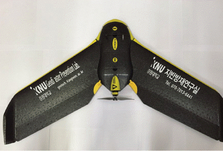
ļ│Ė ņŚ░ĻĄ¼ņŚÉņä£ ņé¼ņÜ®ĒĢ£ ļ¼┤ņØĖĒĢŁĻ│ĄĻĖ░ļŖö Fig. 1Ļ│╝ Ļ░ÖņØĆ Ļ│ĀņĀĢņØĄņ£╝ļĪ£ Ēü¼ĻĖ░ļŖö 950 ├Ś 630 ├Ś 70 mmņØ┤Ļ│Ā, ļ¼┤Ļ▓īļŖö ņĢĮ 690 gņØ┤ļ®░ ĒöäļĪ£ĒÄĀļ¤¼ 1Ļ░£ļĪ£ ĻĄ¼ņä▒ļÉśņ¢┤ ņ׳ļŗż. ņ┤¼ņśü Ļ┤æĒĢÖņä╝ņä£ļŖö Sony S110RGB(1,200ļ¦īĒÖöņåī)ļź╝ ņØ┤ņÜ®ĒĢśņśĆĻ│Ā, ņóīĒæ£ ņĘ©ļōØņØä ņ£äĒĢśņŚ¼ Sokkiaņé¼ņØś GRX2ļź╝ ņé¼ņÜ®ĒĢśņśĆĻ│Ā, ĻĖ░ņāüĻĖ░ņżĆņĀÉņØś ĒśäņןņĖĪļ¤ēņØä ņŗżņŗ£ĒĢśņśĆļŗż.
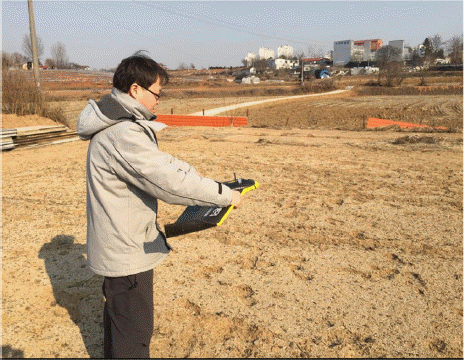
UAVļŖö ņ×ÉļÅÖ ĒĢŁļĪ£ ņäżņĀĢ S/WņØĖ eMotion2ļź╝ ņØ┤ņÜ®ĒĢśņŚ¼ ņ┤¼ņśüĻ▓ĮļĪ£ļź╝ ņäżņĀĢĒĢśĻ▓ī ļÉśļ®░, ņäżņĀĢļÉ£ ļ╣äĒ¢ēĻ▓ĮļĪ£ļź╝ ļö░ļØ╝ ļīĆņāüņ¦ĆņŚŁņØś ņ┤¼ņśüņØä ĒĢśĻ▓ī ļÉ£ļŗż. ņ┤¼ņśü ņ¦äĒ¢ēņŗ£ UAVņÖĆ ņ×æņŚģņ×ÉļŖö USB ņ¦Ćņāüļ¬©ļÄĆņØä ĒåĄĒĢ┤ ļģĖĒŖĖļČüĒÖöļ®┤ņ£╝ļĪ£ ņŗżņŗ£Ļ░ä ļ╣äĒ¢ē ĒśäĒÖ®ņØä ĒīīņĢģĒĢśļ®░, Ēśäņן ĻĖ░ņāüņāüĒā£ņŚÉ ļö░ļØ╝ ņ┤¼ņśü ņżæņ▓®ļÅäļź╝ ņäżņĀĢĒĢśĻ▓ī ļÉ£ļŗż. ņØ┤ļĢī, ņ┤¼ņśü ņżæņ▓®ļÅäļŖö ĻĖ░ņāüņāüĒā£ņŚÉ ļö░ļØ╝ 60~75%ļĪ£ ņäżņĀĢņØä ĻČīņןĒĢśĻ│Ā ņ׳ļŗż. ņĘ©ļōØņśüņāüņØś ņÖ£Ļ│Ī ļ░®ņ¦ĆļŖö ņ¦ĆņāüĻĖ░ņżĆņĀÉ ņĪ░ņé¼ļź╝ ņŗżņŗ£ĒĢśņŚ¼ ĻĖ░ņżĆņĀÉņØś ņóīĒæ£ļź╝ GPS ņĖĪļ¤ēņØä ĒåĄĒĢśņŚ¼ ĒÜŹļōØĒĢśĻ│Ā, ņĘ©ļōØĒĢ£ Ļ░üņĀÉņØś ņóīĒæ£ļź╝ ĻĖ░ņżĆņ£╝ļĪ£ ņ┤¼ņśü ņé¼ņ¦ä ņĀæĒĢ®ņŗ£ ņ×äņØśņØś ņĀÉļōżņØś ņóīĒæ£ļź╝ ņāØņä▒ĒĢśĻ▓ī ļÉśņ¢┤ 3Dļ¬©ļŹĖņØś ņóīĒæ£ļź╝ ļ│┤ņĀĢĒĢśĻ▓ī ļÉ£ļŗż. GPSņĖĪļ¤ēņä▒Ļ│╝ļŖö Ēøäņ▓śļ”¼ļ░®ļ▓ĢņØä ĒåĄĒĢśņŚ¼ 3Dļ¬©ļŹĖņØś ņśżņ░©ļ▓öņ£äļź╝ ņżäņØ┤ļŖö ļŹ░ņŚÉ ņé¼ņÜ®ļÉ£ļŗż. ņśüņāüĒĢ┤ņäØņØĆ Postflight Terra 3DņÖĆ Virtual Surveyorļź╝ ĒåĄĒĢ┤ 2D ĒÅēļ®┤ļÅä ļ░Å 3D ņ¦ĆĒśĢļÅäļź╝ ņ×æņä▒ĒĢśņśĆļŗż.
Postflight Terra 3DļŖö ņé¼ņ¦äņĖĪļ¤ē ņåīĒöäĒŖĖņø©ņ¢┤ļĪ£ņä£ Ļ░äļŗ©ĒĢ£ ņäżņĀĢņØä ĒåĄĒĢ┤ LOGļŹ░ņØ┤Ēä░(ļ╣äĒ¢ēļ¬©ņģśļŹ░ņØ┤Ēä░)ļź╝ ņ×ģĒ×ī ņé¼ņ¦äļōżņØä ņĀæĒĢ®ĒĢśņŚ¼ cmĻĖēņØś ņĀĢņé¼ņśüņāüĻ│╝ DSM(Digital Surface Model) ņĀ£ņ×æņØ┤ Ļ░ĆļŖźĒĢśļ®░, ņØ┤Ēøä Virtual Surveyorļź╝ ĒåĄĒĢ┤ņä£ ņĀĢņé¼ņśüņāüĻ│╝DSMņØä Ļ▓░ĒĢ®ĒĢśņŚ¼ 3Dņ¦ĆĒśĢļÅäļź╝ ņāØņä▒ĒĢ£ļŗż. GEOIDņé¼ņØś Virtual SurveyorļŖö Ļ░ĆņāüņĖĪļ¤ē ĒöäļĪ£ĻĘĖļשņ£╝ļĪ£ ņŚ¼ļ¤¼ ļĀłņØ┤ņ¢┤ļōżņØä Ļ▓╣ņ│Éņä£ ļ│╝ ņłś ņ׳ņ£╝ļ®░, ņĀĢņé¼ņśüņāüņØś TIF ņØ┤ļ»Ėņ¦ĆņÖĆ DEM ņłśņ╣śĒæ£Ļ│ĀļŹ░ņØ┤Ēä░ļź╝ Ļ▓░ĒĢ®ĒĢ£ ņāüĒā£ņŚÉņä£ 3ņ░©ņøÉņĀü ļ¬©ļŹĖļ¦ü ņ×æņŚģņØ┤ Ļ░ĆļŖźĒĢśļŗż. ļśÉĒĢ£, ļ▓ĪĒä░ļØ╝ņØ┤ņ¦Ģ ņ×æņŚģļÅä 3ņ░©ņøÉ ļĘ░ņ¢┤ĻĖ░ļŖźņØä ņØ┤ņÜ®ĒĢśņŚ¼ ļŗżĻ░üļÅäļĪ£ņśüņāüĒÖöļ®┤ņØä ņŗżņŗ£Ļ░ä ņāüĒĢśņóīņÜ░ļĪ£ ņØ┤ļÅÖņØ┤ Ļ░ĆļŖźĒĢśĻĖ░ ļĢīļ¼ĖņŚÉ ĒśäņןņŚÉ ņ׳ļŖö Ļ▓āĻ│╝ ļÅÖņØ╝ĒĢ£ ņāüĒÖ®ņØä ļ¦īļōżņ¢┤ ļé┤Ļ│Ā ņØ╝ļ░ś ļ¬©ļŗłĒä░ņŚÉņä£ļÅä 3ņ░©ņøÉ ņ×ģņ▓┤ņŗ£ ĒīÉļÅģņØ┤ Ļ░ĆļŖźĒĢśļ»ĆļĪ£ UAVļź╝ ĒÖ£ņÜ®ĒĢ£ ņ¦ĆļÅä ņĀ£ņ×æņŚÉ ļ¦ÄņØ┤ ņé¼ņÜ®ļÉśĻ│Ā ņ׳ņ£╝ļ®░, ĒŖ╣Ē׳ ņ▓śļ”¼Ļ│╝ņĀĢņØ┤ ņŗĀņåŹĒĢśĻ│Ā ņ╣©ņłśņŗ¼ ļ░Å ņ╣©ņłśļ▓öņ£äļź╝ ņāüļŗ╣Ē׳ ņĀĢĒÖĢĒĢśĻ▓ī Ēæ£ĒśäĒĢĀ ņłś ņ׳ļŖö ņןņĀÉņØ┤ ņ׳ļŖö Ļ▓āņ£╝ļĪ£ ņĢīļĀżņĀĖ ņ׳ļŗż. ļö░ļØ╝ņä£ ļ│Ė ņŚ░ĻĄ¼ņØś ņ╣©ņłśĒØöņĀüļÅä ņ×æņä▒ ļ¬®ņĀüņŚÉ ļČĆĒĢ®ĒĢĀ Ļ▓āņ£╝ļĪ£ ĒīÉļŗ©ļÉśņ¢┤ Postflight Terra 3D ĒöäļĪ£ĻĘĖļשņØä ņäĀĒāØĒĢśņśĆļŗż.
2.2 ļŹ░ņØ┤Ēä░ ņĘ©ļōØ ļ░Å ņ▓śļ”¼
ļ│Ė ņŚ░ĻĄ¼ņŚÉņä£ ņ╣©ņłśĒØöņĀüļÅä ņ×æņä▒ņØä ņ£äĒĢ£ ņ×ÉļŻīņ▓śļ”¼ ļ░Å Ēö╝ĒĢ┤ļ®┤ņĀüņé░ņĀĢ Ļ│╝ņĀĢņØĆ Fig. 2ņÖĆ Ļ░Öļŗż. ļ©╝ņĀĆ, ņ╣©ņłśĒØöņĀüļÅä ļ╣äĻĄÉļź╝ ņ£äĒĢ£ ĻĖ░ņ×æņä▒ļÉ£ ņ╣©ņłśĒØöņĀüļÅäļź╝ ĒåĀļīĆļĪ£ UAV ņ┤¼ņśüņØ┤ ņÜ®ņØ┤ĒĢ£ ņ¦ĆņŚŁņØä ņäĀņĀĢĒĢ£ļŗż. ļīĆņāüņ¦ĆņŚŁ ņäĀņĀĢ Ēøä, ņĘ©ļōØ ņśüņāüņØś ņśüņāüņĀæĒĢ®(ļ¬©ņ×ÉņØ┤Ēü¼)ņŚÉ ļö░ļźĖ ņśüņāüņÖ£Ļ│Ī ņśżņ░©ļź╝ ņĄ£ņåīĒÖöĒĢśĻĖ░ ņ£äĒĢ£ GCP(Ground Control Point) ņĖĪļ¤ēņØä ņŗżņŗ£ĒĢśĻ│Ā, UAVļź╝ ņØ┤ņÜ®ĒĢ£ ĒĢŁĻ│ĄņśüņāüņØä ņĘ©ļōØĒĢ£ļŗż. ņĘ©ļōØĒĢ£ ĒĢŁĻ│ĄņśüņāüņØś ņ×ÉļŻī ņ▓śļ”¼ļź╝ ĒåĄĒĢ£ ņĀĢņé¼ņśüņāü ļ░Å DSM(Digital Surface Model)ņØä ņāØņä▒ĒĢśĻ│Ā, GCPņØś ņĖĪļ¤ēĻ░ÆĻ│╝ ņĀĢņé¼ņśüņāüņØä ĒÖ£ņÜ®ĒĢ£ ņĀĢĒÖĢļÅä ĒÅēĻ░ĆĻ░Ć ņØ┤ļŻ©ņ¢┤ņ¦äļŗż. ņØ┤Ēøä 3D ņ¦ĆĒśĢļÅäļź╝ ņČöņČ£ĒĢśņŚ¼ ĒĢ┤ļŗ╣ ņ¦ĆņŚŁņØś ņ╣©ņłśĒö╝ĒĢ┤ ļ▓öņ£äļź╝ ņé░ņĀĢĒĢ£ļŗż.
3. ņ╣©ņłśĒØöņĀüļÅä ņ×æņä▒
3.1 ļīĆņāüņ¦ĆņŚŁ ņäĀņĀĢ
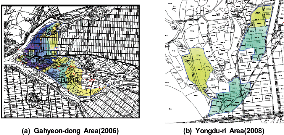
ļ│Ė ņŚ░ĻĄ¼ņŚÉņä£ļŖö 2006ļģäĻ│╝ 2008ļģäņØś ņ╣©ņłśĒö╝ĒĢ┤ļĪ£ ņØĖĒĢ£ ņ╣©ņłśĒØöņĀüļÅäļź╝ ļ│┤ņ£ĀĒĢśĻ│Ā ņ׳Ļ│Ā, UAV ņ┤¼ņśüņØ┤ ņÜ®ņØ┤ĒĢśļ®░, ņ£ĀņŚŁ ĒśäĒÖ® ļśÉĒĢ£ ļÅäņŗ¼ņ¦Ć ļ░Å ļåŹĻ▓Įņ¦ĆņØś ņ╣©ņłśĒö╝ĒĢ┤Ļ░Ć ļ░£ņāØĒĢ£ ņ¦ĆņŚŁņØĖ Ļ▓ĮĻĖ░ļÅäņĢłņä▒ņŗ£ņØś Ļ░ĆĒśäļÅÖ ņØ╝ņøÉĻ│╝ Ļ│ĄļÅäņØŹ ņÜ®ļæÉļ”¼ ņØ╝ņøÉņØä ņŚ░ĻĄ¼ ļīĆņāüņ¦ĆļĪ£ ņäĀņĀĢĒĢśņśĆļŗż.
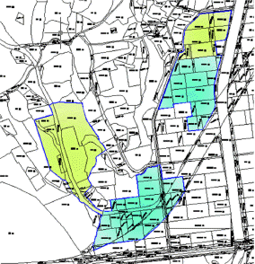
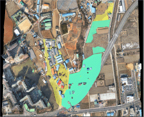
Ļ▓ĮĻĖ░ļÅä ņĢłņä▒ņŗ£ Ļ░ĆĒśäļÅÖ ņØ╝ņøÉņØĆ 2006ļģä 7ņøö 25ņØ╝ ņ¦æņżæĒśĖņÜ░ ļ░Å ņĀ£3ĒśĖ Ēā£ĒÆŹ ŌĆśņŚÉņ£äļŗłņĢäŌĆÖņØś ņśüĒ¢źņ£╝ļĪ£ ĒĢśņ▓£ņØś ņĀ£ļ░®ņØ┤ ļČĢĻ┤┤ļÉśņ¢┤ ņŻ╝ĒāØĒīīņåÉ ļ░Å ņ╣©ņłś, ļåŹĻ▓Įņ¦Ć ļ¦żļ¬░ ļ░Å ņ╣©ņłś ļō▒ņØś Ēö╝ĒĢ┤Ļ░Ć ļ░£ņāØĒĢśņśĆļŗż. 2006ļģä 7ņøö 28ņØ╝ 12:00ļČĆĒä░ 2006ļģä 7ņøö 29ņØ╝ 02:00Ļ╣īņ¦Ć ņ╣©ņłśĻ░Ć ļ░£ņāØĒĢśņśĆĻ│Ā, ņ╣©ņłśņŗ¼ņØĆ ņĢĮ 0.5 m~ 3.0m, Ēö╝ĒĢ┤ņŗ£ņäżņØĆ Ļ░Ćņśź ļ░Å ļåŹĻ▓Įņ¦ĆņØ┤ļ®░ Ēö╝ĒĢ┤ļ®┤ņĀüņØĆ 617,294 m2ņØ┤ļŗż. 2006ļģä Ļ▓ĮĻĖ░ļÅä ņĢłņä▒ņŗ£ Ļ░ĆĒśäļÅÖ ņØ╝ņøÉņØś ņ╣©ņłśĒØöņĀüļÅäļŖö Fig. 3(a)ņÖĆ Ļ░Öļŗż. ļśÉĒĢ£ 2008ļģä 7ņøö 23ņØ╝~26ņØ╝ ņ¦æņżæĒśĖņÜ░ļĪ£ Ļ▓ĮĻĖ░ļÅä ņĢłņä▒ņŗ£ Ļ│ĄļÅäņØŹ ņÜ®ļæÉļ”¼ ņØ╝ņøÉņØ┤ 2008ļģä 7ņøö 24ņØ╝ 1ņØ╝Ļ░ä ņŻ╝ĒāØņ╣©ņłś 21Ļ░ĆĻĄ¼, ļåŹĻ▓Įņ¦Ć 4.85 ha, Ļ░ĆņČĢņ×ģņŗØ 1ļÅÖ ļō▒ ņŗ£ņäżĒö╝ĒĢ┤Ļ░Ć ļ░£ņāØĒĢśņśĆĻ│Ā, Ļ│ĄļÅäņé╝Ļ▒░ļ”¼ļČĆĻĘ╝ ņāüĻ░Ć 3ņ▒ä, ļåŹĻ▓Įņ¦Ć ņØ╝ļČĆ ļ░Å ĻĖ░ņŚģļŗ©ņ¦Ć ņØ╝ļČĆĻ░Ć ņ╣©ņłśļÉśņŚłļŗż. Ēö╝ĒĢ┤ļ®┤ņĀüņØĆ ņĢĮ 80,433 m2ņØ┤ļ®░, Ēö╝ĒĢ┤ņĢĪņØĆ ņĢĮ 710,371ņ▓£ņøÉņ£╝ļĪ£ ņ¦æĻ│äļÉśņŚłļŗż. Ēö╝ĒĢ┤ņøÉņØĖņØĆ ņŖ╣ļæÉņ▓£ņØś ņłśņ£äĻ░Ć ņāüņŖ╣ļÉ©ņŚÉ ļö░ļØ╝ ņāüļīĆņĀüņ£╝ļĪ£ ņ¦Ćļ░śĻ│ĀĻ░Ć ļé«ņØĆ ĻĖ░ņŚģļŗ©ņ¦Ć ņ×ģĻĄ¼ ņ¦ĆņŚŁņØś ļé┤ņłśņ╣©ņłśĻ░Ć ļ░£ņāØĒĢśņśĆļŗż. 2008ļģä Ļ▓ĮĻĖ░ļÅä ņĢłņä▒ņŗ£ Ļ│ĄļÅäņØŹ ņÜ®ļæÉļ”¼ ņØ╝ņøÉņØś ņ╣©ņłśĒØöņĀüļÅäļŖö Fig. 3(b)ņÖĆ Ļ░Öļŗż. ļśÉĒĢ£, ņ╣©ņłśņŗ¼ņØś ļ▓öņ£ä ļ░Å ņāēņāüņØĆ Table 1Ļ│╝ Ļ░Öļŗż.


3.2 ļīĆņāüņ¦ĆņŚŁņØś ņśüņāüņ×ÉļŻī ņČöņČ£
ļ│Ė ņŚ░ĻĄ¼ņØś ļīĆņāüņ¦ĆņŚŁņØĖ ņ╣©ņłś Ēö╝ĒĢ┤Ļ░Ć ļ░£ņāØĒĢ£ ņ£ĀņŚŁņŚÉ ļīĆĒĢ┤ ņ┤¼ņśü ņŗ£ ĻĖ░ņāüņĪ░Ļ▒┤ņØ┤ ņ¢æĒśĖĒĢśņŚ¼ eMotion2ņØś ĻĖ░ļ│Ė ņäżņĀĢļÉ£ ņóģļ░®Ē¢ź 60%, ĒÜĪļ░®Ē¢ź 75%ņØś ņżæņ▓®ļÅäļĪ£ ņäżņĀĢĒĢśņŚ¼ ņĢłņä▒ņŗ£ Ļ░ĆĒśäļÅÖ ņØ╝ņøÉĻ│╝ Ļ│ĄļÅäņØŹ ņÜ®ļæÉļ”¼ ņØ╝ņøÉņŚÉ ļīĆĒĢśņŚ¼ Ļ░üĻ░ü 3ĒÜī, 1ĒÜīļĪ£ ļéśļłäņ¢┤ 880ņן(312ņן + 292ņן + 276ņן), 227ņןņØä ņ┤¼ņśüĒĢśņśĆļŗż. UAV ņ┤¼ņśüņŗ£Ļ░äņØĆ ĻĖ░ņāüĒśäĒÖ®, ņżæņ▓®ļÅä ļ╣äņ£© ļ░Å ļ░░Ēä░ļ”¼ ņāüĒā£ņŚÉ ļö░ļØ╝ ņĄ£ļīĆ45ļČä ņØ┤ļé┤ļĪ£ ņäżņĀĢņØ┤ ĒĢäņÜöĒĢśĻĖ░ ļĢīļ¼ĖņŚÉ Ļ░ĆĒśäļÅÖņØś Ļ▓ĮņÜ░ ņżæņ▓®ļÅä ņäżņĀĢņŚÉ ļö░ļØ╝ ņ┤Ø 3ĒÜīļĪ£ ļéśļłäņ¢┤ ņ┤¼ņśüņØä ĒĢśņśĆļŗż(Fig. 4). UAVņśüņāü ņ┤¼ņśüļ®┤ņĀüņØĆ Ļ░ĆĒśäļÅÖ ņØ╝ņøÉņØ┤ ņĢĮ 3.25 km2, ņÜ®ļæÉļ”¼ ņØ╝ņøÉņØ┤ ņĢĮ 2.17 km2ņØ┤ļ®░, Ļ│ĄĻ░äĒĢ┤ņāüļÅäļŖö 4 cm/pixelļĪ£ ņ┤łĻ│ĀĒĢ┤ņāüļÅä ņśüņāüņØ┤ļŗż.

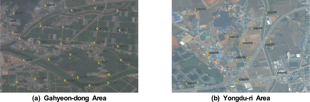
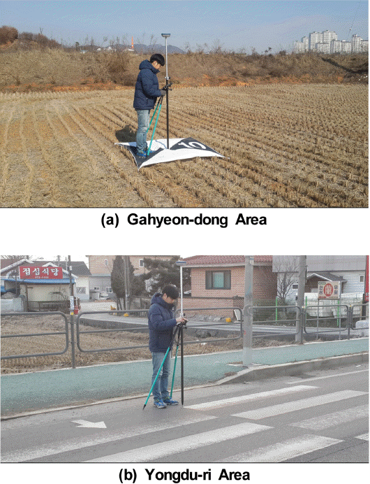
ļ¼┤ņØĖĒĢŁĻ│Ą ņé¼ņ¦äņĖĪļ¤ē ņŗ£ņŖżĒģ£ņØś ņĀĢĒÖĢļÅä ļČäņäØņØĆ Table 2ņÖĆ Ļ░ÖņØ┤ ļīĆņāüņ¦ĆņŚŁ ļé┤ņŚÉ ņłśņ¦ü ļ░Å ņłśĒÅēļ░®Ē¢źņ£╝ļĪ£ ņĢĮ 400m Ļ░äĻ▓®ņ£╝ļĪ£ ņäżņĀĢĒĢśņŚ¼ Ļ░ĆĒśäļÅÖ ņØ╝ņøÉņØĆ 26Ļ░£, ņÜ®ļæÉļ”¼ ņØ╝ņøÉņØĆ 11Ļ░£ņØś ĻĖ░ņżĆņĀÉņØä ņäĀņĀĢĒĢśĻ│Ā, GPSņĖĪļ¤ēņØä Fig. 5ņÖĆ Table 2ņÖĆ Ļ░ÖņØ┤ ņŗżņŗ£ĒĢśņŚ¼ ņśüņāüņĀæĒĢ®(ļ¬©ņ×ÉņØ┤Ēü¼)ņŚÉ ļö░ļźĖ ņśüņāüņÖ£Ļ│Ī ņśżņ░©ļź╝ ņĄ£ņåīĒÖö ĒĢśņśĆļŗż. Fig. 6ļŖö ļīĆņāüņ¦ĆņŚŁ ĒĢŁĻ│Ąņśüņāü ņ┤¼ņśüņØä ņ£äĒĢ£ UAV ņØ┤ļźÖ ņé¼ņ¦äņØ┤Ļ│Ā, ņØ┤ļź╝ ĒåĄĒĢ┤ ņĘ©ļōØĒĢ£ ĒĢŁĻ│ĄņśüņāüņØś ņ×ÉļŻī ņ▓śļ”¼ļź╝ ĒåĄĒĢ£ ņĀĢņé¼ņśüņāüņØĆ Fig. 7ņØ┤Ļ│Ā, ņĀĢĒÖĢļÅä ĒÅēĻ░Ćļź╝ ņ£äĒĢ£ Ļ▓Ćņé¼ņĀÉ ņóīĒæ£ ņĘ©ļōØņØĆ Fig. 8Ļ│╝ Ļ░Öļŗż.
Table┬Ā2
Survey of Check-Points


3.3 ņĀĢĒÖĢļÅä ĒÅēĻ░Ć
ļ│Ė ņŚ░ĻĄ¼ņŚÉņä£ ņé¼ņÜ®ĒĢ£ UAVļŖö ņé¼ņ¦äņ┤¼ņśü Ēøä ņ¦ĆņāüĻĖ░ņżĆņĀÉņØä ņé¼ņÜ®ĒĢśņ¦Ć ņĢŖĻ│Ā 3D ļ¬©ļŹĖņØś ņāØņä▒ņØ┤ Ļ░ĆļŖźĒĢśļŗż. ĒĢśņ¦Ćļ¦ī ņØ┤ļ¤░ Ļ▓ĮņÜ░ Ļ░üņĀÉņØś ņóīĒæ£ņśżņ░©Ļ░Ć ņłśņŗŁcm Ēś╣ņØĆ ņłśmņØś ņśżņ░©ļź╝ ļ│┤ņØ┤Ļ▓ī ļÉśņ¢┤ Ļ░ĆņāüņĖĪļ¤ē ĒöäļĪ£ĻĘĖļשņØä ņØ┤ņÜ®ĒĢśņŚ¼ ĒśäĒÖ®ņĖĪļ¤ēņØ┤ļéś ņ╣©ņłśļ▓öņ£äļź╝ ļéśĒāĆļé┤ļŖöļŹ░ ņŗĀļó░ņä▒ņØ┤ ļ¢©ņ¢┤ņ¦ĆĻ▓ī ļÉ£ļŗż. ļö░ļØ╝ņä£ ļ│Ė ņŚ░ĻĄ¼ņŚÉņä£ļŖö ņĀĢņé¼ņśüņāü ņāØņä▒ņØä ņ£äĒĢ┤ Ļ░üĻ░ü 26ņĀÉ(Ļ░ĆĒśäļÅÖ ņØ╝ņøÉ), 11ņĀÉ(ņÜ®ļæÉļ”¼ ņØ╝ņøÉ)ņØś ņ¦ĆņāüĻĖ░ņżĆņĀÉ ņĖĪļ¤ēņØä ņŗżņŗ£ĒĢśņśĆĻ│Ā, Fig. 9ņÖĆ Ļ░ÖņØ┤ ĒĢŁĻ│Ąņ┤¼ņśüņé¼ņ¦äņŚÉņä£ ņ£ĪņĢłņ£╝ļĪ£ ņŗØļ│ä Ļ░ĆļŖźĒĢ£ 1.5 m ├Ś 1.5 m Ēü¼ĻĖ░ņØś ļīĆĻ│ĄĒæ£ņ¦ĆĒīÉĻ│╝ ļÅäļĪ£Ēæ£ņŗØņØä ņé¼ņÜ®ĒĢśņŚ¼ ņóīĒæ£ņĀÉņØä ĒÜŹļōØ ĒĢśņśĆļŗż. ņØ┤Ēøä ņØ╝ļĀ©ņØś Ļ│╝ņĀĢņØä Ļ▒░ņ│É ņĄ£ņóģņĀüņ£╝ļĪ£ ĒÜŹļōØļÉ£ 3D ļ¬©ļŹĖĻ│╝ ņ¦ĆņāüĻĖ░ņżĆņĀÉņĖĪļ¤ēņ£╝ļĪ£ ņ¢╗ņØĆ Ļ░üņĀÉņØś ņóīĒæ£ļź╝ Table 3Ļ│╝ Ļ░ÖņØ┤ ļ╣äĻĄÉĒĢśņŚ¼ ĒÜŹļōØĒĢ£ ņ×ÉļŻīņØś ņŗĀļó░ņä▒ņØä ĒÖĢļ│┤ ĒĢśņśĆļŗż.
Table┬Ā3
Accuracy of Check-Points in Orthophoto
Table 3Ļ│╝ Ļ░ÖņØ┤ Ļ░ĆĒśäļÅÖ ņØ╝ļīĆņØś ņ┤¼ņśüņśüņāü ņĀĢĒÖĢļÅä ĒÅēĻ░Ć Ļ▓░Ļ│╝ X, Y, Z Ļ░ü ņä▒ļČäļ│ä ĒÄĖņ░©ļŖö ĒÅēĻĘĀ 0.08 m, 0.07 m, 0.04 mļĪ£ ļéśĒāĆļé¼ļŗż. ņłśĒÅē ļ░®Ē¢ź ņśżņ░©ļŖö ĒÅēĻĘĀ 7.5 cm ņØ┤ļé┤ņØś Ļ░ÆņØä ļéśĒāĆļé┤ņŚłņ£╝ļ®░, ņłśņ¦üļ░®Ē¢źņØś Ļ▓ĮņÜ░ ĒÅēĻĘĀ 4 cm ņĀĢļÅäņØś ĒÄĖņ░©ļź╝ ļ│┤ņśĆļŗż. ņÜ®ļæÉļ”¼ ņØ╝ņøÉņØś Ļ▓ĮņÜ░ X, Y, Z Ļ░ü ņä▒ļČäļ│ä ĒÄĖņ░©ļŖö 0.07 m, 0.02 m, 0.02 mļĪ£ ļéśĒāĆļé¼ļŗż. ņłśĒÅēļ░®Ē¢ź ņśżņ░©ļŖö ĒÅēĻĘĀ 4.5cmņØ┤ĒĢśņØś Ļ░ÆņØä ļéśĒāĆļé┤ņŚłņ£╝ļ®░, ņłśņ¦üļ░®Ē¢źņØś Ļ▓ĮņÜ░ 2 cm ņĀĢļÅäņØś ĒÄĖņ░©ļź╝ ļéśĒāĆļé┤ņŚłļŗż. ņāØņä▒ļÉ£ ļæÉ ņĀĢņé¼ņśüņāü ļ¬©ļæÉ ņĢĮ 4.0 cmĻĖē ņśüņāüņ£╝ļĪ£ ļÅäļĪ£ ļ░Å ņŗ£ņäżļ¼╝ņØś ĒīÉļÅģņØ┤ Ļ░ĆļŖźĒĢśĻĖ░ ļĢīļ¼ĖņŚÉ ņĀĢņé¼ņśüņāüņØä ĒÖ£ņÜ®ĒĢ£ ĒśäĒÖ®ņĖĪļ¤ē ļÅäļ®┤ ņĀ£ņ×æņŚÉ ĒÖ£ņÜ®ĒĢĀ ņłś ņ׳ļŗż. ņØ┤ņÖĆ Ļ░ÖņØĆ Ļ▓░Ļ│╝ļŖö ļ¼┤ņØĖĒĢŁĻ│ĄĻĖ░ļź╝ ņØ┤ņÜ®ĒĢ£ ĒśäĒÖ®ņĖĪļ¤ēņØ┤ Ļ░ĆļŖźĒĢ£ Ļ▓āņ£╝ļĪ£ ĒīÉļŗ©ļÉ£ļŗż.
4. ļ╣äĻĄÉ ļ░Å Ļ│Āņ░░
4.1 ņ╣©ņłśĒØöņĀüļÅä ļ╣äĻĄÉ
Fig. 3ņØś 2006ļģä Ļ▓ĮĻĖ░ļÅä ņĢłņä▒ņŗ£ Ļ░ĆĒśäļÅÖ ņØ╝ņøÉĻ│╝ 2008ļģä Ļ▓ĮĻĖ░ļÅä ņĢłņä▒ņŗ£ Ļ│ĄļÅäņØŹ ņÜ®ļæÉļ”¼ ņØ╝ņøÉņŚÉ ļ░£ņāØĒĢ£ ņ╣©ņłśĒö╝ĒĢ┤ ļ▓öņ£äļź╝ ļ╣äĻĄÉĒĢśņśĆļŗż. ļ│Ė ņŚ░ĻĄ¼ņŚÉņä£ ļČäņäØĒĢ£ ņ╣©ņłśļ▓öņ£äļŖö Table 4ņÖĆ Ļ░ÖĻ│Ā 2006ļģä Ļ░ĆĒśäļÅÖ ņØ╝ņøÉņŚÉ ļīĆĒĢ£ ņ╣©ņłśĒö╝ĒĢ┤ ļ®┤ņĀüņØĆ 617,294 m2, 2008ļģä ņÜ®ļæÉļ”¼ ņØ╝ņøÉņØĆ ņĢĮ 80,433 m2ņØ┤ļŗż. ļ¼┤ņØĖĒĢŁĻ│ĄĻĖ░ļź╝ ĒÖ£ņÜ®ĒĢ£ ņ╣©ņłśĒö╝ĒĢ┤ ļ®┤ņĀüņØĆ Ļ░üĻ░ü 590,982 m2, 88,409 m2ļĪ£ ņĢĮ 4.27%, 9.91% ņ░©ņØ┤Ļ░Ć ļéśļŖö Ļ▓āņ£╝ļĪ£ ļéśĒāĆļé¼ļŗż. ņØ┤ļŖö ņ╣©ņłśĒö╝ĒĢ┤ ļŗ╣ņŗ£ņØś ņ¦ĆĒśĢĻ│╝ ņ╣©ņłśĒö╝ĒĢ┤ ņØ┤Ēøä Ļ▒┤ņäżĻ│Ąņé¼ļĪ£ ņØĖĒĢ£ Ēśäņ×¼ņØś ņ¦ĆĒśĢ ņ░©ņØ┤ļĪ£ ņØĖĒĢ£ Ļ▓āņ£╝ļĪ£ ĒīÉļŗ©ļÉ£ļŗż.

4.2 ĒĢśņ▓£ ņłśņ£äņŚÉ ļö░ļźĖ ņ╣©ņłśļ▓öņ£ä ņé░ņĀĢ
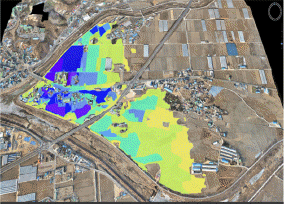
ņĢłņä▒ņŗ£ Ļ░ĆĒśäļÅÖ ņ¦ĆņŚŁņØĆ ņĢłņä▒ņ▓£Ļ│╝ ņĢłņä▒ņ▓£ ņóīņĢłņ£╝ļĪ£ ņ£Āņ×ģļÉśļŖö ņĪ░ļĀ╣ņ▓£ņØä ņĀæĒĢśĻ│Ā ņ׳ļŗż. ņØ┤ ņ¦ĆņŚŁņØś ĒĢśņ▓£ ņłśņ£ä ļ│ĆĒÖöņŚÉ ļö░ļźĖ ļé┤ņłśņ╣©ņłśņØś Ļ▓ĮņÜ░ļź╝ Ļ░ĆņĀĢĒĢśņŚ¼ ņ╣©ņłśļ▓öņ£äļź╝ ņśłņĖĪĒĢśņśĆļŗż. ņØ┤ļ¤¼ĒĢ£ ņśłņĖĪ ļ▓öņ£äļŖö ņĢłņä▒ņŗ£ Ļ░ĆĒśäļÅÖ ņ¦ĆņŚŁņØś Ļ▓ĮņÜ░ ļé┤ņłśņ╣©ņłśĻ░Ć ņĢłņä▒ņ▓£ ļ░Å ņĪ░ļĀ╣ņ▓£ ļō▒ ĒĢśņ▓£ņłśņ£ä ļ│ĆĒÖöņŚÉ ļ»╝Ļ░ÉĒĢśĻĖ░ ļĢīļ¼ĖņŚÉ ņłśņ£ä ņāüņŖ╣ņŚÉ ļö░ļźĖ ņ╣©ņłśĒö╝ĒĢ┤ ļō▒ ĒĢśņ▓£ņ×¼ļé£ņŚÉ ļīĆĒĢ£ ņŗĀņåŹĒĢ£ Ēö╝ĒĢ┤ ņāüĒÖ®ņØä ĒīīņĢģĒĢśļŖö ņÜ®ļÅäļĪ£ ĒÖ£ņÜ®ņØ┤ Ļ░ĆļŖźĒĢĀ Ļ▓āņ£╝ļĪ£ ĒīÉļŗ©ļÉ£ļŗż. ĻĘĖļ¤¼ļ»ĆļĪ£ ļ│Ė ņŚ░ĻĄ¼ņŚÉņä£ļŖö Fig. 10Ļ│╝ Ļ░ÖņØ┤ ņĢłņä▒ņ▓£Ļ│╝ ņĪ░ļĀ╣ņ▓£ņØś ĒĢ®ļźśņĀÉ ļČĆĻĘ╝ņØś ņłśņ£äļź╝ Ļ░ĆņĀĢĒĢśņŚ¼ Ļ░ĆĒśäļÅÖ ņØ╝ņøÉņØś ļé┤ņłśņ╣©ņłś ļ▓öņ£äņØś ļ│ĆĒÖöļź╝ ļ¬©ņØśĒĢśņśĆļŗż.
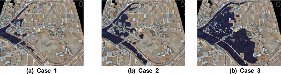
Fig. 10ņŚÉņä£ Case 1ņØĆ ņĪ░ļĀ╣ņ▓£ņØś ņłśņ£äĻ░Ć 28.3(EL.m), Case 2ļŖö 29.3(EL.m), Case 3ļŖö 31.0(EL.m) Ļ▓ĮņÜ░ ņĀ£ļ░® ĒīīņĀ£ņŗ£ņØś ņ╣©ņłśļ®┤ņĀüņØĆ Case 1ņØĆ ņĢĮ 32,317 m2, Case 2ļŖö ņĢĮ 145,379 m2,ĻĘĖļ”¼Ļ│Ā Case 3ļŖö ņĢĮ 590,982 m2ļĪ£ ļČäņäØļÉśņŚłļŗż. ņØ┤ņÖĆ Ļ░ÖņØĆ ļČäņäØ Ļ▓░Ļ│╝ļź╝ ĒĢśņ▓£ ņÖĖņłśņ£ä ļ│ĆĒÖöņŚÉ ļö░ļØ╝ ļé┤ņłśņ╣©ņłśĻ░Ć ļ░£ņāØĒĢśļŖö ņ¦ĆņŚŁņØś ņ╣©ņłśļ▓öņ£äļź╝ ņé░ņĀĢĒĢśĻ│Ā ļČäņäØĒĢśļŖö ļŹ░ņŚÉ UAVļź╝ ĒÖ£ņÜ®ĒĢśņŚ¼ ņ╣©ņłśļ▓öņ£äņØś ļČäņäØņØ┤ Ļ░ĆļŖźĒĢĀ Ļ▓āņ£╝ļĪ£ ĒīÉļŗ©ļÉ£ļŗż. Ļ░ü ņ¦Ćņ×Éņ▓┤ņØś ļé┤ņłśņ╣©ņłś ļ░®ņ×¼ņŚÉ ļīĆĒĢ£ ĻĖ░ņ┤łņĀüņØĖ ņ×ÉļŻīļĪ£ ĒÖ£ņÜ®ņØ┤ Ļ░ĆļŖźĒĢĀ Ļ▓āņØ┤ļ®░, ņĄ£ĻĘ╝ ĻĖ░ņāüņØ┤ļ│ĆņŚÉ ļīĆĒĢ£ ņłśļ”¼ņłśļ¼ĖĒĢÖņĀüņØĖ ļČäņäØ Ļ▓░Ļ│╝ļź╝ ņĀüņÜ®ĒĢśņŚ¼ ņ╣©ņłśņśłņāüļ▓öņ£äļź╝ ņé░ņĀĢĒĢ£ļŗżļ®┤ ļŹöņÜ▒ ĒÜ©ņ£©ņĀüņØĖ ļ░®ņ×¼ļīĆņ▒ģ ņ×ÉļŻī ĒÖ£ņÜ®ņØ┤ Ļ░ĆļŖźĒĢĀ Ļ▓āņ£╝ļĪ£ ĒīÉļŗ©ļÉ£ļŗż.
5. Ļ▓░ļĪĀ
ļ│Ė ņŚ░ĻĄ¼ļŖö ņĄ£ĻĘ╝ ĒÖ£ņÜ®ļÅäĻ░Ć ļåÆņØĆ ļ¼┤ņØĖĒĢŁĻ│ĄĻĖ░ņØś ĒĢŁĻ│Ąņ┤¼ņśüĻĖ░ņłĀņØä ņØ┤ņÜ®ĒĢśņŚ¼ ņ╣©ņłśĒØöņĀüļÅäļź╝ ņĀĢĒÖĢĒĢśĻ│Ā ņŗĀņåŹĒĢśĻ▓ī ņĀ£ņ×æĒĢśĻĖ░ ņ£äĒĢ£ ļ░®ļ▓ĢņŚÉ ļīĆĒĢ£ ņŚ░ĻĄ¼ņØ┤ļ®░, ņŗĀņåŹĒĢ£ ļŹ░ņØ┤Ēä░ ņĘ©ļōØ ļ░Å ņÜ┤ņÜ®ļ╣äņÜ®ņØ┤ ņĀĆļĀ┤ĒĢ£ ļ¼┤ņØĖļ╣äĒ¢ēņŗ£ņŖżĒģ£ņØä ņØ┤ņÜ®ĒĢśņŚ¼ 3ņ░©ņøÉ Ļ│ĀĒĢ┤ņāüļÅä ņĀĢņé¼ņśüņāüņØä ņĘ©ļōØĒĢśĻ│Ā Ļ░ĆņāüņĖĪļ¤ē ĒöäļĪ£ĻĘĖļש(VST)ņØä ņØ┤ņÜ®ĒĢśņŚ¼ 2006ļģäĻ│╝ 2008ļģäņŚÉ ļ░£ņāØĒĢ£ Ļ▓ĮĻĖ░ļÅä ņĢłņä▒ņŗ£ņØś ņ╣©ņłśĒØöņĀüļÅäņÖĆ ļ╣äĻĄÉļź╝ ĒåĄĒĢ┤ ļŗżņØīĻ│╝ Ļ░ÖņØĆ Ļ▓░Ļ│╝ļź╝ ņ¢╗ņŚłļŗż.
ņ▓½ņ¦Ė, ļ¼┤ņØĖĒĢŁĻ│ĄĻĖ░ļź╝ ĒåĄĒĢ┤ ņāØņä▒ļÉ£ ņä▒Ļ│╝ņØś ņĀĢĒÖĢļÅä ĒÅēĻ░Ć Ļ▓░Ļ│╝, ņłśĒÅē ļ░®Ē¢ź ņśżņ░©ļŖö Ļ░ĆĒśäļÅÖ ļ░Å ņÜ®ļæÉļ”¼ ņØ╝ņøÉ Ļ░üĻ░ü ĒÅēĻĘĀ 7.5 cm, 4.5 cmņØ┤Ļ│Ā, ņłśņ¦üļ░®Ē¢źņØś Ļ▓ĮņÜ░ Ļ░üĻ░ü 4 cm, 2 cm ņĀĢļÅäņØś ĒÄĖņ░©ļź╝ ļéśĒāĆļāäņ£╝ļĪ£ņŹ© ņāØņä▒ļÉ£ ļæÉ ņĀĢņé¼ņśüņāü ļ¬©ļæÉ ņĢĮ 4.0 cmĻĖē ņśüņāüņ£╝ļĪ£ ļÅäļĪ£ ļ░Å ņŗ£ņäżļ¼╝ņØś ĒīÉļÅģņØ┤ Ļ░ĆļŖźĒĢśĻĖ░ ļĢīļ¼ĖņŚÉ ņĀĢņé¼ņśüņāüņØä ĒÖ£ņÜ®ĒĢ£ ĒśäĒÖ®ņĖĪļ¤ē ļÅäļ®┤ ņĀ£ņ×æņŚÉ ĒÖ£ņÜ®ĒĢĀ ņłś ņ׳ņ£╝ļ®░ ĻĖ░ņĪ┤ņØś ņ╣©ņłśĒØöņĀüļÅä ņ×æņä▒ņŚÉ ĒĢäņÜöĒĢ£ ņČĢņ▓ÖņŚÉ ņāüĻ┤ĆņŚåņØ┤ ņé¼ņÜ®ņ×ÉĻ░Ć ņ×Éņ£ĀļĪŁĻ▓ī ĒÖĢļīĆ, ņČĢņåīĻ░Ć Ļ░ĆļŖźĒĢśļŗż. ļö░ļØ╝ņä£ ļ¼┤ņØĖĒĢŁĻ│ĄĻĖ░ļź╝ ņØ┤ņÜ®ĒĢ£ ĒśäĒÖ®ņĖĪļ¤ēņØĆ ĒśäņŚģņŚÉ ņĀüņÜ® Ļ░ĆļŖźĒĢ£ Ļ▓āņ£╝ļĪ£ ĒīÉļŗ©ļÉ£ļŗż.
ļæśņ¦Ė, 2006ļģä Ļ▓ĮĻĖ░ļÅä ņĢłņä▒ņŗ£ Ļ░ĆĒśäļÅÖ ņØ╝ņøÉņŚÉ ļīĆĒĢ£ ņĀ£ļ░®ļČĢĻ┤┤ņŚÉ ļö░ļźĖ ņ╣©ņłśļ▓öņ£äļŖö ņ¦üņĀæ ņĖĪļ¤ē ņĪ░ņé¼ļ░®ļ▓ĢĻ│╝ ļ╣äĻĄÉĒĢśņŚ¼ ņĢĮ 4.27%, 2008ļģä Ļ▓ĮĻĖ░ļÅä ņĢłņä▒ņŗ£ Ļ│ĄļÅäņØŹ ņÜ®ļæÉļ”¼ ņØ╝ņøÉņØś ļé┤ņłśņ╣©ņłśņŚÉ ļīĆĒĢ£ ņ╣©ņłśļ▓öņ£äļŖö ņĢĮ 9.91%ņØś ņśżņ░©ļź╝ ļéśĒāĆ ļāłņ£╝ļ®░, ĻĖ░ņ┤łņĪ░ņé¼, ĒśäņןņĪ░ņé¼, Ēśäņןņ┤¼ņśü ļ░Å Ēøäņ▓śļ”¼ Ļ▓░Ļ│╝Ļ╣īņ¦Ć Ļ▒Ėļ”¼ļŖö ņŗ£Ļ░äņØ┤ ĻĖ░ņĪ┤ ņ╣©ņłśĒØöņĀüļÅä ņ×æņä▒ņŚÉ ĒĢäņÜöĒĢ£ Ēśäņן ņĪ░ņé¼ ļ░Å ņĖĪļ¤ēņŚÉ ļ╣äĒĢ┤ ņŗ£Ļ░äņØä ĒÜŹĻĖ░ņĀüņ£╝ļĪ£ ļŗ©ņČĢĒĢĀ ņłś ņ׳ļŗż. ļö░ļØ╝ņä£ ņ╣©ņłśĒØöņĀü ņĪ░ņé¼ņŚÉ ļīĆĒĢ£ ņŗĀņåŹĒĢ£ ņ×ÉļŻīņØś ĒÜŹļōØ ļ░Å Ēö╝ĒĢ┤ņāüĒÖ®ņØä ĒīīņĢģĒĢśļŖö ņÜ®ļÅäļĪ£ ĒÖ£ņÜ®ņØ┤ Ļ░ĆļŖźĒĢĀ Ļ▓āņ£╝ļĪ£ ĒīÉļŗ©ļÉ£ļŗż.
ņģŗņ¦Ė, ļ¼┤ņØĖĒĢŁĻ│ĄĻĖ░ļź╝ ņØ┤ņÜ®ĒĢ£ ņ╣©ņłśĒØöņĀü ņĪ░ņé¼ĻĖ░ļ▓ĢņØĆ ĻĖ░ņĪ┤ ņĪ░ņé¼ļ░®ņŗØņŚÉ ļ╣äĒĢ┤ ņĀĢļ░ĆĒĢśĻ│Ā ņŗĀņåŹ ņĀĢĒÖĢĒĢśļŗżļŖö ņןņĀÉņØä Ļ░Ćņ¦ĆĻ│Ā ņ׳ņ¢┤ ņłśļ”¼ņłśļ¼ĖĒĢÖņĀü ņ£äĒŚśņ¦ĆņŚŁņŚÉ ļīĆĒĢ£ ļ╣äĻĄ¼ņĪ░ņĀü ļīĆņ▒ģ ņłśļ”ĮņŚÉ ĻĖ░ņŚ¼ĒĢĀ ņłś ņ׳ņØä Ļ▓āņ£╝ļĪ£ ĒīÉļŗ©ļÉ£ļŗż.
ļäĘņ¦Ė, ļ¼┤ņØĖĒĢŁĻ│ĄĻĖ░ļź╝ ĒÖ£ņÜ®ĒĢśņŚ¼ 3D ņ╣©ņłśĒØöņĀüļÅäļź╝ ņāØņä▒ĒĢ£ļŗżļ®┤ ņø╣ņŚÉņä£ņØś ĒåĄĒĢ®Ļ┤Ćļ”¼Ļ░Ć Ļ░ĆļŖźĒĢśļ®░, ņØ┤ņÖĆ ĒĢ©Ļ╗ś ņé¼ņÜ®ņ×ÉĻ░Ć ņøÉĒĢśļŖö ļé┤ņÜ®ņØä ļ│┤ļŗż ņēĮĻ│Ā ļ╣Āļź┤Ļ▓ī ņłśņ¦æ Ļ░ĆļŖźĒĢśņŚ¼ ļŗżņ¢æĒĢ£ ļ░®ņ×¼ņé¼ņŚģņŚÉ ĻĖ░ņ┤łņ×ÉļŻīļĪ£ ĒÖ£ņÜ® Ļ░ĆļŖź ĒĢĀ Ļ▓āņ£╝ļĪ£ ĒīÉļŗ©ļÉśļ®░, Ē¢źĒøä ļ¼┤ņØĖĒĢŁĻ│ĄĻĖ░ņŚÉ ņØśĒĢ£ Ļ│ĀĒĢ┤ņāüļÅä ņśüņāüņĘ©ļōØĻ│╝ Ļ│ĀņĀĢļ░Ć ņĀĢņé¼ņśüņāü ņāØņä▒ ļō▒ņØä ĒåĄĒĢ┤ ņ×¼ĒĢ┤ņ×¼ļé£ ņ£äĒŚśņ¦ĆņŚŁ, ļ╣äņĀæĻĘ╝ņ¦ĆņŚŁņŚÉņä£ņØś ĒÖ£ņÜ®ļ░®ņĢłĻ│╝ ņ¦ĆļÅäņĀ£ņ×æņØś ņĀĢĒÖĢļÅä ĒÅēĻ░Ć, ņśüņāüņ▓śļ”¼ļČĆļ¼Ė ļō▒ņŚÉ ļīĆĒĢ£ ņŗ¼ļÅä ņ׳ļŖö ņŚ░ĻĄ¼Ļ░Ć ĒĢäņÜöĒĢĀ Ļ▓āņ£╝ļĪ£ ĒīÉļŗ©ļÉ£ļŗż.


