


1. žĄú Ž°†
žĶúÍ∑ľ ÍĶ≠ŽāīžóźžĄúŽäĒ žčúÍįĄŽčĻ 50 mm žĚīžÉĀ, 1žĚľ 300 mm žĚīžÉĀžĚė žßĎž§ĎŪėłžöį ŽįúžÉĚŽĻąŽŹĄÍįÄ ÍłČÍ≤©ŪēėÍ≤Ć ž¶ĚÍįÄŪēėÍ≥† žěąŽč§. žč§ž†úŽ°ú ÍĶ≠Ž¶ĹÍłįžÉĀÍ≥ľŪēôžõź(NIMS, 2018)žóźžĄú žóįÍĶ¨Ūēú Žāīžö©žóź ŽĒįŽ•īŽ©ī 1912ŽÖĄŽ∂ÄŪĄį 2017ŽÖĄÍĻĆžßÄ ÍĶ≠ŽāīžóźžĄú ŽįúžÉĚŪēú ÍįēžąėŽüČžĚÄ 10ŽÖĄ ÍįĄÍ≤©žúľŽ°ú 16.3 mmžĒ© ž¶ĚÍįÄŪēėÍ≥† žěąŽäĒ ž∂ĒžĄłžĚīŽč§. žĚīŽüį žÉĀŪô©žóźžĄú ž£ľÍĪįÍĪīŽ¨ľÍ≥ľ žā¨ŪöĆÍłįŽįėžčúžĄ§ ŽďĪžĚī ŽįÄžßĎŽźėžĖī žěąŽäĒ ŽŹĄžčúžßÄžó≠žóź ŪôćžąėÍįÄ ŽįúžÉĚŪē† Í≤Ĺžöį žĚłŽ™Ö ŽįŹ žě¨žāį ŪĒľŪēīŽäĒ ÍłįŪēėͳȞąėž†ĀžúľŽ°ú žĽ§žßÄÍ≤Ć ŽźúŽč§. žĚīžóź ŽĒįŽĚľ ŪĖČž†ēžēąž†ĄŽ∂Ğ󟞥úŽäĒ žěźžóįžě¨ŪēīŽ°ú žĚłŪēú ŪĒľŪēīŽ•ľ ž†ÄÍįźŪēėŽäĒ Žį©žě¨ŽĆÄžĪÖžĚė žĚľŪôėžúľŽ°ú žßÄžó≠žēąž†ĄžßÄžąėžôÄ žßÄžó≠žēąž†ĄŽŹĄžôÄ ÍįôžĚÄ žßÄžěźž≤īŽ≥Ą žúĄŪóėŽŹĄ ŪŹČÍįÄŽ•ľ Žß§ŽÖĄ žč§žčúŪēėÍ≥† žěąŽč§. ŪēėžßÄŽßĆ, žßÄžó≠žēąž†ĄžßÄžąėŽäĒ ÍĶźŪÜĶžā¨Í≥†, Ž≤Ēž£Ą, ž†ĄžóľŽ≥Ď ŽďĪ žßÄžěźž≤ī žúĄŪóėÍ≥ľ ÍīÄŽ†®Žźú Žč§žĖĎŪēú žĄłŽ∂ÄžßÄŪĎúŽ•ľ žā¨žö©Ūēėžó¨ ŽŹĄž∂úŽźú žßÄžąėžĚīÍłį ŽēĆŽ¨łžóź ŪôćžąėžúĄŪóėÍ≥ľžĚė žóįÍīÄžĄĪžĚī ž†ĀŽč§. žßÄžó≠žēąž†ĄŽŹĄŽŹĄ ŪôćžąėŽŅźŽßĆ žēĄŽčąŽĚľ ŪíćžąėŪēī ž†ĄŽįėžóź ÍĪłžĻú ŪŹČÍįÄÍįÄ žĚīŽ£®žĖīžßÄÍ≥† žěąžúľŽ©į, ŪĖČž†ēžóÖŽ¨ī žąėŪĖČŽä•Ž†• ŽďĪŽŹĄ ŪŹČÍįÄžóź ŽįėžėĀŽźėÍłį ŽēĆŽ¨łžóź žßÄžěźž≤īŽ≥Ą ŪôćžąėžúĄŪóėžóź ŽĆÄŪēú Žį©žě¨žó≠ŽüČ ŪŹČÍįÄÍįÄ ž†úŽĆÄŽ°ú žĚīŽ£®žĖīžßÄÍ≥† žěąŽäĒžßÄžóź ŽĆÄŪēī žĚėŽ¨łž†źžĚĄ ÍįÄžßÄÍ≥† žěąŽč§. ŽĒįŽĚľžĄú ŪÉÄŽčĻžĄĪ žěąŽäĒ ŪôćžąėžúĄŪóėŽŹĄ ŪŹČÍįÄÍįÄ žĚīŽ£®žĖīžßÄÍłį žúĄŪēīžĄ† ÍīÄŽ†® žĄłŽ∂ÄžßÄŪĎúŽ•ľ žĄ†Ž≥ĄŪēú ŪõĄ žĻ®žąėŪĒľŪēī žėĀŪĖ•Ž≤ĒžúĄžóź Žď§žĖīžė§ŽäĒ žĄłŽ∂ÄžßÄŪĎúŽ≥Ą ŪÜĶÍ≥ĄÍįí Žßƞ̥ ž∂Ēž∂úŪēėžó¨ ŪŹČÍįÄžóź ŽįėžėĀŪē† ŪēĄžöĒÍįÄ žěąŽč§.
ÍĶ≠ŽāīžóźžĄú žßĄŪĖČŽźú ŪôćžąėžúĄŪóėŽŹĄ ŪŹČÍįÄ žā¨Ž°ÄŽ•ľ žāīŪéīŽ≥īŽ©ī, Kim et al. (2012)žóźžĄúŽäĒ žĻ®žąėž∑®žēĹžĄĪ ŪŹČÍįÄŽ•ľ žúĄŪēī ŪŹČÍįÄŪē≠Ž™©žĚĄ ÍłįŪõĄ, žąėŽ¨łžßÄžßą, žā¨ŪöĆÍ≤Ĺž†ú, Žį©žĖīŽ°ú ÍĶ¨Ž∂ĄŪēėÍ≥†, ÍįēžöįŽĻąŽŹĄ, žĻ®žąėŪĚĒž†ĀŽŹĄ, žě¨ž†ēžěźŽ¶ĹŽŹĄ ŽďĪ 9ÍįÄžßÄ žĄłŽ∂Ä žßÄŪĎúŽ•ľ žĄ†ž†ēŪēėžó¨ ŪŹČÍįÄŽ•ľ žßĄŪĖČŪēėžėÄŽč§. Kim et al. (2013)žĚÄ Ūôćžąė ž∑®žēĹžĄĪžóź ŽĆÄŪēú ÍĶ¨žĄĪžöĒžÜĆŽ•ľ ÍłįŪõĄžöĒžĚł, ŽĮľÍįźŽŹĄ, ž†ĀžĚĎŽŹĄŽ°ú Ž∂ĄŽ•ėŪēú ŪõĄ 1žĚľ žĶúŽĆÄÍįēžöįŽüČ, žĚłÍĶ¨ŽįÄŽŹĄ, žě¨ž†ēžěźŽ¶ĹŽŹĄ ŽďĪ 15ÍįúžĚė ŽĆÄŪĎúŽ≥ÄžąėŽ•ľ žĄ†ž†ēŪēėžó¨ žĄúžöłžčú ŪĖČž†ēŽŹôŽ≥Ą Ūôćžąė ž∑®žēĹžĄĪžĚĄ Ž∂ĄžĄĚŪēėžėÄŽč§. Lee et al. (2019)žĚÄ ž†ĄÍĶ≠ 228Íįú žčúÍĶįÍĶ¨Ž•ľ ŽĆÄžÉĀžúľŽ°ú žĶúÍ∑ľ 20ŽÖĄÍįĄ žě¨ŪēīžóįŽ≥īžóź Íłįžě¨Žźú Í≥ľÍĪį žěźžóįžě¨Žāú ŽįúžÉĚŪöüžąė, žĚīžě¨ŽĮľžąė, žā¨ŽßĚ‚č֞觞ĘÖžěźžąė ŽďĪžĚĄ žúĄŪēīžĄĪ, ŽÖłž∂úžĄĪ žßÄŪĎúŽ°ú žā¨žö©ŪēėžėÄŽč§. ŽėźŪēú žĚėŽ£Ćž†Ā žöĒžĚł, ŪĖČž†ēž†Ā žöĒžĚł, ž†ēžĪÖž†Ā žöĒžĚł ŽďĪžĚĄ ž†ÄÍįźžĄĪ žßÄŪĎúŽ°ú žā¨žö©Ūēėžó¨ žěźžóįžě¨Žāúžóź ŽĆÄŪēú žúĄŪóėžĄĪ ŪŹČÍįÄŽ•ľ žąėŪĖČŪēėžėÄŽč§. Han et al. (2015)žóźžĄúŽäĒ Íįēžöį, ŪÉúŪíć, ŪôćžąėŽ≤ĒŽěĆžúľŽ°ú ŽįúžÉĚŪēėŽäĒ Ž≥ĶŪē©žúĄŪóėžöĒžÜĆžóź ŽĆÄŪēī žĚłž≤úžßÄžó≠žĚĄ ŽĆÄžÉĀžúľŽ°ú žě¨ŪēīžúĄŪóėžßÄžąėŽ•ľ žāįž†ēŪēėžėÄŽč§. ŪēīŽčĻ žßÄžąėŽäĒ žúĄŪóėžĄĪ, ŽÖłž∂úžĄĪ, ž∑®žēĹžĄĪ, ŽĆÄžĚĎ‚čÖŽ≥ĶÍĶ¨žĄĪ žöĒžÜĆŽ°ú ÍĶ¨žĄĪŽźėžĖī žěąžúľŽ©į, ŽŹĄžčúžßÄžó≠žĚė žě¨ŪēīžúĄŪóėŽŹĄŽ•ľ ŪŹČÍįÄŪēėŽäĒ Žį©žēąžĚĄ ž†úžčúŪēėžėÄŽč§.
ŪēīžôłžĚė Í≤Ĺžöį Bollin et al. (2003)žĚÄ Community Based Indicator SystemžĚĄ ÍĶ¨ž∂ēŪēėžó¨ žßÄžó≠Ž≥Ą žúĄŪóėŽŹĄŽ•ľ ŪŹČÍįÄŪēėÍłį žúĄŪēú 4ÍįúžĚė Ūē≠Ž™©(Hazard, Exposure, Vulnerability, Capacity & measures)Í≥ľ 47ÍįúžĚė žĄłŽ∂ÄžßÄŪĎúŽ•ľ žā¨žö©ŪēėžėÄŽč§. ŪēīŽčĻ Žį©Ž≤ēŽ°†žĚÄ Caribbean handbookžóźžĄú ž†úžčúŪēú Indicator Based Approach (IBA)žôÄ ŽŹôžĚľŪēú Žį©Ž≤ēŽ°†žĚĄ žā¨žö©Ūēėžó¨ žßÄžó≠Ž≥Ą žÉĀŽĆÄž†ĀžĚł žúĄŪóėŽŹĄŽ•ľ ŪŹČÍįÄŪē† žąė žěąŽč§. Dwyer et al. (2004)žóźžĄúŽäĒ žě¨Žāúžóź ŽĆÄŪēú ŽįúžÉĚŪôēŽ•†, žě¨Žāú ŪĒľŪēīžóź ŽĆÄŪēú ŽÖłž∂ú ž†ēŽŹĄ, žě¨Žāú ŽĆÄžĚĎ Ž∂Äž°Īžóź ŽĆÄŪēú ŪäĻžĄĪžĚĄ ÍįĀÍįĀ žúĄŪēīžĄĪ, ŽÖłž∂úžĄĪ, ž∑®žēĹžĄĪ Ūē≠Ž™©žúľŽ°ú ÍĶ¨Ž∂ĄŪēėžó¨ žúĄŪóėŽŹĄ ŪŹČÍįÄŽ•ľ žąėŪĖČŪēėžėÄŽč§. Flax et al. (2002)žĚÄ ÍĶźŪÜĶ‚čÖŪÜĶžč†žčúžĄ§, žÉĀŪēėžąėŽŹĄ, Ž≥Ďžõź, ŽĆÄŪĒľžÜĆ ŽďĪ ž£ľžöĒžčúžĄ§žóź ŽĆÄŪēú žě¨Ūēī ž∑®žēĹžĄĪ ŪŹČÍįÄŽ™®ŪėēžĚĄ ÍįúŽįúŪēėžó¨ žě¨ŪēīžėĀŪĖ• ŽįŹ Ž¨ľŽ¶¨ž†Ā ž∑®žēĹžĄĪžĚĄ ž∂Ēž†ēŪēėžėÄŽč§. ŽėźŪēú, žä§žĹĒŪčÄŽěúŽďú ŪôėÍ≤ĹŽ≥īŪėłÍĶ≠(Scottish Environment Protection Agency, SEPA)žóźžĄúŽäĒ National Flood Risk Assessment (NFRA)Ž•ľ ÍįúŽįúŪēėžėÄŽäĒŽćį, ŪôćžąėžúĄŪóėžßÄŽŹĄ Ž≤ĒžúĄ Žāīžóź žěąŽäĒ žā¨ŽěĆ, Í≤Ĺž†ú, Ž¨łŪôĒžú†žāį ŽįŹ ŪôėÍ≤Ĺžóź ŽĆÄŪēú žßÄŪĎúŽ≥Ą ŪÜĶÍ≥ĄÍįížĚĄ žĄ†Ž≥ĄŪēėžó¨ 1 km √ó 1 km Í≤©žěźžěźŽ£ĆŽ°ú ŪôćžąėžúĄŪóėŽŹĄŽ•ľ ŽāėŪÉÄŽāīžóąŽč§(SEPA, 2002).
Ž≥ł žóįÍĶ¨žóźžĄúŽäĒ IBA ÍłįŽįė Community Based Indicator SystemžĚė ŪŹČÍįÄŽį©Ž≤ēžĚĄ žįłÍ≥†Ūēėžó¨ 4ÍįúžĚė ŪŹČÍįÄ Ūē≠Ž™©žĚł Hazard, Exposure, Vulnerability, Capacity ž§Ď Exposurežóź ŪēīŽčĻŪēėŽäĒ ÍĪīž∂ēŽ¨ľžąėŽ•ľ ŽĆÄžÉĀžúľŽ°ú Í≤ĹÍłįŽŹĄ 31Íįú žčúÍĶįŽ≥Ą žĄłŽ∂ÄžßÄŪĎú žßÄžąėŽ•ľ žāįž†ēŪēėžėÄŽč§. žßÄžěźž≤īŽ≥Ą ÍĪīž∂ēŽ¨ľžąė žāįž†ēžĚÄ 2018ŽÖĄ 11žõĒ Íłįž§Ä ŽŹĄŽ°úŽ™Öž£ľžÜĆ ž†ĄžěźžßÄŽŹĄ(ÍĪīŽ¨ľ)žĚė ÍĪīŽ¨ľ ŪŹīŽ¶¨Í≥§ shp ŪĆƞ̾Í≥ľ ÍĶ≠Ū܆ŪÜĶÍ≥ĄžßÄŽŹĄžóźžĄú ž†úÍ≥ĶŪēėŽäĒ 500 m √ó 500 m ÍĪīž∂ēŽ¨ľžąė Í≤©žěźžěźŽ£ĆŽ•ľ žā¨žö©ŪēėžėÄŽč§. Í≥ĶÍįĄŽ∂ĄžĄĚžĚĄ ŪÜĶŪēī žßÄžěźž≤īŽ≥Ą ÍĪīž∂ēŽ¨ľžąėÍįÄ žāįž†ēŽźėŽ©ī, ŪôėÍ≤ĹŽ∂ÄžĚė ÍĶ≠ÍįÄŪēėž≤ú, ŪĖČž†ēžēąž†ĄŽ∂ÄžĚė žßÄŽį©Ūēėž≤ú, žÜĆŪēėž≤ú ŪôćžąėžúĄŪóėžßÄŽŹĄŽ•ľ žā¨žö©Ūēėžó¨ žĻ®žąėŪĒľŪēī žėĀŪĖ•Ž≤ĒžúĄžóź Žď§žĖīžė§ŽäĒ ÍĪīŽ¨ľŽď§žĚĄ ž∂Ēž∂úŪēú ŪõĄ ÍĪīž∂ēŽ¨ľžąėžóź ŽĆÄŪēú žßÄžąė žāįž†ēžóź žĶúžĘÖ ŽįėžėĀŪēėžėÄŽč§. ÍĶ≠Žāī Íłįž°ī žóįÍĶ¨žóźžĄúŽäĒ žě¨Ūēīžóź ŽĆÄŪēú žúĄŪóėŽŹĄŽ•ľ ŪŹČÍįÄŪē† ŽēĆ ŪÜĶÍ≥Ąž≤≠ ŽįŹ žě¨ŪēīžóįŽ≥īžĚė ŪÜĶÍ≥ĄžěźŽ£Ć, žßÄžěźž≤īŽ≥Ą žĻ®žąėŪĚĒž†ĀŽŹĄ Ž©īž†Ā ŽďĪ žĄłŽ∂ÄžßÄŪĎúŽ≥Ą Žč®žąú ŪÜĶÍ≥ĄÍįíŽßƞ̥ žā¨žö©ŪēėžėÄŽč§. žĚī Í≤Ĺžöį žĄ†ž†ēŽźú žĄłŽ∂ÄžßÄŪĎúŽď§žĚė ŪÜĶÍ≥ĄÍįížĚī žč§ž†ú ŪôćžąėžúĄŪóėŽŹĄžôÄ žĖīŽäź ž†ēŽŹĄžĚė žóįÍīÄžĄĪžĚĄ ÍįÄžßÄÍ≥† žěąŽäĒžßÄ ž†úŽĆÄŽ°ú Ž≥īžó¨ž£ľžßÄ Ž™ĽŪĖąŽč§. ŪēėžßÄŽßĆ Ž≥ł žóįÍĶ¨žóźžĄúŽäĒ Ūēėž≤úžě¨Ūēīžóź ŽĆÄŪēú ŪôćžąėžúĄŪóėžßÄŽŹĄŽ•ľ žā¨žö©Ūēėžó¨ žĻ®žąėŪĒľŪēī žėĀŪĖ•Ž≤ĒžúĄ žēąžóź Žď§žĖīžė§ŽäĒ ŪÜĶÍ≥ĄÍįíŽßƞ̥ žĄ†Ž≥ĄŪēīžĄú žā¨žö©ŪĖąÍłį ŽēĆŽ¨łžóź Íłįž°ī ŽĆÄŽĻĄ žßÄžěźž≤īŽ≥Ą ž†ēŪôēŪēú ŪôćžąėžúĄŪóėŽŹĄ ŪŹČÍįÄÍįÄ ÍįÄŽä•ŪēėŽč§ŽäĒ žį®Ž≥Ąž†źžĚĄ ÍįÄžßÄÍ≥† žěąŽč§.
2. ŪôćžąėžúĄŪóėŽŹĄ ŪŹČÍįÄžĚė žĚīŽ°†ž†Ā ŽįįÍ≤Ĺ
2.1 Í≥ĶÍįĄŽ∂ĄžĄĚžěźŽ£Ć ÍįÄÍ≥Ķ ŽįŹ ž†Ąž≤ėŽ¶¨
Í≥ľÍĪįžóź ÍĪīž∂ēŽ¨ľžąė, žī̞̳ÍĶ¨žąėžôÄ ÍįôžĚÄ ŪÜĶÍ≥ĄžěźŽ£ĆŽ•ľ žā¨žö©Ūēėžó¨ Í≥ĶÍįĄŽ∂ĄžĄĚžĚĄ žąėŪĖČŪē† ŽēĆžóźŽäĒ ÍĶ¨ž∂ēŽźú žěźŽ£ĆžĚė ŪēīžÉĀŽŹĄ Ž¨łž†ú ŽēĆŽ¨łžóź ŪĖČž†ēÍ≤ĹÍ≥Ą, žú†žó≠Í≤ĹÍ≥Ą, žßĎÍ≥ĄÍĶ¨, ÍĪīŽ¨ľÍĶį Žč®žúĄžĚė ŪŹīŽ¶¨Í≥§ žěźŽ£Ćžóź DBŽ•ľ žěÖŽ†•Ūēėžó¨ Ž∂ĄžĄĚžĚĄ žßĄŪĖČŪēėžėÄŽč§. ŪēėžßÄŽßĆ, Íłįžą†žĚī Žįúž†ĄŪē®žóź ŽĒįŽĚľ žĚłÍ≥ĶžúĄžĄĪ ŽįŹ Ūē≠Í≥Ķžā¨žßĄžĚĄ žā¨žö©Ūēī ÍĪīŽ¨ľ, ŽÜćÍ≤ĹžßÄ ŽďĪžĚĄ ÍįĚž≤īŽč®žúĄ ŪŹīŽ¶¨Í≥§žúľŽ°ú ÍĶ¨ŪėĄŪē† žąė žěąÍ≤Ć ŽźėžóąÍ≥† ÍīÄŽ†® žÜ枥Īž†ēŽ≥īŽ•ľ ŽĆÄžÉĀ ÍįĚž≤ī ŪŹīŽ¶¨Í≥§žóź Žß§žĻ≠Ūē† žąė žěąÍ≤Ć ŽźėžóąŽč§. Í∑łž§ĎžóźžĄú ÍĪīž∂ēŽ¨ľžĚė Í≤Ĺžöį ÍĶ¨ŪėĄŪēėÍ≥†žěź ŪēėŽäĒ ÍĪīŽ¨ľžĚė ž£ľžÜĆ, žö©ŽŹĄ, ÍĪīŽ¨ľŽ™Ö, ÍĪīŽ¨ľžłĶžąė(žßÄžÉĀ, žßÄŪēė) ŽďĪžĚė žěÖŽ†•ŽćįžĚīŪĄįÍįÄ ŽßąŽ†®ŽźėŽ©ī ÍĪīŽ¨ľŽ≥Ą žúĄžĻėŽ•ľ ž£ľžÜĆŽ•ľ žĚīžö©Ūēī ŪŹ¨žĚłŪ䳎°ú žßÄŽŹĄŪôĒ(žßÄžė§žĹĒŽĒ©)ŪēúŽč§. žĶúžĘÖž†ĀžúľŽ°ú žßÄžė§žĹĒŽĒ©žĚĄ ŪÜĶŪēīžĄú ÍĪīŽ¨ľŽ≥Ą DBÍįÄ žěÖŽ†•Žźú ŪŹ¨žĚłŪäł žěźŽ£ĆÍįÄ ŽßƎ吏ĖīžßÄŽ©ī žā¨ž†Ąžóź ÍĶ¨ŪėĄŪēú ÍįĚž≤īŽč®žúĄ ÍĪīŽ¨ľ ŪŹīŽ¶¨Í≥§žóź ž§Ďž≤©žó¨Ž∂Ä ŽįŹ žĚłž†ĎÍĪįŽ¶¨Ž•ľ Í≥†Ž†§Ūēī ŪŹ¨žĚłŪäłžĚė ŽćįžĚīŪĄįŽ•ľ ŽĄėÍ≤®ž£ľŽ©ī ŽŹĄŽ°úŽ™Öž£ľžÜĆ ž†ĄžěźžßÄŽŹĄžôÄ ÍįôžĚÄ Í≥ĶÍįĄŽ∂ĄžĄĚžěźŽ£ĆÍįÄ ŽßƎ吏ĖīžßĄŽč§.
žĶúÍ∑ľ ž†ēŽ∂Ğ󟞥úŽäĒ ŪĖČž†ēÍĶ¨žó≠ Žč®žúĄŽ°ú žßĎÍ≥ĄŽźėŽäĒ ŪÜĶÍ≥ĄžěźŽ£ĆžĚė ÍįÄÍ≥Ķ ŽįŹ Ūôúžö©žĚė žĖīŽ†§žõĞ̥ Ž≥īžôĄŪēėÍ≥†žěź Í≤©žěźžěźŽ£ĆŽ•ľ ÍĶ≠Ū܆ŪÜĶÍ≥ĄžßÄŽŹĄ ŪėēŪÉúŽ°ú ÍįÄÍ≥ĶŪēėžó¨ ž†úÍ≥ĶŪēėÍ≥† žěąŽč§. ŪēīžôłžóźžĄúŽŹĄ EUžóźžĄúŽäĒ 1 km √ó 1 km GEOSTAT žĚłÍĶ¨ŽįÄŽŹĄ žßÄŽŹĄŽ•ľ 2011ŽÖĄžóź ž†úžěĎŪēėžó¨ Ž™®ŽčąŪĄįŽßĀ žěźŽ£ĆŽ°ú Ūôúžö©ŪēėÍ≥† žěąžúľŽ©į, žĚľŽ≥łžóźžĄúŽäĒ žßÄžó≠Í≤Ĺž†úŽ∂ĄžĄĚžčúžä§ŪÖú(Regional Economy Society Analyzing System, RESAS)žóźžĄú žĚłÍĶ¨žąė, žôłÍĶ≠žĚł ž≤īŽ•ėžěźžąė ŽďĪžĚĄ Í≤©žěźŽč®žúĄ žěźŽ£ĆŽ°ú ÍĶ¨ŪėĄŪēėžėÄŽč§. Í≤©žěźžěźŽ£ĆŽäĒ ŪÜĶÍ≥ĄžßÄŪĎúžóź ŽĆÄŪēú žõźž≤úžěźŽ£ĆŽ•ľ ÍįÄÍ≥ĶŪēėžó¨ ŽßƎ吏Ėī žßÄŽäĒŽćį žĄ†ŪĖČŽč®Í≥ĄžóźžĄú ŪÜĶÍ≥ĄžěźŽ£ĆžĚė žú†Ūėē(žĚłÍĶ¨, ÍĪīŽ¨ľ ŽďĪ), ž£ľžÜĆ((ÍĶ¨)ž£ľžÜĆ, ŽŹĄŽ°úŽ™Öž£ľžÜĆ ŽďĪ), ŪĖČž†ēÍ≤ĹÍ≥Ą(Ž≤ēž†ēÍ≤ĹÍ≥Ą, žö©ŽŹĄžßÄžó≠ ŽďĪ) ŽďĪžĚĄ Íłįž§ÄžúľŽ°ú ÍĶ¨Ž∂ĄŪēėŽäĒ Í≥ľž†ēžĚĄ ÍĪįžĻúŽč§. Ž∂ĄŽ•ėÍįÄ žôĄŽ£ĆŽźėŽ©ī, Žč®žąú ŪÜĶÍ≥ĄžěźŽ£ĆŽäĒ ž£ľžÜĆŽ•ľ Íłįž§ÄžúľŽ°ú žßÄžė§žĹĒŽĒ© ŪēėÍ≥†, ŪŹīŽ¶¨Í≥§ žěźŽ£ĆŽäĒ ŪŹ¨žĚłŪ䳎°ú Ž≥ÄŪôėŪēėžó¨ 1žį®žõź Í≥ĶÍįĄŽ∂ĄžĄĚžěźŽ£ĆŽ•ľ ž†úžěĎŪēúŽč§. žĶúžĘÖž†ĀžúľŽ°ú Í≤©žěźžěźŽ£Ć žÉĚžĄĪ žčú ÍįúŽ≥Ą Í≤©žěź Žāīžóź žúĄžĻėŪēú ŪÜĶÍ≥ĄžßÄŪĎúŽ≥Ą ŪŹ¨žĚłŪäłžĚė žąėŽ•ľ Ūē©žāįŪēėÍĪįŽāė Í≤©žěźŽ≥Ą žÜ枥ĪŽćįžĚīŪĄį ÍįížĚĄ žÉąŽ°ú žāįž†ēŪēėžó¨ Í≤©žěźŽč®žúĄ ŪÜĶÍ≥ĄžßÄŽŹĄŽ•ľ ÍĶ¨ž∂ēŪēúŽč§. Í≤©žěźžěźŽ£ĆŽäĒ žõźž≤ú ŪŹīŽ¶¨Í≥§žěźŽ£ĆžôÄ Žč¨Ž¶¨ Í≥ĶÍįĄŽ∂ĄžĄĚžóź žā¨žö©Ūē† Í≤©žěźžĚė ŪĀ¨ÍłįŽ•ľ ž°įž†ąŪēėžó¨ žěĎžóÖžĚė Ž∂ÄŪēėÍįÄ ž§ĄžĚľ žąė žěąÍ≥†, Ūėēž†ēÍ≤ĹÍ≥Ąžóź ÍĶ¨žÜć ŽįõžßÄ žēäŽäĒ žčúÍ≥Ąžóī Ž∂ĄžĄĚžĚī ÍįÄŽä•ŪēėŽč§ŽäĒ žě•ž†źžĚĄ ÍįÄžßÄÍ≥† žěąŽč§.
2.2 ŪôćžąėžúĄŪóėŽŹĄ ŪŹČÍįÄŪē≠Ž™© ŽįŹ žĄłŽ∂ÄžßÄŪĎú
žě¨Žāúžóź ŽĆÄŪēú žúĄŪóėŽŹĄ ŪŹČÍįÄ Žį©Ž≤ēžĚł žßÄŪĎú ÍłįŽįėžĚė Indicator Based Approach (IBA)žóź ŽĆÄŪēėžó¨ žāīŪéīŽ≥īŽ©ī žĄ†ŪĖČ žóįÍĶ¨žā¨Ž°ÄžóźžĄú žĖłÍłČŪēú Community Based Indicator System, žßÄžó≠žēąž†ĄžßÄžąė, žßÄžó≠žēąž†ĄŽŹĄ ŪŹČÍįÄ žôłžóźŽŹĄ ŪôćžąėŪĒľŪēīžě†žě¨Žä•(Potential Flood Damage, PFD), ŪôćžąėŪĒľŪēīžßÄŪĎú(Flood Damage Index, FDI), Ūôćžąėž∑®žēĹžĄĪžßÄžąė(Flood Vulnerability Index, FVI) ŽďĪÍ≥ľ ÍįôžĚÄ Žč§žĖĎŪēú žā¨Ž°ÄÍįÄ žěąŽč§. Í∑łž§ĎžóźžĄú Ž≥ł žóįÍĶ¨žóźžĄú žįłÍ≥†Ūēú Community Based Indicator SystemžĚÄ Hazard, Exposure, Vulnerability, Capacity & measuresžôÄ ÍįôžĚÄ 4ÍįÄžßÄ Ūē≠Ž™©žúľŽ°ú ÍĶ¨žĄĪŽźėžĖī žěąŽč§. Hazard Ūē≠Ž™©žĚÄ žě¨Ūēīžóź ŽĆÄŪēú žúĄŪóėžöĒžĚłžĚĄ ŽāėŪÉÄŽāīŽ©į, ExposureŽäĒ žúĄŪóėžöĒžĚłžóź žßĀž†Ďž†ĀžúľŽ°ú ŽÖłž∂úŽźėŽäĒ žěźžāį, žĚłÍĶ¨ ŽďĪžĚė žĄłŽ∂ÄžßÄŪĎúŽ•ľ ŪŹ¨Ūē®ŪēúŽč§. VulnerabilityŽäĒ ExposureŽ•ľ ÍĶ¨žĄĪŪēėŽäĒ žĄłŽ∂ÄžßÄŪĎúžôÄ žóįÍīÄŽźú ž∑®žēĹžĄĪžĚĄ žĚėŽĮłŪēėŽ©į, CapacityŽäĒ ŪĒľŪēī ž†ÄÍįźžóź Íłįžó¨ŪēėŽäĒ žßÄŪĎúŽ°ú ÍĶ¨žĄĪŽźėžĖī žěąŽč§. žĚľŽįėž†ĀžúľŽ°ú ŪôćžąėžúĄŪóėŽŹĄ ŪŹČÍįĞ󟞥úŽäĒ Ūē≠Ž™©žĚĄ ÍĶ¨žĄĪŪēėŽäĒ žĄłŽ∂ÄžßÄŪĎúŽ≥Ą ŪÜĶÍ≥ĄÍįížĚĄ ŪĎúž§ÄŪôĒ, ž†źžąėŪôĒ ŽďĪžĚė Žį©Ž≤ēŽ°†žĚĄ ž†Āžö©Ūēī žßÄžąėŽ°ú Ž≥ÄŪôėŪēėÍ≥† ÍįÄž§ĎžĻėžôÄ ž°įŪē©Ūēī Ūē≠Ž™©Ž≥Ą žßÄžąėÍįÄ ŽßƎ吏Ėī žĶúžĘÖž†ĀžúľŽ°ú ŽĆÄžÉĀžßÄžó≠Ž≥Ą ŪôćžąėžúĄŪóėŽŹĄ ŪŹČÍįÄžßÄžąėŽ•ľ žāįž†ēŪēúŽč§. Ž≥ł žóįÍĶ¨žóźžĄúŽäĒ Exposure Ūē≠Ž™©žĚĄ ÍĶ¨žĄĪŪēėŽäĒ žĄłŽ∂ÄžßÄŪĎúžĚł ÍĪīž∂ēŽ¨ľžąėŽ•ľ žóįÍĶ¨ ŽĆÄžÉĀ žßÄŪĎúŽ°ú žĄ†ž†ēŪēėžėÄÍ≥†, ŽŹĄŽ°úŽ™Öž£ľžÜĆ ž†ĄžěźžßÄŽŹĄžôÄ ÍĪīž∂ēŽ¨ľžąė Í≤©žěźžěźŽ£Ć, ŪôćžąėžúĄŪóėžßÄŽŹĄŽ•ľ žā¨žö©Ūēėžó¨ žĄłŽ∂ÄžßÄŪĎú žßÄžąėŽ•ľ žāįž†ēŪēėžėÄŽč§.
3. Í≥ĶÍįĄŽ∂ĄžĄĚžěźŽ£ĆŽ•ľ Ūôúžö©Ūēú ŪôćžąėžúĄŪóėŽŹĄ ŪŹČÍįÄ
3.1 Í≥ĶÍįĄŽ∂ĄžĄĚžěźŽ£Ć
3.1.1 ŽŹĄŽ°úŽ™Öž£ľžÜĆ ž†ĄžěźžßÄŽŹĄ(ÍĪīŽ¨ľ ŪŹīŽ¶¨Í≥§)
ŽŹĄŽ°úŽ™Öž£ľžÜĆ ž†ĄžěźžßÄŽŹĄŽäĒ ŽŹĄŽ°úŽ™Öž£ľžÜĆ ŽŹĄžõÄžĄľŪĄį(https://www.juso.go.kr/)žóźžĄú ž†úÍ≥ĶŪēėÍ≥† žěąŽäĒ Í≥ĶÍįĄŽ∂ĄžĄĚžěźŽ£ĆŽ°ú Íłįž§Ä žčúž†źŽ≥Ą ŽĆÄžÉĀ ŪĖČž†ēÍĶ¨žó≠ Žāīžóź ž°īžě¨ŪēėŽäĒ ÍĪīŽ¨ľŽď§žĚī ÍįĚž≤īŽč®žúĄŽ°ú ÍĶ¨ŪėĄŽźėžĖī žěąŽč§(Fig. 1). ŽėźŪēú, ÍĪīŽ¨ľžóź ŽĆÄŪēú žÜ枥ĪŪÖĆžĚīŽłĒžóźŽäĒ ÍĪīŽ¨ľžö©ŽŹĄ, žčúÍĶįÍĶ¨, žĚ掩īŽŹô, Ž≤ąžßÄ, ÍĪīŽ¨ľŽ™Ö ŽďĪžóź ŽĆÄŪēú ž†ēŽ≥īÍįÄ ÍłįžěÖŽźėžĖī žěąŽč§(Kim et al., 2019). ŽŹĄŽ°úŽ™Öž£ľžÜĆ ž†ĄžěźžßÄŽŹĄŽäĒ 1ÍįúžõĒ Žč®žúĄŽ°ú ÍįĪžč†Žźú žěźŽ£ĆÍįÄ shp ŪĆƞ̾ ŪėēŪÉúŽ°ú ÍįúŽ≥Ą žóÖŽ°úŽďú ŽźėžĖīžěąÍłį ŽēĆŽ¨łžóź žěźŽ£Ćžč†ž≤≠žĚĄ ŪÜĶŪēī žā¨žö© ÍįÄŽä•ŪēėŽč§.

3.1.2 ÍĪīž∂ēŽ¨ľžąė Í≤©žěźžěźŽ£Ć(Í∑łŽ¶¨Žďú)
ÍĶ≠Ū܆ž†ēŽ≥īŪĒĆŽěęŪŹľ(http://map.ngii.go.kr/)žóźžĄú ž†úÍ≥ĶŪēėŽäĒ ÍĶ≠Ū܆ŪÜĶÍ≥ĄžßÄŽŹĄŽäĒ žī̞̳ÍĶ¨žąė, ÍĪīž∂ēŽ¨ľžąė, Í≥ĶžčúžßÄÍįÄ, žā¨žö©žäĻžĚłžĚľ ŽďĪ Žč§žĖĎŪēú žú†ŪėēžĚė ŪÜĶÍ≥ĄžěźŽ£ĆŽ•ľ ž†ĄÍĶ≠ žßÄžěźž≤īŽ≥Ą Í≤©žěźŽč®žúĄ Í≥ĶÍįĄŽ∂ĄžĄĚžěźŽ£Ć(shp) ŪėēŪÉúŽ°ú ž†úÍ≥ĶŪēėÍ≥† žěąŽč§. ž†úÍ≥ĶŪēėŽäĒ Í≤©žěźžĚė ŪĀ¨ÍłįŽäĒ 100 m, 250 m, 500 m, 1 km ŽďĪ Žč§žĖĎŪēėŽ©į, Ž≥ł žóįÍĶ¨žóźžĄúŽäĒ Í≤©žěźŽč®žúĄ ŪÜĶÍ≥ĄžßÄŽŹĄžĚė ÍĶ¨ŪėĄÍ≥ľ žßÄžěźž≤īŽ≥Ą ŪÜĶÍ≥ĄÍįí žāįž†ēžóź ŪēĄžöĒŪēú žěĎžóÖ Ž∂ÄŪēėŽüȞ̥ Í≥†Ž†§Ūēėžó¨ 500 m √ó 500 m ÍĪīž∂ēŽ¨ľžąė Í≤©žěźžěźŽ£ĆŽ°ú ŪôćžąėžúĄŪóėŽŹĄ ŪŹČÍįÄŽ•ľ žąėŪĖČŪēėžėÄŽč§.
Í≤©žěźŽč®žúĄ Í≥ĶÍįĄŽ∂ĄžĄĚžěźŽ£ĆŽäĒ ŪĖČž†ēÍĶ¨žó≠ Ž≥ÄŪôĒžóź žÉĀÍīÄžóÜžĚī žčúÍ≥ĄžóīžĚė ŪÜĶÍ≥ĄžßÄŪĎúžĚė žÉĚžāįžĚī ÍįÄŽä•ŪēėÍ≥†, žčúŽŹĄŽ≥Ą ŪėĻžĚÄ ž†ĄÍĶ≠Žč®žúĄŽ°ú Í≥ĶÍįĄŽ∂ĄžĄĚžĚĄ žąėŪĖČŪē† ŽēĆ ŽŹĄŽ°úŽ™Öž£ľžÜĆ ž†ĄžěźžßÄŽŹĄŽ≥īŽč§ žěĎžóÖ Ž∂ÄŪēėŽüČžĚī ž†ĀŽč§ŽäĒ žě•ž†źžĚĄ ÍįÄžßÄÍ≥† žěąŽč§. žēĄŽěė Fig. 2ŽäĒ 2018ŽÖĄ 11žõĒ Íłįž§Ä žĄúžöłŪäĻŽ≥ĄžčúžĚė ÍĪīž∂ēŽ¨ľžąėžóź ŽĆÄŪēú Í≤©žěźŽč®žúĄ ŪÜĶÍ≥ĄžßÄŽŹĄŽ•ľ ŽāėŪÉÄŽāł Í≤ÉžĚīŽč§. ÍĪīž∂ēŽ¨ľžĚė ŽįÄžßĎŽŹĄÍįÄ ŽÜížĚÄ žßÄžó≠žĚė Í≤©žěźŽäĒ Ž∂ČžĚÄ žÉČžúľŽ°ú ŪĎúžčúŪēėžėÄžúľŽ©į, ŽāģžĚÄ žßÄžó≠žĚÄ žīąŽ°ĚžÉČ, ÍĪīž∂ēŽ¨ľžĚī ž°īžě¨ŪēėžßÄ žēäžĚÄ žßÄžó≠žĚė Í≤©žěźŽäĒ ŪöĆžÉČžúľŽ°ú Ž∂ĄŽ•ėŪēėžėÄŽč§. Í≤©žěźŽč®žúĄ Í≥ĶÍįĄŽ∂ĄžĄĚžěźŽ£ĆŽ°ú ž†úžěĎŪēú ŪÜĶÍ≥ĄžßÄŽŹĄŽäĒ ŪÜĶÍ≥ĄÍįížĚė ŪĀ¨Íłįžóź ŽĒįŽĚľ Í≤©žěźžĚė žÉȞ̥ Žč§Ž•īÍ≤Ć žßÄž†ēŪēīž§Ą žąė žěąÍłį ŽēĆŽ¨łžóź Žį©žě¨ŽĆÄžĪÖžóź ŽĆÄŪēú ŽčīŽčĻžěźžĚė žĚėžā¨Í≤įž†ēžĚĄ žßÄžõźŪē† žąė žěąŽč§.
ÍĶ≠Ū܆ž†ēŽ≥īŪĒĆŽěęŪŹľžóźžĄú ž†úÍ≥ĶŪēėŽäĒ ÍĪīž∂ēŽ¨ľžąė Í≤©žěźžěźŽ£Ćžóź žěÖŽ†•Žźú ŪÜĶÍ≥ĄÍįížĚÄ ŽŹĄŽ°úŽ™Öž£ľžÜĆ ž†ĄžěźžßÄŽŹĄžôÄ ÍĪīž∂ēŽ¨ľŽĆÄžě•žĚė Žß§žĻ≠žěĎžó̥֞ ŪÜĶŪēī žĖĽžĖīžßĄŽč§. 1žį® Žß§žĻ≠žěĎžó֞󟞥† ŽŹĄŽ°úŽ™Öž£ľžÜĆ(žÉĀžĄłž£ľžÜĆ ŪŹ¨Ūē®)Ž•ľ Íłįž§ÄžúľŽ°ú Žß§žĻ≠ŪēėÍ≥† žó¨ÍłįžĄú Žß§žĻ≠ŽźėžßÄ žēäžĚÄ ÍĪīŽ¨ľžĚÄ 2žį® Žß§žĻ≠žóźžĄú ŽŹĄŽ°úŽ™Öž£ľžÜĆ(ŽĆÄŪĎúž£ľžÜĆ)Ž°ú Žß§žĻ≠ŪēúŽč§. 2žį® Žß§žĻ≠žěĎžó֞󟞥úŽŹĄ ÍĪīž∂ēŽ¨ľ ŽĆÄžě•Í≥ľ žóįÍ≥ĄŽźėžßÄ žēäžēėŽč§Ž©ī žĶúžĘÖ Žß§žĻ≠žóźžĄú žßÄŽ≤ąž†ēŽ≥ī(PNU)Ž°ú Žß§žĻ≠žĚĄ žčúŽŹĄŪēėžó¨ Í≤©žěźžěźŽ£ĆŽ•ľ žôĄžĄĪŪēúŽč§. žĚīŽü¨Ūēú ž†úžěĎ Í≥ľž†ēžĚĄ ÍĪįžĻú ÍĪīž∂ēŽ¨ľžąė Í≤©žěźžěźŽ£ĆŽäĒ ŽŹĄŽ°úŽ™Öž£ľžÜĆ ž†ĄžěźžßÄŽŹĄ ŽĆÄŽĻĄ ŪÜĶÍ≥ĄÍįížóźžĄú žį®žĚīÍįÄ ŽįúžÉĚŪē† žąė žěąÍłį ŽēĆŽ¨łžóź žĚīŽ•ľ Ž≥īž†ēŪēīž§Ą ŪēĄžöĒÍįÄ žěąŽč§.
3.2 ŪĖČž†ēÍĶ¨žó≠Ž≥Ą žěźŽ£Ć žú†Ūėēžóź ŽĒįŽ•ł ÍĪīž∂ēŽ¨ľžąė
Ž≥ł žóįÍĶ¨žóźžĄúŽäĒ Í≤ĹÍłįŽŹĄ 31Íįú žčúÍĶįŽ≥Ą ÍĪīž∂ēŽ¨ľžąėŽ•ľ žāįž†ēŪē† ŽēĆ ŽŹĄŽ°úŽ™Öž£ľžÜĆ ž†ĄžěźžßÄŽŹĄžôÄ ÍĪīž∂ēŽ¨ľžąė Í≤©žěźžěźŽ£ĆŽ•ľ ŪŹ¨žĚłŪäł(point)Ž°ú Ž≥ÄŪôėŪēėžó¨ žčúÍĶįŽ≥Ą ÍĪīŽ¨ľ ŪŹ¨Ūē®žó¨Ž∂ÄŽ•ľ ŪĆźž†ēŪēėžėÄŽč§(Fig. 3). Í∑ł Í≤įÍ≥ľ 2018ŽÖĄ 11žõĒ Íłįž§Ä Í≤ĹÍłįŽŹĄ 31Íįú žčúÍĶįŽ≥Ą ÍĪīž∂ēŽ¨ľ žąėŽäĒ Table 1Í≥ľ ÍįôŽč§.
Fig. 3
Determining Whether the Buildings are Included by Administrative District using Spatial Analysis Data
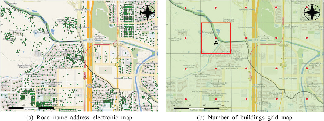
Table 1
Number of Buildings by Administrative District in Gyeonggi-do
Ž∂ĄžĄĚŪēīŽ≥ł Í≤įÍ≥ľ Ž™®Žď† žčúÍĶįžóźžĄú ŽŹĄŽ°úŽ™Öž£ľžÜĆ ž†ĄžěźžßÄŽŹĄŽ°ú žāįž†ēŪēú Í≤įÍ≥ľÍįÄ ÍĪīž∂ēŽ¨ľ Í≤©žěźžěźŽ£ĆŽ•ľ žā¨žö©Ūēú Í≤ÉŽ≥īŽč§ ÍĪīž∂ēŽ¨ľžąėÍįÄ ŪĀ¨Í≤Ć žāįž†ēŽźėžóąŽč§. žĄĪŽā®žčú, ÍĶįŪŹ¨žčúžĚė Í≤Ĺžöį Í≤įÍ≥ľÍįížĚė ŽĻĄžú® žį®žĚīÍįÄ 5% žĚīŽāīžĚīžßÄŽßĆ, žĚīž≤úžčú, žĖĎž£ľžčú, ÍįÄŪŹČÍĶįžĚÄ 100% žĚīžÉĀžĚė žį®žĚīŽ•ľ Ž≥īžėÄŽč§. Fig. 3žóźžĄúžôÄ ÍįôžĚī ÍĪīŽ¨ľžĚė žčúÍĶįŽ≥Ą žÜĆžÜćžó¨Ž∂ÄŽ•ľ ŪŹ¨žĚłŪ䳎•ľ Íłįž§ÄžúľŽ°ú ŪĆźž†ēŪēėŽ©ī ÍĪīŽ¨ľžĚī ÍįĚž≤īŽ≥ĄŽ°ú ÍĶ¨Ž∂ĄŽźú ŽŹĄŽ°úŽ™Öž£ľžÜĆ ž†ĄžěźžßÄŽŹĄŽäĒ ŪĖČž†ēÍ≤ĹÍ≥ĄŽ•ľ Íłįž§ÄžúľŽ°ú ž†ēŪôēŪěą Ž∂ĄŪē†ŽźúŽč§. ŪēėžßÄŽßĆ, Í≤©žěźžěźŽ£ĆžĚė Í≤Ĺžöį Fig. 3žĚė (b)žóź ŪĎúžčúŽźú A Í≤©žěźžôÄ ÍįôžĚī Žč§Ž•ł žßÄžěźž≤īžĚė ÍĪīž∂ēŽ¨ľŽŹĄ ŪŹ¨žĚłŪäłÍįÄ žÜĆžÜ掟ú žßÄžěźž≤īžĚė ÍĪīŽ¨ľŽ°ú žĚľÍīĄ ŪĆźž†ēŽźúŽč§. Ž≥ł žóįÍĶ¨žóźžĄúŽäĒ žĚīŽü¨Ūēú ŪäĻžĄĪŽď§žĚĄ Í≥†Ž†§Ūēėžó¨ ŽĎź Í≥ĶÍįĄŽ∂ĄžĄĚžěźŽ£ĆžĚė žį®žĚīŽ•ľ Ž≥īž†ēŪēīž£ľÍłį žúĄŪēī Žč®žąúžĄ†ŪėēŪöĆÍ∑ÄŽ∂ĄžĄĚžĚĄ ž†Āžö©ŪēėžėÄŽč§(Fig. 4, Table 2).
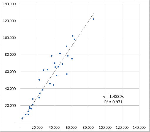
Table 2
Simple Linear Regression Analysis Result
| Regression Equation | R2 | F | p | RMSE |
|---|---|---|---|---|
| y = 1.4889x | 0.971 | 4.69336E-24 | 1.26793E-24 | 10,268 |
ŽŹÖŽ¶ĹŽ≥ÄžąėŽäĒ ÍĪīž∂ēŽ¨ľžąė Í≤©žěźžěźŽ£Ć(xž∂ē), žĘÖžÜćŽ≥ÄžąėŽäĒ ŽŹĄŽ°úŽ™Öž£ľžÜĆ ž†ĄžěźžßÄŽŹĄ(yž∂ē), yž†ąŪéłžĚÄ 0žúľŽ°ú žĄ§ž†ēŪēú Í≤įÍ≥ľ Í≤įž†ēÍ≥Ąžąė(R2)ÍįÄ 0.971žĚł ŪöĆÍ∑ÄžčĚžĚī ŽßƎ吏Ėīž°ĆŽč§. ŽßƎ吏ĖīžßĄ ŪöĆÍ∑ÄžčĚžĚÄ Fig. 4žôÄ ÍįôžĚī ŽÜížĚÄ ž†ĀŪē©ŽŹĄŽ•ľ Ž≥īžėÄžúľŽ©į, Íłįž°ī ÍĪīž∂ēŽ¨ľžąė Í≤©žěźžěźŽ£ĆžĚė ŪÜĶÍ≥ĄÍįížóź ŪöĆÍ∑Äžč̞̥ ž†Āžö©ŪĖąžĚĄ ŽēĆ ŽŹĄŽ°úŽ™Öž£ľžÜĆ ž†ĄžěźžßÄŽŹĄžĚė ŪÜĶÍ≥ĄÍįíÍ≥ľ žį®žĚīÍįÄ ÍįźžÜĆŪĖąžĚƞ̥ ŪôēžĚłŪēėžėÄŽč§. ÍĪīž∂ēŽ¨ľžąėŽäĒ žĄłŽ∂ÄžßÄŪĎúžĚė ŪäĻžĄĪžÉĀ žóįŽŹĄŽ≥Ą ŪÜĶÍ≥ĄŽüČžĚė Ž≥ÄŪôĒÍįÄ ŪĀ¨žßÄ žēäÍłį ŽēĆŽ¨łžóź Í≤ĹÍłįŽŹĄ žčúÍĶįžĚĄ ŽĆÄžÉĀžúľŽ°ú ŽŹĄŽ°úŽ™Öž£ľžÜĆ ž†ĄžěźžßÄŽŹĄ ŽĆÄžč† ÍĪīž∂ēŽ¨ľžąė Í≤©žěźžěźŽ£ĆŽ•ľ žā¨žö©ŪēėÍ≥†žěź ŪēúŽč§Ž©ī ŪöĆÍ∑Äžč̞̥ žā¨žö©Ūēú ŪÜĶÍ≥ĄÍįí Ž≥īž†ēžĚī ÍįÄŽä•ŪēėŽč§.
3.3 ŪĖČž†ēÍĶ¨žó≠Ž≥Ą žĻ®žąėŪĒľŪēī žėĀŪĖ•Ž≤ĒžúĄ Žāī ÍĪīž∂ēŽ¨ľžąė
Ž≥ł žóįÍĶ¨žóźžĄúŽäĒ Í≤ĹÍłįŽŹĄ žčúÍĶįŽ≥Ą žĻ®žąėŪĒľŪēī žėĀŪĖ•Ž≤ĒžúĄ Žāīžóź žúĄžĻėŪēú ÍĪīž∂ēŽ¨ľžĚĄ žĄ†Ž≥ĄŪēėÍłį žúĄŪēī ŪôėÍ≤ĹŽ∂ÄžôÄ ŪĖČž†ēžēąž†ĄŽ∂ÄžĚė žÉĀžúĄŽĻąŽŹĄ Ūēėž≤úžě¨Ūēī ŪôćžąėžúĄŪóėžßÄŽŹĄŽ•ľ žā¨žö©ŪēėžėÄŽč§. ÍĪīž∂ēŽ¨ľžĚī žĻ®žąėŪĒľŪēī žėĀŪĖ•Ž≤ĒžúĄ Žāīžóź Žď§žĖīžė§ŽäĒ ŪĆźž†ēžó¨Ž∂ÄŽäĒ ŪĖČž†ēÍĶ¨žó≠Ž≥Ą ŪĆźž†ēŽ≤ēÍ≥ľ Žßąžį¨ÍįÄžßÄŽ°ú ŪŹ¨žĚłŪäłžĚė ŪŹ¨Ūē®žó¨Ž∂ÄŽ•ľ Íłįž§ÄžúľŽ°ú ŪĆźž†ēŪēėžėÄŽč§. Fig. 5ŽäĒ žąėŽŹĄÍ∂Ć Žāīžóź žúĄžĻėŪēú ÍĶ≠ÍįÄŪēėž≤ú, žßÄŽį©Ūēėž≤ú, žÜĆŪēėž≤ú ŪôćžąėžúĄŪóėžßÄŽŹĄžĚė Ž∂ĄŪŹ¨Ž•ľ ŽāėŪÉÄŽāł Í≤ÉžĚīŽ©į, Table 3žĚÄ Í≤ĹÍłįŽŹĄ 31Íįú žčúÍĶįŽ≥Ą ŪôćžąėžúĄŪóėžßÄŽŹĄžôÄ ž§Ďž≤©Žźú ÍĪīž∂ēŽ¨ľžąėŽ•ľ ŽāėŪÉÄŽāł Í≤ÉžĚīŽč§.
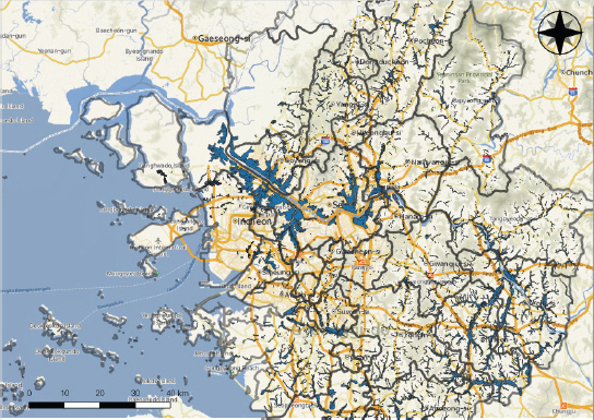
Table 3
Number of Buildings Within the Impact Range of Flood Damage by Administrative District in Gyeonggi-do
žēěžóźžĄú Í≤ĹÍłįŽŹĄ 31Íįú žčúÍĶįŽ≥Ą ÍĪīž∂ēŽ¨ľžąėŽ•ľ žāįž†ēŪĖąžĚĄ ŽēĆžóźŽäĒ Ž™®Žď† žčúÍĶįžóźžĄú ŽŹĄŽ°úŽ™Öž£ľžÜĆ ž†ĄžěźžßÄŽŹĄžĚė ŪÜĶÍ≥ĄÍįížĚī ÍĪīž∂ēŽ¨ľ Í≤©žěźžěźŽ£ĆŽ≥īŽč§ ŪĀ¨Í≤Ć žāįž†ēŽźėžóąŽč§. ŪēėžßÄŽßĆ ŪôćžąėžúĄŪóėžßÄŽŹĄžôÄ ž§Ďž≤©Žźú ÍĪīž∂ēŽ¨ľŽßĆ ž∂Ēž∂úŪĖąžĚĄ Í≤ĹžöįžóźŽäĒ Žč§Ž•ł Í≤įÍ≥ľÍįÄ ŽŹĄž∂úŽźėžóąŽäĒŽćį, Ž∂Äž≤úžčú, žóįž≤úÍĶį, žēąžĖĎžčú ŽďĪ 7ÍįúžĚė žčúÍĶįžóźžĄ† žė§Ū칎†§ ÍĪīž∂ēŽ¨ľ Í≤©žěźžěźŽ£ĆžĚė ŪÜĶÍ≥ĄÍįížĚī ŽŹĄŽ°úŽ™Öž£ľžÜĆ ž†ĄžěźžßÄŽŹĄŽ≥īŽč§ ŪĀ¨Í≤Ć žāįž†ēŽźėžóąŽč§. žĚīŽü¨Ūēú ŪėĄžÉĀžĚī ŽįúžÉĚŪēú žĚīžú†ŽäĒ ŪôćžąėžúĄŪóėžßÄŽŹĄžôÄ ž§Ďž≤© Žźú ŪŹ¨žĚłŪ䳎ßĆ ž∂Ēž∂úŪēú Í≤įÍ≥ľ ŽĆÄžÉĀ žßÄžěźž≤īžóźžĄú žÜĆÍ∑úŽ™® ŪŹ¨žĚłŪ䳎ßĆ ž∂Ēž∂úŽźėžóąžĚĄ Í≤Ĺžöį Í≤©žěźŽ≥Ą ŪŹ¨žĚłŪäł(ž§Ďžč¨ž†ź)žĚė ž§Ďž≤©žó¨Ž∂Äžóź ŽĒįŽĚľ žāįž†ēŽźėŽäĒ ŪÜĶÍ≥ĄÍįížĚė žį®žĚīÍįÄ ŪĀ¨Í≤Ć ŽįúžÉĚŪēėÍłį ŽēĆŽ¨łžĚīŽč§. žĻ®žąėŪĒľŪēī žėĀŪĖ•Ž≤ĒžúĄ Žāī ÍĪīž∂ēŽ¨ľžąė ŪÜĶÍ≥ĄÍįížĚė žį®žĚīŽ•ľ Ž≥īž†ēŪēīž£ľÍłį žúĄŪēī Žč®žąúžĄ†ŪėēŪöĆÍ∑ÄŽ∂ĄžĄĚžĚĄ ž†Āžö©Ūēú Í≤įÍ≥ľŽäĒ Fig. 6, Table 4žôÄ ÍįôŽč§.
Fig. 6
Simple Linear Regression Analysis for the Number of Buildings Within the Impact Range of Flood Damage

Table 4
Simple Linear Regression Analysis Result (2)
| Regression Equation | R2 | F | p | RMSE |
|---|---|---|---|---|
| y=1.4037x | 0.9337 | 7.80941E-19 | 3.13447E-19 | 1,268 |
Ž®ľž†Ä žßĄŪĖČŪĖąŽćė žĄ†ŪėēŪöĆÍ∑ÄŽ∂ĄžĄĚÍ≥ľ ŽŹôžĚľŪēú ž°įÍĪī ŪēėžóźžĄú Ž∂ĄžĄĚžĚĄ žßĄŪĖČŪēú Í≤įÍ≥ľ Í≤įž†ēÍ≥Ąžąė(R2)ÍįÄ 0.9337žĚł žĄ†ŪėēŪöĆÍ∑ÄžčĚžĚī ŽßƎ吏Ėīž°ĆŽč§. 31Íįú žčúÍĶį ž§Ď Í≥†žĖĎžčúžĚė Í≤Ĺžöį ÍĪīž∂ēŽ¨ľžąė ŪÜĶÍ≥ĄÍįížĚī ŪĀ¨Í≤Ć žāįž†ēŽźėžĖī Žč§Ž•ł žčúÍĶįŽď§žĚė Ž∂ĄŪŹ¨žôÄ žį®žĚīŽ•ľ Ž≥īžĚīžßÄŽßĆ, Fig. 6žóźžĄú ŪôēžĚłŪē† žąė žěąŽďĮžĚī ŪöĆÍ∑ÄžčĚžĚė ž†ĀŪē©ŽŹĄžóź ŪĀ¨Í≤Ć žėĀŪĖ•žĚĄ ž£ľžßĄ žēäžēėŽč§. Í≤ĹÍłįŽŹĄ žčúÍĶįžóźžĄú Í≤©žěźžěźŽ£ĆŽ°ú žĻ®žąėŪĒľŪēī žėĀŪĖ•Ž≤ĒžúĄ Žāī ÍĪīž∂ēŽ¨ľžąėŽ•ľ žāįž†ēŪē† Žēƞ󟎏Ą ŪēīŽčĻ ŪöĆÍ∑Äžč̞̥ ŪÜĶŪēī ŪÜĶÍ≥ĄÍįížĚĄ Ž≥īž†ēŪē† žąė žěąŽč§.
3.4 žĄłŽ∂ÄžßÄŪĎú(ÍĪīž∂ēŽ¨ľžąė) žßÄžąė ŽĻĄÍĶźŽ∂ĄžĄĚ
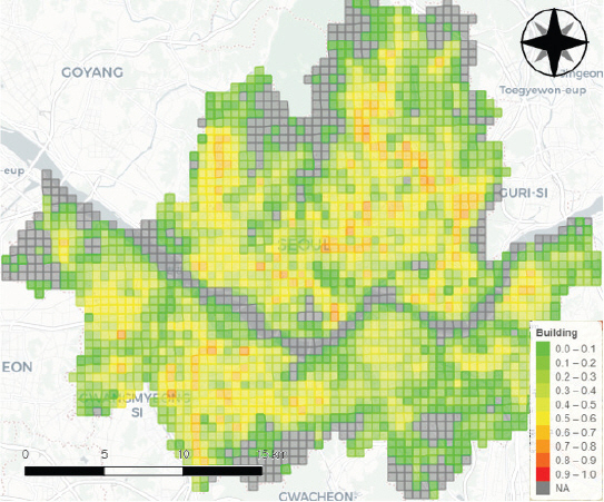
ŪôćžąėžúĄŪóėŽŹĄ ŪŹČÍįĞ󟞥ú žĄłŽ∂ÄžßÄŪĎúžóź ŽĆÄŪēú žßÄžąėŽ•ľ žāįž†ēŪēėŽäĒ Žį©Ž≤ēžúľŽ°úŽäĒ ŪĎúž§ÄŪôĒ, ÍĶ¨ÍįĄŽ≥Ą ž†źžąėŪôĒ ŽďĪ Žč§žĖĎŪēú Žį©Ž≤ēŽ°†žĚī žěąŽč§. Ž≥ł žóįÍĶ¨žóźžĄúŽäĒ žĄłŽ∂ÄžßÄŪĎú(ÍĪīž∂ēŽ¨ľžąė) žßÄžąėžĚė ž†ēÍ∑úžĄĪžĚĄ Í≥†Ž†§Ūēėžó¨ Eq. (1)Í≥ľ ÍįôžĚī ŽŹĄŽ°úŽ™Öž£ľžÜĆ ž†ĄžěźžßÄŽŹĄžôÄ Í≤©žěźžěźŽ£ĆžóźžĄú žßĎÍ≥ĄŪēú žßÄžěźž≤īŽ≥Ą ÍĪīž∂ēŽ¨ľžąė ŪÜĶÍ≥ĄÍįížĚĄ root Ž≥ÄŪôė ŪõĄ min-max ŪĎúž§ÄŪôĒŽ•ľ ž†Āžö©ŪēėžėÄŽč§.
min-max ŪĎúž§ÄŪôĒŽ•ľ ž†Āžö©Ūēėžó¨ žāįž†ēŪēú žßÄžąėŽäĒ 0‚ąľ1 žā¨žĚīžĚė ÍįížĚĄ ÍįÄžßÄŽ©į, žāįž†ēŽźú žßÄžąėŽ•ľ Íłįž§ÄžúľŽ°ú žßÄžěźž≤īŽ≥Ą ŪôćžąėžúĄŪóėžóź ŽÖłž∂úŽźú ÍĪīž∂ēŽ¨ľžąėŽ•ľ ŽĻĄÍĶźŪē† žąė žěąŽč§. Fig. 7žĚÄ žßÄžěźž≤īŽ≥Ą ŽŹĄŽ°úŽ™Öž£ľžÜĆ ž†ĄžěźžßÄŽŹĄžôÄ ÍĪīž∂ēŽ¨ľžąė Í≤©žěźžěźŽ£Ć(Ž≥īž†ēÍ≥Ąžąė ž†Āžö©)žĚė ÍĪīž∂ēŽ¨ľžąėŽ•ľ ŪĎúž§ÄŪôĒŪēėžó¨ ŪÜĶÍ≥ĄžßÄŽŹĄŽ°ú ŽāėŪÉÄŽāł Í≤ÉžĚīŽč§. ŽėźŪēú ŽŹôžĚľŪēú Žį©Ž≤ēžúľŽ°ú žĻ®žąėŪĒľŪēī žėĀŪĖ•Ž≤ĒžúĄ ŽāīžĚė ÍĪīž∂ēŽ¨ľžąėŽ•ľ ŪĎúž§ÄŪôĒŪēėžó¨ žěĎžĄĪŪēú ŪÜĶÍ≥ĄžßÄŽŹĄŽäĒ Fig. 8žĚīŽč§.
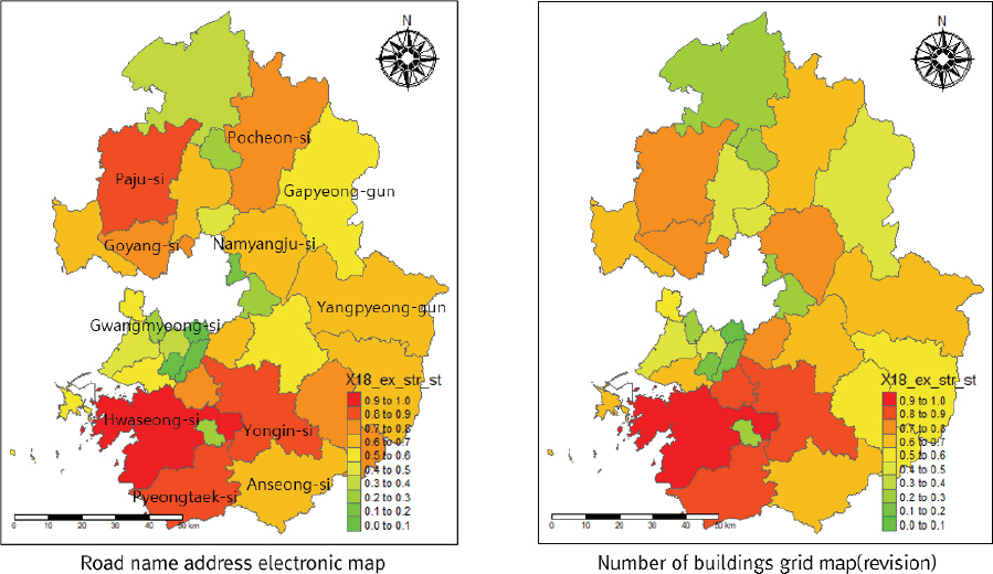
Fig. 8
Comparison of Standardization Index for the Number of Buildings using Overlapped Flood Hazard Map
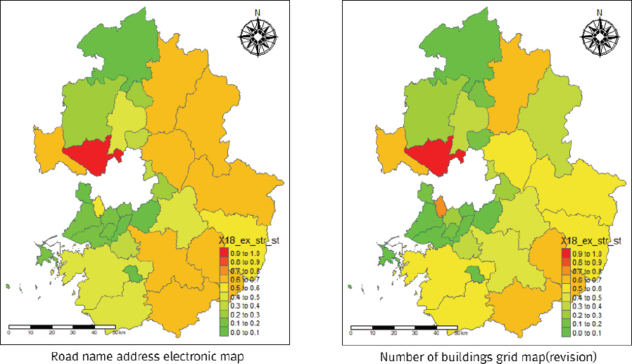
ŽĎź Í≥ĶÍįĄŽ∂ĄžĄĚžěźŽ£ĆžĚė ÍĪīž∂ēŽ¨ľžąėžóź ŽĆÄŪēú ŪĎúž§ÄŪôĒ žßÄžąėŽ•ľ žāįž†ēŪēú Í≤įÍ≥ľ Fig. 7žóźžĄúŽäĒ ŪĆĆž£ľžčú, ÍįÄŪŹČÍĶį, Žā®žĖĎž£ľžčú ŽďĪ žĚľŽ∂Ä žčúÍĶįžóźžĄú žį®žĚīŽ•ľ Ž≥īžėÄžúľŽ©į, Fig. 8žóźžĄúŽäĒ žö©žĚłžčú, žĖĎŪŹČÍĶį, Žā®žĖĎž£ľžčú ŽďĪžóźžĄú žį®žĚīÍįÄ ŽįúžÉĚŪēėžėÄŽč§. ŪēėžßÄŽßĆ Ž¨īžóáŽ≥īŽč§ ŽĎźŽďúŽü¨žßÄŽäĒ žį®žĚīŽäĒ Fig. 7Í≥ľ Fig. 8 žā¨žĚīžĚė ŽĻĄÍĶźžóźžĄú ŽįúžÉĚŪēėŽäĒŽćį, Žč®žąúŪěą ŽĆÄžÉĀ žčúÍĶįŽ≥Ą žīĚ ÍĪīž∂ēŽ¨ľžąėŽ•ľ ŽāėŪÉÄŽāł Fig. 7Í≥ľŽäĒ Žč¨Ž¶¨ Fig. 8žóźžĄúŽäĒ ŪôćžąėžúĄŪóėžßÄŽŹĄžôÄ ž§Ďž≤©Žźú ÍĪīž∂ēŽ¨ľ žąėŽßĆ ŪÜĶÍ≥ĄÍįížóź ŽįėžėĀŪĖąÍłį ŽēĆŽ¨łžóź ŪôćžąėžúĄŪóėžĚī ŽÜížĚÄ žčúÍĶįžĚė ŪĎúž§ÄŪôĒ žßÄžąėÍįÄ ŪĀ¨Í≤Ć žāįž†ēŽźúŽč§. ž¶Č Fig. 7žóźžĄúŽäĒ Í≤ĹÍłįŽŹĄ žčúÍĶį ž§Ď ÍĪīž∂ēŽ¨ľžąėÍįÄ ŽßéžĚÄ ŪôĒžĄĪžčú, žö©žĚłžčú, ŪŹČŪÉĚžčú ŽďĪžóźžĄú žßÄžąėÍįÄ ŪĀ¨Í≤Ć žāįž†ēŽźú ŽįėŽ©ī, Fig. 8žóźžĄúŽäĒ ŪôćžąėžúĄŪóėžóź ŽÖłž∂úŽźú ÍĪīŽ¨ľžĚī ŽßéžĚÄ Í≥†žĖĎžčú, ŪŹ¨ž≤úžčú, žēąžĄĪžčú ŽďĪžĚė žßÄžěźž≤īžóźžĄú žßÄžąėÍįÄ ŪĀ¨Í≤Ć žāįž†ēŽźėžóąŽč§. Ž≥ł žóįÍĶ¨žóźžĄú žĄúŽ°ú Žč§Ž•ł žú†ŪėēžĚė ŪÜĶÍ≥ĄžěźŽ£ĆŽ•ľ žā¨žö©Ūēėžó¨ ŽŹĄž∂úŽźú Í≤įÍ≥ľŽ•ľ ŽĻĄÍĶźŪĖąžĚĄ ŽēĆ ŪôćžąėžúĄŪóėžßÄŽŹĄžôÄ ž§Ďž≤©Žźú ÍĪīž∂ēŽ¨ľžąėŽ°ú žßĎÍ≥ĄŪēú ŪÜĶÍ≥ĄÍįížĚī ŪôćžąėžúĄŪóėŽŹĄŽ•ľ ŪŹČÍįÄŪēėŽäĒŽćį ŽćĒ ŪÉÄŽčĻžĄĪžĚī ŽÜížĚƞ̥ ŪôēžĚłŪē† žąė žěąžóąŽč§.
4. Í≤į Ž°†
ž†Ą žßÄÍĶ¨ž†Ā ÍłįŪõĄŽ≥ÄŪôĒžĚė žėĀŪĖ•žúľŽ°ú 2020ŽÖĄžóźŽŹĄ žßĎž§ĎŪėłžöį ŽįŹ ŪÉúŪíć ŪĒľŪēīÍįÄ ŪĀ¨Í≤Ć ŽįúžÉĚŪē®žóź ŽĒįŽĚľ ž§Ďžēôž†ēŽ∂Ä ŽįŹ žßÄžěźž≤īžóźžĄúŽäĒ ŪôćžąėžúĄŪóėžóź ŽĆÄŪēú ÍīĞ訞Ěī ŽÜížēĄžßÄÍ≥† žěąŽč§. ž†ēŽ∂Ğ󟞥úŽäĒ žßÄžěźž≤īŽ≥Ą žě¨Žāúžóź ŽĆÄŪēú žúĄŪóėŽŹĄŽ•ľ ŪŹČÍįÄŪēėÍłį žúĄŪēī žßÄžó≠žēąž†ĄžßÄžąė, žßÄžó≠žēąž†ĄŽŹĄ ŪŹČÍįÄ ŽďĪžĚĄ žčúŪĖČŪēėÍ≥† žěąžßÄŽßĆ, Ūôćžąėžóź ŽĆÄŪēú žúĄŪóėŽŹĄŽ•ľ Ž≥īžó¨ž£ľŽäĒ ŽćįžóźŽäĒ žó¨Žü¨ ÍįÄžßÄ Ž≥īžôĄž†źžĚĄ ÍįÄžßÄÍ≥† žěąŽč§. Ž≥ł žóįÍĶ¨žóźžĄúŽäĒ Í≤©žěźŽč®žúĄ Í≥ĶÍįĄŽ∂ĄžĄĚžěźŽ£ĆžôÄ ŪôćžąėžúĄŪóėžßÄŽŹĄŽ•ľ Ūôúžö©Ūēú Ž∂ĄžĄĚžóźžĄú Žč§žĚĆÍ≥ľ ÍįôžĚÄ žčúžā¨ž†źžĚĄ žĖĽžĚĄ žąė žěąžóąŽč§.
ž≤ęžßłŽäĒ ŪôćžąėžúĄŪóėŽŹĄ ŪŹČÍįĞ󟞥ú Í≤©žěźŽč®žúĄ Í≥ĶÍįĄŽ∂ĄžĄĚžěźŽ£ĆžĚė žú†žö©Ūē®žĚīŽč§. žßÄžěźž≤īŽ≥Ą ÍĪīž∂ēŽ¨ľžąė žāįž†ēžóźžĄúŽäĒ ŽŹĄŽ°úŽ™Öž£ľžÜĆ ž†ĄžěźžßÄŽŹĄŽ•ľ žā¨žö©ŪēėŽäĒ Í≤ÉžĚī ÍĪīž∂ēŽ¨ľžąė Í≤©žěźžěźŽ£ĆŽ≥īŽč§ ž†ēŪôēŪēú ŪÜĶÍ≥ĄÍįí žāįž†ēžĚī ÍįÄŽä•ŪēėžßÄŽßĆ žěźŽ£Ć ÍįÄÍ≥Ķ ŽįŹ Í≤įÍ≥ľÍįí žāįž†ēžóź žĖīŽ†§žõÄžĚī ŪĀ¨Žč§. žėąŽ•ľ Žď§žĖī Ž≥ł žóįÍĶ¨žóźžĄú žā¨žö©Ūēú Í≤ĹÍłįŽŹĄ ŽŹĄŽ°úŽ™Öž£ľžÜĆ ž†ĄžěźžßÄŽŹĄŽäĒ 160ŽßĆÍįú žĚīžÉĀžĚė ÍĪīŽ¨ľ ŪŹīŽ¶¨Í≥§žĚĄ ÍįÄžßÄÍ≥† žěąŽäĒŽćį ŽßĆžēĹ žóįÍĶ¨Ž≤ĒžúĄŽ•ľ žĄúžöłŪäĻŽ≥ĄžčúŽ•ľ ŪŹ¨Ūē®Ūēú ž†ĄÍĶ≠ žßÄžěźž≤īŽ°ú ŪôēŽĆÄŪēúŽč§Ž©ī žěĎžóÖ ŽāúžĚīŽŹĄŽäĒ ŪĀ¨Í≤Ć žÉĀžäĻŪēúŽč§. ŽįėŽ©ī ÍĪīž∂ēŽ¨ľžąė Í≤©žěźžěźŽ£ĆŽäĒ ŽŹĄŽ°úŽ™Öž£ľžÜĆ ž†ĄžěźžßÄŽŹĄ ŽĆÄŽĻĄ žěźŽ£ĆÍįÄÍ≥Ķ ŽįŹ ŪÜĶÍ≥ĄÍįí žāįž†ēžĚī ÍįĄŪéłŪēėÍ≥† ŪÜĶÍ≥ĄžßÄŽŹĄŽ•ľ žěĎžĄĪŪēėžó¨ žĚėžā¨Í≤įž†ēžĚĄ žßÄžõźŪē† žąė žěąÍłį ŽēĆŽ¨łžóź ŪôćžąėžúĄŪóėŽŹĄ ŪŹČÍįÄžóź ž†ĀŪē©ŪēėŽč§.
ŽĎėžßłŽäĒ žĻ®žąėŪĒľŪēī žėĀŪĖ•Ž≤ĒžúĄ Žāī ŪÜĶÍ≥ĄÍįí žā¨žö©žĚė ŪÉÄŽčĻžĄĪžĚīŽč§. Íłįž°ī ŪôćžąėžúĄŪóėŽŹĄ ŪŹČÍįĞ󟞥ú žā¨žö©ŪēėŽäĒ ŪÜĶÍ≥ĄžěźŽ£ĆŽäĒ ŪÜĶÍ≥ĄžóįŽ≥ī, žě¨ŪēīžóįŽ≥ī ŽďĪžóźžĄú žĖĽžĚÄ ŪÜĶÍ≥ĄÍįížĚĄ ÍįÄÍ≥Ķ žóÜžĚī Í∑łŽĆÄŽ°ú žā¨žö©ŪēėÍłį ŽēĆŽ¨łžóź ŪôćžąėŪĒľŪēīžóź ŽĆÄŪēú žóįÍīÄžĄĪžóź žĚėŽ¨łžĚī ž†úÍłįŽźėžĖī žôĒŽč§. ŪēėžßÄŽßĆ Ž≥ł žóįÍĶ¨žóźžĄúž≤ėŽüľ ŪôćžąėžúĄŪóėžßÄŽŹĄžôÄ Í≤©žěźžěźŽ£ĆŽ•ľ žā¨žö©Ūēėžó¨ ŪÜĶÍ≥ĄÍįížĚĄ žĄ†Ž≥ĄŪēėŽ©ī žóįŽŹĄŽ≥ĄŽ°ú ŪôćžąėžúĄŪóėžóź ž∑®žēĹŪēú žßÄžěźž≤īŽ•ľ ŪŹČÍįÄŪēėŽäĒ Žćį ŪÉÄŽčĻŪēú žßÄŪĎúÍįÄ Žź† žąė žěąŽč§.
žÖčžßłŽäĒ ŽŹĄŽ°úŽ™Öž£ľžÜĆ ž†ĄžěźžßÄŽŹĄžôÄ ÍĪīž∂ēŽ¨ľžąė Í≤©žěźžßÄŽŹĄžĚė ŪÜĶÍ≥ĄÍįí ŽĻĄÍĶźŽ∂ĄžĄĚžĚĄ ŪÜĶŪēī žė§žį®Ž•ľ Ž≥īž†ēŪē† ŪöĆÍ∑Äžč̞̥ ŽįúÍ≤¨Ūēú ž†źžĚīŽč§. ÍĪīž∂ēŽ¨ľžąė Í≤©žěźžßÄŽŹĄŽäĒ ŽŹĄŽ°úŽ™Öž£ľžÜĆ ž†ĄžěźžßÄŽŹĄ ŽĆÄŽĻĄ žěźŽ£ĆžĚė ÍįÄÍ≥Ķ ŽįŹ ŪÜĶÍ≥ĄžßÄŽŹĄ žěĎžĄĪžóź žú†žö©ŪēėžßÄŽßĆ Í≤©žěźžěźŽ£ĆÍįÄ ÍįĞߥ ŪäĻžĄĪ ŽēĆŽ¨łžóź ŽŹôžĚľŪēú Íłįž§Ä žčúž†źžóźžĄú žč§ž†ú ÍĪīž∂ēŽ¨ľžąėžôÄ žį®žĚīÍįÄ žěąŽč§ŽäĒ ŪēúÍ≥ĄŽ•ľ ÍįÄžßÄÍ≥† žěąŽč§. ŽĒįŽĚľžĄú Ž≥ł žóįÍĶ¨žóźžĄú ž†úžčúŪēú Í≤ĹÍłįŽŹĄ žčúÍĶįŽ≥Ą Ž≥īž†ēÍ≥ĄžąėŽ•ľ ž†Āžö©ŪēėŽ©ī Í≤©žěźŽč®žúĄ ŪÜĶÍ≥ĄÍįížĚė žė§žį®Ž•ľ Ž≥īž†ēŪē† žąė žěąŽč§.
Ž≥ł žóįÍĶ¨žóźžĄúŽäĒ IBA ŪŹČÍįÄŽį©Ž≤ēžĚĄ Íłįž§ÄžúľŽ°ú Exposure Ūē≠Ž™©žóź ŪēīŽčĻŪēėŽäĒ ÍĪīž∂ēŽ¨ľžąėŽ•ľ ŽĆÄžÉĀžúľŽ°ú Í≤ĹÍłįŽŹĄ žßÄžěźž≤īŽ≥Ą ŪôćžąėžúĄŪóėŽŹĄ ŪŹČÍįÄŽ•ľ žąėŪĖČŪēėžėÄŽč§. ŪēėžßÄŽßĆ, ŪėĄžě¨ ÍĶ≠Ū܆ž†ēŽ≥īŪĒĆŽěęŪŹľžóźžĄúŽäĒ ÍĪīž∂ēŽ¨ľžąė žôłžóźŽŹĄ žī̞̳ÍĶ¨žąė, Í≥ĶžčúžßÄÍįÄ, žú†žēĄ‚čÖÍ≥†Ž†Ļ žĚłÍĶ¨žąė ŽďĪ Žč§žĖĎŪēú žčúÍĶįÍĶ¨Ž≥Ą ŪÜĶÍ≥ĄÍįížĚĄ Í≤©žěźžěźŽ£Ć ŪėēŪÉúŽ°ú ž†úÍ≥ĶŪēėÍ≥† žěąŽč§. žĚīŽ•ľ žĚĎžö©Ūēėžó¨ ž∂ĒŪõĄ žóįÍĶ¨žóźžĄú ŪôćžąėžúĄŪóėŽŹĄŽ•ľ Hazard, Exposure, Vulnerability, Capacity Ūē≠Ž™©žúľŽ°ú ÍĶ¨žĄĪŪēėÍ≥† Í≤©žěźžěźŽ£ĆŽ•ľ Ūôúžö©Ūēú žßÄžěźž≤īŽ≥Ą ŪôćžąėžúĄŪóėŽŹĄŽ•ľ ŪŹČÍįÄŪēúŽč§Ž©ī ŽćĒ ŽāėžĚÄ Í≤įÍ≥ľŽ•ľ žĖĽžĚĄ žąė žěąžĚĄ Í≤ÉžĚīŽč§.


