1. м„ң лЎ
мҡ°лҰ¬лӮҳлқјлҠ” кё°нӣ„ліҖнҷ”мқҳ мҳҒн–ҘмңјлЎң мһҘл§Ҳкё°к°„мқҙ 짧아м§Җкі мқҙлЎҖм Ғмқё к°•мҲҳк°Җ л°ңмғқн•ҳл©°, көӯм§Җм Ғ к°•мҲҳн”јн•ҙк°Җ мҰқк°Җн•ҳкі мһҲлӢӨ(KMA, 2019). мөңк·ј 10л…„к°„ нҳёмҡ°мҷҖ нғңн’ҚмңјлЎң м—°нҸүк· 3мІңм–ө мӣҗмқҙ л„ҳлҠ” н”јн•ҙлҘј мһ…м—Ҳкі , мқҙлҠ” м „мІҙ мһҗм—°мһ¬н•ҙ н”јн•ҙм•Ўмқҳ м•Ҫ 90%лҘј м°Ём§Җн•ҳлҠ” кёҲм•ЎмқҙлӢӨ(MOIS, 2019). IPCC 5м°Ё ліҙкі м„ңм—җ л”°лҘҙл©ҙ, лҸҷм•„мӢңм•„м§Җм—ӯ лҢҖл¶Җ분 мӢңлӮҳлҰ¬мҳӨк°Җ к°•мҲҳлҹү л°Ҹ к·№н•ң к°•мҲҳнҳ„мғҒмқҳ л°ңмғқл№ҲлҸ„ мҰқк°ҖлҘј мҳҲмёЎн•ңлӢӨ(IPCC, 2014). мқҙлҹ¬н•ң кё°нӣ„ліҖнҷ”м—җ л”°лҘё н”јн•ҙлҠ” лҸ„мӢңм§Җм—ӯм—җм„ң лҚ”мҡұ мҰқк°Җн• кІғмңјлЎң м „л§қлҗҳлҠ”лҚ°, мқҙлҠ” л¶ҲнҲ¬мҲҳлҸ„к°Җ лҶ’м•„ лҸҷмқј к°•мҲҳлҹү лҢҖ비 лҚ” нҒ° м№ЁмҲҳм§Җм—ӯмқҙ л°ңмғқн•ҳкі , мқёкө¬ л°Ҹ кұҙ축물мқҳ л°Җ집лҸ„к°Җ лҶ’кё° л•Ңл¬ёмқҙлӢӨ(Jah et al., 2012; Ha and Jung, 2017; Mahmoud and Gan, 2018; Zhou et al., 2019).
лҸ„мӢңнҷҚмҲҳмқҳ мҳҲл°©лҢҖмұ…мҲҳлҰҪ л°Ҹ н”јн•ҙліөкө¬лҘј мң„н•ҙм„ңлҠ” мӢ мҶҚн•ң м№ЁмҲҳм§Җм—ӯ мЎ°мӮ¬к°Җ мӨ‘мҡ”н•ҳлӢӨ. мһҗм—°мһ¬н•ҙлҢҖмұ…лІ•мқҖ мқҙмҷҖ кҙҖл Ён•ҳм—¬ м№ЁмҲҳнқ”м ҒлҸ„лҘј мһ‘м„ұн•ҳлҸ„лЎқ к·ңм •н•ҳкі мһҲмңјлӮҳ м№ЁмҲҳм§Җм—ӯмқҙ кҙ‘лІ”мң„н•ҳкі м№ЁмҲҳ нӣ„ л°°мҲҳк°Җ л№ лҘҙкІҢ 진н–үлҗҳлҜҖлЎң м№ЁмҲҳм§Җм—ӯмқ„ мҷ„лІҪн•ҳкІҢ мЎ°мӮ¬н•ҳкё°м—җлҠ” мҳҲмӮ° л°Ҹ мқёл Ҙл¶ҖмЎұ л“ұмңјлЎң мқён•ң н•ңкі„к°Җ мһҲлӢӨ. лҳҗн•ң, м№ЁмҲҳнқ”м ҒлҸ„лҠ” мһ¬н•ҙл°ңмғқмқҳ лӢӨмқҢн•ҙм—җ кіөмӢқ л°ңк°„лҗҳлҜҖлЎң мһ¬н•ҙм—җ л”°лҘё мӢ мҶҚн•ң лҢҖмқ‘ л°Ҹ кҙҖлҰ¬к°Җ м–ҙл өлӢӨ(Goo et al., 2011; Lim et al., 2016).
м№ЁмҲҳм§Җм—ӯмқ„ мЎ°мӮ¬н•ҳкё° мң„н•ң лҢҖм•ҲмңјлЎң мөңк·ј мқёкіөмң„м„ұ мқҙлҜём§ҖлҘј нҷңмҡ©н•ң м№ЁмҲҳм§Җм—ӯмӮ°м •л°©лІ•мқҙ кҙҖмӢ¬мқ„ л°ӣкі мһҲлӢӨ. мң„м„ұмҳҒмғҒмқҖ мҲҳл°ұ нӮ¬лЎңлҜён„°м—җ кұём№ң кҙ‘лІ”мң„н•ң мҳҒм—ӯмқ„ мқјмӢңм—җ мҙ¬мҳҒн• мҲҳ мһҲлӢӨлҠ” м җмқҙ нҠ№м§•мқҙлӢӨ. мң„м„ұмҳҒмғҒмқ„ нҷңмҡ©н•ң м№ЁмҲҳм§Җм—ӯмқҳ нҢҗлі„л°©лІ•мқҖ нҒ¬кІҢ лӢӨмқҢмқҳ м„ё к°Җм§ҖлЎң лӮҳлҲҢ мҲҳ мһҲлӢӨ(Brivio et al., 2002).
(1) м№ЁмҲҳ нӣ„ мң„м„ұмҳҒмғҒмқ„ 분м„қн•ҳм—¬ мҲҳкі„лҘј 추м¶ңн•ҳм—¬ м№ЁмҲҳм§Җм—ӯмқ„ м¶”м •н•ҳлҠ” л°©лІ•(Di Baldassarre et al., 2009; Notti et al., 2018; Schumann et al., 2014).
(2) л‘җ к°ң мқҙмғҒмқҳ мң„м„ұмҳҒмғҒ мқҙлҜём§ҖлҘј 비көҗн•ҳм—¬ м№ЁмҲҳм§Җм—ӯмқ„ мӮ°м •н•ҳлҠ” л°©лІ•(Lee et al., 2004; Kim et al., 2007; Shin et al., 2012; Hwang et al., 2016; Perrou et al., 2018).
(3) Interferometry Synthetic aperture radar (InSAR)мқҳ кёҙл°ҖлҸ„(coherence)лҘј нҷңмҡ©н•ң м№ЁмҲҳм§Җм—ӯ м¶”м •л°©лІ•(Geudtner et al., 1996; Refice et al., 2014).
н•ңнҺё мң„м„ұмҳҒмғҒмһҗлЈҢлҠ” кёҙ мҙ¬мҳҒмЈјкё°лЎң мқён•ҳм—¬ м •нҷ•н•ң м№ЁмҲҳк·ңлӘЁмқҳ мӮ°м •м—җ м–ҙл ӨмӣҖмқҙ мһҲлӢӨ. мқҙ л¬ём ңлҘј н•ҙкІ°н•ҳкё° мң„н•ҳм—¬ м№ЁмҲҳл°ңмғқ мҲҳ мӢңк°„ нӣ„ мҙ¬мҳҒлҗң мң„м„ұмҳҒмғҒкіј м§Җнҳ•мһҗлЈҢлҘј лҸҷмӢңм—җ нҷңмҡ©н•ң м—°кө¬к°Җ нҷңл°ңнһҲ 진н–үлҗҳкі мһҲлӢӨ.
Brivio et al. (2002)лҠ” 1994л…„ 11мӣ” мқҙнғҲлҰ¬м•„ Piemonte м§Җм—ӯм—җм„ң л°ңмғқн•ң нҷҚмҲҳн”јн•ҙлҘј ERS-1 мң„м„ұмҳҒмғҒкіј м§Җнҳ•мһҗлЈҢлҘј нҷңмҡ©н•ҳм—¬ нҷҚмҲҳк·ңлӘЁлҘј м¶”м •н•ҳмҳҖлӢӨ. м—¬кё°м„ң мң„м„ұмҳҒмғҒмһҗлЈҢлҠ” 20% м •лҸ„мқҳ м№ЁмҲҳнқ”м Ғл§Ң лӮЁмқҖ мғҒнғңмқҙм§Җл§Ң cost-distance л°©лІ•мқ„ нҷңмҡ©н•ҳм—¬ л§Өмҡ° лҶ’мқҖ м •нҷ•лҸ„лЎң мӢӨм ң м№ЁмҲҳм§Җм—ӯмқ„ м¶”м •н•ҳмҳҖлӢӨ. Chae (2005)лҠ” 2000л…„ л©”мҪ©к°• мң м—ӯмқҳ Tonle Sapнҳём—җм„ң л°ңмғқн•ң нҷҚмҲҳн”јн•ҙлҘј Landsat ETM+мҷҖ RADARSAT мң„м„ұмҳҒмғҒмңјлЎң cost-distanceкё°лІ•мқ„ мқҙмҡ©н•ҳм—¬ нҷҚмҲҳлІ”лһҢ л©ҙм Ғмқ„ 분м„қн•ҳмҳҖкі , мқҙлҘј DEMкіј мӨ‘мІ©мқ„ нҶөн•ҙ нҷҚмҲҳлҹүмқ„ кі„мӮ° нӣ„, мҲҳлҰ¬лӘЁнҳ• MIKEмқҳ кІ°кіјмҷҖ 비көҗн•ЁмңјлЎңмҚЁ мң мӮ¬м„ұмқ„ нҷ•мқён•ҳмҳҖлӢӨ. Frey et al. (2012) лҳҗн•ң cost-distance л°©лІ•мңјлЎң 2009л…„ Namibia Chobeк°•мқҳ лІ”лһҢмқ„ RapidEye мң„м„ұмҳҒмғҒкіј 분м„қн•ЁмңјлЎң м •нҷ•м„ұмқ„ н–ҘмғҒмӢңмј°лӢӨ. Liu et al. (2018)мқҖ Landsat-8, SPOT-5 мң„м„ұмҳҒмғҒкіј DEMмһҗлЈҢлҘј нҷңмҡ©н•ҳм—¬ мӨ‘көӯ Sanjiang Plainмқҳ Honghe National Natural Reserve (HNNR) мҠөм§Җм§Җм—ӯ лІ”лһҢмқ„ 분м„қн•ҳмҳҖлӢӨ. Wang (2004)кіј Wang et al. (2002)мқҖ Landsat 7 TMмқ„ DEMкіј нҷңмҡ©н•ҳм—¬ North Carolina м§Җм—ӯмқҳ 1999л…„ нҷҚмҲҳн”јн•ҙлҘј 분м„қн•ҳмҳҖмңјл©°, м Җм§ҖлҢҖ мҲІмқҳ нҷҚмҲҳлҘј мӢқлі„н•ҳлҠ”лҚ° лҸ„мӣҖмқҙ лҗҳлҠ” кІғмқ„ нҷ•мқён•ҳмҳҖлӢӨ.
мқҙлҹ¬н•ң м„ н–үм—°кө¬л“ӨмқҖ нҢҗлі„лҗң м№ЁмҲҳлІ”мң„лҘј кІҖмҰқн•ҳм§Җ м•Ҡкұ°лӮҳ, кІҖмҰқмһҗлЈҢлЎң лӘЁнҳ•мқҳ кІ°кіјлҘј нҷңмҡ©н•ҳмҳҖлӢӨлҠ” м җм—җм„ң н•ңкі„м җмқ„ к°Җм§Җкі мһҲлӢӨ. мқҙл“Өкіј 비көҗн•ҳм—¬ ліё м—°кө¬лҠ” лӢӨмқҢкіј к°ҷмқҖ м җм—җм„ң м°Ёлі„м„ұмқ„ к°Җ진лӢӨ.
(1) мқёкіөмң„м„ұкіј м§Җнҳ•мһҗлЈҢлҘј лҸҷмӢңм—җ нҷңмҡ©н•ҳм—¬ лҚ”мҡұ м •нҷ•н•ң м№ЁмҲҳм§Җм—ӯмқ„ нҢҗлі„н•ҳкі мһҗ н•ҳмҳҖлӢӨ.
(2) CCTV мһҗлЈҢлҘј 분м„қн•ҳм—¬ м№ЁмҲҳм§Җм—ӯмқҳ м°ёк°’мқ„ м–»м—Ҳмңјл©°, мқҙлҘј мқёкіөмң„м„ұ кё°л°ҳ м№ЁмҲҳм§Җм—ӯмқҳ кІҖмҰқм—җ нҷңмҡ©н•ҳмҳҖлӢӨ.
ліё м—°кө¬лҠ” мқҙлҹ¬н•ң л°©лІ•лЎ мқ„ нҶөн•ҙ мқёкіөмң„м„ұкё°л°ҳ м№ЁмҲҳм§Җм—ӯмӮ°м •кё°лІ•мқҳ мӢӨл¬ҙнҷңмҡ©м„ұмқ„ м •лҹүнҷ”н• мҲҳ мһҲм—ҲлӢӨ.
2. м—°кө¬ л°©лІ•
2.1 м—°кө¬лҢҖмғҒм§Җ
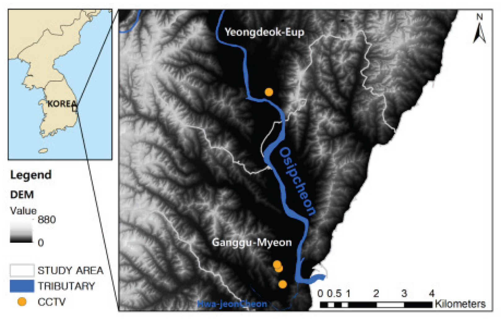
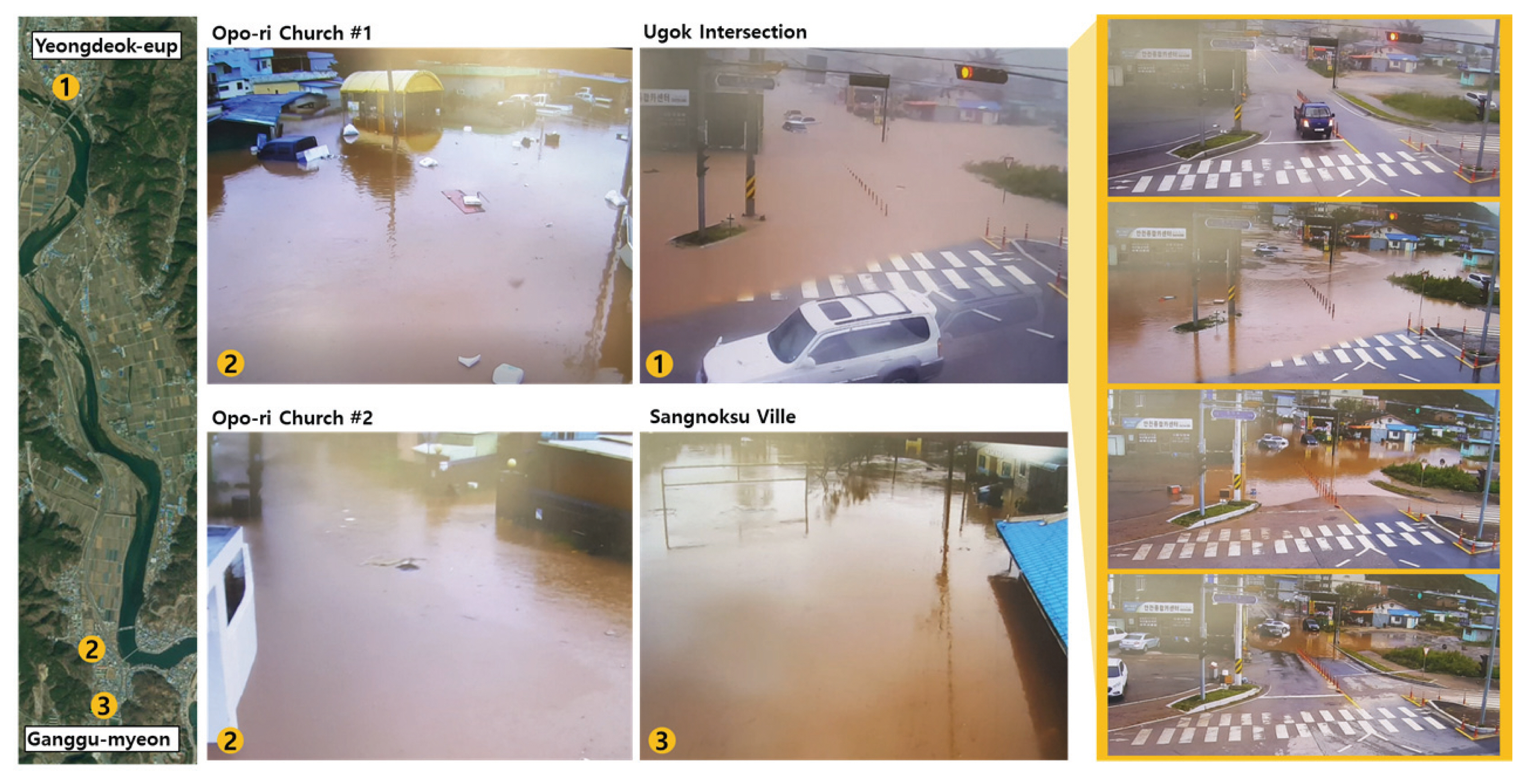
ліё м—°кө¬м—җм„ңлҠ” 2018л…„ 10мӣ” 5~6мқј нғңн’Қ мҪ©л Ҳмқҙ(KONG- REY)мқҳ м§Ғм ‘м Ғмқё мҳҒн–ҘмңјлЎң м•Ҫ 549м–ө мӣҗмқҳ мһ¬мӮ°н”јн•ҙк°Җ л°ңмғқн•ң кІҪмғҒлҸ„ мқјлҢҖм§Җм—ӯ мӨ‘ кІҪмғҒл¶ҒлҸ„ мҳҒлҚ•кө° м§Җм—ӯмқ„ лҢҖмғҒм§ҖлЎң м„ м •н•ҳмҳҖлӢӨ(Fig. 1).
мқҙ кё°к°„ лҸҷм•Ҳ 10мӣ” мҳҒлҚ•кө° нҸүл…„ к°•мҲҳлҹү(53.2 mm, 1981л…„-2010л…„)мқҳ м•Ҫ 6л°°м—җ н•ҙлӢ№н•ҳлҠ” 313.5 mmмқҳ к°•мҲҳк°Җ л°ңмғқн•ҳмҳҖлӢӨ. лҳҗн•ң, мқј мөңлҢҖ 242 mm/day, мӢңк°„мөңлҢҖ 44 mm/hr (AWS мҳҒлҚ•мқҚ кҙҖмёЎмҶҢ кё°мӨҖ)лЎң кё°лЎқм Ғмқё к°•мҲҳк°Җ л°ңмғқн•Ём—җ л”°лқј мЈјнғқ, мғҒк°Җ л“ұм—җ м№ЁмҲҳн”јн•ҙлҘј мһ…м—ҲлӢӨ. нҠ№нһҲ мҳҒлҚ•мқҚмқҳ кІҪмҡ° мӨ‘м•ҷмқ„ к°ҖлЎңм§ҖлҘҙлҠ” м§Җл°© 2кёү н•ҳмІңмқё мҳӨмӢӯмІңмқҳ лІ”лһҢмңјлЎң м Җм§ҖлҢҖ м§Җм—ӯкіј мЈјліҖ л…јвҖӨл°ӯмқҙ м№ЁмҲҳлҗҳм—Ҳмңјл©°, к°•кө¬л©ҙмқҳ кІҪмҡ° мҳӨмӢӯмІң н•ҳлҘҳм—җм„ң н•©лҘҳлҗҳлҠ” мҶҢн•ҳмІңмқё нҷ”м „мІңмқҳ лІ”лһҢм—җ л”°лқј 1 mк°Җ л„ҳлҠ” м№ЁмҲҳмӢ¬мқҙ л°ңмғқн•ҳмҳҖлӢӨ.
2.2 мң„м„ұмҳҒмғҒ DATA
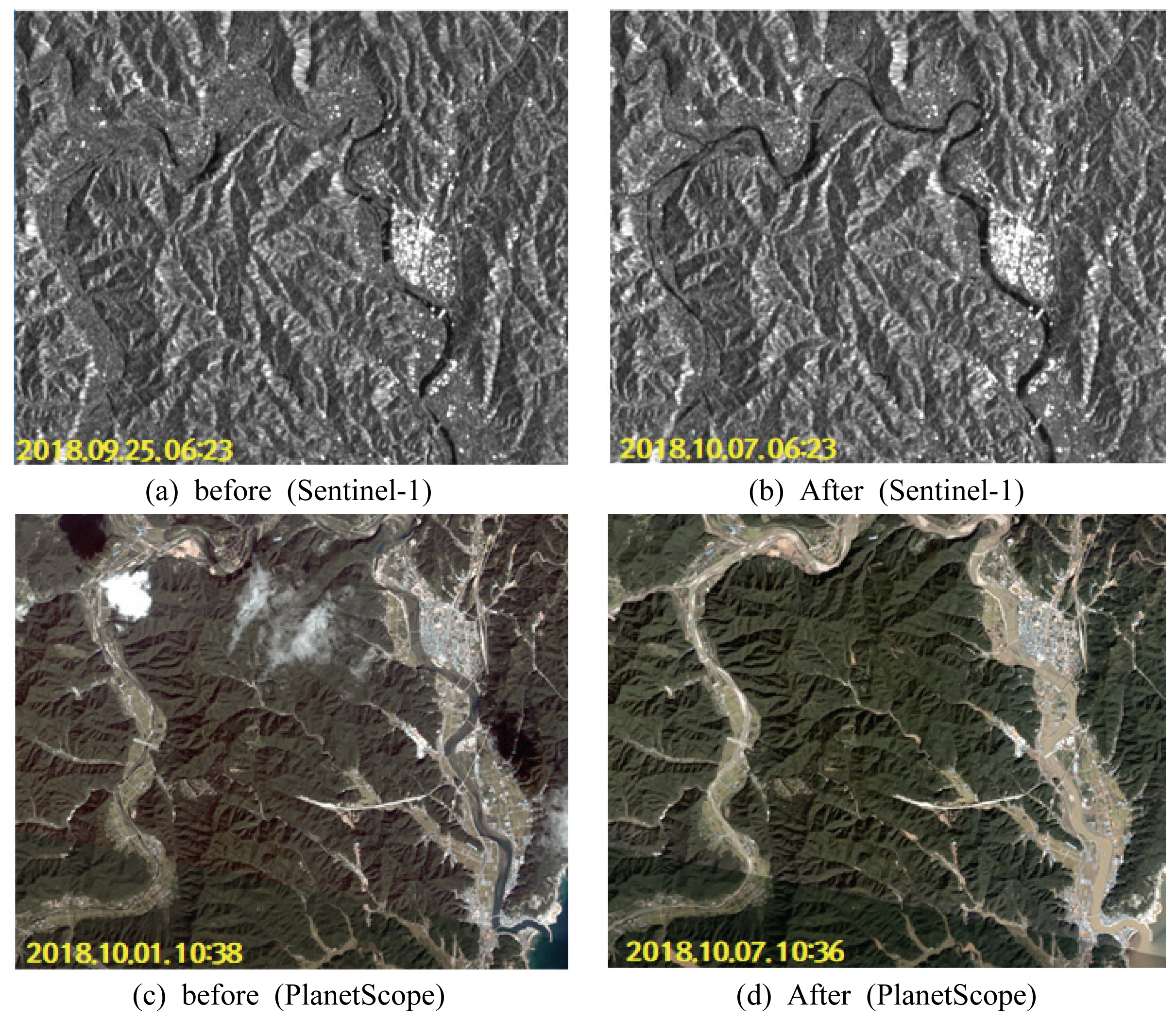
м№ЁмҲҳм¶”м •мқ„ мң„н•ҳм—¬ мң лҹҪ мҡ°мЈјкөӯ(European Space Agency, ESA)м—җм„ң м ңкіөн•ҳлҠ” л ҲмқҙлҚ”мң„м„ұ Sentinel-1кіј лҜёкөӯ Planet Labs Inc.м—җм„ң мҡҙмҡ© мӨ‘мқё кҙ‘н•ҷмң„м„ұ PlanetScopeлҘј нҷңмҡ©н•ҳмҳҖлӢӨ. Sentinel-1мқҖ C-band SARм„јм„ңлҘј нғ‘мһ¬н•ҳкі мһҲмңјл©°, мҙ¬мҳҒ м§Җм—ӯ л°Ҹ мЎ°кұҙм—җ л”°лқј 10 m лӮҙмҷёмқҳ кіөк°„н•ҙмғҒлҸ„лҘј к°Җм§Җкі мһҲкі , мҙ¬мҳҒмЈјкё°лҠ” 6мқј, мҙ¬мҳҒмқҳ лІ”мң„лҠ” 250 km лӮҙмҷёмқҙл©° нҺёкҙ‘мҙ¬мҳҒмқҙ к°ҖлҠҘн•ҳлӢӨ. PlanetScopeлҠ” R, G, B, NIR (near- infrared) мҙқ 4к°ңмқҳ л°ҙл“ңлЎң кө¬м„ұлҗҳм–ҙмһҲмңјл©°, кіөк°„н•ҙмғҒлҸ„лҠ” м•Ҫ 3 mмқҙлӢӨ. л¬ҙкІҢ 5 kg лҜёл§Ңмқҳ мһ‘мқҖ мң„м„ұмқ„ м•Ҫ 130м—¬к°ң л°ңмӮ¬н•ҳм—¬ м „ м§Җкө¬лҘј 1~3мқјмқҳ мҙ¬мҳҒмЈјкё°лЎң кҙҖмёЎн• мҲҳ мһҲмңјл©°, мҳҒмғҒ н•ң мһҘмқҳ мҙ¬мҳҒлІ”мң„лҠ” м•Ҫ 20 km Г— 12 kmмқҙлӢӨ. Sentinel-1 мң„м„ұмҳҒмғҒмқҖ мң„м„ұм—җм„ң л°ңмӮ¬лҗң C-band м „мһҗкё°нҢҢлҘј лҠҘлҸҷнҳ• м„јм„ңлЎң кҙҖмёЎн•ҳм—¬ м•…мІңнӣ„м—җ мғҒкҙҖм—Ҷмқҙ м§ҖмғҒмқҳ мғҒнҷ©мқ„ кҙҖмёЎн• мҲҳ мһҲлҠ” л°ҳл©ҙ лӢЁмқјл°ҙл“ңлЎң кҙҖмёЎлҗң нқ‘л°ұмҳҒмғҒмқҙл©°, PlanetScope мҳҒмғҒмқҖ 4к°ңмқҳ л°ҙл“ңлЎң лӢӨм–‘н•ң ліҖмҲҳмқҳ мёЎм •мқҙ к°ҖлҠҘн•ҳм§Җл§Ң кө¬лҰ„кіј к°ҷмқҙ лҢҖкё°мғҒмқҳ мһҘм• л¬јмқҙ мһҲлҠ” м§Җм—ӯмқҳ м§ҖмғҒмёЎм •мқҖ л¶Ҳк°ҖлҠҘн•ҳлӢӨлҠ” лӢЁм җмқҙ мһҲлӢӨ.
2.3 м№ЁмҲҳм§Җм—ӯ мӮ°м • л°©лІ•
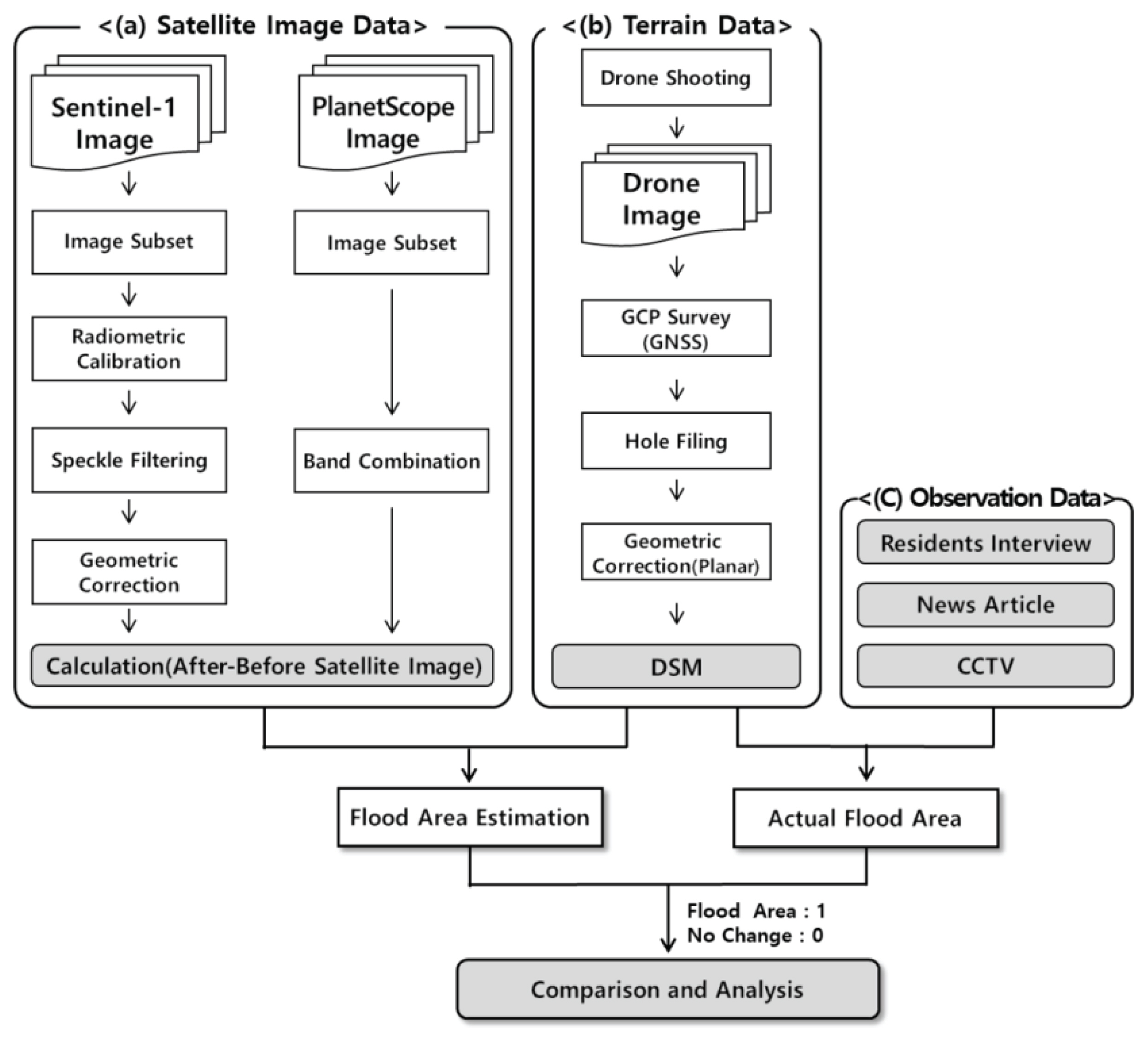
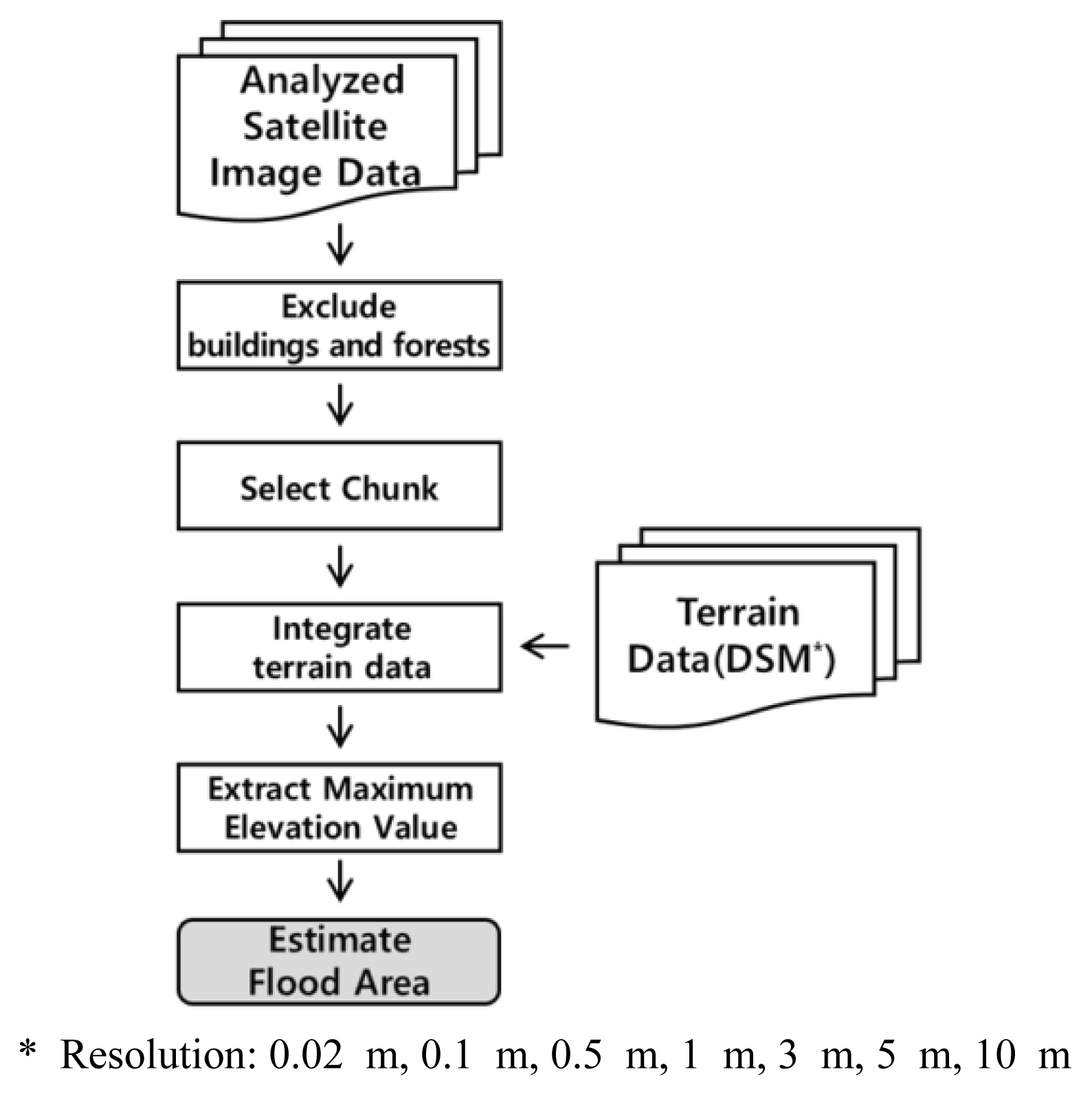
ліё м—°кө¬мқҳ мһҗлЈҢмІҳлҰ¬кіјм •мқҖ Fig. 3кіј к°ҷлӢӨ. нҒ¬кІҢ л ҲмқҙлҚ”мҳҒмғҒкіј кҙ‘н•ҷмң„м„ұмҳҒмғҒлі„ мһҗлЈҢмІҳлҰ¬, л“ңлЎ мқ„ нҶөн•ң м§Җнҳ•мһҗлЈҢмІҳлҰ¬ к·ёлҰ¬кі кҙҖмёЎ мһҗлЈҢм—җ л”°лҘё м •нҷ•м„ұ кІҖмҰқ кіјм •мңјлЎң кө¬м„ұлҗҳм–ҙмһҲлӢӨ.
2.3.1 мқёкіөмң„м„ұмқҳ мҳҒмғҒмІҳлҰ¬
Fig. 3(a)лҠ” мң„м„ұмҳҒмғҒлі„ мІҳлҰ¬кіјм •мқ„ ліҙм—¬мӨҖлӢӨ. кҙ‘н•ҷмң„м„ұмқё PlanetScopeмҷҖ лӢӨлҘҙкІҢ л ҲмқҙлҚ”мң„м„ұмқё Sentinel-1мқҖ нӣ„л°©мӮ°лһҖкі„мҲҳмқҳ к°’мңјлЎң мқҙлҜём§Җк°Җ кө¬м„ұлҗҳм–ҙмһҲкі мӮ°лһҖм—җ мқҳн•ң мҠӨнҺҳнҒҙ л…ёмқҙмҰҲ(Speckle Noise)к°Җ л¬ҙмһ‘мң„лЎң л°ңмғқн•ңлӢӨ. лҳҗн•ң, мёЎл©ҙмңјлЎң мҙ¬мҳҒмқҙ лҗҳкё° л•Ңл¬ём—җ мқҙлҘј ліҙм •н•ҳлҠ” м „мІҳлҰ¬ кіјм •мқҙ н•„мҡ”н•ҳлӢӨ(Brivio et al., 2002). мқҙ кіјм •мқҖ ESAм—җм„ң к°ңл°ңн•ң мң„м„ұмҳҒмғҒ 분м„қ н”„лЎңк·ёлһЁмқё(Sentinel Application Platform, SNAP)мқ„ нҷңмҡ©н•ҳм—¬ мІҳлҰ¬н•ҳмҳҖлӢӨ.
мҲҳ집н•ң мҙҲкё° мң„м„ұмҳҒмғҒмқҙлҜём§ҖлҠ” мҙ¬мҳҒлІ”мң„к°Җ л„“м–ҙ м„ёл¶ҖмҳҒм—ӯмқ„ м§Җм •н•ҳм—¬ 추м¶ңн•ҳлҠ” кіјм •мқ„ кұ°міӨлӢӨ. м •нҷ•лҸ„ кІҖмҰқмқ„ мң„н•ҳм—¬ мҲҳ집н•ң CCTVмҳҒмғҒ мЈјліҖм§Җм—ӯ 200 m Г— 200 mлЎң м„ м •н•ҳмҳҖлӢӨ. к·ё нӣ„, мҷңкіЎлҗң м „мһҗкё°нҢҢлҘј нӣ„л°©мӮ°лһҖ к°’мңјлЎң ліҙм •н•ҳлҠ” л°©мӮ¬ліҙм •кіјм •мқ„ 진н–үн•ҳкі , л…ёмқҙмҰҲлҘј л¶Җл“ңлҹҪкІҢ л°”кҫём–ҙмЈјлҠ” н•„н„°л§Ғмқ„ 진н–үн•ҳмҳҖлӢӨ. мӮ¬мҡ©н•ң н•„н„°лҠ” к°Җмҡ°мӢңм•Ҳ 분нҸ¬лҘј л”°лқј кҙҖмӢ¬мҳҒм—ӯм—җ мһҲлҠ” к°’мқ„ нҸүк· к°’мңјлЎң ліҖкІҪн•ҙмЈјлҠ” Lee sigma н•„н„°лЎң SNAP н”„лЎңк·ёлһЁмқҳ кё°ліё к°’мқё 7 Г— 7 мӮ¬мқҙмҰҲлҘј мӮ¬мҡ©н•ҳмҳҖлӢӨ(Lee, 1983; Lee et al., 2009). м—¬кё°м„ң м„ нғқн•ң нҺёкҙ‘мқҖ м№ЁмҲҳмҳҒм—ӯ кө¬л¶„м—җ нғҒмӣ”н•ң VHлҘј мӮ¬мҡ©н•ҳмҳҖлӢӨ(Ezzine et al., 2018).
л§Ҳм§Җл§үмңјлЎң мўҢн‘ңлҘј WGS84лЎң ліҖкІҪн•ҳкі м§Җнҳ•мқҳ кё°ліө л°Ҹ мёЎл©ҙмҙ¬мҳҒм—җ л”°лҘё мҷңкіЎмқ„ ліҙм •н•ҳлҠ” м§Җнҳ•ліҙм •мқ„ мҲҳн–үн•ҳмҳҖлӢӨ(Zeng et al., 2017).
PlanetScopeмқҳ кІҪмҡ°, Sentinel-1кіј л§Ҳм°¬к°Җм§ҖлЎң кҙҖмӢ¬мҳҒм—ӯм—җ лҢҖн•ҳм—¬ 추м¶ңн•ҳмҳҖкі , м§Җм—ӯм—җ лҢҖн•ҙ мһҗм—°мғү н•©м„ұ(R,G,B=Band3,2,1)мңјлЎң л°ҙл“ңлҘј мЎ°н•©н•ҳмҳҖлӢӨ.
л‘җ мң„м„ұмқҳ м „мІҳлҰ¬ кіјм •мқҙ лҒқлӮҳл©ҙ, к°Ғ мһ¬н•ҙ м „кіј нӣ„мқҳ м°ЁмқҙлҘј мӮ°м •н•ҳм—¬ ліҖнҷ”м§Җм—ӯмқ„ н‘ңм¶ңн• мҲҳ мһҲлӢӨ.
2.3.2 м§Җнҳ•мһҗлЈҢ мІҳлҰ¬
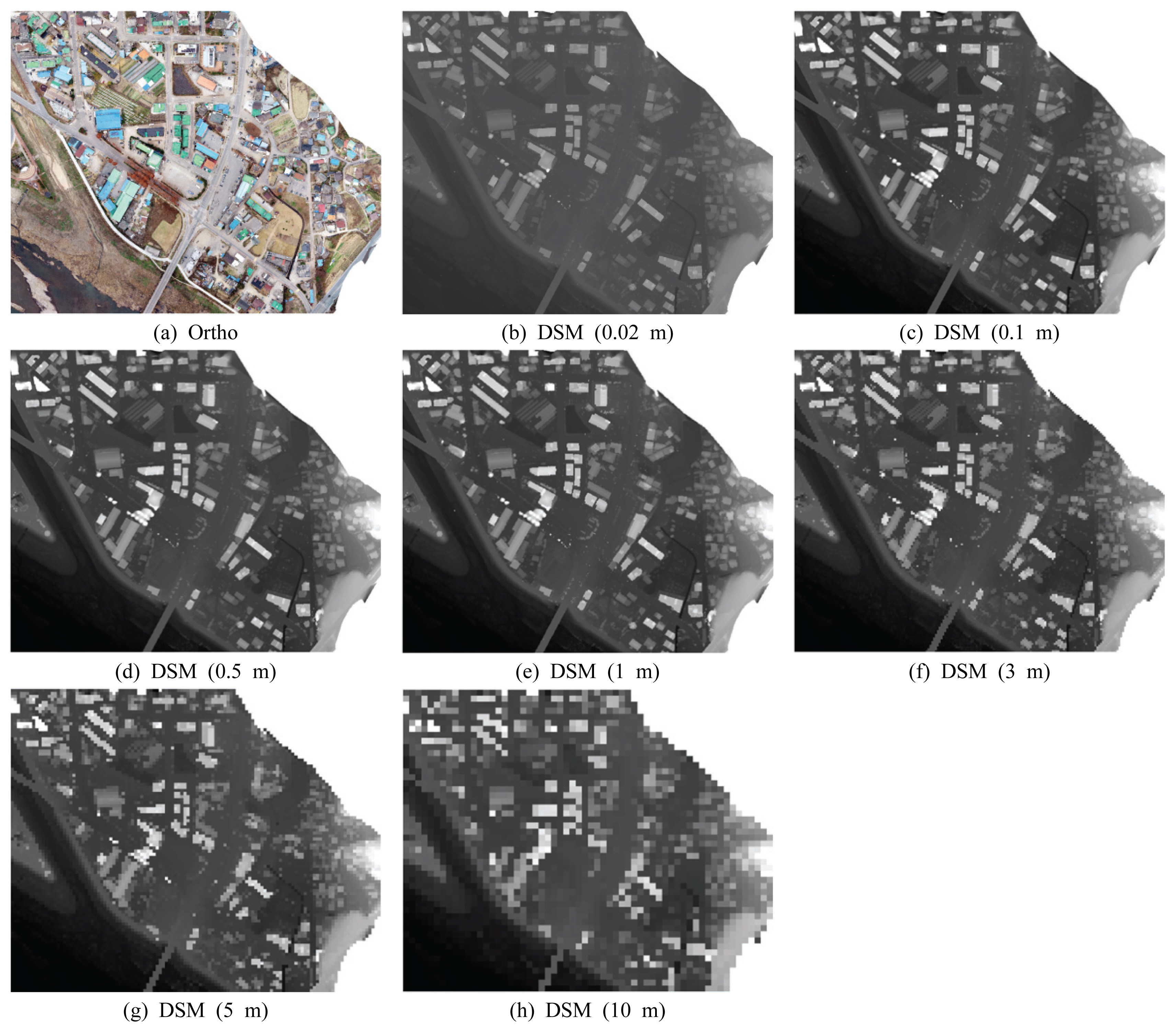
ліё м—°кө¬м—җм„ңлҠ” м§Җнҳ•мһҗлЈҢлЎң DSMмһҗлЈҢлҘј нҷңмҡ©н•ҳмҳҖлӢӨ. DSMмқҳ кІҪмҡ° л“ңлЎ мңјлЎң м§Ғм ‘ мҙ¬мҳҒн•ҳм—¬ мһҗлЈҢлҘј мғқм„ұн•ҳм—¬ 추к°Җліҙм •мқҙ н•„мҡ”н•ҳлӢӨ(Fig. 3(b)).
мҙ¬мҳҒм—җ нҷңмҡ©н•ң л“ңлЎ мқҖ мӨ‘көӯ DJIмқҳ Phantom 4 Pro V2.0мқҙл©°, лҜёкөӯ Bentleyмқҳ Context Capture(CC) н”„лЎңк·ёлһЁм—җ нғ‘мһ¬лҗң Photogrammetry кё°лҠҘмңјлЎң 3м°Ёмӣҗ м§Җнҳ•мһҗлЈҢлҘј мғқм„ұн•ҳмҳҖлӢӨ.
Phantom 4лҠ” н”Ҫм…ҖлӢ№ 2 cm м •лҸ„ н•ҙмғҒлҸ„лҘј к°Җм§Җл©°, л°°н„°лҰ¬ н•ҳлӮҳлӢ№ мөңлҢҖ 30분 м •лҸ„ 비н–үмқ„ н• мҲҳ мһҲлӢӨ.
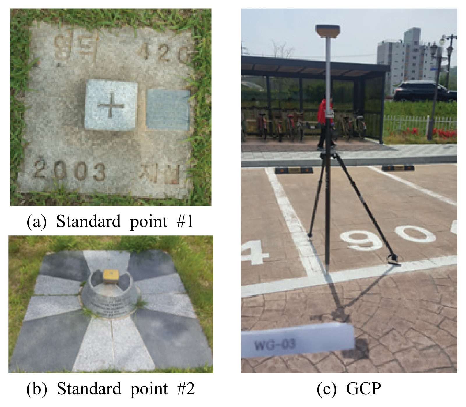
кё°мғҒмғҒнғңм—җ л§һ추м–ҙ мҙ¬мҳҒмқҳ мӨ‘мІ©лҸ„лҠ” 70~80%, мҙ¬мҳҒ лҶ’мқҙлҠ” 60~70 mлЎң м„Өм •н•ҳм—¬ CCTVмһҗлЈҢкё°мӨҖмңјлЎң мҳҒлҚ•мқҚкіј к°•кө¬л©ҙмқ„ мҙ¬мҳҒн•ҳм—¬ мҙқ 9,974мһҘмқҳ мһҗлЈҢлҘј мҲҳ집н•ҳмҳҖлӢӨ. мң„м„ұ нҸ¬м§Җм…”лӢқ мӢңмҠӨн…ңмқё Global Positioning System (GPS), GLObal NAvigation Satellite System (GLONASS)к°Җ л“ңлЎ м—җ лӮҙмһҘлҗҳм–ҙ мһҲм§Җл§Ң, мҳҒмғҒмқҳ мҷңкіЎм—җ л”°лҘё мң„м№ҳ ліҙм •мқ„ мң„н•ҙ Ground Control Point (GCP)лҘј Global Navigation Satellite System (GNSS)лЎң мёЎлҹүн•ҳм—¬м•ј н•ңлӢӨ. лҳҗн•ң, мҲҳмӨҖм җ 1к°ң, мӮјк°Ғм җ 1к°ң(Fig. 4(a)), нҶөн•©м җ 2к°ң(Fig. 4(b)), мҙқ 4к°ңмқҳ көӯк°Җкё°мӨҖм җмқ„ нҷңмҡ©н•ҳм—¬ GCP ліҙм •мқ„ н•ҳмҳҖлӢӨ. GCP м§Җм •мқҖ мЈјм°Ём„ л“ұкіј к°ҷмқҙ мң„м№ҳм •ліҙлҘј лҡңл ·н•ҳкІҢ нҷ•мқёмқҙ к°ҖлҠҘн•ң лӘЁм„ңлҰ¬ л¶Җ분мңјлЎң мҙқ 17к°ңлҘј м§Җм •н•ҳм—¬ мёЎлҹүн•ҳмҳҖлӢӨ(Fig. 4(c)).
CC н”„лЎңк·ёлһЁмқ„ нҶөн•ҙ л“ңлЎ мңјлЎң мҙ¬мҳҒн•ң мқҙлҜём§ҖлҘј л¶Ҳлҹ¬л“Өм—¬ GCP мўҢн‘ңлҘј м§Җм •н•ҳкі , н‘ңл©ҙ кө¬л©Қмқ„ л©”мҡ°лҠ” ліҙм •кіј м§Җнҳ•ліҙм •мқ„ кұ°м№ҳл©ҙ, 3DлӘЁлҚёл§Ғ, Ortho (Fig. 5(a)), н•ҙмғҒлҸ„лі„ Digital Surface Models (DSM; Figs. 5(b)~5(h))мһҗлЈҢмқҳ 추м¶ңмқ„ н• мҲҳ мһҲлӢӨ.
2.3.3 м§ҖмғҒ кҙҖмёЎмһҗлЈҢ мІҳлҰ¬
мң„м„ұмҳҒмғҒкё°л°ҳ м№ЁмҲҳм¶”м •к·ңлӘЁмқҳ м •нҷ•м„ұ кІҖмҰқмқ„ мң„н•ҳм—¬ кҙҖмёЎмһҗлЈҢлЎң мЈјлҜјл“Өмқҳ мқён„°л·°мҷҖ лүҙмҠӨкё°мӮ¬ к·ёлҰ¬кі CCTVмһҗлЈҢлҘј мҲҳ집н•ҳмҳҖлӢӨ(Fig. 3(c)). CCTVмһҗлЈҢлҠ” мҳҒлҚ•кІҪм°°м„ңм—җм„ң м ңкіөл°ӣм•ҳмңјл©°, CCTVмқҳ мҙ¬мҳҒлІ”мң„лҘј лІ—м–ҙлӮҳлҠ” м§Җм—ӯмқҳ м№ЁмҲҳм—¬л¶ҖлҠ” нғҗл¬ёмЎ°мӮ¬мҷҖ лүҙмҠӨкё°мӮ¬ мҲҳ집мқ„ нҶөн•ҙ нҢҗлӢЁн•ҳмҳҖлӢӨ.
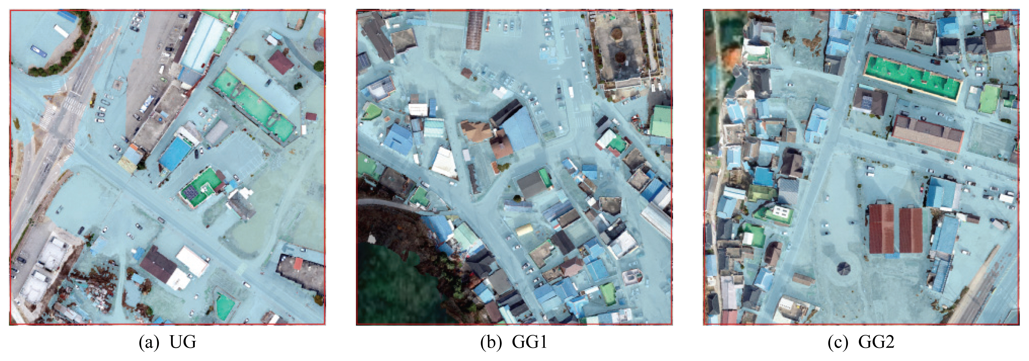
CCTVмһҗлЈҢлҠ” Fig. 6мқҳ мўҢмёЎкіј к°ҷмқҙ мҳҒлҚ•мқҚмқҳ мҡ°кіЎмӮ¬кұ°лҰ¬ мЈјліҖ(UG), к°•кө¬л©ҙмқҳ мҳӨнҸ¬лҰ¬ көҗнҡҢ мЈјліҖ(GG1) к·ёлҰ¬кі к°ҷмқҖ к°•кө¬л©ҙмқҳ мғҒлЎқмҲҳл№Ңлқј мЈјліҖ(GG2)мңјлЎң 3м§Җм—ӯмңјлЎң лӮҳлҲҢ мҲҳ мһҲмңјл©°, мҙқ 4к°ңмқҳ CCTVмҳҒмғҒмқ„ мҲҳ집н•ҳмҳҖлӢӨ.
мҲҳ집н•ң CCTVмҳҒмғҒмһҗлЈҢ мЈјліҖмқ„ 200 m Г— 200 m нҒ¬кё°лЎң м§Җм •н•ҳм—¬ Fig. 6 мҡ°мёЎкіј к°ҷмқҙ мӢңк°„м—җ л”°лҘё м№ЁмҲҳк·ңлӘЁлҘј нҷ•мқён•ҳм—¬ м№ЁмҲҳмқҳ мөңкі к·ңлӘЁм—җ н•ҙлӢ№н•ҳлҠ” лҒқм җмқ„ ArcGISнҲҙлЎң мҲҳлҸҷн‘ңмӢңн•ҳмҳҖлӢӨ. CCTVмҳҒмғҒмқ„ лІ—м–ҙлӮҳлҠ” м§Җм—ӯмқҳ кІҪмҡ° 0.02 m DSM м§Җнҳ•мһҗлЈҢмҷҖ н•©м„ұн•ҳм—¬ к°ҖмһҘ лҶ’мқҖ м№ЁмҲҳмӢ¬мқ„ кё°лЎқн•ң м§Җм җліҙлӢӨ лӮ®мқҖ лӘЁл“ м§Җм—ӯм—җ м№ЁмҲҳк°Җ л°ңмғқн•ҳмҳҖлӢӨкі к°Җм •н•ҳмҳҖлӢӨ. мқҙлҠ” нғҗл¬ёмЎ°мӮ¬мҷҖ лүҙмҠӨмһҗлЈҢлҘј нҶөн•ҙ нғҖлӢ№н•ҳлӢӨ нҢҗлӢЁн•ҳмҳҖмңјл©°, м •нҷ•н•ң м№ЁмҲҳм§Җм—ӯмқҳ нҷ•мқёмқҙ л¶Ҳк°ҖлҠҘн•ҳлҜҖлЎң мқҙлҘј м°ёк°’мңјлЎң к°Җм •н• мҲҳ мһҲлӢӨ.
CCTVкё°л°ҳмңјлЎң м№ЁмҲҳнқ”м Ғмқ„ м¶”м •н•ң мҳҒм—ӯмқ„ Ortho мқҙлҜём§Җм—җ кІ№міҗ н‘ңнҳ„н•ҳл©ҙ, Fig. 7кіј к°ҷлӢӨ. мқҙлҠ” кІҖмҰқкіјм •м—җм„ң м№ЁмҲҳлІ”мң„мқҳ м •нҷ•м„ұмқ„ нҸүк°Җн•ҳлҠ” мһҗлЈҢлЎң нҷңмҡ©н•ҳмҳҖлӢӨ.
2.3.4 м§Җнҳ•мһҗлЈҢмҷҖ мң„м„ұмҳҒмғҒмқ„ нҶөн•ң м№ЁмҲҳм§Җм—ӯ мӮ°м • л°Ҹ кІҖмҰқ
мң„м„ұмҳҒмғҒмқҳ мҙ¬мҳҒмӢңм җмқҙ мөңлҢҖ м№ЁмҲҳмӢңм җкіј мқјм№ҳн•ҳлҠ” кІғмқҖ м№ЁмҲҳм§Җм—ӯмқҳ мӢңкіөк°„м Ғ ліҖлҸҷм„ұкіј мң„м„ұмҳҒмғҒмқҳ к·ңм№ҷм Ғмқё мҙ¬мҳҒмЈјкё°лЎң мқён•ҳм—¬ л¶Ҳк°ҖлҠҘн•ҳлҜҖлЎң мң„м„ұмҳҒмғҒмһҗлЈҢлҘј 분м„қн•ҳм—¬ мӮ°м¶ңн•ң м№ЁмҲҳнқ”м Ғкіј м§Җнҳ•мһҗлЈҢлҘј лҸҷмӢңм—җ нҷңмҡ©н•ҳм—¬ м№ЁмҲҳм§Җм—ӯмқ„ нҢҗлі„н•ҳмҳҖлӢӨ.
Fig. 8мқҖ мң„м„ұмҳҒмғҒмһҗлЈҢмҷҖ м§Җнҳ•мһҗлЈҢлҘј нҶөн•ҙ м№ЁмҲҳм§Җм—ӯмқ„ м¶”м •н•ҳлҠ” л°©лІ•мқҳ к°ңл…җлҸ„мқҙл©°, Fig. 9лҠ” м„ёл¶Җкіјм •мқҳ нқҗлҰ„лҸ„мқҙлӢӨ. м№ЁмҲҳ м „кіј нӣ„ мң„м„ұмҳҒмғҒмқҳ м°Ёмқҙк°Җ нҒ° мҳҒм—ӯмқ„ 추м¶ңн•ҳл©ҙ, Fig. 8(a)мқҳ нҢҢлһҖмғү л¶Җ분과 к°ҷмқҙ лӮҳнғҖлӮј мҲҳ мһҲлӢӨ. мқҙ мҳҒм—ӯмқҖ мӮ°лҰјкіј кұҙл¬јмқ„ м ңмҷён•ң нҸүм§ҖлЎң Ortho мқҙлҜём§ҖлҘј м°ёкі н•ҳм—¬ 추м¶ңн•ҳмҳҖкі , лҸ„нҳ•нҷ”н•ҳм—¬ нҒ° лҚ©м–ҙлҰ¬л§Ң м„ лі„н•ҳмҳҖлӢӨ. мқҙлҘј м§Җнҳ•мһҗлЈҢмҷҖ 비көҗн•ҳм—¬ мөңлҢҖ м№ЁмҲҳм§Җм—ӯмқҳ кі лҸ„ліҙлӢӨ лӮ®мқҖ м§Җм—ӯмқ„ м№ЁмҲҳм§Җм—ӯмңјлЎң к°Җм •н•ҳмҳҖлӢӨ(Fig. 8(b) ліҙлқјмғү л¶Җ분). мқҙ кІ°кіјлҘј CCTVкё°мӨҖмңјлЎң мӮ°м •лҗң м№ЁмҲҳнқ”м Ғкіј 비көҗн•ҳм—¬ м •нҷ•м„ұ кІҖмҰқмқ„ 진н–үн•ҳмҳҖлӢӨ.
кІҖмҰқл°©лІ•мқҖ кіөк°„мқҳ мң„м№ҳм •нҷ•лҸ„лҘј мёЎм •н•ҳлҠ” Lee Sallee Shape Index (LSSI)лҘј нҷңмҡ©н•ҳмҳҖлӢӨ. CCTVкё°л°ҳмңјлЎң мӮ°м •н•ң м№ЁмҲҳлІ”мң„лҘј м°ёк°’мңјлЎң м •н•ҳмҳҖмңјл©°, мң„м„ұмҳҒмғҒмһҗлЈҢмҷҖ м§Җнҳ•мһҗлЈҢлҘј кё°л°ҳмңјлЎң мӮ°м •н•ң м№ЁмҲҳлІ”мң„лҘј м¶”м •к°’мңјлЎң м§Җм •н•ҳмҳҖлӢӨ.
Eq. (1)кіј к°ҷмқҙ м°ёк°’мқё AмҷҖ м¶”м •к°’мқё Bмқҳ көҗ집합м—җ л”°лҘё 합집합 비лЎң лӮҳнғҖлӮј мҲҳ мһҲлӢӨ. м—¬кё°м„ң LSSIлҠ” 0м—җм„ң 1мӮ¬мқҙ к°’мқ„ к°Җм§Җл©°, 1м—җ к°Җк№ҢмҡёмҲҳлЎқ м •нҷ•лҸ„к°Җ лҶ’кі 0м—җ к°Җк№ҢмҡёмҲҳлЎқ лӮ®лӢӨ(Lee and Sallee, 1970; Wentz, 1997; Jung et al., 2007; Lee et al., 2019).
3. м—°кө¬ кІ°кіј
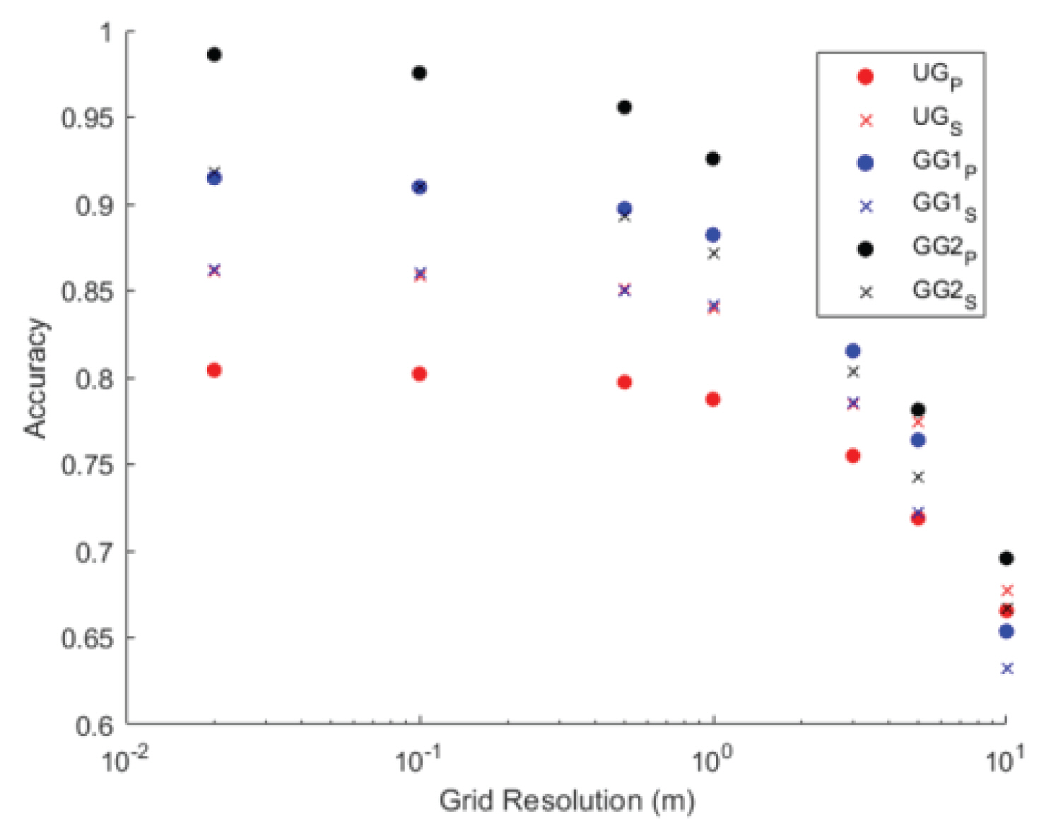
Fig. 10мқҖ мҳҒлҚ•мқҚ мҡ°кіЎмӮ¬кұ°лҰ¬ мЈјліҖ, к°•кө¬л©ҙ мҳӨнҸ¬лҰ¬ көҗнҡҢмЈјліҖ к·ёлҰ¬кі мғҒлЎқмҲҳл№Ңлқј мЈјліҖмқ„ Sentinel-1кіј PlanetScopeлЎң 분м„қн•ҳм—¬ LSSI л°©лІ•мңјлЎң м •нҷ•лҸ„лҘј мӮ°м •н•ң кІ°кіјмқҙлӢӨ. x축мқҖ м№ЁмҲҳм§Җм—ӯнҢҗлі„м—җ нҷңмҡ©н•ң DSMмқҳ н•ҙмғҒлҸ„лҘј лӮҳнғҖлӮёлӢӨ(Fig. 5 м°ёмЎ°).
3.1 мҳҒлҚ•мқҚ мҡ°кіЎмӮ¬кұ°лҰ¬ мЈјліҖ(UG)
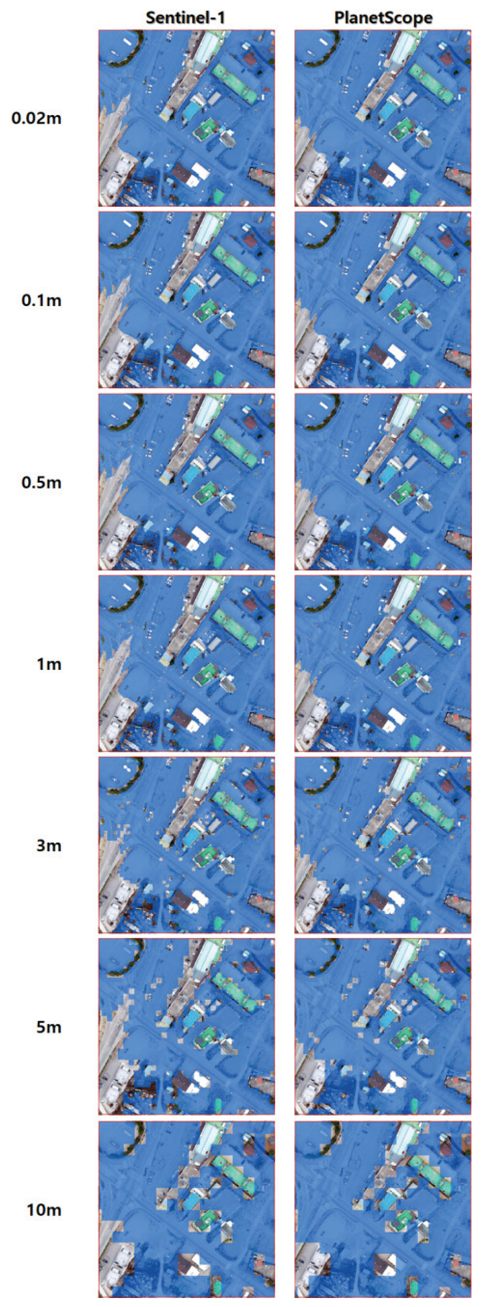
мҳҒлҚ•мқҚ мҡ°кіЎмӮ¬кұ°лҰ¬ мЈјліҖмқ„ мң„м„ұмҳҒмғҒкіј н•ҙмғҒлҸ„лі„ DSMмһҗлЈҢлЎң н•©м„ұн•ҳм—¬ м№ЁмҲҳк·ңлӘЁлҘј м¶”м •н•ң кІ°кіј, Sentinel-1мқҳ кІҪмҡ° CCTVкё°л°ҳмқҳ м№ЁмҲҳмҳҒм—ӯкіј мң мӮ¬н•ң м–‘мғҒмқ„ ліҙмқҙкі , PlanetScopeмқҳ кІҪмҡ° кіјлҢҖмӮ°м •лҗң кІғмқ„ нҷ•мқён• мҲҳ мһҲм—ҲлӢӨ(Appendix Fig. 12). мң„м„ұмҳҒмғҒмқҙ мҙ¬мҳҒлҗң мӢңм җмқҖ л°°мҲҳ нӣ„ 12мӢңк°„ м •лҸ„мқёлҚ°, мқҙ кё°к°„ лҸҷм•Ҳ м№ЁмҲҳлЎң мқён•ҙ мһ кІјлҚҳ м§Җм—ӯмқҙ лӢӨлҘё м§Җм—ӯмңјлЎң нқҳлҹ¬лӮҙлҰ¬л©° нқҷнғ•л¬јмқҳ нқ”м ҒмңјлЎң лӮЁкІҢ лҗҳм–ҙ к°ҖмӢңкҙ‘м„ мңјлЎң мҙ¬мҳҒлҗң кҙ‘н•ҷмң„м„ұмқҖ кіјлҢҖмӮ°м •мқҙ лҗң кІғмңјлЎң ліҙмқёлӢӨ. н•ҳм§Җл§Ң л ҲмқҙлҚ”мң„м„ұмқҳ кІҪмҡ° м§Җл©ҙмқҳ л ҲмқҙлҚ” нӣ„л°©мӮ°лһҖкі„мҲҳк°’мқ„ нҷңмҡ©н•ҳм—¬ н‘ңм¶ңлҗҳлҜҖлЎң к°ҖмӢңкҙ‘м„ м—җ мғҒкҙҖм—Ҷмқҙ м –мқҖ м§Җм—ӯмқҳ нқ”м Ғ 추м¶ңн•ҳкІҢ лҗҳм–ҙ м •нҷ•м„ұмқҙ лҶ’кІҢ мёЎм •лҗң кІғмңјлЎң м¶”м •лҗңлӢӨ(Fig. 11). м§Җнҳ•мһҗлЈҢмқҳ кІҪмҡ° н•ҙмғҒлҸ„к°Җ лӮ®м•„м§ҲмҲҳлЎқ кұҙл¬ј л“ұмқҳ мқёкіөкө¬мЎ°л¬јкіј мӮ°лҰјм§Җм—ӯмқҳ кІ©мһҗк°Җ м»Өм§ҖлҜҖлЎң м •нҷ•лҸ„к°Җ 60% м •лҸ„лЎң л–Ём–ҙм§ҖлҠ” кІғмқ„ нҷ•мқён• мҲҳ мһҲлӢӨ.
3.2 к°•кө¬л©ҙ мҳӨнҸ¬лҰ¬ көҗнҡҢ мЈјліҖ(GG1)
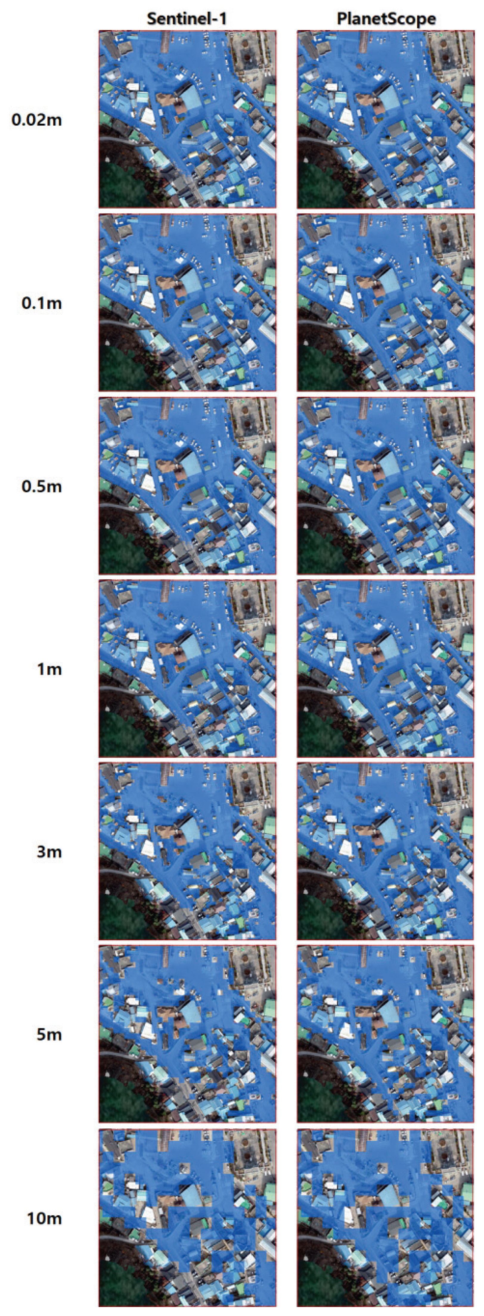
к°•кө¬л©ҙ мҳӨнҸ¬лҰ¬ көҗнҡҢ мЈјліҖмқ„ мң„м„ұмҳҒмғҒкіј н•ҙмғҒлҸ„лі„ DSMмһҗлЈҢлЎң н•©м„ұн•ҳм—¬ м№ЁмҲҳк·ңлӘЁлҘј м¶”м •н•ң кІ°кіј, л‘җ мң„м„ұ лӘЁл‘җ 0.02 mм—җм„ң 1 m м§Җнҳ•мһҗлЈҢк№Ңм§Җ 80% мқҙмғҒмқҳ м •нҷ•лҸ„лҘј ліҙмҳҖмңјл©°, мҳҒлҚ•мқҚ мҡ°кіЎмӮ¬кұ°лҰ¬ мЈјліҖмқҳ кІ°кіјмҷҖ лӢӨлҘҙкІҢ PlanetScopeлЎң 분м„қн•ң м№ЁмҲҳм¶”м • м§Җм—ӯмқҙ Sentinel-1ліҙлӢӨ м •нҷ•лҸ„к°Җ лҶ’мқҖ кІғмңјлЎң нҷ•мқён•ҳмҳҖлӢӨ(Appendix Fig. 13). нҸүм§Җмқё мҳҒлҚ•мқҚ лҢҖмғҒм§Җ(UG)мҷҖ лӢ¬лҰ¬ мӮ°м§Җк°Җ 분нҸ¬лҗҳм–ҙ мһҲкі мЈјліҖм§Җм—ӯ м „мІҙк°Җ 1 m мқҙмғҒ м№ЁмҲҳлҗҳм—Ҳкё° л•Ңл¬ём—җ мҙ¬мҳҒмӢңм җм—җ кҙҖкі„м—Ҷмқҙ лҶ’мқҖ м •нҷ•лҸ„лҘј ліҙмқҙлҠ” кІғмңјлЎң нҢҗлӢЁн•ңлӢӨ. лҳҗн•ң, л ҲмқҙлҚ”мң„м„ұмқё Sentinel-1мқҳ кІҪмҡ° лӮҳл¬ҙмҷҖ мқёкіөкө¬мЎ°л¬јмқҳ к·ёлҰјмһҗм—җ лҢҖн•ң л°ҳмӮ¬ к°’м—җ мҳҒн–Ҙмқҙ мһҲм–ҙ кұҙл¬јмқҙ л°Җ집лҗң к°•кө¬л©ҙм§Җм—ӯмқҙ мҳҒлҚ•мқҚліҙлӢӨ м •нҷ•лҸ„к°Җ лӮ®мқҖ кІғмңјлЎң м¶”м •н•ңлӢӨ(Table 3). DSMмқҳ кІ©мһҗк°Җ м»Өм§ҲмҲҳлЎқ мқёкіөкө¬мЎ°л¬јмқҳ мҳҒн–Ҙмқҙ нҒ¬лҜҖлЎң кұҙл¬јл°Җ집лҸ„к°Җ мғҒлҢҖм ҒмңјлЎң м ҒмқҖ мҳҒлҚ•мқҚмқҳ лҢҖмғҒм§Җ(UG)ліҙлӢӨ м •нҷ•лҸ„к°Җ лӮ®м•„м§ҖлҠ” кІғмқ„ нҷ•мқён• мҲҳ мһҲлӢӨ.
3.3 к°•кө¬л©ҙ мғҒлЎқмҲҳл№Ңлқј мЈјліҖ(GG2)
к°•кө¬л©ҙ мғҒлЎқмҲҳл№Ңлқј мЈјліҖмқ„ мң„м„ұмҳҒмғҒкіј н•ҙмғҒлҸ„лі„ DSMмһҗлЈҢлЎң н•©м„ұн•ҳм—¬ м№ЁмҲҳк·ңлӘЁлҘј м¶”м •н•ң кІ°кіј, лӢӨлҘё л‘җ лҢҖмғҒм§Җм—җ 비н•ҙ 3 m м§Җнҳ•мһҗлЈҢк№Ңм§Җ 80% мқҙмғҒмқҳ м •нҷ•лҸ„лҘј ліҙмҳҖмңјл©°, лӢӨлҘё к°•кө¬л©ҙ лҢҖмғҒм§Җ(GG1)мқҳ кІ°кіјмҷҖ мң мӮ¬н•ҳкІҢ PlanetScopeмңјлЎң 분м„қн•ң м№ЁмҲҳм¶”м •м§Җм—ӯмқҙ Sentinel-1ліҙлӢӨ м •нҷ•лҸ„к°Җ лҶ’мқҖ кІғмңјлЎң нҷ•мқён•ҳмҳҖлӢӨ(Appendix Fig. 14). мқҙ м§Җм—ӯлҸ„ GG1кіј к°ҷмқҙ мЈјліҖ м „мІҙк°Җ 1m мқҙмғҒ м№ЁмҲҳк°Җ лҗң кіімқҙл©°, мң„м„ұмҳҒмғҒмңјлЎң кҙҖм°°н• л•Ң к°ҖмһҘ нҡЁкіјм ҒмңјлЎң 분м„қн• мҲҳ мһҲм—ҲлӢӨ. лҳҗн•ң, кұҙл¬јл°ҖлҸ„к°Җ лӢӨлҘё лҢҖмғҒм§ҖліҙлӢӨ лҶ’м•„(Table 3), Sentinel-1ліҙлӢӨ кҙ‘н•ҷмң„м„ұмқё PlanetScopeмқҳ м •нҷ•лҸ„к°Җ лҶ’мқҖ кІғмңјлЎң ліҙмқёлӢӨ. н•ңнҺё, лӢӨлҘё м§Җм—ӯкіј мң мӮ¬н•ҳкІҢ кІ©мһҗк°Җ м»Өм§ҲмҲҳлЎқ м •нҷ•лҸ„к°Җ л–Ём–ҙм§ҖлҠ” м–‘мғҒмқ„ ліҙмқҙлӮҳ лӢӨлҘё к°•кө¬л©ҙмқҳ лҢҖмғҒм§Җ(GG1)ліҙлӢӨ мӮ°м§Җк°Җ м ҒкІҢ 분нҸ¬н•ҳм—¬ м •нҷ•лҸ„к°Җ ліҙлӢӨ лҶ’кІҢ мёЎм •лҗң кІғмқ„ нҷ•мқён• мҲҳ мһҲлӢӨ.
4. кІ° лЎ
ліё м—°кө¬м—җм„ңлҠ” мқёкіөмң„м„ұкіј м§Җнҳ•м •ліҙлҘј лҸҷмӢңм—җ нҷңмҡ©н•ҳм—¬ м№ЁмҲҳлІ”мң„лҘј мӮ°м •н•ҳмҳҖкі , мқҙлҘј м§ҖмғҒкҙҖмёЎмһҗлЈҢмҷҖ 비көҗ분м„қмқ„ нҶөн•ҙ м •нҷ•м„ұмқ„ кІҖмҰқмқ„ н•ҳм—¬ м№ЁмҲҳнқ”м ҒлҸ„ мһ‘м„ұмӢң мң„м„ұмҳҒмғҒмқҳ нҷңмҡ© к°ҖлҠҘм„ұмқ„ нҷ•мқён•ҳмҳҖлӢӨ. м—°кө¬лҢҖмғҒм§ҖлЎңлҠ” 2018л…„ 10мӣ”мҙҲ л°ңмғқн•ң нғңн’Қ мҪ©л Ҳмқҙ(KONG-REY)м—җ мқҳн•ҙ н”јн•ҙлҘј мһ…мқҖ кІҪл¶Ғ мҳҒлҚ•кө°мқҳ мҳҒлҚ•мқҚкіј к°•кө¬л©ҙ м§Җм—ӯмқҙл©°, мң„м„ұмҳҒмғҒмһҗлЈҢлҠ” ESAмқҳ Sentinel-1 н•©м„ұк°ңкө¬л ҲмқҙлҚ”(SAR)мһҗлЈҢмҷҖ PlanetLabмқҳ PlanetScope кҙ‘н•ҷмҳҒмғҒмқ„ нҷңмҡ©н•ҳмҳҖлӢӨ. кІҖмҰқм—җ нҷңмҡ©н•ң м§ҖмғҒкҙҖмёЎмһҗлЈҢлҠ” кҙҖн• кІҪм°°м„ңм—җм„ң CCTVлҘј м ңкіөл°ӣм•„ нҷңмҡ©н•ҳмҳҖкі , м§Җнҳ•мһҗлЈҢлҠ” л“ңлЎ мҙ¬мҳҒмһҗлЈҢлЎң кө¬м¶•н•ң н•ҙмғҒлҸ„лі„(0.02 m, 0.1 m, 0.5 m, 1 m, 3 m, 5 m, 10 m) DSM мһҗлЈҢ нҷңмҡ©н•ҳмҳҖлӢӨ. 분м„қ кІ°кіј лӢӨмқҢкіј к°ҷмқҖ кІ°лЎ мқ„ м–»м—ҲлӢӨ.
(1) м§Җнҳ•мһҗлЈҢмқҳ кіөк°„н•ҙмғҒлҸ„к°Җ лҶ’мқ„мҲҳлЎқ лҶ’мқҖ м •нҷ•лҸ„лЎң м№ЁмҲҳм§Җм—ӯмқ„ нҢҗлі„н• мҲҳ мһҲлӢӨ.
(2) нҸүм§Җмқҳ кІҪмҡ°, л ҲмқҙлҚ”мң„м„ұмқҳ кІ°кіјк°Җ мӢӨм ңмһҗлЈҢмҷҖ мң мӮ¬н•ҳкІҢ м№ЁмҲҳк·ңлӘЁлҘј нҢҗлі„н• мҲҳ мһҲлӢӨ.
(3) мқёкіөкө¬мЎ°л¬јмқҙ л°Җ집лҗҳм–ҙмһҲлҠ” кІҪмҡ°, кҙ‘н•ҷмң„м„ұмңјлЎң мҙ¬мҳҒлҗң мҳҒмғҒмқ„ нҷңмҡ©н•ҳлҠ” кІғмқҙ мӢӨм ң м№ЁмҲҳм§Җм—ӯкіј мң мӮ¬н•ҳкІҢ нҢҗлі„н• мҲҳ мһҲлӢӨ.
ліё м—°кө¬лҠ” м№ЁмҲҳлІ”мң„мқҳ м°ёк°’мқ„ м–»лҠ”лҚ° нҷңмҡ©лҗң CCTV мһҗлЈҢк°Җ м ңн•ңлҗң м§Җм—ӯм—җл§Ң м„Өм№ҳлҗҳм–ҙ мһҲм–ҙ м—°кө¬м§Җм—ӯ м „мІҙм—җ лҢҖн•ң м№ЁмҲҳлІ”мң„лҘј мӮ°м •н•ҳм§ҖлҠ” лӘ»н•ҳмҳҖлӢӨ. мқҙлЎң мқён•ң н•ңкі„лҠ” лҢҖмғҒм§Җм—ӯм—җ лҢҖн•ҳм—¬ 2м°Ёмӣҗ мҲҳлҰ¬лӘЁнҳ•мқ„ кө¬м¶•н•ҳкі мқҙлҘј CCTV мһҗлЈҢлЎң көҗм •н•ҳм—¬ м№ЁмҲҳлІ”мң„мқҳ м°ёк°’мқ„ м–»лҠ” л°©лІ•мқ„ нҶөн•ҙ к·№ліөн• мҲҳ мһҲмқ„ кІғмқҙлӢӨ. лҳҗн•ң, ліё м—°кө¬лҘј нҶөн•ҙ мІЁлӢЁмҳҒмғҒмқ„ нҷңмҡ©н•ң м№ЁмҲҳнқ”м ҒлҸ„ мһ‘м„ұмқҖ кё°мЎҙліҙлӢӨ мӢ мҶҚн•ҳкі кҙ‘лІ”мң„н•ҳкІҢ мһҗлЈҢлҘј мҲҳм§‘н• мҲҳ мһҲмқ„ кІғмңјлЎң кё°лҢҖн•ҙліёлӢӨ.