Comparative Radial Analysis of Philippines’ Local Flood Vulnerability Index
Article information
Abstract
Flood has been a primary concern and one of the global issues today, because it has been knocking down lives, economy, live stocks which people has been striving to protect. In the Philippines, flood is also a big issue and although there is an existing flood vulnerability index (FVI) assessment, vulnerable areas are not accurately identified because it is done on a larger scale basis. In this research an FVI under a smaller scale was used to assess the vulnerability of five areas (one city and four municipalities) in the province of Albay, Philippines. A comparative analysis was also performed to identify which among these five areas are more vulnerable to flooding. Analytical Hierarchy Process (AHP) was used to weigh the indicators and components through the expert decision from surveys made by different professionals. A 10-year data from 2006 to 2015 was collected wherein the first 5 years was used for calibration and the succeeding years was for verification. The outcome is standardized with values ranging from 0 to 1 (extremely low, low, moderate, high and extremely high).
Finally, assessment of each components (social, economic, environmental and physical) showed that all five areas are identified to be extremely high vulnerable for both environmental and physical components. While for the social and economic component, the value ranges from moderate to high vulnerability. Manito has the highest overall FVI with a value of 0.655, followed by Guinobatan, Bacacay, Camalig and lastly, Legazpi with values of 0.632, 0.576, 0.521 and 0.509, respectively. Therefore, application of FVI assessment to smaller scale areas provides specific results in identifying the areas which are vulnerable to flooding.
Trans Abstract
오늘날 인명피해, 경제손실, 가축피해 등을 야기하는 홍수는 국제적 관심사이며, 피해를 저감시키기 위해 꾸준히 노력하고 있다. 또한, 필리핀에서도 홍수는 주요 관심사이며, 홍수취약성 분석을 위해 홍수취약도지수(FVI)분석 방법을 사용하여 취약성분석을 수행하고 있다. 그러나 광범위한 지역에 대해 FVI 분석을 수행하기 때문에 홍수취약지역이 정밀하게 분석되지 않고 있다. 본 연구에서는 소규모 지역에 FVI 방법을 적용하기 위하여 필리핀 Albay지방 다섯 개 지역(1개 도시와 4개 지방지치구)에 대해 취약성을 분석하고, 비교하였다. FVI분석의 요소와 지표를 평가하기 위해 전문가 대상의 설문을 이용한 방법인 AHP 방법을 사용하였다. 과거 10년(2006~2015) 동안의 홍수피해 자료를 수집하여 처음 5개년 자료는 보정, 나머지 5개년 자료는 검증을 위해 사용하였으며, 이를 통해 0에서 1의 범위로 홍수취약성을 표준화하여 ‘매우 낮음’, ‘낮음’, ‘보통’, ‘높음’, ‘매우 높음’으로 구분하였다.
각 구성요소(사회적, 경제적, 환경적, 물리적)에 대한 분석결과, 5개 지역 모두 환경적 요소 및 물리적 요소에 대한 취약성은 ‘매우 높음’으로 평가되었으며, 사회적 요소 및 경제적 요소에 대한 취약성은 ‘보통’에서 ‘높음’으로 평가되었다. 종합적인 FVI 분석결과 Manito 지역의 취약성이 0.632로 홍수에 가장 취약한 것으로 평가 되었으며, Guinobatan, Bacacay, Camalig, Legazpi 지역에서 각각 0.632, 0.576, 0.521, 0.509로 분석되었다. 위의 결과를 통해 소규모 지역에 FVI평가를 진행함으로서 구체적인 홍수취약성 분석이 가능한 것으로 확인되었다.
1. Introduction
Climate change increases the frequencies and intensities of disasters. They are becoming more and more visible and have greatly been considered by humanity as a problem that needs to be addressed. Many researchers linked the increase in intensities and frequencies of these disasters to climate change, which has been a global issue since the 19th century (Harley et al., 2008; Hinkel, 2011; Balica et al., 2012; Ezra, 2016). One disaster, flood, is now considered a pressing concern because it is one of the major causes of destructions to the world. How to reduce or mitigate its adverse effects is the primary focus of every country’s government and communities. According to S. F. Balica, Douben, & Wright (2009) and Stefania Balica, & Wright (2010), Flood Vulnerability Index (FVI) is an indicator-based methodology, which is established for the purpose of decreasing flood threats everywhere that also involves two concepts: vulnerability and resilience and assess the conditions, which influence flood damage at various spatial scales to distinguish the different characteristics at each identified spatial scale allowing a more in-depth analysis and interpretation of local indicators.
The objective of this study is to use a local flood vulnerability index (FVI) to portray the level of vulnerability an area has by means of indicators to gauge flood. Moreover, use the result in a comparative radial approach, to understand and visualize which among the components and index values of each area has depicted a high vulnerability to flood. In order to do so, the formation of equations of the overall FVI and the four components namely social, economic, environmental and physical along with its weight considerations using a pair-wise comparison method from the Analytic Hierarchy Process (AHP) was done. The assessment and evaluation is applied to four municipalities and a city, so that the localities can focus on what component of vulnerability they are the weakest, in order to create policies and make a correct decision on how to mitigate and handle flood. The advantage and importance of this type of research is that it is more specific due to it being in a smaller scale. Also, this type of scale is recommended by previous researchers (Adger et al., 2004; Balica, 2007; Vincent, 2007; Cutter et al., 2008; Sebald, 2010; Yoon, 2012) to make a detailed and specified vulnerability assessment and usage once the index is established. According to related literature, mitigating communities’ vulnerability is the utmost responsibility of the LGUs’ (Warren, 2013; Adger et al., 2004; Cutter et al., 2010). The difference of this study with other related studies is the use of the lower scale (local) which makes it more defined and specific. Also, this research is the very first research conducted in the Philippines under a small scale, so this can be used or would serve as a guide for future researchers who are willing to establish and improved this type of scale. If the execution of countermeasures towards disasters such as flood be made effective by the community and the government, then there would be a better chance to withstand and be more flexible to such disasters making the recovery period much faster (Adger, 2006; Adger et al., 2004; Cutter et al., 2008).
Table 1 show the list of indicators which were used in this study. These indicators would serve as the final indicators that were consolidated and arranged in a manner approved by the local experts of the province due to data availability and easement in data collection.
Indicators Per Factor and Component
2. Methods
This section shows the study area and gives the detailed process on how to arrive at the comparative analysis that the researchers were aiming to achieve at the beginning. There are several steps in accomplishing this study.
Table 2 show a brief background as of 2015 of the five areas assessed in this research and also Fig. 1 shows the municipalities and city used by the researchers in the application of the said study. These areas would be assessed and compared as to which among them would depict low or high flood vulnerability. In the table it illustrates the population, area and, the number of villages that are under each city and municipality which would give a brief summary and initial assumptions from the researchers whether or not the area or population (if higher or larger) would affect the behavior of flood vulnerability in the final results.
Descriptive Summary of the Study Areas

Chosen Study Areas for Albay, Philippines
In order to arrive at the desired results, the following steps were made. First is the collection of related literatures regarding flood vulnerability index (FVI) under a local scale which was made by referring to several journals, books, conference proceedings, as well as previous thesis and dissertations. After which the indicators to be used were selected. For this second step, process of deduction and elimination was made wherein all the indicators with almost same description and meaning were combined and also, those which are not suited for the local scale and the aim of this study were not considered. Today, there are thousands of indicators used in different fields, so minimizing and controlling the use of indicators is needed to make a robust research. In Table 3, the number of indicators per component and factor is shown and are also based on the data availability in the study areas. This was also agreed upon by the local experts in the area from fields of engineering, disaster management and risk reduction, academe, government offices and agencies as well. The experts that participated in this survey were asked based on their judgment as to what type of indicators can be used in the said research. Also, if the four components having the list of detailed indicators stated in Table 2 would suffice.

Number of Indicators Used
The next step is to put weights on each indicator and components and decide which among them are of utmost importance. Analytical Hierarchy Process (AHP) was used in this study to determine the weights which involves a pair- wise comparison matrix in assessing the scores given by the experts from a scale of 1-9. Table 4 illustrates how to score base on the significance and this was made by Saaty (1980), in order to allocate the weights of each criterion. Precise estimation of the pertinent data based on decision- making is one of the decisive steps, for it is very tricky to quantify them correctly. Therefore, attempts to validate the relative importance of each criterion or substitute were done by many decision-making methods.

Relative Importance Scale (according to Saaty, 1980)
Psychological experiments have also proven that individuals cannot concurrently compare more than seven objects (plus or minus two) (Miller, 1956). This is the reason why Saaty made 9 as the upper limit of his scale and 1 as the lower limit and a unit difference between successive scale values. Additionally, basing on this scale, the existing values for the pair-wise comparison are members of the set: {9, 8, 7, 6, 5, 4, 3, 2, 1, ½, 1/3, ¼, 1/5, 1/6, 1/7, 1/8, 1/9}.
After the weights have been identified, gathering the data from a span of 10 years from 2006-2015 was done in order to apply the developed FVI. The first 5 years is used for calibration and the next 5 years would be used for verification. Once the calibration and verification is completed, the index values of each component as well as the overall FVI values of each area would be identified. Thus, as the final step, a comparative radial analysis can be made using excel to identify the relationship and condition of each area. This would also distinguish which among the areas would give high vulnerability in terms of flood so that government and the people can help adapt and reduce these vulnerabilities. Table 5 shows the category and the range on how to identify whether an area is low or extremely high in flood vulnerability.
Explanation of the Designated FVI Values
3. Results and Discussion
The result of this study shows how vulnerable an area is in terms of flood and under which component has it portrayed a high value. In Fig. 2, it illustrates the assessment of the component’s FVI values under each area. It is very noticeable that both the environmental and physical has incurred the highest values for all the areas. These two components should be given the utmost priority by the local government units in order to abate flood vulnerability. Certain structural counter- measures should be implemented and careful planning must be done to avoid excessive spending of the government from projects which will not reduce vulnerability to floods. Additionally, both the social and economic components must not be placed or set aside for these two also gave a high value and since these two deals with the economy, welfare and lives of the people, unquestionably, this must not be neglected and must be monitored as well.
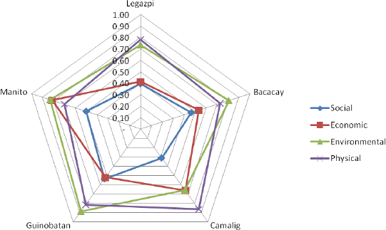
Components FVI Results Per Area
Finally, for the results of the overall FVI values seen in Fig. 3, through the comparative analysis, it can be noted that the municipality of Manito has the highest value of 0.655 followed by Guinobatan with 0.632, then Bacacay with 0.576, next is Camalig with 0.521 and the last is the city of Legazpi with 0.509. Based from the outcome, all have shown a “Highly Vulnerable to Flood” status when checked with Table 5 for the scale criterion. It would be wise to believe that since the previous years, vulnerability to flood was not yet further reduced or mitigated. Even the capital city of the province showed a lofty value which is very alarming. This type of analysis in research is believed to be of stronger and contains more relevant information when shared for it shows new and current results in the field of water resources. Therefore, re-assessing and re- evaluating the strategies and plans as well as the measures being done by the government is needed to adapt and lessen the effects of flood events in the local areas.
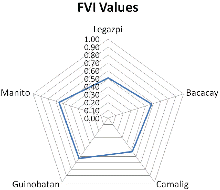
Comparative Radial Analyses of 5 Local Areas
4. Conclusion
The results of the study have proven that in the local areas where flood vulnerability index was evaluated and applied, the areas were all affected and subjected with high vulnerabilities to flood. It found out that Manito gave the highest overall FVI value and the city of Legazpi has the lowest. It is good to note that these areas are entities of their own and does not represent the bigger or larger scale. However, if flood vulnerability was reduced under these local areas then there may be a possibility that on a national or country level scaling, it may have a positive effect on abating such vulnerability.
Acknowledgments
This research was supported by a grant (13SCIPS04) from Smart Civil Infrastructure Research Program funded by Ministry of Land, Infrastructure and Transport (MOLIT) of Korea government and Korea Agency for Infrastructure Technology Advancement (KAIA).