


1. ņä£ļĪĀ
ņÜ░ļ”¼ļéśļØ╝ ļÅÖĒĢ┤ņĢłņØä ļ╣äļĪ»ĒĢśņŚ¼ ņäĖĻ│ä ņŚ¼ļ¤¼ ņ¦ĆņŚŁņŚÉņä£ ņŚ░ņĢł ņ╣©ņŗØņŚÉ ņØśĒĢ£ Ēö╝ĒĢ┤Ļ░Ć ļ╣łļ▓łĒĢ┤ ņ¦ĆĻ│Ā ņ׳ļŗż. ņØ┤ļ¤¼ĒĢ£ ņŚ░ņĢł ņ╣©ņŗØņØĆ ĒĢ┤ņĢł ļÅäļĪ£ ĒīīņåÉņØä ļ╣äļĪ»ĒĢśņŚ¼ ĒĢ┤ņłśņÜĢņן ļ¬©ļל ņ£Āņŗż ļō▒ņØś ņé¼ĒÜī Ļ▓ĮņĀ£ņĀü ņØĖ ņåÉņŗżņØä Ļ░ĆņĀĖņśżĻ│Ā ņ׳ņ£╝ļ®░, ļö░ļØ╝ņä£ ņØ┤ļ¤¼ĒĢ£ ņŚ░ņĢł ņ╣©ņŗØņŚÉ ļīĆĒĢśņŚ¼ ņĀüņĀłĒĢśĻ▓ī ļīĆņØæĒĢśņ¦Ć ļ¬╗ĒĢ£ļŗżļ®┤ ĻĘĖ Ēö╝ĒĢ┤ļŖö ņĀÉņ░© ņ”ØĻ░ĆĒĢĀ Ļ▓āņ£╝ļĪ£ ņśłņāüļÉśĻ│Ā ņ׳ļŗż. Ēśäņ×¼ ņŚ░ņĢłņ╣©ņŗØ ļ░®ņ¦Ćļź╝ ņ£äĒĢśņŚ¼ ņ╣©ņŗØņØś ņøÉņØĖņØä ĻĘ£ļ¬ģĒĢśļŖö ĒĢ£ĒÄĖ Ļ│ĄĒĢÖņĀü ļīĆņØæ ļ░Å ļ│ĄĻĄ¼ ļ░®ļ▓ĢņŚÉ Ļ┤ĆĒĢ£ ņŚ░ĻĄ¼Ļ░Ć ĒÖ£ļ░£ĒĢśĻ▓ī ņłśĒ¢ēļÉśĻ│Ā ņ׳ļŗż. ņŚ░ņĢł ņ╣©ņŗØĻ│╝ Ļ┤ĆļĀ©ļÉ£ Ļ┤æļ▓öņ£äĒĢ£ ņŚ░ĻĄ¼ ņżæ ņØ┤ ņŚ░ĻĄ¼ņŚÉņä£ļŖö Ēā£ĒÆŹĻ│╝ Ļ░ÖņØ┤ ņŻ╝ņÜöĒĢ£ ņŚ░ņĢł ņ╣©ņŗØ ņøÉņØĖņØ┤ ņ×æņÜ® ĒĢśĻĖ░ ņĀäĒøäņØś ĒĢ┤ņĢłņ¦ĆĒśĢņØś ļ│ĆĒÖöļź╝ ņŻ╝ĻĖ░ņĀüņØĖ ņłśņŗ¼ ņĖĪļ¤ēņØä ĒåĄĒĢśņŚ¼ ļ¬©ļŗłĒä░ļ¦üĒĢśĻĖ░ ņ£äĒĢ£ ĻĖ░ņ┤łņŚ░ĻĄ¼ļź╝ ņłśĒ¢ēĒĢśņśĆļŗż.
ņØ╝ļ░śņĀüņ£╝ļĪ£ ĒĢ┤ņ¢æņŚÉņä£ņØś ņłśņŗ¼ ņĖĪļ¤ēņØĆ ņåīĒśĢ ļśÉļŖö ņżæļīĆĒśĢ ņäĀļ░Ģ ĒĢśļČĆņŚÉ ņØīĒ¢źņĖĪņŗ¼ĻĖ░(echo sounder) ļō▒ņØś ņןņ╣śļź╝ Ēāæņ×¼ĒĢśņŚ¼ ņłśņŗ¼ņØä ņĖĪļ¤ēĒĢśļŖö Ļ▓āņØ┤ ņØ╝ļ░śņĀüņØ┤ņ¦Ćļ¦ī ĒĢ┤ņłśņÜĢņןņØä ļ╣äļĪ»ĒĢśņŚ¼ ņŚ░ņĢłņ╣© ņŗØņŚÉ ņØśĒĢ£ ĒĢ┤ņĀĆņ¦ĆĒśĢ ļ│ĆĒÖöĻ░Ć ņŗ¼Ļ░üĒĢ£ ņłśņŗ¼ņØ┤ ņłś ļ»ĖĒä░(m) ņØ┤ļé┤ņØś ņ▓£ĒĢ┤ņŚŁņŚÉņä£ļŖö ņäĀļ░ĢņØś ĒØśņłśņÖĆ ĒĢ©Ļ╗ś ņØīĒ¢źņĖĪņŗ¼ĻĖ░ ņäżņ╣śņŚÉ ĒĢäņÜöĒĢ£ ļåÆņØ┤ļĪ£ ņØĖĒĢśņŚ¼ ņØīĒ¢źņĖĪņŗ¼ĻĖ░ļź╝ ņØ┤ņÜ®ĒĢ£ ņłśņŗ¼ ņĖĪļ¤ēņØ┤ ļ¦żņÜ░ ņ¢┤ļĀĄĻ▒░ļéś ļČłĻ░ĆļŖźĒĢśļŗż. ļö░ļØ╝ņä£ ņØĖļĀźņŚÉ ņØśĒĢśņŚ¼ ņłśņŗ¼ņØä ņĖĪņĀĢĒĢśĻ▒░ļéś ļ¦ÄņØĆ ņłśņØś ņłśņ£äĻ│äļź╝ ņäżņ╣śĒĢśņŚ¼ ņłśņŗ¼ņØä ņĖĪļ¤ēĒĢĀ ņłś ņ׳ļŖöļŹ░, ņØ┤ņÖĆ Ļ░ÖņØĆ Ļ▓ĮņÜ░ ņŗ£Ļ░äĻ│╝ ņØĖļĀźņØ┤ ļ¦ÄņØ┤ ņåīņÜöļÉśņ¢┤ ļ╣äĻ▓ĮņĀ£ņĀüņØ╝ ļ┐Éļ¦ī ņĢäļŗłļØ╝ ņŚ░ņåŹ ņĖĪļ¤ēņØ┤ ņ¢┤ļĀżņÜ┤ ļŗ©ņĀÉņØ┤ ņ׳ļŗż. ļö░ļØ╝ņä£ ņĄ£ĻĘ╝ņŚÉļŖö ņ£äņä▒ ņśüņāü ļśÉļŖö ĒĢŁĻ│Ąņé¼ņ¦äņØä ņØ┤ņÜ®ĒĢśņŚ¼ ļ╣äĻĄÉņĀü ļäōņØĆ ņśüņŚŁņŚÉ ļīĆĒĢ£ ņłśņŗ¼ņĖĪļ¤ēņØä ĒÜ©ņ£©ņĀüņ£╝ļĪ£ ĒĢĀ ņłś ņ׳ļŖö ļ░®ļ▓ĢņŚÉ ļīĆĒĢ£ ņŚ░ĻĄ¼Ļ░Ć Ļ┤Ćņŗ¼ņØä ļ░øĻ│Ā ņ׳ļŗż.
ļ│Ė ņŚ░ĻĄ¼ņŚÉņä£ ļŗżļŻ©Ļ│Ā ņ׳ļŖö ņ▓£ĒĢ┤ņŚŁņŚÉņä£ņØś ņśüņāü ĻĖ░ļ░śņØś ņłśņŗ¼ ņĖĪļ¤ēĻ│╝ Ļ┤ĆļĀ©ĒĢśņŚ¼ ĻĖ░ņĪ┤ņŚÉļŖö ņ£äņä▒ņ×ÉļŻīļź╝ ņØ┤ņÜ®ĒĢ£ ņé¼ļĪĆĻ░Ć ļ¦ÄņØ┤ ļ│┤Ļ│ĀļÉśĻ│Ā ņ׳ļŗż. ņ£äņä▒ņé¼ņ¦äņØä ņØ┤ņÜ®ĒĢ£ ņŚ░ĻĄ¼ņŚÉņä£ļŖö ļ¼╝ņØś Ēł¼Ļ│╝ņ£©ņØ┤ ļåÆņØĆ Landsat TMņØś ņ×ÉļŻīļź╝ ņØ┤ņÜ®ĒĢśņŚ¼ ņŚ░ņĢłņ¦ĆņŚŁņŚÉņä£ņØś ņłśņŗ¼ņØä ņĖĪļ¤ēĒĢ£ ļ░ö ņ׳Ļ│Ā(van Hengel and Spitzer, 1991; Gholamalifard et al., 2013), Lyzenga(1985), Paredes and Spero(1983), Spitzer and Dirk(19687) ļō▒ņØĆ ņ£äņä▒ņ×ÉļŻīļź╝ ņØ┤ņÜ®ĒĢśņŚ¼ ņŚ░ņĢłņ¦ĆņŚŁņŚÉņä£ņØś ņłśņŗ¼ņØä Ļ░äņĀæņĀüņ£╝ļĪ£ ņĖĪļ¤ēĒĢśĻ│Āņ×É ĒĢśļŖö ņŚ░ĻĄ¼ļź╝ ņłśĒ¢ēĒĢ£ ļ░ö ņ׳ļŗż. ĻĄŁļé┤ņŚÉņä£ļÅä ņ£äņä▒ņśüņāüņØä ņØ┤ņÜ®ĒĢ£ ņŚ░ņĢłņ¦ĆņŚŁņØś ņłśņŗ¼ņĖĪļ¤ēņŚÉ Ļ┤ĆĒĢ£ ņŚ░ĻĄ¼ļź╝ ņłśĒ¢ēĒĢ£ ļ░ö ņ׳ņ£╝ļéś ļŗ╣ņŗ£ ņłśņŗ¼ņĖĪļ¤ē ļīĆņāü ņ¦ĆņŚŁņØ┤ Ļ░»ļ▓ī ņ¦ĆņŚŁņØĖ ņśüņé░Ļ░Ģ ĒĢśĻĄ¼ ņ¦ĆņŚŁņ£╝ļĪ£ ļ¼╝ņØ┤ ļ¦żņÜ░ Ēś╝ĒāüĒĢśņŚ¼ ņśüņāüņ×ÉļŻīņÖĆ ņłś ņŗ¼ ņé¼ņØ┤ņØś ņāüĻ┤ĆĻ┤ĆĻ│äĻ░Ć ļåÆņ¦Ć ņĢŖņĢśļŗż(Lee, 1999). ĻĘĖļ¤¼ļéś ņØ┤ ņŚ░ĻĄ¼ņŚÉņä£ ņĀ£ņŗ£ĒĢ£ ņŻ╝ņä▒ļČä ļČäņäØ(PCA, Principal Component Analysis) ņØä ļ╣äļĪ»ĒĢ£ ļ░®ļ▓ĢļōżņØĆ ņśüņāüņ×ÉļŻīļź╝ ņØ┤ņÜ®ĒĢśņŚ¼ ņłśņŗ¼ņØä ņĖĪļ¤ēĒĢśļŖöļŹ░ ņ׳ņ¢┤ ņóŗņØĆ ļ░®ļ▓ĢņØä ņĀ£ņŗ£ĒĢ£ Ļ▓āņ£╝ļĪ£ ĻĘĖ ņØśļ»Ėļź╝ ĒÅēĻ░ĆĒĢĀ ņłś ņ׳ļŗż.
ĒĢ£ĒÄĖ, ĒĢŁĻ│Ąņé¼ņ¦äņØä ņØ┤ņÜ®ĒĢ£ ĻĖ░ņĪ┤ ņŚ░ĻĄ¼ļŖö ņ£ĀņåŹņØś ņśüĒ¢źņØ┤ ņØīĒ¢ź ņĖĪņŗ¼ĻĖ░ ļō▒ņØä Ēāæņ×¼ĒĢ£ ņäĀļ░ĢņØä ņÜ┤ņśüĒĢśĻĖ░ ņ¢┤ļĀżņÜ┤ ĒĢśņ▓£ņØä ļīĆņāüņ£╝ļĪ£ ļ¦ÄņØ┤ ņłśĒ¢ēļÉśĻ│Ā ņ׳ļŗż(Flener et al., 2012; Fonstad and Marcus, 2005; Jordan and Fonstad, 2005; Legleiter, 2013, 2015; Walther et al., 2011; Zinke and Flener, 2013). Fonstad and Marcus(2005)ļŖö ņłśļ”¼ĒĢÖņĀü ņøÉļ”¼ļź╝ ņśüņāüņ▓śļ”¼ ĻĖ░ņłĀĻ│╝ ņĀæļ¬®ĒĢśņŚ¼ HAB(Hydraulically Assisted Bathymetry) ļ░®ļ▓ĢņØä ņĀ£ņĢł ĒĢ£ ļ░ö ņ׳ļŗż. ņØ┤ļōżņØĆ ņśüņāüņ▓śļ”¼ņŚÉ ņØśĒĢśņŚ¼ ņłśņŗ¼ņØä ņĖĪļ¤ēĒĢĀ ļĢī ļ│┤ ņĀĢĒĢĀ ņłś ņ׳ļŖö Ļ│äņłśļź╝ ņ¦üņĀæ ņĖĪļ¤ēĒĢ£ ņłśņŗ¼ņ×ÉļŻīļź╝ ņØ┤ņÜ®ĒĢśņ¦Ć ņĢŖĻ│Ā, ĒĢśņ▓£ņØś ņØ╝ņĀĢ ņ¦ĆņĀÉņŚÉņä£ ņ£Āļ¤ēĻ│╝ Ļ▓Įņé¼ ļō▒ņØś ņ×ÉļŻīļź╝ ņØ┤ņÜ®ĒĢ©ņ£╝ļĪ£ ņŹ© Ļ│äņłśļź╝ Ļ░äņĀæņĀüņ£╝ļĪ£ ĻĄ¼ĒĢĀ ņłś ņ׳ļÅäļĪØ ĒĢśĻ│Ā, ņØ┤ļź╝ Brazos RiverņÖĆ Lamar RiverņŚÉņä£ ņĀüņÜ®ĒĢ£ ļ░ö ņ׳ļŗż. ņØ┤ļōżņØś Ļ▓░Ļ│╝ļź╝ ļ│┤ ļ®┤ ĒĢśņ▓£ņŚÉ ļö░ļØ╝ ņ¦üņĀæ ņĖĪļ¤ēĒĢ£ ņłśņŗ¼Ļ│╝ ĒĢŁĻ│Ąņé¼ņ¦äņØä ņØ┤ņÜ®ĒĢśņŚ¼ ĻĄ¼ ĒĢ£ ņłśņŗ¼ ņé¼ņØ┤ņØś ņāüĻ┤ĆĻ│äņłś(R2)ļŖö 0.76 ņĀĢļÅäļĪ£ ļČäņäØļÉ£ ļ░ö ņ׳ļŗż.
ĒĢŁĻ│Ąņé¼ņ¦äņØä ņØ┤ņÜ®ĒĢ£ ņ▓£ĒĢ┤ņŚŁņŚÉņä£ņØś ņłśņŗ¼ņĖĪļ¤ēņØĆ ĒĢśņ▓£ņŚÉ ļ╣äĒĢ┤ņä£ļŖö ĻĘĖ ņŚ░ĻĄ¼Ļ░Ć ļ¦żņÜ░ ņĀ£ĒĢ£ņĀüņØ┤ļ®░ ņ┤łĻĖ░ņĀüņØĖ ļŗ©Ļ│äļØ╝ ĒĢĀ ņłś ņ׳ņ£╝ļ®░, ĻĄŁļé┤ņŚÉņä£ļÅä ņØ┤ļ¤¼ĒĢ£ ļ░®ļ▓ĢņØś Ļ░ĆļŖźņä▒ņØ┤ ļ░£Ēæ£ļÉ£ ļ░ö ņ׳ņ£╝ļéś (Ahn et al., 2016), ņ£äņä▒ņśüņāüņØä ņØ┤ņÜ®ĒĢ£ ņŚ░ĻĄ¼ņŚÉ ļ╣äĒĢ┤ņä£ļŖö ļ¦żņÜ░ ņĀ£ĒĢ£ņĀüņØ┤ļŗż. ĒĢŁĻ│Ąņé¼ņ¦äņØä ņØ┤ņÜ®ĒĢ£ ņ▓£ĒĢ┤ņŚŁņŚÉņä£ņØś ņłśņŗ¼ ņĖĪļ¤ēņØĆ ņŻ╝ļĪ£ ņ£äņä▒ņŚÉņä£ ņ┤¼ņśüĒĢśļŖö Hyperspectral ļśÉļŖö Multispectral ņ×ÉļŻīņŚÉ ļ╣äĒĢśņŚ¼ ņØ┤ņÜ® Ļ░ĆļŖźĒĢ£ ņŻ╝Ēīīņłś ļ▓öņ£äĻ░Ć Ļ░Ćņŗ£Ļ┤æņäĀņŚÉ ĒĢ£ņĀĢļÉśņ¢┤ ņ׳ņ£╝ļ®░, ĒŖ╣Ē׳ ņĀüņāē, ļģ╣ņāē, ņ▓Łņāēņ£╝ļĪ£ ņĀ£ĒĢ£ļÉśņ¢┤ ņ׳ņ¢┤ ņŚ¼ļ¤¼ ņŻ╝Ēīī ņłś ļ▓öņ£äļź╝ Ļ░¢ļŖö Ēīīļź╝ ņĖĪņĀĢĒĢĀ ņłś ņ׳ļŖö ņןļ╣äņŚÉ ļ╣äĒĢśņŚ¼ Ļ░ĆņÜ® ņ×ÉļŻīĻ░Ć ņĀ£ĒĢ£ņĀüņØ┤ļØ╝ ĒĢĀ ņłś ņ׳Ļ│Ā, ļśÉĒĢ£ ņØ┤ļ¤¼ĒĢ£ ņśüņāüņØś Ļ▓ĮņÜ░ ņłśņŗ¼ 15 m ņØ┤ņāüņØĖ Ļ▓ĮņÜ░ ļ╣øņØ┤ ļ¬©ļæÉ ĒØĪņłśļÉśņ¢┤ ņĀüņÜ®ņØ┤ ņ¢┤ļĀżņÜĖ ņłś ņ׳ļŗż (Lyzenga, 1979). ĻĘĖļ¤¼ļéś ņØ┤ļ¤¼ĒĢ£ ņśüņāüņןļ╣äļŖö ņāüļīĆņĀüņ£╝ļĪ£ ņĀĆĻ░ĆņØ┤ļ®░, ņØ┤ļ»Ė ļ¦ÄņØĆ ļööņ¦ĆĒäĖ ņ╣┤ļ®öļØ╝Ļ░Ć ļ│┤ĻĖēļÉśņ¢┤ ņ׳ļŗżļŖö ņĖĪļ®┤ņŚÉņä£ ņĀüņÜ®ņŚÉ ņ£Āļ”¼ĒĢśĻ│Ā, ļśÉĒĢ£ ņØ┤ ņŚ░ĻĄ¼ņŚÉņä£ ļŗżļŻ©Ļ│Āņ×É ĒĢśļŖö ĒĢ┤ņŚŁņØĆ ņ▓£ĒĢ┤ņŚŁņ£╝ļĪ£ ņØ┤ļ¤¼ĒĢ£ ļŗ©ņĀÉņØś ņśüĒ¢źņØä ņĄ£ņåīĒÖö ĒĢĀ ņłś ņ׳ņØä Ļ▓āņ£╝ļĪ£ ĒīÉļŗ©ĒĢśņśĆļŗż.
ņĄ£ĻĘ╝ņŚÉļŖö ņåīĒśĢ ļööņ¦ĆĒäĖ ņ╣┤ļ®öļØ╝ļź╝ ļō£ļĪĀ ļō▒ ļ¼┤ņØĖĻĖ░(UAV, Unmanned Aerial Vehicle)ņŚÉ Ēāæņ×¼ĒĢśņŚ¼ ņØ┤ļź╝ ņØ┤ņÜ®ĒĢ£ ņĀĆĻ│ĀļÅä ņ┤¼ņśüņØ┤ Ļ░ĆļŖźĒĢ┤ ņ¦ÉņŚÉ ļö░ļØ╝ Ļ│ĀĒĢ┤ņāüļÅä ņśüņāüņĀĢļ│┤ ņĘ©ļōØņØ┤ ņÜ®ņØ┤ĒĢ┤ ņ¦ĆĻ│Ā ņ׳ļŗż. Zinke and Flener(2013)ļŖö ļō£ļĪĀņØä ņØ┤ņÜ®ĒĢśņŚ¼ ĒĢŁĻ│Ą ņé¼ņ¦äņØä ņ┤¼ņśüĒĢśĻ│Ā ņØ┤ļĪ£ļČĆĒä░ ņłśņŗ¼ņØä ņĖĪņĀĢĒĢśĻĖ░ ņ£äĒĢ£ ņŚ░ĻĄ¼ļź╝ ņłś Ē¢ēĒĢ£ ļ░ö ņ׳ļŗż. ņĢäļלņØś Table 1ņØĆ ĻĖ░ņĪ┤ņØś ņØīĒ¢źņĖĪņŗ¼ĻĖ░ņŚÉ ņØśĒĢ£ ņłśņŗ¼ ņĖĪļ¤ēĻ│╝ ļō£ļĪĀ ļō▒ņØä ĒÖ£ņÜ®ĒĢ£ ĒĢŁĻ│Ąņé¼ņ¦ä ĻĖ░ļ░śņØś ņłśņŗ¼ ņĖĪļ¤ē ļ░®ļ▓ĢņØä Ļ░äļץĒ׳ ļ╣äĻĄÉĒĢ£ ļé┤ņÜ®ņØ┤ļŗż.
Table┬Ā1
Comparison between bathymetry survey methods
ņØ┤ ņŚ░ĻĄ¼ņŚÉņä£ļŖö ņŚ░ņĢłņ╣©ņŗØ Ļ│╝ņĀĢ ļČäņäØĻ│╝ Ļ┤ĆļĀ©ĒĢśņŚ¼ ņŚ░ņĢłņ╣©ņŗØņØ┤ ļ░£ņāØĒĢśļŖö ņ▓£ĒĢ┤ņŚŁņŚÉņä£ņØś ņłśņŗ¼ ļ│ĆĒÖöļź╝ ļ╣äĻĄÉņĀü ņēĮĻ▓ī ĻĄ¼ĒĢĀ ņłś ņ׳ļÅäļĪØ ļööņ¦ĆĒäĖ ņ╣┤ļ®öļØ╝ļź╝ Ēāæņ×¼ĒĢ£ ļō£ļĪĀņØä ņØ┤ņÜ®ĒĢśņŚ¼ ĒĢŁĻ│Ąņé¼ņ¦äņØä ņ┤¼ņśüĒĢśĻ│Ā, ņśüņāüņ×ÉļŻīņØś ļ░ØĻĖ░ņĀĢļ│┤ļź╝ ņØ┤ņÜ®ĒĢśņŚ¼ ņłśņŗ¼ņØä ņĖĪļ¤ēĒĢĀ ņłś ņ׳ļŖö ņśüņāü ĻĖ░ļ░śņØś ĻĖ░ļ▓ĢņØä ņĀ£ņĢłĒĢśņśĆļŗż. ĒĢ┤ņĢłņ╣©ņŗØņØ┤ ņÜ░ļĀżļÉśļŖö ļÅÖĒĢ┤ņĢłņØś ĒøäņĀĢĒĢ┤ņłśņÜĢņןņØä ļīĆņāüņ£╝ļĪ£ ļō£ļĪĀņ£╝ļĪ£ ņśüņāüņØä ņĘ©ļōØĒĢ£ Ēøä Ļ░äņĀæņĀüņ£╝ļĪ£ ņłśņŗ¼ņØä ņĖĪļ¤ēĒĢ£ Ēøä, ĻĘĖ Ļ▓░Ļ│╝ļź╝ ņØīĒ¢źņĖĪņŗ¼ĻĖ░ļĪ£ ņĖĪ ņĀĢĒĢ£ ņłśņŗ¼Ļ│╝ ļ╣äĻĄÉĒĢ©ņ£╝ļĪ£ņŹ© ņĀ£ņĢłļ░®ļ▓ĢņØś ņĀüņÜ®ņä▒ņØä ĒÅēĻ░ĆĒĢśņśĆļŗż.
2. ņØ┤ļĪĀņĀü ļ░░Ļ▓Į
2.1 ņśüņāüņ×ÉļŻīļź╝ ņØ┤ņÜ®ĒĢ£ ņłśņŗ¼ ņĖĪļ¤ēņØś ĻĖ░ļ│Ė
ĒĢŁĻ│Ą ļśÉļŖö ņØĖĻ│Ąņ£äņä▒ ļō▒ņŚÉņä£ ņ┤¼ņśüĒĢ£ ņśüņāüņ×ÉļŻīļŖö ņŚ░ņĢłņ¦ĆņŚŁņØś ņłśņŗ¼ ņĖĪļ¤ēņŚÉ ņ£ĀņÜ®ĒĢśĻ▓ī ņé¼ņÜ®ļÉĀ ņłś ņ׳ļŗż. Ļ░Ćņŗ£Ļ┤æņäĀņØä ļ╣äļĪ»ĒĢśņŚ¼ ņĀüņÖĖņäĀ, ņ×ÉņÖĖņäĀ ļō▒ņØä ĒżĒĢ©ĒĢ£ Ēā£ņ¢æĻ┤æņØ┤ ĒĢ┤ņłśļ®┤ ņĢäļלļĪ£ Ēł¼Ļ│╝ļÉĀ ļĢī Ļ░ü ĒīīņןļīĆņØś ĒŖ╣ņä▒ņŚÉ ļö░ļØ╝ ļ░śņé¼ļÉśļŖö ņĀĢļÅäĻ░Ć ļŗżļź┤ļ®░, ļö░ļØ╝ņä£ ļŗżņ¢æĒĢ£ ĒīīņןņØś ņ×ÉļŻīļź╝ ņØ┤ņÜ®ĒĢśļ®┤ ļ│┤ļŗż ņĀĢĒÖĢĒĢ£ ņłśņŗ¼ ņĖĪļ¤ēņØ┤ Ļ░ĆļŖźĒĢĀ Ļ▓āņØ┤ļŗż. ĻĘĖļ¤¼ļéś ņĀüņāē, ļģ╣ņāē, ņ▓Łņāēņ£╝ļĪ£ ļČäļ”¼ļÉśļŖö ļööņ¦ĆĒäĖ ņśüņāüņ×ÉļŻīļź╝ ņØ┤ņÜ®ĒĢśļ®┤ ņĀĢļ│┤ņØś ļ▓öņ£äĻ░Ć ņĀ£ĒĢ£ņĀüņØ┤ĻĖ░ļŖö ĒĢśļéś, ļ│┤ļŗż Ļ░äĒÄĖĒĢśĻ▓ī ņłśņŗ¼ņØä ņĖĪļ¤ēĒĢśļŖö Ļ▓āņØ┤ Ļ░ĆļŖźĒĢśļŗż. ņłśņŗ¼ņŚÉ ļö░ļØ╝ ļ╣øņØ┤ ĒØĪņłśļÉśļŖö ņĀĢļÅäņŚÉ ļīĆĒĢśņŚ¼ ņĢäļל ņŗØ (1)Ļ│╝ Ļ░ÖņØĆ Beer-Lambert Ļ│ĄņŗØņØä ņĀüņÜ®ĒĢĀ ņłś ņ׳ļŗż(Denny, 2003; Fonstad and Marcus, 2005).
ņŚ¼ĻĖ░ņä£, I, I0ļŖö Ļ░üĻ░ü ņłśņŗ¼ DņÖĆ ņłśņŗ¼ņØ┤ 0ņØĖ ņ¦ĆņŚŁņŚÉņä£ņØś ļ╣øņØś ņäĖĻĖ░ņØ┤ļŗż. ņ”ē D=0ņØĖ Ļ▓ĮņÜ░ I=I 0Ļ░Ć ļÉ£ļŗż. ╬▓ļŖö ļŗ©ņ£äņłśņŗ¼ ļŗ╣ ĒØĪņłś ļÉśļŖö Ļ░ĢļÅäļź╝ ļéśĒāĆļé┤ļŖö ņāüņłśņØ┤ļŗż. Fonstad and Marcus(2005) ļŖö ņØ╝ļ░śņĀüņ£╝ļĪ£ ļööņ¦ĆĒäĖ ņśüņāüņ×ÉļŻīļĪ£ļČĆĒä░ ĻĄ¼ĒĢśļŖö Ļ░ü ĒöĮņģĆņŚÉņä£ņØś ļ░ØĻĖ░ ņĀĢļ│┤ņØĖ DN(Digital Number)ņ£╝ļĪ£ ņŗØ (1)ņØä ņŗØ (2)ņÖĆ Ļ░ÖņØ┤ Ēæ£ĒśäĒĢśĻ│Ā, ņØ┤ļĪ£ļČĆĒä░ ņłśņŗ¼ņØä ĻĄ¼ĒĢĀ ņłś ņ׳ļÅäļĪØ ņŗØ (3)Ļ│╝ Ļ░ÖņØ┤ ņĀĢļ”¼ĒĢśņśĆļŗż.
ņŚ¼ĻĖ░ņä£ DN0ļŖö ņłśņŗ¼ņØ┤ 0ņØĖ ņ¦ĆņĀÉņŚÉņä£ņØś Ļ░ÆņØä ļéśĒāĆļéĖļŗż. Fonstad and Marcus(2005)ļŖö ņ£ä ņŗØņŚÉņä£ ņāüņłś ╬▓ļź╝ ĻĄ¼ĒĢśĻĖ░ ņ£äĒĢśņŚ¼ ņ£Āļ¤ēņØä ņØ┤ņÜ®ĒĢśņŚ¼ HAB-1Ļ│╝ HAB-2 ļ¬©ļŹĖņØä Ļ░£ļ░£ĒĢ£ ļ░ö ņ׳ņ£╝ļéś, ņ▓£ĒĢ┤ņŚŁņØś Ļ▓ĮņÜ░ ĒĢśņ▓£Ļ│╝ Ļ░ÖņØĆ ņłśļ”¼ņĀü ĒŖ╣ņä▒ņØä ņØ┤ņÜ®ĒĢśĻĖ░ ņ¢┤ļĀĄĻĖ░ ļĢīļ¼ĖņŚÉ ņāüņłś ╬▓ļź╝ ĻĄ¼ĒĢśĻĖ░ ņ£äĒĢ┤ņä£ļŖö ļ¬ć Ļ░£ ņ¦ĆņĀÉņŚÉ ļīĆĒĢśņŚ¼ ņĖĪļ¤ēņØä ņŗżņŗ£ĒĢśņŚ¼ ņŗżņĀ£ ņłśņŗ¼ņØä ņØ┤ņÜ®ĒĢĀ ĒĢäņÜöĻ░Ć ņ׳ļŗż.
2.2 ņŗĀĻ▓Įļ¦Ø ĻĖ░ļ▓Ģ
ņØ┤ ņŚ░ĻĄ¼ņŚÉņä£ļŖö Beer-Lambert Ļ│ĄņŗØņØś ņĀüņÜ®ņä▒ņØä ĒÅēĻ░ĆĒĢ©Ļ│╝ ļÅÖņŗ£ ņŚÉ Fig. 1Ļ│╝ Ļ░ÖņØĆ ļŗżņĖĄĒŹ╝ņģēĒŖĖļĪĀ(MLP, Multi-Layer Perceptron) ņØĖĻ│ĄņŗĀĻ▓Įļ¦Ø(ANN, Artificial Neural Networks)ņØä ņØ┤ņÜ®ĒĢśņŚ¼ ņśüņāüņ×ÉļŻīņØś DNĻ│╝ ņłśņŗ¼ ņé¼ņØ┤ņØś Ļ┤ĆĻ│äļź╝ ļČäņäØĒĢśņŚ¼, Beer-Lambert Ļ│ĄņŗØņØś ņĀüņÜ®ņä▒Ļ│╝ ņØĖĻ│ĄņŗĀĻ▓Įļ¦ØņØś ņĀüņÜ®ņä▒ņØä ļ╣äĻĄÉĒĢśņśĆļŗż. ņØĖĻ│ĄņŗĀ Ļ▓Įļ¦ØņØś ĒĢÖņŖĄņØä ņ£äĒĢśņŚ¼ ņśżļźś ņŚŁņĀäĒīī ņĢīĻ│Āļ”¼ņ”śņØä ņé¼ņÜ®ĒĢśņśĆĻ│Ā, ņ×ģļĀźņ×ÉļŻīļĪ£ļŖö ņøÉ ņśüņāüņØś ļ░ØĻĖ░ ņĀĢļ│┤, ņ”ē ĒÜīņāēņśüņāü(gray image) ņØś DNĻ│╝ ĒĢ©Ļ╗ś ņĀüņāē, ļģ╣ņāē, ņ▓Łņāē DNņØä Ļ░üĻ░ü ņé¼ņÜ®ĒĢ£ Ļ▓ĮņÜ░ņÖĆ, ņØ┤ļōż ņ×ÉļŻīļź╝ ļ¬©ļæÉ Ļ│ĀļĀżĒĢ£ Ļ▓ĮņÜ░ ļō▒ņ£╝ļĪ£ ļČäļźśĒĢśņśĆĻ│Ā, ņłśņŗ¼Ļ░ÆņØä ņČ£ļĀźņ×ÉļŻīļĪ£ ņé¼ņÜ®ĒĢśņśĆļŗż. Beer-Lambert Ļ│ĄņŗØņØś Ļ▓ĮņÜ░ ļŗ©ņāēĻ┤æ ņĀĢļ│┤ļź╝ ņØ┤ņÜ®ĒĢśņŚ¼ ņłśņŗ¼Ļ│╝ņØś ņŚ░Ļ┤Ćņä▒ņØä ĒÅēĻ░ĆĒĢśņśĆņ¦Ćļ¦ī ņŗĀĻ▓Įļ¦ØņØś Ļ▓ĮņÜ░ ņŚ¼ļ¤¼ ļŗ©ņāēĻ┤æ ņĀĢļ│┤ļź╝ ņØ┤ņÜ®ĒĢ©ņ£╝ļĪ£ņŹ© ņ£ĀņŚ░ņä▒(flexibility)ņØ┤ ņóĆ ļŹö ļåÆņØĆ ĻĄ¼ņĪ░ļź╝ ĻĄ¼ņä▒ĒĢ©ņ£╝ļĪ£ņŹ© ņāüĻ┤ĆĻ┤ĆĻ│äļź╝ ļåÆņØ╝ ņłś ņ׳ļŖö ņןņĀÉņØ┤ ņ׳ļŗż. ĻĘĖļ¤¼ļéś Beer-Lambert Ļ│ĄņŗØņØä ņØ┤ņÜ®ĒĢĀ Ļ▓ĮņÜ░ ĒØĪņłśņ£© Ļ│╝ Ļ░ÖņØĆ ļ¼╝ļ”¼ņĀü ĒŖ╣ņä▒ņØä ĒīÉļŗ©ĒĢĀ ņłś ņ׳ņ£╝ļéś ņØĖĻ│ĄņŗĀĻ▓Įļ¦ØņØś Ļ▓ĮņÜ░ ļĖöļ×Öļ░ĢņŖżņÖĆ Ļ░ÖņØ┤ ņĢöļ¼ĄņĀü(implicit) Ļ┤ĆĻ│äņŗØņØä ĻĄ¼ĒĢĀ ņłśļ░¢ņŚÉ ņŚåņ¢┤ ļ¼╝ļ”¼ņĀüņØĖ ĒŖ╣ņä▒ņØä ļČäņäØĒĢśĻĖ░ļŖö ņ¢┤ļĀżņÜ┤ ļŗ©ņĀÉņØ┤ ņ׳ļŗż.
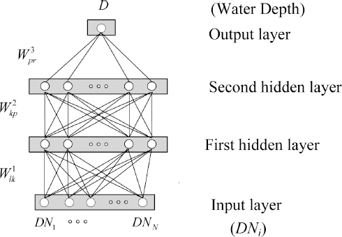
ļśÉĒĢ£ ņØ┤ ņŚ░ĻĄ¼ņŚÉņä£ļŖö ņŗĀĻ▓Įļ¦ØņØś ņØ╝ļ░śĒÖö ņä▒ļŖźņØä Ē¢źņāüņŗ£ņ╝£, ņŗĀĻ▓Įļ¦ØņØś ņ×ģļĀźņ×ÉļŻī, ņ”ē DNĻ░ÆņŚÉ ņ¢┤ļŖÉ ņĀĢļÅäņØś ņśżļźśĻ░Ć ĒżĒĢ©ļÉśņ¢┤ ņ׳ļŹöļØ╝ļÅä ņØ┤ļ¤¼ĒĢ£ ņśżļźśņŚÉ ņØśĒĢśņŚ¼ ņłśņŗ¼ņØ┤ Ļ│╝ļÅäĒĢśĻ▓ī ņÖ£Ļ│ĪļÉśņ¦Ć ņĢŖļÅäļĪØ ĒĢśļŖö ņĀĢĻĘ£ĒÖö ļ░®ļ▓Ģ(regularization method)ņØś ĒĢ£ ļ░®ļ▓ĢņØĖ ļģĖņØ┤ņ”ł ņ▓©Ļ░ĆĒĢÖņŖĄ(noise injection learning)ņØä ņĀüņÜ®ĒĢśņśĆļŗż (Matsuoka, 1992; HßĮālmstrom and Koistinen, 1992).
3. ņśłņĀ£ ĒĢ┤ņäØ
3.1 ņłśņŗ¼ ņĖĪļ¤ē ļ░Å ņśüņāü ņ┤¼ņśü
ņĄ£ĻĘ╝ ņŗ¼Ļ░üĒĢśĻ▓ī ļ░£ņāØĒĢśĻ│Ā ņ׳ļŖö ļÅÖĒĢ┤ņĢłņŚÉņä£ņØś ņ╣©ņŗØĒśäņāüņØä ņŚ░ĻĄ¼ĒĢśĻĖ░ ņ£äĒĢśņŚ¼ Ļ▓ĮņāüļČüļÅä ņÜĖņ¦äĻĄ░ ņåīņ×¼ ĒĢ£ĻĄŁĒĢ┤ņ¢æĻ│╝ĒĢÖĻĖ░ņłĀņøÉ ļÅÖĒĢ┤ņŚ░ĻĄ¼ņåī(ESRI, East Sea Research Institute) ņĀäļ®┤ņŚÉ ņ£äņ╣śĒĢ£ ĒøäņĀĢ ĒĢ┤ņłśņÜĢņןņØä ļīĆņāüņ£╝ļĪ£ Ēā£ĒÆŹ ļō▒ņŚÉ ņØśĒĢ£ ĒĢ┤ņĀĆņ¦ĆĒśĢ ļ│ĆĒÖöļź╝ ļČäņäØĒĢśĻĖ░ ņ£äĒĢ£ ĻĖ░ņ┤ł ņŚ░ĻĄ¼ļź╝ ņŗżņŗ£ĒĢśņśĆļŗż. ĒĢ┤ļŗ╣ ĒĢ┤ņŚŁņØś ņłśņŗ¼ņØä ņĖĪļ¤ēĒĢśĻĖ░ ņ£äĒĢśņŚ¼ ĒØśņłśĻ░Ć ļ¦żņÜ░ ļé«Ļ│Ā ļ░öļŗźņØ┤ ĒÅēĒÅēĒĢ£ ņåīĒśĢ Ļ│Āļ¼┤ ļ│┤ĒŖĖņŚÉ ņØīĒ¢źņĖĪņŗ¼ĻĖ░ļź╝ Ēāæņ×¼ĒĢśņŚ¼ ņłśņŗ¼ņØä ņĖĪļ¤ēĒĢśņśĆļŗż. ņØ┤ņÖĆ Ļ░ÖņØĆ ņłśņŗ¼ņĖĪļ¤ēņØĆ ņä£ļĪĀņŚÉņä£ ņĀ£ņŗ£ĒĢ£ ļ░öņÖĆ Ļ░ÖņØ┤ ĒīīļÅäņÖĆ ļ░öļ×īĻ│╝ Ļ░ÖņØĆ ļéĀņö©ņŚÉ ļö░ļźĖ ņśüĒ¢źņØä ļ¦ÄņØ┤ ļ░øĻĖ░ ļĢīļ¼ĖņŚÉ ņŻ╝ĻĖ░ņĀüņØĖ ļ¬©ļŗłĒä░ļ¦üņŚÉ ņĀüņÜ®ĒĢśĻĖ░ ņ¢┤ļĀżņÜ┤ ļ░®ļ▓ĢņØ┤ļŗż. ļśÉĒĢ£ ļÅÖņØ╝ĒĢ£ ĒĢ┤ņŚŁņŚÉņä£ ļ¼┤ņØĖĒĢŁĻ│ĄĻĖ░ņØĖ ļō£ļĪĀņŚÉ ļööņ¦ĆĒäĖ ņ╣┤ļ®öļØ╝ļź╝ ņןņ░®ĒĢśņŚ¼ ĒĢŁĻ│ĄņśüņāüņØä ĒÜŹļōØĒĢśņśĆņ£╝ļ®░, ĒĢŁĻ│Ąņ┤¼ņśüĻ│╝ Ļ┤ĆļĀ©ļÉ£ ņé¼ĒĢŁņØĆ ļŗżņØīņØś Table 2ņÖĆ Ļ░Öļŗż. ĻĘĖļ”¼Ļ│Ā Fig. 2ļŖö ļō£ļĪĀņØä ņØ┤ņÜ®ĒĢśņŚ¼ ņ┤¼ņśüĒĢ£ ĒĢŁĻ│ĄņśüņāüņŚÉ ņØīĒ¢źņĖĪņŗ¼ĻĖ░ (Table 3 ņ░ĖņĪ░)ļĪ£ ņłśņŗ¼ņØä ņĖĪņĀĢĒĢ£ ņ¦ĆņĀÉņØä Ēæ£ņŗ£ĒĢ£ Ļ▓āņ£╝ļĪ£ ņ┤Ø 22,557Ļ░£ ņ¦ĆņĀÉņŚÉ ļīĆĒĢśņŚ¼ ņłśņŗ¼ņØä ņĖĪļ¤ēĒĢśņśĆļŗż.
Table┬Ā2
Aerial imaging environments
| Items | Values |
|---|---|
| Drone model | DJI S900 |
| Digital camera model and resolution | Sony Nex7 6,000├Ś4,000 |
| Flight height and angle | 150 m, Perpendicular to the ground |
| Date | July 28, 2015 |
3.2 ņłśņŗ¼ ņĖĪļ¤ē ņ×ÉļŻī ļČäņäØ
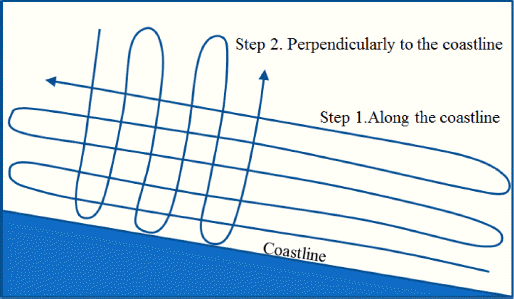
ņłśņŗ¼ ņĖĪļ¤ēņØĆ ļŗżņØī Fig. 3ņŚÉņä£ ņĀ£ņŗ£ĒĢ£ ļ░öņÖĆ Ļ░ÖņØ┤ ĒĢ┤ņĢłņäĀĻ│╝ ļéśļ×ĆĒĢ£ ļ░®Ē¢źņ£╝ļĪ£ ņĖĪļ¤ēĒĢ£ Ēøä, ņØ┤ņÖĆ ņ¦üĻĄÉļÉśļŖö ļ░®Ē¢źņ£╝ļĪ£ ĒĢ£ ļ▓ł ļŹö ņĖĪļ¤ēĒĢśņŚ¼, ņ┤Ø ļæÉ ļ▓łņŚÉ Ļ▒Ėņ│É ņłśņŗ¼ņØä ņĖĪļ¤ēĒĢśņśĆļŗż. ņØ┤ņÖĆ Ļ░ÖņØ┤ ĒĢ©ņ£╝ļĪ£ņŹ© ņä£ļĪ£ ĻĄÉņ░©ĒĢśļŖö ņ£äņ╣ś, ņ”ē ļÅÖņØ╝ĒĢ£ ņ£äņ╣śņŚÉņä£ ņĖĪļ¤ēļÉ£ ņłśņŗ¼ņØä ļ╣äĻĄÉĒĢĀ ņłś ņ׳Ļ│Ā, ņØīĒ¢źņĖĪņŗ¼ĻĖ░ļź╝ ņØ┤ņÜ®ĒĢ£ ņłśņŗ¼ ņĖĪļ¤ē ņŗ£ ļ░£ņāØ ĒĢĀ ņłś ņ׳ļŖö ņĖĪņĀĢ ĒÄĖņ░©ļź╝ ņĀĢļ¤ēņĀüņ£╝ļĪ£ ļČäņäØĒĢĀ ņłś ņ׳ļŗż. ņłśņŗ¼ ņĖĪļ¤ēņŚÉ ņ׳ņ¢┤ ļ░£ņāØĒĢĀ ņłś ņ׳ļŖö ņśżņ░©ļĪ£ļŖö ņäĀļ░Ģ ņ×Éņ▓┤ņØś ļÅÖņÜöņŚÉ ņØśĒĢ£ ņśżņ░©, GPS ņłśņŗĀ ņóīĒæ£ņŚÉ ĒżĒĢ©ļÉśņ¢┤ ņ׳ļŖö ņśżņ░©, ņØīĒ¢źņĖĪņŗ¼ĻĖ░ ņ×Éņ▓┤ņØś ņĖĪņĀĢ ņśżņ░© ļō▒ņØ┤ ņ׳ņ£╝ļ®░ ņØ┤ļ¤¼ĒĢ£ ņśżņ░© ņÜöņØĖņŚÉ ņØśĒĢśņŚ¼ ņĖĪņĀĢĒĢĀ ļĢīļ¦łļŗż ņ¢┤ļŖÉ ņĀĢļÅäņØś ņĖĪņĀĢ ĒÄĖņ░©Ļ░Ć ļ░£ņāØĒĢśļ®░, ņØ┤ļź╝ ļ¬©ļæÉ ĒżĒĢ©ĒĢ£ ņŗżņĀ£ ĒÄĖņ░©ņØś ļ▓öņ£äļź╝ ļČäņäØĒĢśņśĆļŗż.
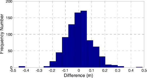
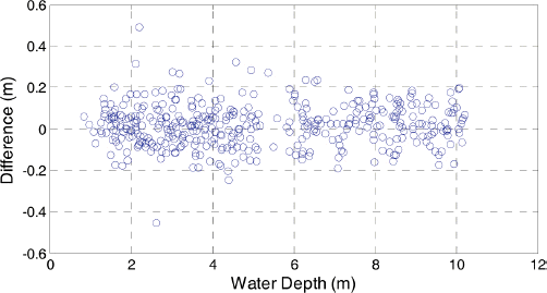
ņĢäļלņØś Fig. 4ļŖö ņä£ļĪ£ ĻĄÉņ░©ĒĢśļŖö ņ┤Ø 822Ļ░£ ņ¦ĆņĀÉņŚÉņä£ņØś ļæÉ ņ░©ļĪĆ ņĖĪļ¤ēņŚÉņä£ ĻĄ¼ĒĢ£ ņłśņŗ¼ ņĖĪļ¤ēĻ░ÆņØś ņ░©ņŚÉ ļīĆĒĢ£ ļČäĒżļź╝ ļ│┤ņŚ¼ņżĆ Ļ▓āņ£╝ļĪ£ ļæÉ ņĖĪļ¤ēĻ░Æ ņé¼ņØ┤ņØś ĒÄĖņ░©ņŚÉ ļīĆĒĢ£ ĒÅēĻĘĀņØĆ 0.006mļĪ£ ņ▓½ ļ▓łņ¦Ė ņĖĪļ¤ēĻ│╝ ļæÉ ļ▓łņ¦Ė ņĖĪļ¤ēņŚÉņä£ņØś ĒŖ╣ļ│äĒĢ£ ĒÄĖĒ¢źņä▒ņØĆ ņŚåņŚłņØīņØä ņĢī ņłś ņ׳ļŗż. ĒĢ£ĒÄĖ, ĒÄĖņ░©ņŚÉ ļīĆĒĢ£ ņĀłļīĆĻ░ÆņØś ĒÅēĻĘĀ(mean of absolute difference)Ļ│╝ RMS(Root Mean Squared)ņØĆ Ļ░üĻ░ü 0.077 m, 0.10 mļĪ£ ļČäņäØļÉśņŚłļŗż. ņĀĢĒÖĢĒĢ£ ņłśņŗ¼ņØä ĻĖ░ņżĆņ£╝ļĪ£ ĒĢ£ Ļ▓āņØ┤ ņĢäļŗłļ»ĆļĪ£ ņŚäļ░ĆĒĢ£ ņØśļ»ĖņŚÉņä£ņØś ņĖĪņĀĢ ņśżņ░©ļź╝ ļģ╝ĒĢśĻĖ░ļŖö ņ¢┤ļĀżņÜ░ļéś, ņØ┤ļ¤¼ĒĢ£ ĒåĄĻ│äĻ░ÆņØä Ļ│ĀļĀżĒĢĀ ļĢī ņ▓£ĒĢ┤ņŚŁņŚÉņä£ņØś ņłśņŗ¼ņØä ļ░śļ│Ą ņĖĪļ¤ē ņŗ£ ļ░£ņāØĒĢĀ ņłś ņ׳ļŖö ĒÄĖņ░©ņØś ņłśņżĆņØ┤ 0.08~0.10 mņ×äņØä ņĢī ņłś ņ׳ļŗż.
ĒĢ£ĒÄĖ ņłśņŗ¼ņŚÉ ļö░ļźĖ ņĖĪņĀĢ ĒÄĖņ░©ļź╝ ņĀĢļ¤ēņĀüņ£╝ļĪ£ ļČäņäØĒĢśĻĖ░ ņ£äĒĢśņŚ¼ Fig. 5ņÖĆ Ļ░ÖņØ┤ ņłśņŗ¼ņŚÉ ļö░ļźĖ ĒÄĖņ░©ļź╝ ņĀĢļ”¼ĒĢśņśĆļŗż. ņłśņŗ¼ ņ”ØĻ░ĆņŚÉ ļö░ļźĖ ĒŖ╣ļ│äĒĢ£ Ļ▓ĮĒ¢źņä▒ņØĆ ņŚåļŖö Ļ▓āņ£╝ļĪ£ ĒīÉļŗ©ļÉśļ®░, ļŗżļ¦ī ņĄ£ļīĆ ņĀłļīĆ ĒÄĖņ░©(maximum absolute difference)ļŖö ņłśņŗ¼ņØ┤ Ļ╣ŖņØäņłśļĪØ Ļ░Éņåī ĒĢśļŖö Ļ▓ĮĒ¢źņØä ļéśĒāĆļé┤Ļ│Ā ņ׳ļŗż. ĻĄ¼Ļ░äļ│äļĪ£ RMS Ļ░ÆņØä ļČäņäØĒĢśņŚ¼ ļ│┤ļ®┤, ņłśņŗ¼ņØ┤ 2 m, 2~4 m, 4~6 m, 6~8 m, 8~10 mņØĖ ĻĄ¼Ļ░äņŚÉņä£ņØś RMS Ļ░ÆņØĆ Ļ░üĻ░ü 0.0852 m, 0.1073 m, 0.1102 m, 0.1004 m, 0.0903 mļĪ£ ļČäņäØļÉśņ¢┤ ĒŖ╣ļ│äĒĢ£ Ļ▓ĮĒ¢źņØ┤ ņŚåņŚłņ£╝ļ®░, Ļ░ü ĻĄ¼Ļ░äļ│ä ņĄ£ļīĆ ņĀłļīĆĒÄĖņ░©ļŖö 0.2015 m, 0.4883 m, 0.3232 m, 0.2370 m, 0.1972 mļĪ£ ņłśņŗ¼ņØ┤ ņ”ØĻ░ĆĒĢĀņłśļĪØ Ļ░ÉņåīĒĢśļŖö Ļ▓ĮĒ¢źņØä ņ░ŠņĢäļ│╝ ņłś ņ׳ļŗż.
3.3 Beer-Lambert ļ¬©ļŹĖņŚÉ ņØśĒĢ£ ņłśņŗ¼Ļ│╝ DN Ļ░äņØś Ļ┤ĆĻ│ä
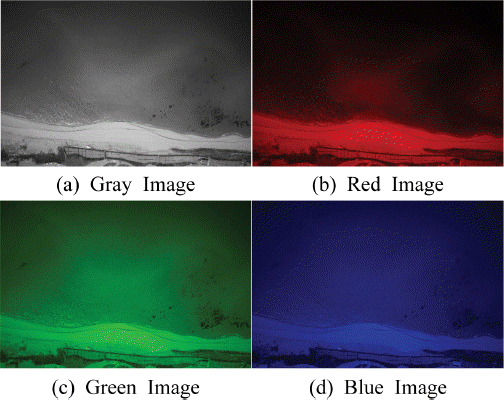
Ēā£ņ¢æĻ┤æņØĆ ņ×ÉņÖĖņäĀ, Ļ░Ćņŗ£Ļ┤æņäĀ, ņĀüņÖĖņäĀ ļō▒ ņŚ¼ļ¤¼ ĒīīņןņØä Ļ░Ćņ¦ä ĒīīļĪ£ ĻĄ¼ņä▒ļÉśņ¢┤ ņ׳ņ£╝ļ®░, ņØ┤ļ¤¼ĒĢ£ Ēā£ņ¢æĻ┤æņØ┤ ĒĢ┤ņłśņŚÉ ņ×ģņé¼ļÉśļŖö Ļ▓ĮņÜ░, ĒīīņןņØś ĒŖ╣ņä▒ņŚÉ ļö░ļØ╝ ļ░śņé¼ ļśÉļŖö ĒØĪņłśļÉśļŖö ņĀĢļÅäĻ░Ć ļŗżļź┤Ļ▓ī ļéśĒāĆļé£ļŗż. ņłśņŗ¼ņØ┤ Ļ╣ŖņØäņłśļĪØ ĒØĪņłśļÉśļŖö ņĀĢļÅäĻ░Ć Ēü¼ĻĖ░ ļĢīļ¼ĖņŚÉ Ļ▓░ĻĄŁ ļ░śņé¼ļÉ£ Ļ░ü ņŻ╝Ēīīņłśļ│ä Ļ┤æņäĀņØś ņäĖĻĖ░ļź╝ ņØ┤ņÜ®ĒĢśņŚ¼ ņłśņŗ¼ņØä ņĖĪļ¤ēĒĢĀ ņłś ņ׳Ļ▓ī ļÉ£ļŗż. ņśłļź╝ ļōżņ¢┤ Fonstad and Marcus(2005)ļŖö ņ▓Łņāē ņśüņāü ņ×ÉļŻīļź╝ ņżæņŗ¼ņ£╝ļĪ£ ņłśņŗ¼Ļ│╝ņØś Ļ┤ĆĻ│äļź╝ ņé┤ĒÄ┤ļ│┤ņĢśļŖöļŹ░, ņØ┤ ņŚ░ĻĄ¼ņŚÉņä£ ļŖö ņøÉ ņśüņāüņØś ļ░ØĻĖ░ ņĀĢļ│┤(gray scale)ļź╝ ļ╣äļĪ»ĒĢśņŚ¼, ņĀüņāē, ļģ╣ņāē, ņ▓Łņāē ņśüņāüņ£╝ļĪ£ ļČäļ”¼ĒĢ£ Ēøä, Ļ░üĻ░üņØś ņśüņāüņŚÉņä£ņØś DNĻ░ÆņØä ņØ┤ņÜ®ĒĢś ņŚ¼ ņłśņŗ¼Ļ│╝ņØś Ļ┤ĆĻ│äļź╝ ļČäņäØĒĢśņśĆļŗż. Fig. 6ņØĆ ĒÜīņāē ņśüņāüņØś DNņØä ļ╣äļĪ»ĒĢśņŚ¼ ņĀüņāē, ļģ╣ņāē, ņ▓Łņāēņ£╝ļĪ£ ļČäļ”¼ļÉ£ ņśüņāüņŚÉņä£ņØś DNņØä ņĀ£ņŗ£ĒĢ£ ĻĘĖļ”╝ņØ┤ļŗż.
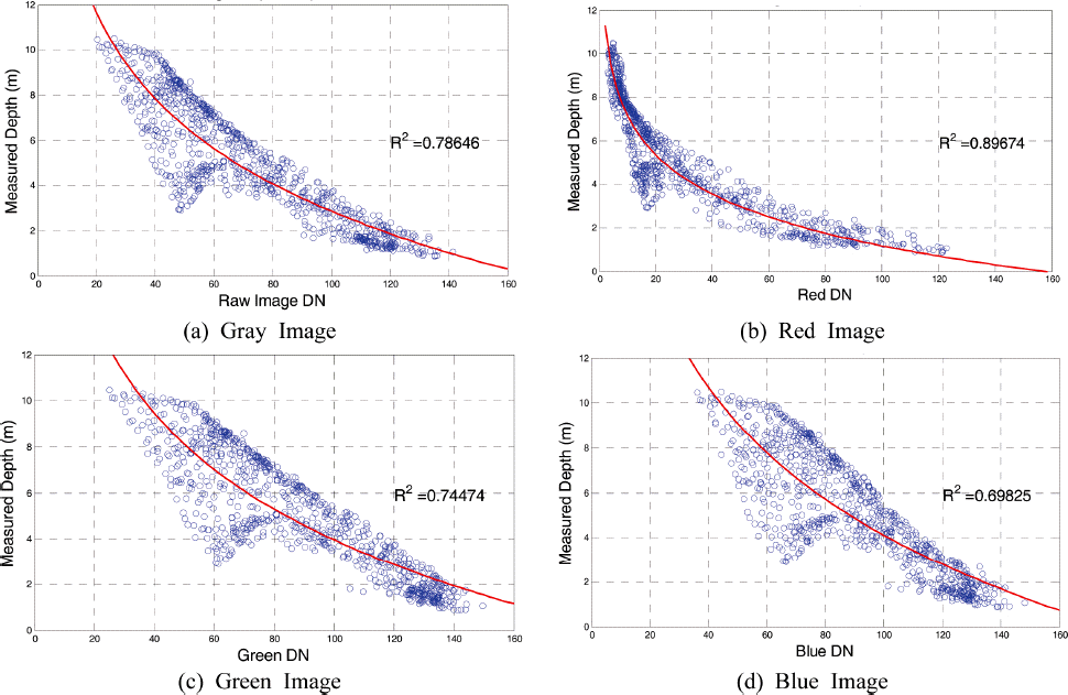
ņĢäļלņØś Fig. 7ņØĆ ņØīĒ¢źņĖĪņŗ¼ĻĖ░ļĪ£ ņłśņŗ¼ņØä ņĖĪļ¤ēĒĢ£ ņĀäņ▓┤ ņ¦ĆņĀÉņŚÉ ļīĆĒĢśņŚ¼ Ļ░üĻ░üņØś DNĻ│╝ ņłśņŗ¼ņØä ļ╣äĻĄÉĒĢ£ ĻĘĖļלĒöäļĪ£ ņŗØ (1)ņØä ņØ┤ņÜ®ĒĢśņŚ¼ ĻĄ¼ĒĢ£ ĒÜīĻĘĆņŗØ(regression equation)ņØä ņĀüņāē ņäĀņ£╝ļĪ£ ĒĢ©Ļ╗ś Ēæ£ņŗ£ĒĢśņśĆļŗż. ĻĘĖļ”╝ņŚÉņä£ ņĀ£ņŗ£ĒĢ£ ļ░öņÖĆ Ļ░ÖņØ┤ ĒÜīņāē ņśüņāüņØä ļ╣äļĪ»ĒĢśņŚ¼ ņĀüņāē, ļģ╣ņāē, ņ▓Łņāē ņśüņāüĻ│╝ DN ņé¼ņØ┤ņØś ņāüĻ┤ĆĻ│äņłś(R2)ļŖö Ļ░üĻ░ü 0.78, 0.89, 0.74, 0.69ļĪ£, ņĀüņāē ņśüņāüņØś DNņØ┤ Ļ░Ćņן ļåÆņØĆ ņāüĻ┤ĆĻ┤ĆĻ│äļź╝ Ļ░Ćņ¦ĆĻ│Ā ņ׳ņØīņØä ņĢī ņłś ņ׳ļŗż. ĒÜīņāē ņśüņāüņØś Ļ▓ĮņÜ░ ņĀüņāē, ļģ╣ņāē, ņ▓ŁņāēņØś ņĪ░ĒĢ®ņ£╝ļĪ£ ļéśĒāĆļéśļŖö ņśüņāüņØ┤ĻĖ░ ļĢīļ¼ĖņŚÉ ņĀüņāē, ļģ╣ņāē, ņ▓Łņāē ļō▒ ļŗ©ņāēĻ┤æņØś ņāüĻ┤ĆĻ┤ĆĻ│äņØś ĒÅēĻĘĀņĀüņØĖ ņØśļ»ĖļĪ£ ĒīÉļŗ©ĒĢĀ ņłś ņ׳ļŗż. ĒĢ£ĒÄĖ, ļŗ©ņāēĻ┤æņØś Ļ▓ĮņÜ░ ĻĘĖ ĒŖ╣ņä▒ņØä ĒåĄĒĢśņŚ¼ ņØ┤ļ¤¼ĒĢ£ Ļ▓░Ļ│╝ļź╝ ļČäņäØĒĢĀ ņłś ņ׳ļŗż. ņ”ē, ņĀüņāēĻ│╝ Ļ░ÖņØ┤ ĒīīņןņØ┤ ĻĖ┤ ļŗ©ņāēĻ┤æņØś Ļ▓ĮņÜ░ ĒĢ┤ņłśņŚÉ ņØśĒĢ£ ĒØĪņłśņ£©ņØ┤ ļåÆĻ│Ā, ņ▓ŁņāēĻ│╝ Ļ░ÖņØ┤ ĒīīņןņØ┤ ņ¦¦ņØĆ ļŗ©ņāēĻ┤æņØś Ļ▓ĮņÜ░ ĒØĪņłśņ£©ņØ┤ ļé«ņĢä ņłśņŗ¼ņØ┤ Ļ╣ŖņØĆ ņśüņŚŁĻ╣īņ¦Ć ņĀäļŗ¼ļÉśļŖö ĒŖ╣ņä▒ņØä Ļ░Ćņ¦Ć Ļ│Ā ņ׳ļŗż. ņØ╝ļ░śņĀüņ£╝ļĪ£ ņĀüņāēĻ┤æņØś Ļ▓ĮņÜ░ ņłśņŗ¼ 15~18 m ņĀĢļÅäļ®┤ ļ¬©ļæÉ ĒØĪņłśļÉśļ®░ ļö░ļØ╝ņä£ ĻĘĖļ│┤ļŗż Ļ╣ŖņØĆ ņłśņŗ¼ņŚÉņä£ļŖö ņĀüņāēĻ┤æņØĆ ņĀäļŗ¼ ļÉśņ¦Ć ņĢŖĻ│Ā, ļö░ļØ╝ņä£ ņØ┤ļ│┤ļŗż ļŹö Ļ╣ŖņØĆ ĒĢ┤ņŚŁņŚÉņä£ļŖö ļ¬©ļæÉ ņ▓ŁņāēĻ┤æļ¦ī ņĪ┤ņ×¼ĒĢśĻ▓ī ļÉ£ļŗż. ļö░ļØ╝ņä£ ņłśņŗ¼ņØ┤ 20 m ņØ┤ņāü Ļ╣ŖņØĆ ĒĢ┤ņŚŁņŚÉ ļīĆĒĢśņŚ¼ ņśüņāüņØä ņØ┤ņÜ®ĒĢśņŚ¼ ņłśņŗ¼ņØä ņĖĪņĀĢĒĢśļŖö Ļ▓ĮņÜ░ņŚÉļŖö ņĀüņāē ņśüņāüļ│┤ļŗżļŖö ņ▓Łņāē ņśüņāüņØ┤ ļŹö ņĀüņĀłĒĢĀ ņłś ņ׳ņ£╝ļéś, ņØ┤ ņŚ░ĻĄ¼ņŚÉņä£ ļŗżļŻ©Ļ│Ā ņ׳ļŖö ņ▓£ĒĢ┤ņŚŁņØś Ļ▓ĮņÜ░ ņĀüņāē ņśüņāüņØä ņØ┤ņÜ®ĒĢśņŚ¼ ņłśņŗ¼ņØä ņśłņĖĪĒĢĀ ļĢī Ļ░Ćņן ņĀĢĒÖĢĒĢ£ ņłśņŗ¼ ņśłņĖĪņØ┤ Ļ░ĆļŖźĒĢ©ņØä ņĢī ņłś ņ׳ļŗż. ļŗżļ¦ī ņśüņāüņ£╝ļĪ£ ņĘ©ļōØļÉśļŖö ņĀĢļ│┤ļŖö Ļ▓░ĻĄŁ ļ╣øņØ┤ ņé░ļ×ĆļÉśņ¢┤ ļéśņśżļŖö ņĀĢļ│┤ņØ┤ĻĖ░ ļĢīļ¼ĖņŚÉ ĒĢ┤ņłśņŚÉ ĒżĒĢ©ļÉśņ¢┤ ņ׳ļŖö ļŗżņ¢æĒĢ£ ļ»Ėļ”Įņ×É ļ░Å ĒĢ┤ņĀĆņ¦łņØś ĻĄ¼ņä▒ņŚÉ ļö░ ļØ╝ ņśüĒ¢źņØä ļ░øņØä ņłś ņ׳ņØä Ļ▓āņØ┤ļŗż. ņśłļź╝ ļōżņ¢┤ ļ¬©ļל ļīĆņŗĀ ņĀÉĒåĀĻ░Ć ļ¦ÄņØ┤ ĒżĒĢ©ļÉśņ¢┤ ņ׳ļŖö ņä£ļé©ĒĢ┤ņĢłņØś Ļ▓ĮņÜ░ļŖö ņØ┤ņÖĆ ļŗżļźĖ Ļ▓░Ļ│╝ļź╝ ņ¢╗ņØä ņłś ņ׳ņØä Ļ▓āņØ┤ļŗż. ĒĢ£ĒÄĖ, ĒÜīĻĘĆļČäņäØņØä ĒåĄĒĢśņŚ¼ ĻĄ¼ĒĢ£ ĒÜīņāē, ņĀüņāē, ļģ╣ņāē, ņ▓Łņāē ņśüņāüņŚÉ ļīĆĒĢ£ ĒØĪņłśņ£©(╬▓)ņØĆ Ļ░üĻ░ü 0.184, 0.386, 0.167, 0.139ļĪ£ ĒīīņןņØ┤ ĻĖ┤ ņĀüņāēĻ┤æņØś ĒØĪņłśņ£©ņØ┤ Ļ░Ćņן Ēü¼Ļ▓ī, ĻĘĖļ”¼Ļ│Ā ĒīīņןņØ┤ ņ¦¦ņØĆ ņ▓ŁņāēĻ┤æņØś ĒØĪņłśņ£©ņØ┤ Ļ░Ćņן ņ×æĻ▓ī ļČäņäØļÉśņ¢┤ ĻĖ░ņĪ┤ ļŗ©ņāēĻ┤æņØś ĒØĪņłśņ£©ņŚÉ ļīĆĒĢ£ Ļ▓ĮĒ¢źĻ│╝ ļÅÖņØ╝ĒĢ£ Ļ▓░Ļ│╝ļź╝ ņ¢╗ņØä ņłś ņ׳ņŚłļŗż. ļśÉĒĢ£ ņŗØ (2)ņŚÉņä£ ņĀ£ņŗ£ļÉśņ¢┤ ņ׳ļŖö DN0ņØś Ļ▓ĮņÜ░, ĒÜīņāē, ņĀüņāē, ļģ╣ņāē, ņ▓Łņāē ņśüņāüņŚÉ ļīĆĒĢśņŚ¼ Ļ░üĻ░ü 169, 157, 193, 176ņ£╝ļĪ£ ļČäņäØ ļÉśņŚłņ£╝ļ®░, ņØ┤ Ļ░ÆņØĆ ņłśņŗ¼ņØ┤ 0ņØĖ Ļ▓ĮņÜ░, ņ”ē ĒĢ┤ņĢłņäĀņŚÉņä£ņØś Ļ░ü ņśüņāüņØś DNĻ░Æņ£╝ļĪ£ ļģ╣ņāēĻ┤æņØś DNĻ░ÆņØ┤ Ļ░Ćņן Ēü╝ņØä ņĢī ņłś ņ׳ļŗż.
3.4 ANNņØä ņØ┤ņÜ®ĒĢ£ DNĻ│╝ ņłśņŗ¼ ņé¼ņØ┤ņØś Ļ┤ĆĻ│ä ļČäņäØ
ņØ┤ ņĀłņŚÉņä£ļŖö ļŗżņ¢æĒĢ£ ĻĄ¼ņĪ░ņØś ņŗĀĻ▓Įļ¦ØņØä ņØ┤ņÜ®ĒĢśņŚ¼ Ļ░ü ņśüņāüņØś DNĻ│╝ ņĖĪņĀĢļÉ£ ņłśņŗ¼ ņé¼ņØ┤ņØś Ļ┤ĆĻ│äļź╝ ļČäņäØĒĢśĻ│Āņ×É ĒĢśņśĆļŗż. ņ┤Ø 4Ļ░£ ņØś ņŗĀĻ▓Įļ¦Ø ĻĄ¼ņĪ░ļź╝ ņØ┤ņÜ®ĒĢśņśĆļŖöļŹ░, Ļ░üĻ░üņØś ņŗĀĻ▓Įļ¦Ø ĻĄ¼ņĪ░ņŚÉņä£ ņé¼ņÜ®ļÉ£ ņ×ģļĀźņ×ÉļŻīņÖĆ ņØĆļŗēņĖĄ ļē┤ļ¤░ņØś ņłśļŖö Table 4ņÖĆ Ļ░Öļŗż. ņ”ē ņ▓½ ļ▓łņ¦Ė ņŗĀĻ▓Įļ¦ØņØś Ļ▓ĮņÜ░ ļ¬©ļōĀ DN ņ×ÉļŻīļź╝ ņØ┤ņÜ®ĒĢśļŖö Ļ▓āņ£╝ļĪ£ ņ▓½ ļ▓ł ņ¦Ė, ļæÉ ļ▓łņ¦Ė ņØĆļŗēņĖĄņŚÉ ņé¼ņÜ®ļÉ£ ļē┤ļ¤░ņØĆ Ļ░üĻ░ü 6Ļ░£, 4Ļ░£ņØ┤ļ®░, ļæÉ ļ▓łņ¦Ė ņŗĀĻ▓Įļ¦ØņØś Ļ▓ĮņÜ░ļŖö ĒÜīņāēņśüņāüņØä ņØ┤ņÜ®ĒĢ£ Ļ▓ĮņÜ░, ņäĖ ļ▓łņ¦Ė ņŗĀĻ▓Į ļ¦ØņØĆ Beer-Lambert ļ¬©ļŹĖņØä ņĀüņÜ®ĒĢśņśĆņØä ļĢī Ļ░Ćņן ļåÆņØĆ ņāüĻ┤ĆĻ┤Ć Ļ│äļź╝ Ļ░Ćņ¦ä Ļ▓āņ£╝ļĪ£ ļČäņäØļÉ£ ņĀüņāē ņśüņāüņŚÉņä£ņØś DN ņ×ÉļŻīļź╝ ņØ┤ņÜ® ĒĢśļŖö Ļ▓āņØ┤ļ®░, ļäż ļ▓łņ¦Ė ņŗĀĻ▓Įļ¦ØņØĆ ņĀüņāē, ļģ╣ņāē, ņ▓Łņāē ņśüņāüņŚÉņä£ņØś DN ņ×ÉļŻīļź╝ ņØ┤ņÜ®ĒĢśļŖö Ļ▓āņØ┤ļŗż. ņØ┤ņÖĆ ļŗżļźĖ ņŗĀĻ▓Įļ¦Ø ĻĄ¼ņĪ░ ļ░Å ņØĆļŗē ņĖĄņŚÉ ņé¼ņÜ®ļÉ£ ļē┤ļ¤░ ņłśņŚÉ ļö░ļźĖ Ļ▓░Ļ│╝ļÅä ļ╣äĻĄÉĒĢĀ ņłś ņ׳ņ£╝ļéś, ņØ┤ ņŚ░ĻĄ¼ņŚÉņä£ļŖö ņŚ¼ļ¤¼ ņŗĀĻ▓Įļ¦Ø ĻĄ¼ņĪ░ ņżæ ļīĆĒæ£ņä▒ņØä Ļ░Ćņ¦ä ļäż Ļ░£ ņŗĀĻ▓Įļ¦ØņŚÉ ļīĆĒĢśņŚ¼ ĻĘĖ ņä▒ļŖźņØä ĒÅēĻ░ĆĒĢśļŖö Ļ▓āņ£╝ļĪ£ ĒĢ£ņĀĢĒĢśņśĆļŗż.
Table┬Ā4
ANNs for bathymetry estimation
| Cases | Input Data | Number of Neurons in 1st and 2nd Hidden Layers |
|---|---|---|
| 1 | Gray, Red, Green, Blue | 6, 4 |
| 2 | Gray | 4, 4 |
| 3 | Red | 4, 4 |
| 4 | Red, Green, Blue | 6, 4 |
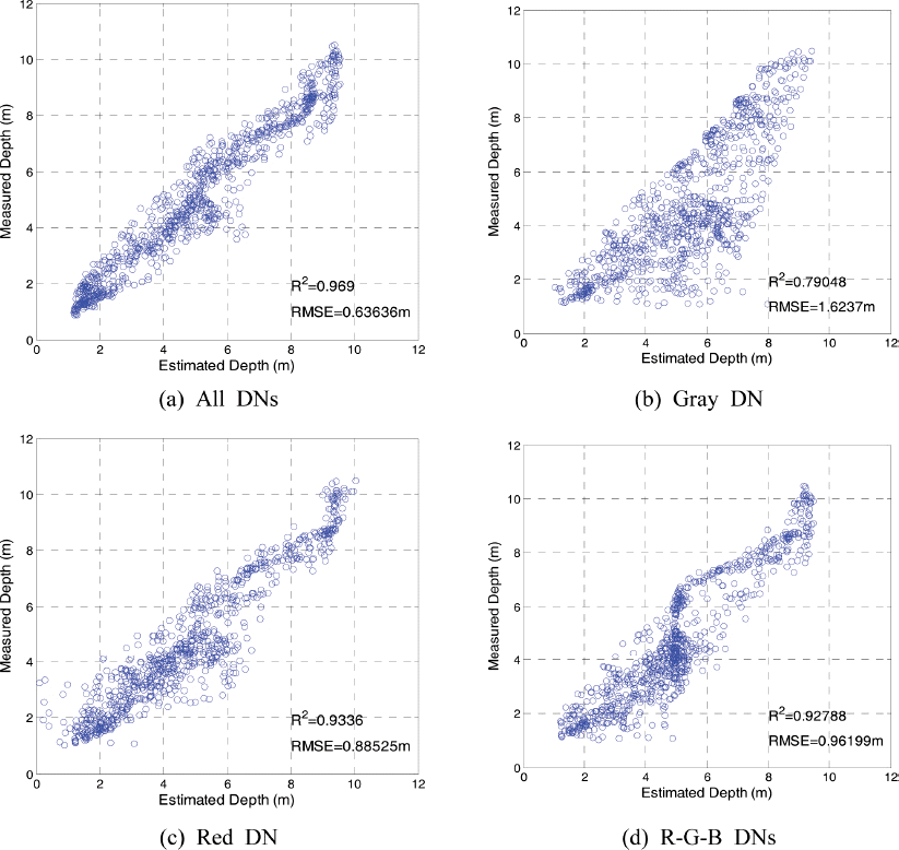
Fig. 8ņØĆ ņØīĒ¢źņĖĪņŗ¼ĻĖ░ļź╝ ņØ┤ņÜ®ĒĢśņŚ¼ ņĖĪņĀĢĒĢ£ ņłśņŗ¼(measured depth)Ļ│╝ Table 4ņŚÉņä£ ņĀ£ņŗ£ĒĢ£ ļäż Ļ░Ćņ¦Ć ĒśĢĒā£ņØś ņŗĀĻ▓Įļ¦Ø ĻĄ¼ņĪ░ļź╝ ņØ┤ņÜ®ĒĢśņŚ¼ Ļ░äņĀæņĀüņ£╝ļĪ£ ņłśņŗ¼ņØä ņśłņĖĪĒĢ£ Ļ▓░Ļ│╝(estimated depth)ļź╝ ļ╣äĻĄÉĒĢ£ ĻĘĖļלĒöäņØ┤ļŗż. ļäż ņŗĀĻ▓Įļ¦Ø ĻĄ¼ņĪ░ ņżæ Ļ░Ćņן ļåÆņØĆ ņāüĻ┤ĆĻ┤ĆĻ│äļź╝ ļ│┤ņŚ¼ņŻ╝Ļ│Ā ņ׳ļŖö Ļ▓āņØĆ ļ¬©ļōĀ DN ņĀĢļ│┤ļź╝ ņØ┤ņÜ®ĒĢ£ ņ▓½ ļ▓łņ¦Ė ņŗĀĻ▓Įļ¦Øņ£╝ļĪ£, ņØ┤ ļĢī R2 =0.97ļĪ£ ļ¦żņÜ░ ļåÆņØĆ ņāüĻ┤ĆĻ┤ĆĻ│äļź╝ Ļ░Ćņ¦ĆĻ│Ā ņ׳ņ£╝ļ®░, ļśÉĒĢ£ RMS ņśżņ░© ņŚŁņŗ£ 0.63 m ņłśņżĆņ£╝ļĪ£ ļŗżļźĖ ņŗĀĻ▓Įļ¦ØņØś Ļ▓░Ļ│╝ļ│┤ļŗżļŖö ļåÆņØĆ ņĀĢĒÖĢņä▒ņØä ļ│┤ņŚ¼ņŻ╝Ļ│Ā ņ׳ļŗż. ļśÉĒĢ£ ĒÜīņāē ņĀĢļ│┤ļ¦ī ņé¼ņÜ®ĒĢ£ Ļ▓ĮņÜ░, Fig. 8(b)ņŚÉņä£ņÖĆ Ļ░ÖņØ┤ ļŗżļźĖ Ļ▓ĮņÜ░ņŚÉ ļ╣äĒĢśņŚ¼ Ēü░ ņśżņ░©ļź╝ Ļ░Ćņ¦ĆĻ│Ā ņ׳ņØīņØä ņĢī ņłś ņ׳ļŗż. ņØ┤ļŖö ĒÜīņāē ņĀĢļ│┤ļ¦īņØä ņé¼ņÜ®ĒĢśļŖö Ļ▓ĮņÜ░ Beer-Lambert Ļ│ĄņŗØņØä ņĀüņÜ®ĒĢśņśĆņØä ļĢī ņ¢╗ņØä ņłś ņ׳ņŚłļŹś Ļ▓░Ļ│╝, ņ”ē Ļ░Ćņן ņāüĻ┤ĆĻ┤ĆĻ│äĻ░Ć ļåÆņØĆ ņĀüņāē ņĀĢļ│┤ļź╝ ļ░░ņĀ£ĒĢśņśĆĻĖ░ ļĢīļ¼ĖņØĖ Ļ▓āņ£╝ ļĪ£ ņé¼ļŻīļÉ£ļŗż. ĒĢ£ĒÄĖ Fig. 8ņØś Ļ▓░Ļ│╝ļź╝ ĒåĄĒĢśņŚ¼ ĒīÉļŗ©ĒĢĀ ļĢī ņØīĒ¢źņĖĪ ņŗ¼ĻĖ░ļź╝ ņØ┤ņÜ®ĒĢ£ ņłśņŗ¼ ņĖĪļ¤ē Ļ▓░Ļ│╝ņÖĆļŖö ļīĆļץ ┬▒1 mņØś ĒÄĖņ░©ļź╝ Ļ░Ćņ¦Ć Ļ│Ā ņ׳ņØīņØä ņĢī ņłś ņ׳ļŗż. ņśłļź╝ ļōżņ¢┤ ņØīĒ¢źņĖĪņŗ¼ĻĖ░ņØś Ļ▓░Ļ│╝ļź╝ ņĀĢĒÖĢ ĒĢ£ ņłśņŗ¼ņØ┤ļØ╝Ļ│Ā Ļ░ĆņĀĢĒĢĀ ļĢī, ņłśņŗ¼ 5 mņØĖ ņ¦ĆņĀÉņŚÉņä£ ņŗĀĻ▓Įļ¦ØņØä ņØ┤ ņÜ®ĒĢśņŚ¼ ņśłņĖĪĒĢ£ ņłśņŗ¼ņØĆ 4~6 mĻ╣īņ¦Ć ņśłņĖĪļÉĀ ņłś ņ׳ņØīņØä ņØśļ»ĖĒĢ£ļŗż. ļö░ļØ╝ņä£ ņČöĻ░ĆņĀüņØĖ ņŚ░ĻĄ¼ļź╝ ĒåĄĒĢśņŚ¼ ņØ┤ļ¤¼ĒĢ£ ņśżņ░©ļź╝ ņżäņØ╝ ņłś ņ׳ļÅäļĪØ ņŗĀĒśĖņ▓śļ”¼ ļ░®ļ▓ĢņØä Ļ░£ņäĀĒĢĀ ĒĢäņÜöĻ░Ć ņ׳ņØä Ļ▓āņ£╝ļĪ£ ņé¼ļŻīļÉ£ļŗż.
4. Ļ▓░ļĪĀ
ņØ┤ ļģ╝ļ¼ĖņŚÉņä£ļŖö Ēā£ĒÆŹ ļō▒ņŚÉ ņØśĒĢ£ ņŚ░ņĢłņ╣©ņŗØņØ┤ ļ╣łļ▓łĒĢśĻ▓ī ļ░£ņāØĒĢśĻ│Ā ņ׳ļŖö ļÅÖĒĢ┤ņĢłņØś ĒŖ╣ņĀĢ ņ▓£ĒĢ┤ņŚŁņØä ļīĆņāüņ£╝ļĪ£ ĒĢŁĻ│Ąņé¼ņ¦äņØä ņØ┤ņÜ®ĒĢ£ ņłśņŗ¼ ņĖĪļ¤ēņŚÉ Ļ┤ĆĒĢ£ ņŚ░ĻĄ¼ ļé┤ņÜ®ņØä ņåīĻ░£ĒĢśņśĆļŗż.
(1) ņłśņŗ¼ 10 m ņØ┤ļé┤ņØś ņ▓£ĒĢ┤ņŚŁņŚÉņä£ ņØīĒ¢źņĖĪņŗ¼ĻĖ░ļź╝ ņØ┤ņÜ®ĒĢ£ ņłśņŗ¼ ņĖĪļ¤ēņØä ņ£äĒĢśņŚ¼ ĒØśņłśĻ░Ć ļé«ņØĆ ņäĀļ░ĢņŚÉ ņØīĒ¢źņĖĪņŗ¼ĻĖ░ ņןņ╣śļź╝ Ēāæņ×¼ĒĢśņŚ¼ ļīĆņāü ĒĢ┤ņŚŁņØĖ ĒøäņĀĢ ĒĢ┤ņłśņÜĢņן ņĀäļ®┤ ĒĢ┤ņŚŁņØś ņłśņŗ¼ņØä ņĖĪļ¤ē ĒĢśņśĆņ£╝ļ®░, ņØ┤ļĢī ņłśņŗ¼ ņĖĪļ¤ēņØś ņĀĢĒÖĢļÅäļź╝ ņĀĢļ¤ēņĀüņ£╝ļĪ£ ļČäņäØĒĢśĻĖ░ ņ£äĒĢśņŚ¼ ĒĢ┤ņĢłņäĀ ļ░®Ē¢źņ£╝ļĪ£ ĒĢ£ ņ░©ļĪĆ, ĻĘĖļ”¼Ļ│Ā ĒĢ┤ņĢłņäĀ ņ¦üĻĄÉ ļ░®Ē¢źņ£╝ļĪ£ ļśÉĒĢ£ ņ░©ļĪĆ ņĖĪņĀĢņØä ņłśĒ¢ēĒĢśņśĆļŗż. ĻĄÉņ░©ņĀÉņŚÉņä£ ļæÉ ņ░©ļĪĆ ņĖĪņĀĢļÉ£ ņ×ÉļŻīļź╝ ļ╣äĻĄÉĒĢ£ Ļ▓░Ļ│╝ ņĀłļīĆņśżņ░©ņØś ĒÅēĻĘĀĻ│╝ RMS ņśżņ░©ļŖö Ļ░üĻ░ü 0.077 m, 0.10 mļĪ£ ļČäņäØļÉśņŚłņ£╝ļ®░, ņłśņŗ¼ņŚÉ ļö░ļźĖ Ļ▓ĮĒ¢źņØĆ ņŚåņŚłļŗż. ĻĘĖļ¤¼ļéś ņĄ£ļīĆ ņśżņ░©ņØś Ļ▓ĮņÜ░ ņłśņŗ¼ņØ┤ Ļ╣ŖņØäņłśļĪØ Ļ░ÉņåīĒĢśļŖö Ļ▓ĮĒ¢źņØä ņ░ŠņĢäļ│╝ ņłś ņ׳ņŚłļŗż.
(2) Beer-Lambert Ļ│ĄņŗØņØä ņØ┤ņÜ®ĒĢśņŚ¼ ĒÜīņāē, ņĀüņāē, ļģ╣ņāē, ņ▓Łņāē ņśüņāüņŚÉ ļīĆĒĢ£ DNĻ│╝ ņłśņŗ¼ ņé¼ņØ┤ņØś Ļ┤ĆĻ│äļź╝ ļČäņäØĒĢśņśĆņ£╝ļ®░, Ļ░üĻ░üņØś R2Ļ░ÆņØĆ 0.78, 0.89, 0.74, 0.69ļĪ£ ļČäņäØļÉśņ¢┤, ņĀüņāē ņśüņāüņØś DNņØ┤ ņłśņŗ¼Ļ│╝ Ļ░Ćņן ļåÆņØĆ ņāüĻ┤ĆĻ┤ĆĻ│äļź╝ Ļ░Ćņ×ÉĻ│Ā ņ׳ņØīņØä ņĢī ņłś ņ׳ņŚłļŗż.
(3) Beer-Lambert Ļ│ĄņŗØņØś ļīĆņĢłņ£╝ļĪ£ ņŗĀĻ▓Įļ¦ØņØä ņØ┤ņÜ®ĒĢ£ Ļ┤ĆĻ│äļź╝ ļČäņäØĒĢśņśĆļŗż. ļäż Ļ░Ćņ¦Ć ĻĄ¼ņĪ░ņØś ņä£ļĪ£ ļŗżļźĖ ņŗĀĻ▓Įļ¦ØņØä ņØ┤ņÜ®ĒĢśņśĆņ£╝ļ®░, Ļ░üĻ░üņØś ņŗĀĻ▓Įļ¦ØņØĆ ņ×ģļĀźņ×ÉļŻīļĪ£ (1) ĒÜīņāē, ņĀüņāē, ļģ╣ņāē, ņ▓Łņāē ņśüņāüņØś DN, (2) ĒÜīņāē DN, (3) ņĀüņāē DN, (4) ņĀüņāē, ļģ╣ņāē, ņ▓Łņāē ņśüņāüņØś DNņØä ņé¼ņÜ®ĒĢśņśĆļŗż. ņØ┤ļĢī Ļ░üĻ░üņØś ņŗĀĻ▓Įļ¦ØņØä ņØ┤ņÜ®ĒĢśņŚ¼ Ļ░ä ņĀæņĀüņ£╝ļĪ£ ņČöņĀĢĒĢ£ ņłśņŗ¼Ļ│╝ ņŗżņĀ£ ņĖĪļ¤ē ņłśņŗ¼ ņé¼ņØ┤ņØś R2Ļ░ÆņØĆ 0.97, 0.79, 0.93, 0.93ņ£╝ļĪ£ ļ¬©ļōĀ ņ×ÉļŻīļź╝ ņØ┤ņÜ®ĒĢśņśĆņØä ļĢī Ļ░Ćņן ļåÆņØĆ ņāüĻ┤ĆĻ│äņłśļź╝ Ļ░Ćņ¦ĆĻ│Ā ņ׳ņŚłņ£╝ļ®░, ļśÉĒĢ£ RMS ņśżņ░© ņŚŁņŗ£ Ļ░Ćņן ņ×æņØĆ ņłśņżĆņØä Ļ░Ćņ¦ĆĻ│Ā ņ׳ņØīņØä ņĢī ņłś ņ׳ņŚłļŗż.
ņČöĒøä ņŚ░ĻĄ¼Ļ│╝ņĀ£ļĪ£ļŖö (1) ņŻ╝ĻĖ░ņĀüņØĖ ņśüņāüņ×ÉļŻīļź╝ ĒÖĢļ│┤ĒĢśņŚ¼, ļéĀņö© ļō▒ ņÖĖļČĆ ņĪ░Ļ▒┤ņŚÉ ņØśĒĢ£ ņśüĒ¢źņØä ņĄ£ņåīĒÖöĒĢĀ ņłś ņ׳ļŖö ņśüņāüņ▓śļ”¼ĻĖ░ ņłĀņØä Ļ░£ļ░£ĒĢśļŖö Ļ▓āĻ│╝ ĒĢ©Ļ╗ś (2) ņŗżņĀ£ Ēā£ĒÆŹĻ│╝ Ļ░ÖņØĆ ņØ┤ļ▓żĒŖĖ ņĀäĒøäņØś ņśüņāüņ×ÉļŻīļź╝ ļČäņäØĒĢśņŚ¼ ņØ┤ļ¤¼ĒĢ£ ņśüņāü ĻĖ░ļ░śņØś ņłśņŗ¼ ņĖĪļ¤ē ĻĖ░ņłĀ ņØ┤ ĒĢ┤ņĀĆņ¦ĆĒśĢ ļ│ĆĒÖöļź╝ ļČäņäØĒĢśļŖöļŹ░ ņ¢┤ļŖÉ ņĀĢļÅä ĻĖ░ņŚ¼ĒĢĀ ņłś ņ׳ļŖöņ¦Ć ļō▒ņØä ĒÅēĻ░ĆĒĢśļŖö ļé┤ņÜ®ņØ┤ ņ׳ļŗż. ļśÉĒĢ£ ĻĖ░ņłĀņĀüņØĖ ļ¼ĖņĀ£ļĪ£ (3) ĒīīļÅäņÖĆ ņłśņ┤ł, ļ░öņ£ä ļō▒ņØ┤ ņ׳ļŖö Ļ▓ĮņÜ░ ņØ┤ļ¤¼ĒĢ£ ņśüĒ¢źņØä ļ░░ņĀ£ĒĢĀ ņłś ņ׳ļŖö ĻĖ░ņłĀĻ│╝ ĒĢ©Ļ╗ś (4) ņ┤¼ņśüļÉ£ ņśüņāü ļé┤ņŚÉ ņĪ┤ņ×¼ĒĢĀ ņłś ņ׳ļŖö ļ░ØĻĖ░ņØś ĒÄĖņ░© ļ░Å ĒĢ┤ņĀĆņ¦łņØś ņśüĒ¢źņØä ĒĢ┤Ļ▓░ĒĢĀ ņłś ņ׳ļŖö ĻĖ░ņłĀ ņŚŁņŗ£ ņŗżņĀ£ ņĀüņÜ®ņØä ņ£äĒĢśņŚ¼ Ļ░£ļ░£ņØ┤ ĒĢäņÜöĒĢĀ Ļ▓āņ£╝ļĪ£ ņé¼ļŻīļÉ£ļŗż.


