


1. ņŚ░ĻĄ¼ļ░░Ļ▓Į ļ░Å ļ¬®ņĀü
ĒĢŁĻ│Ąņé¼ņ¦äņØĆ ņ¦ĆĒśĢļČäņäØĻ│╝ ņ×ÉņŚ░ņ×¼ĒĢ┤ Ļ┤Ćļ”¼ļź╝ ņ£äĒĢ£ ļīĆĒæ£ņĀüņØĖ ĻĖ░ņ┤łņ×ÉļŻīņØ┤ļŗż. 1911ļģä ļÅģņØ╝ņØś Carl Zeissņé¼Ļ░Ć Ļ░£ļ░£ĒĢ£ ĻĖ░Ļ│äņŗØ ļÅäĒÖöĻĖ░ ĻĖ░ļ░śņØś ņĢäļéĀļĪ£ĻĘĖ ņé¼ņ¦äņĖĪļ¤ēņØ┤ ņ¦ĆĒśĢļČäņĢ╝ņŚÉņä£ ņé¼ņÜ®ļÉ£ ņØ┤ļלļĪ£, 1980ļģäļīĆ ļÅäņ×ģļÉ£ Bundle adjustmentņØś ļČäņäØņØä ĒåĄĒĢ£ ĒĢ┤ņäØņé¼ņ¦äņĖĪļ¤ē ļ░Å ļööņ¦ĆĒäĖņé¼ņ¦äņĖĪļ¤ēņØś ņŗ£ļīĆļź╝ Ļ▒░ņ╣śļ®┤ņä£ ņ┤łĻĖ░ņØś ņ¦ĆĻ░üņÜ┤ļÅÖņØś ņśüĒ¢źņØä ļ░øņØĆ ņ¦ĆĒśĢ(Tectonic landform) ņŚ░ĻĄ¼ņŚÉņä£ļČĆĒä░ ņ¦Ćņ¦łĻĄ¼ņĪ░ņŚÉ ņ¦Ćļ░░ļŗ╣ĒĢśļŖö ņ¦ĆĒśĢ(Structurally controlled landform)ņŚ░ĻĄ¼ņŚÉ ņØ┤ļź┤ĻĖ░Ļ╣īņ¦Ć ļäÉļ”¼ ĒÖ£ņÜ®ļÉśĻ│Ā ņ׳ļŗż(Lin and Oguchi, 2002).
ļśÉĒĢ£ ĒĢŁĻ│Ąņé¼ņ¦äņØĆ ņ×ÉņŚ░ņ×¼ĒĢ┤ ļČäņĢ╝ņØś ĒÖŹņłś, ĒĢ┤ņØ╝ ļ░Å ņ¦Ćņ¦ä ļō▒Ļ│╝Ļ░ÖņØ┤ ļīĆļ®┤ņĀüņØ┤ļéś ļŗ©ņØ╝ ņ£ĀĒśĢņØś ņ×¼ĒĢ┤ ĒśäĒÖ®ņØä ĒīīņĢģĒĢśļŖöļŹ░ ņżæņÜöĒĢ£ ņłśļŗ©ņ£╝ļĪ£ ĒÖ£ņÜ®ļÉśĻ│Ā ņ׳ļŗż. ĒŖ╣Ē׳ ņ×¼ĒĢ┤ ņĀä┬ĘĒøäņØś ĒśäĒÖ®ņŚÉ ļīĆĒĢ£ļ╣äĻĄÉļ│ĆĒÖöļź╝ ĒåĄĒĢ┤ņä£ Ēö╝ĒĢ┤ņ£Āļ¼┤ņØś ĒīÉņĀĢņŚÉ ņŻ╝ļĪ£ ņØ┤ņÜ®ļÉśņ¢┤ ņÖöļŗż(Sugito et al., 2012; Su and Stoher, 2000; Strozii et al.,2013; Shimizu, 1983).
ņĄ£ĻĘ╝ ņ×ÉņŚ░ņ×¼ĒĢ┤ņŚÉ ļīĆĒĢ£ ņé¼ĒÜīņĀü ņØĖņŗØņØ┤ ļ░®ņ×¼ņŚÉņä£ Ļ░Éņ×¼(µĖøńüĮ)ņØś Ļ░£ļģÉņ£╝ļĪ£ ņĀäĒÖśļÉśļ®┤ņä£ ņ×¼ĒĢ┤ņ£äĒŚśņØä ņé¼ņĀäņŚÉ ĒīīņĢģĒĢśĻ│Āņ×É ĒĢśļŖö ļģĖļĀźņØ┤ ņŗ£ļÅäļÉśĻ│Ā ņ׳ļŗż. ļÅäņŗ£ņāØĒÖ£ĻČīņØś ļÅäņŗ¼ ļé┤ ņé░ņ¦Ć ĒåĀņé¼ņ×¼ĒĢ┤ ļśÉĒĢ£ ņØ┤ļ¤¼ĒĢ£ Ļ░£ļģÉņØś ļ░®ņ×¼Ē¢ēņĀĢņØ┤ ņÜöĻĄ¼ļÉśņ¢┤ ņé░ņ¦Ćņé¼ļ®┤ņØś ļČĢĻ┤┤ņĀäņĪ░ĒśäņāüņØä ņłśņøöĒĢśĻ▓ī ĒīīņĢģĒĢśĻ│Āņ×É ĒĢśļŖö ļģĖļĀźņØ┤ ņŗ£ļÅäļÉśĻ│Ā ņ׳ļŗż(Kim and Jang, 2014; Kim et al., 2013).
ņØ╝ļ░śņĀüņØĖ ĒĢŁĻ│Ąņé¼ņ¦äņØś ĒīÉļÅģņØĆ ļīĆņ▓┤ļĪ£ 6Ļ░£ ļśÉļŖö 9Ļ░£ņØś ĒīÉļÅģņÜöņåīņŚÉ ņØśĒĢ┤ ņØ┤ļŻ©ņ¢┤ņ¦ĆļŖöļŹ░, Ēæ£ļ®┤ņĀüņ£╝ļĪ£ ĒśĢņāüĻ│╝ ĒŖ╣ņ¦ĢņØ┤ ļ¬ģĒÖĢĒĢ£ ĒśäņāüņØĆ ņØ┤ļōż ĒīÉļÅģņÜöņåī ņĀüņÜ®ņŚÉ ņØśĒĢ┤ Ļ│ĀņĀĢļ░ĆļÅäņØś ĒīÉļÅģĻ▓░Ļ│╝ļź╝ ļÅäņČ£ĒĢĀ ņłś ņ׳ļŗż(Kim, 1976). ņØ┤ņŚÉ ļ░śĒĢ┤ ņ×¼ĒĢ┤ļ░£ņāØ ņĀäņØś ņé░ņé¼Ēā£Ļ┤ĆļĀ© ņĀäņĪ░ĒśäņāüņØĆ ĒŖ╣ņ¦ĢņØ┤ ļ¬ģĒÖĢĒĢśņ¦Ć ņĢŖņĢä ņŻ╝ļ│Ćņ¦ĆĒśĢĻ│╝ņØś ļ│ĄĒĢ®ņĀü ĒĢ┤ņäØņØ┤ ņÜöĻĄ¼ļÉśņ¦Ćļ¦ī, ņØ┤ņŚÉ ĒĢäņÜöĒĢ£ ĒĢ┤ņäØĻ│╝ņĀĢņØĆ ņ▓┤Ļ│äĒÖö ļÉśņ¢┤ņ׳ņ¦Ć ņĢŖņØĆ ņŗżņĀĢņØ┤ļŗż.
ņØ┤ļ¤¼ĒĢ£ ļ░░Ļ▓Įņ£╝ļĪ£ļČĆĒä░ ņØ┤ ņŚ░ĻĄ¼ņŚÉņä£ļŖö ļööņ¦ĆĒäĖ ĒĢŁĻ│Ąņé¼ņ¦ä ņĖĪļ¤ēĻĖ░ļ▓ĢņØä ņØ┤ņÜ®ĒĢśņŚ¼ ņé░ņ¦ĆĒåĀņé¼ņ×¼ĒĢ┤ ļ░®ņ¦ĆļČäņĢ╝ņØś ļ»Ėņ¦ĆĒśĢļČäņäØņŗ£ ņÜöĻĄ¼ļÉśļŖö ĒīÉļÅģĻĖ░ļ▓ĢņØś ņĀĢļ”ĮņØä ņ£äĒĢ┤ ļööņ¦ĆĒäĖ ĒĢŁĻ│Ąņé¼ņ¦äņØś ĒīÉļÅģņĀłņ░©, ĒīÉļÅģņ¦ĆĒæ£ ļ░Å ĒīÉļÅģļÅä ņ×æņä▒ņØś ņ▓┤Ļ│äĒÖöļź╝ ņĀ£ņĢłĒĢśņśĆļŗż.
2. ņŚ░ĻĄ¼ņé¼
ņØ┤ ņŚ░ĻĄ¼ņÖĆ Ļ┤ĆļĀ©ļÉ£ ņŚ░ĻĄ¼ņé¼ļŖö Ēü¼Ļ▓ī ņ¦ĆĒśĢĒĢÖ ļČäņĢ╝ņÖĆ ĒĢŁĻ│Ąņé¼ņ¦äņĖĪļ¤ē ļČäņĢ╝ļĪ£ ĻĄ¼ļČäĒĢĀ ņłś ņ׳ļŗż. ļ©╝ņĀĆ ņ¦ĆĒśĢĒĢÖ ļČäņĢ╝ņŚÉņä£ļŖö ņ¦ĆĒśĢĻ│ĄĒĢÖņĀü Ļ┤ĆņĀÉņŚÉņä£ņØś ņ¦ĆĒśĢĻ│äņĖĪĻĖ░ļ▓ĢņØä ņØ┤ņÜ®ĒĢ£ ņ¦ĆĒśĢļČäļźś ņŚ░ĻĄ¼ņÖĆ ņ×ÉņŚ░ņ×¼ĒĢ┤ ņśłņ¦Ć, ļ░®ņ×¼ļź╝ ņ£äĒĢ£ ņ¦ĆĒśĢņ¦ĆĒæ£ņØś Ļ░£ļ░£ ļ░Å ĒÖ£ņÜ®ņŚÉ Ļ┤ĆĒĢ£ ņŚ░ĻĄ¼Ļ░Ć ņ¦äĒ¢ēļÉśņŚłļŗż. ņ¦ĆĒśĢļČäļźśņŚÉ Ļ┤ĆĒĢ£ ņé¼ļĪĆļź╝ ļ│┤ļ®┤ Demek and Embleton(1978)ņØś ļŗĄņé¼, ĒĢŁĻ│Ąņé¼ņ¦ä, ņ£äņä▒ņśüņāü ļō▒ņŚÉņä£ ĒīīņĢģļÉśļŖö ņ¦ĆĒśĢņÜöņåīļź╝ ļ╣äĻĄÉ ņŚ░ĻĄ¼ĒĢśņśĆļŗż. ļśÉĒĢ£ ĻĄŁļé┤ņŚÉņä£ļŖö Kim and Lee(2004)Ļ░Ć ņłśņ╣śĒæ£Ļ│Āļ¬©ļŹĖ(DEM)ņØä ĒÖ£ņÜ®ĒĢśņŚ¼ ņ¦ĆĒśĢņØä ļČäļźśĒĢśļŖö ņŚ░ĻĄ¼ļź╝ ņ¦äĒ¢ēĒĢśņśĆļŗż. ļŗżņØīņ£╝ļĪ£ ņ¦ĆĒśĢņ¦ĆĒæ£ņØś Ļ░£ļ░£ ļ░Å ĒÖ£ņÜ®ņŚÉ Ļ┤ĆĒĢ£ ņŚ░ĻĄ¼ņØś ņé¼ļĪĆļź╝ ļ│┤ļ®┤ Suzuki(1997)Ļ░Ć ļ│ĆļÅÖņ¦ĆĒśĢ ļ░Å ņ╣©ņŗØņ¦ĆĒśĢ ņĖĪļ®┤ņŚÉņä£ņØś ņ¦ĆĒśĢļČäņäØ ņ▓┤Ļ│äļź╝ ņĀĢļ”ĮĒĢśņśĆņ£╝ļ®░, Tamura(1974)ļŖö ņé░ņ¦Ć ļé┤ ņåīņ£ĀņŚŁ ļŗ©ņ£äņØś ļ»Ėņ¦ĆĒśĢņØä ņ▓┤Ļ│äĒÖöĒĢ©ņ£╝ļĪ£ņŹ© ņé░ņ¦Ćņé¼ļ®┤ ļČĢĻ┤┤ņŚÉ Ļ┤ĆļĀ©ļÉ£ ļŗ©ņ£äņé¼ļ®┤ņØś ĒŖ╣ņ¦ĢņØä ĻĄ¼ļČäĒĢ£ ļ░ö ņ׳ļŗż. ĒĢŁĻ│Ąņé¼ņ¦äņĖĪļ¤ē ļČäņĢ╝ņŚÉņä£ļŖö ņé░ņé¼Ēā£ ļ░£ņāØ Ļ┤ĆņŚ¼ ņÜöņåīņŚÉ ļīĆĒĢ£ Ļ▓ĮņżæļźĀ ņĪ░ņé¼ ņłśļŗ© ļ░Å ņ×ģņ▓┤ņŗ£ņŚÉ ņØśĒĢ£ ĒīÉļÅģļÅä ņĀ£ņ×æņØä ņ£äĒĢ£ ņ×ÉļŻīļĪ£ņä£ ĒÖ£ņÜ®ļÉ£ļŗż. ņŗżļĪĆļĪ£ Yagi and Higaki(2009)ļŖö ĒĢŁĻ│Ąņé¼ņ¦äņØä ĒÖ£ņÜ®ĒĢśņŚ¼ Ļ▓ĮņżæļźĀ ņĪ░ņé¼ļź╝ ĒåĄĒĢ┤ ņ×¼ĒĢ┤ ĒøäņØś ņé░ņé¼Ēā£ ļ░£ņāØņ¦Ć ņ£äņ╣śņÖĆ Ļ░£ņåīņłśļź╝ ĒīīņĢģĒĢśņśĆĻ│Ā, Hasegawa and Ohta(2009)ļŖö ĒīÉļÅģļÅä ņĀ£ņ×æņØä ĒåĄĒĢ┤ ņ×¼ĒĢ┤ ĒøäņØś ņé░ņé¼Ēā£ ļ░£ņāØņ¦Ćļź╝ DBĒÖöĒĢśļŖöļŹ░ ĒÖ£ņÜ®ĒĢśņśĆļŗż.
ĒĢ£ĒÄĖ, ņĄ£ĻĘ╝ņŚÉ ņłśĒ¢ēļÉ£ ĒĢ┤ņÖĖņØś ņŚ░ĻĄ¼ņŚÉņä£ļŖö ĒĢŁĻ│Ąņé¼ņ¦äņØś ĒÖ£ņÜ®ĻĖ░ļ▓Ģ ņżæ ņłśņ╣śļÅäĒÖöĻĖ░(Soft photogrammetry)ļź╝ ņØ┤ņÜ®ĒĢ£ ņ×ÉļŻīņĪ░ņé¼ļ░®ļ▓ĢņØä ņĀ£ņĢłĒĢśĻ│Ā ņ׳ļŗż. ņ”ē, ņĀĢņé¼ļ│┤ņĀĢļÉ£ ļööņ¦ĆĒäĖ ĒĢŁĻ│Ąņé¼ņ¦äņØś ĒÖ£ņÜ®ņ×Āņ×¼ņä▒ņØ┤ ļåÆņĢäņ¦Ćļ®┤ņä£ ĒĢŁĻ│Ąņé¼ņ¦äņØś ņŖżĒģīļĀłņśż ļ¬©ļŹĖ, ĒĢŁĻ│Ąņé¼ņ¦äĻ│╝ ņłśņ╣śņ¦ĆĒśĢļÅä, ĒĢŁĻ│Ąņé¼ņ¦äĻ│╝ DEMņØä ņ×ģņ▓┤ņŗ£ĒĢśĻ▒░ļéś ņżæņ▓®ĒĢśņŚ¼ ļČäņäØĒĢśļŖö ļ░®ļ▓ĢņØ┤ļŗż(Hasegawa and Ohta, 2013; Kang et al., 1993; Kim and Jang, 2014).
ņĀäĒåĄņĀüņ£╝ļĪ£ ĒĢŁĻ│Ąņé¼ņ¦äņØ┤ ĒÖ£ņÜ®ļÉ£ ĒåĀņ¦ĆņØ┤ņÜ® ļČäņäØ, ņŗØņāØņĪ░ņé¼ ļ░Å ļČäļźśņÖĆ ļŗ¼ļ”¼ ļ░®ņ×¼ņ¦ĆĒśĢĒĢÖņĀü ņĖĪļ®┤ņØś ļ»Ėņ¦ĆĒśĢ ļČäļźśļŖö ĒĢŁĻ│Ąņé¼ņ¦äĒīÉļÅģņÜöņåīļź╝ ņĀüĻĘ╣ņĀüņ£╝ļĪ£ ĒÖ£ņÜ®ĒĢ┤ņĢ╝ ĒĢĀ ļ┐Éļ¦ī ņĢäļŗłļØ╝ ņłśņ╣śņ¦ĆĒśĢļÅä ļō▒ņØä ņØ┤ņÜ®ĒĢśņŚ¼ ĒŖ╣ņĀĢņØś ņé░ņ¦Ćņé¼ļ®┤Ļ│╝ ĻĘĖ ņŻ╝ļ│ĆļČĆņØś ņ¦ĆĒśĢņØä ņóģĒĢ®ņĀüņ£╝ļĪ£ ņØ┤ĒĢ┤ĒĢ┤ņĢ╝ ĒĢśļŖö, ņ¦ĆĒśĢĒĢÖņĀü ņ¦ĆņŗØņØ┤ Ēü¼Ļ▓ī ņÜöĻĄ¼ļÉśļŖö ĒīÉļÅģĒ¢ēņ£äņØ┤ļŗż. ņØ┤ļ¤¼ĒĢ£ ņóģĒĢ®ņĀü ņ¦ĆņŗØĒÖ£ņÜ®ņØä ņĀäņĀ£ļĪ£, ņØ┤ ņŚ░ĻĄ¼ņŚÉņä£ļŖö ņĀĢņé¼ ĒĢŁĻ│Ąņé¼ņ¦äĻ│╝ ņłśņ╣śļÅäĒÖöĻĖ░(DSP Master ver. 1.5)ļź╝ ņØ┤ņÜ®ĒĢśņŚ¼ ļ»Ėņ¦ĆĒśĢ ĒīÉļÅģņĀłņ░©, ĒīÉļÅģņ¦ĆĒæ£ ļ░Å ļÅäļ®┤ĒÖö ņ▓┤Ļ│äņØś ņĀ£ņŗ£ņÖĆ ņĀüĒĢ®ņä▒ Ļ▓ĆĒåĀļź╝ ņŗżņŗ£ĒĢśņśĆļŗż.
3. ņŚ░ĻĄ¼ņĀłņ░© ļ░Å ļ░®ļ▓Ģ
3.1 ņŚ░ĻĄ¼ņĀłņ░©
ņØ┤ ņŚ░ĻĄ¼ļŖö Fig. 1Ļ│╝ Ļ░ÖņØ┤ ĒśäņןņĪ░ņé¼ņÖĆ ņŗżļé┤ņĪ░ņé¼ļź╝ ĒåĄĒĢśņŚ¼ ņŚ░ĻĄ¼ļīĆņāüņ¦Ćļź╝ ņäżņĀĢĒĢśņśĆĻ│Ā, ņØ┤Ēøä ļ»Ėņ¦ĆĒśĢĒīÉļÅģņŚÉ ņé¼ņÜ®ļÉĀ ĒīÉļÅģņ¦ĆĒæ£ļź╝ ņäĀņĀĢĒĢśņśĆļŗż. ļŗżņØīņ£╝ļĪ£ ņäĀņĀĢļÉ£ ĒīÉļÅģņØĖņ×Éļź╝ ņŚ░ĻĄ¼ļīĆņāüņ¦ĆņŚÉ ņĀüņÜ®ĒĢśņŚ¼ ĒīÉļÅģņØä ņŗżņŗ£ĒĢśņśĆņ£╝ļ®░, ĻĘĖ Ļ▓░Ļ│╝ļź╝ Ļ┤Ćļ”¼ļÅäļ®┤ņ£╝ļĪ£ ņ×æņä▒ĒĢśņśĆļŗż. ņĄ£ņóģņĀüņ£╝ļĪ£ ņØ┤ Ļ│╝ņĀĢņØä ļ»Ėņ¦ĆĒśĢ ĒīÉļÅģ ĻĖ░ļ▓Ģņ£╝ļĪ£ ņ▓┤Ļ│äĒÖöĒĢśņśĆļŗż.
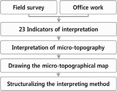
3.2 ņŚ░ĻĄ¼ļīĆņāüņ¦Ć
ņŚ░ĻĄ¼ļīĆņāüņ¦ĆļŖö 2011ļģä 7ņøö 27ņØ╝ ĒåĀņé¼ņ×¼ĒĢ┤Ļ░Ć ļ░£ņāØĒĢ£ ņä£ņÜĖ ņÜ░ļ®┤ņé░ ņØ╝ņøÉņØ┤ļŗż. ņ×¼ĒĢ┤ ļŗ╣ņŗ£ ņÜ░ļ®┤ņé░ ņØ╝ņøÉņŚÉņä£ļŖö ņØĖļ¬ģĒö╝ĒĢ┤ 67ļ¬ģ, ņ×¼ņé░Ēö╝ĒĢ┤ ņŻ╝ĒāØĒīīņåÉ 11ņäĖļīĆ, ņ╣©ņłś 3,687Ļ▒┤ ļō▒ņØ┤ ļ░£ņāØĒĢśņśĆļŗż(Yoo et al., 2014).
ņØ┤ ņŚ░ĻĄ¼ņŚÉņä£ļŖö ĒĢŁĻ│Ąņé¼ņ¦ä ņĀüņÜ®ņØś ņĀüĒĢ®ņä▒ ĒīÉņĀĢņØä ņ£äĒĢ┤ ĻĖ░ņĪ┤ņØś ņ×¼ĒĢ┤ņĪ░ņé¼ļ│┤Ļ│Āņä£ ļō▒ņØä ĒÖ£ņÜ®ĒĢśņŚ¼ 1ņ░© ĒīÉļÅģ Ļ░£ņåīņłśļź╝ Ļ▓░ņĀĢĒĢ£ Ēøä, ĒśäņןņĪ░ņé¼ņÖĆ ĒĢŁĻ│Ąņé¼ņ¦äņØä ĒåĄĒĢ┤ Ļ░£ņåīņłśļź╝ ĒÖĢņĀĢĒĢśņśĆļŗż. ĻĘĖ Ļ▓░Ļ│╝ ņÜ░ļ®┤ņé░ ņØ╝ņøÉņŚÉļŖö 41Ļ░£ņåīņØś ņåīņ£ĀņŚŁņŚÉ Ļ▒Ėņ│É 126Ļ░£ņåīņØś ļČĢĻ┤┤ņ¦ĆĻ░Ć ņŗØļ│äļÉśņ¢┤ ņåīņ£ĀņŚŁļŗ╣ ĒÅēĻĘĀ 3.1Ļ░£ņåī ņĀĢļÅäņØś ņé¼ļ®┤ļČĢĻ┤┤Ļ░Ć ļ░£ņāØļÉ£ Ļ▓āņ£╝ļĪ£ ĒīīņĢģļÉśņŚłļŗż.
3.3 ļ»Ėņ¦ĆĒśĢ ĒīÉļÅģņ×ÉļŻī
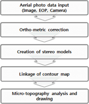
ļ»Ėņ¦ĆĒśĢ ĒīÉļÅģņØä ņ£äĒĢ£ ņŚ░ĻĄ¼ ņ×ÉļŻīļŖö ŌæĀ ĒĢŁĻ│Ąņé¼ņ¦ä, ŌæĪ 1:5000ņØś ņłśņ╣śņ¦ĆĒśĢļÅä ļ░Å Ōæó 5├Ś5 m Ļ▓®ņ×É Ēü¼ĻĖ░ņØś ņłśņ╣śĒæ£Ļ│Āļ¬©ļŹĖ(DEM)ņØ┤ļ®░, ĒīÉļÅģ ļ░Å ļÅäĒÖöļŖö ņłśņ╣śļÅäĒÖöĻĖ░(DPS Master ver. 1.5)ļź╝ ĒÖ£ņÜ®ĒĢśņśĆļŗż. ĒĢŁĻ│Ąņé¼ņ¦ä ņ×ÉļŻīļŖö 2011ļģä ņÜ░ļ®┤ņé░ ĒåĀņé¼ņ×¼ĒĢ┤ ļ░£ņāØ ņØ┤ņĀäĻ│╝ ņØ┤Ēøä ņ×ÉļŻīļź╝ ĒÖĢļ│┤ĒĢśņŚ¼, Ļ░üĻ░ü ņé¼ļ®┤ļČĢĻ┤┤ ļ░£ņāØņØś ņĀäņĪ░Ēśäņāü(ņĀä)Ļ│╝ ĻĘĖņŚÉ ļö░ļźĖ ļČĢĻ┤┤ņŚ¼ļČĆ(Ēøä)ļź╝ ļ╣äĻĄÉĒĢĀ ņłś ņ׳ļÅäļĪØ ĒĢśņśĆļŗż. ņ×¼ĒĢ┤ļ░£ņāØ ņĀäņŚÉ ņ┤¼ņśüļÉ£ ĒĢŁĻ│Ąņé¼ņ¦äņØĆ ADS Line ļ░®ņŗØņØś ĒĢŁĻ│Ąņé¼ņ¦ä 78ļÅäņŚĮņ£╝ļĪ£ ņŖżĒģīļĀłņśż ļ¬©ļŹĖņØä ĒśĢņä▒ĒĢśņśĆĻ│Ā, ļ░£ņāØ ĒøäņŚÉ ņ┤¼ņśüļÉ£ ĒĢŁĻ│Ąņé¼ņ¦äņØĆ CCD Frame ļ░®ņŗØņØś ĒĢŁĻ│Ąņé¼ņ¦ä 24ļ¦żļĪ£ ņŖżĒģīļĀłņśż ļ¬©ļŹĖņØä ĒśĢņä▒ĒĢśņśĆļŗż.
4. ĒīÉļÅģņ¦ĆĒæ£ņØś ņäĀņĀĢĻ│╝ ņĀüņÜ®
4.1 Ļ┤ĆļĀ©ņŚ░ĻĄ¼ ņé¼ļĪĆņĪ░ņé¼
ņé░ņ¦Ć ĒåĀņé¼ņ×¼ĒĢ┤ Ļ┤ĆļĀ© ĒīÉļÅģņ¦ĆĒæ£ ņäĀņĀĢņØä ņ£äĒĢ┤ ĻĄŁļé┤ņÖĖ Ļ┤ĆļĀ© ņé¼ļĪĆļź╝ ņĪ░ņé¼ĒĢśņśĆļŗż. ĻĘĖ Ļ▓░Ļ│╝ ņØ╝ļ│ĖņØś Ļ▓ĮņÜ░ ņ¦ĆĒśĢĒĢÖ(Suzuki, 1997;Tamura, 1974), ņ¦ĆĒśĢĻ│ĄĒĢÖ(Imamura, 2012) ļ░Å ļ»Ėņ¦ĆĒśĢĒīÉļÅģ(Ooishi, 2014)ņØś ņäĀĒ¢ēņŚ░ĻĄ¼ņ×ÉļŻīĻ░Ć ĒÖĢņØĖļÉśņŚłļŗż. ļśÉĒĢ£ ņØ╝ļ│ĖņØĆ ņ¦ĆĒśĢ(Ļ│Ą)ĒĢÖ ņ¦ĆņŗØĻ│╝ ĻĖ░ļ▓ĢņØ┤ ņ▓┤Ļ│äĒÖöļÉśņ¢┤ ņ׳ņŚłņ£╝ļ®░, ļéśņĢäĻ░Ć ņ¦ĆĒśĢļČäļźśļÅä, ĒåĀņ¦ĆņĪ░Ļ▒┤ļÅä ļō▒ņØś Ļ┤æņŚŁļ»Ėņ¦ĆĒśĢļČäļźśļÅäņÖĆ ņé¼ļ░®ĻĖ░ļ░śļÅä, ļ»Ėņ¦ĆĒśĢļČäļźśļÅä ļō▒ņØś ņāüņäĖļ»Ėņ¦ĆĒśĢļČäļźśļÅäļź╝ ņĀ£ņ×æĒĢśĻ│Ā ņ׳ņŚłļŗż(Okimura and Miyagi, 1991; Fukasawa et al., 2011; Iida et al., 2006; Hagiwara and Nobata, 2015). ĻĄŁļé┤ņØś Ļ▓ĮņÜ░ņŚÉļŖö ņé¼ļ░®ņ¦Ć ļ░Å ĒåĀņé¼ņ×¼ĒĢ┤ņ¦Ć ņĪ░ņé¼ņŗ£ ļ»Ėņ¦ĆĒśĢ ļČäņäØ Ļ░£ļģÉņØ┤ ļČĆļČäņĀüņ£╝ļĪ£ ņĀüņÜ®ļÉśņ¢┤ņ¦ĆĻ│Ā ņ׳ļŖö Ļ▓āņ£╝ļĪ£ ņĢīļĀżņĀĖ ņ׳ļŗż(Kim, 1995).
4.2 ņäĀĒ¢ēņŚ░ĻĄ¼ņØś ĒīÉļÅģņØĖņ×É ņČöņČ£
ņÜ░ļ”¼ļéśļØ╝ ņé░ņ¦ĆņŚÉ ņĀüņÜ® Ļ░ĆļŖźĒĢ£ ņ¦ĆĒæ£ļź╝ ĒÖĢņĀĢĒĢśĻĖ░ ņ£äĒĢ┤ ņØ╝ļ│ĖņØś ņäĀĒ¢ēņŚ░ĻĄ¼ņé¼ļĪĆņÖĆ ļ»Ėņ¦ĆĒśĢļČäļźśļÅäļĪ£ ĒīÉļÅģņ¦ĆĒæ£ļź╝ ņČöņČ£ĒĢśņśĆļŗż. ņØ╝ļ│ĖņŚÉņä£ ĒÖ£ņÜ®ļÉśļŖö ļ¦ÄņØĆ ļ»Ėņ¦ĆĒśĢ ņ¦ĆĒæ£ ņżæ ņ¦ĆĒśĢĒśĢņä▒ ĒŖ╣ņä▒ņØś ņ░©ņØ┤ņŚÉ ņØśĒĢ┤ ņÜ░ļ”¼ļéśļØ╝ņŚÉņä£ ļéśĒāĆļéśņ¦Ć ņĢŖļŖö ņ¦ĆĒæ£ļź╝ ņĀ£ņÖĖĒĢ£ ņ¦ĆĒæ£ĻĄ░ņØä ĻĄ¼ņä▒ĒĢśĻ│Ā, ņØ┤ļź╝ ĻĖ░ņ┤łļĪ£ ņé¼ļ░®Ļ│ĄĒĢÖ ļČäņĢ╝ņØś ņĀäļ¼ĖĻ░ĆļōżļĪ£ļČĆĒä░ ņ×Éļ¼ĖņØä ļ░øņĢä 18ņóģņØś ĒīÉļÅģņØĖņ×ÉņÖĆ 5ņóģņØś ĒĢäņłśĻ░£ļģÉ ļō▒ ņ┤Ø 23ņóģņØä ņĀĢļ”¼ĒĢśņśĆļŗż(Table 1).
Table┬Ā1
Indicators for Micro-topography Interpreting in the Prior Study
| Category | Area micro-topography classification map | Wide area micro-topography classification map | ||||||
|---|---|---|---|---|---|---|---|---|
| Micro-landform classification map | Erosion Control base map | Hazard map | Landform classification map | Land condition map | ||||
| This study | Okimura and Miyagi (1991) | Fukasawa et al. (2011) | Fukasawa et al. (2004) | Inagaki and Yanagida (2003) | Iida et al. (2006) | Hagiwara and Nobata (2015) | ||
| Total(indicator/ basic factor) | 23(18/5) | 9(5/4) | 11(9/3) | 6(5/1) | 7(5/2) | 8(7/1) | 18(13/5) | |
| Indicator | Deformed land | Scarp, Cliff, Escarpment | Terrace cliff, Scarp, Crack | Terrace scarp | Cliff, Main scarp | |||
| Bare land | ||||||||
| Collapsed site | Surface avalanche | Slipped land | collapsed site | Slipped land, Creeping land | land creep | |||
| Terrace | Plateau, Terrace | Terrace | Low┬Ęhigh Terrace | Terrace | ||||
| The foothill deposits | Colluvial slope | Colluvial slope | ||||||
| Talus | Bare rock, Talus | Talus | Talus | Talus | ||||
| Debris Fan | Debris Fan | Debris Fan | Debris Fan | Collapsed Site | The foothill deposits | |||
| Terrace surface | Deposite | Deposite | Sand Bar | |||||
| Lowland | Alluvial Fan | Alluvial Fan | ||||||
| Eroded land | Depression, Hollow | Hollow, Gully | Gully | Gully, Valley | Depression, Hollow | |||
| Slope | Convex slope | Crest | Cryoplanation Surface | Hilly Landform | Piedmont | Slope | ||
| Concave slope | Valley slope | |||||||
| Straight slope | Piedmont | Side of Slope | ||||||
| Artificial structure | Planated land | Planated land | ||||||
| Cutting slope | Cutting slope | |||||||
| Banking slope | Landfill | |||||||
| Under earthwork land | Under earthwork land | |||||||
| Artificial structure | Simple dam, Concrete channel | Small check dam | Turning line of slope | |||||
| Basic factor | Break of slope | Convex knick line | Convex knick line | Convex knick line | Break of slope | Break of slope | ||
| Concave knick line | Concave knick line | Concave knick line | ||||||
| Torrential river and bed | Torrential river | Channel way | Channel way | Stream | ||||
| Depression site | Pool, Pond | Lake, Pool | Marshy land | |||||
| Valley bottom | Valley bottom | Stram marks | ||||||
4.3 ĒīÉļÅģņØĖņ×ÉņØś ņĀüņĀłņä▒ Ļ▓ĆĒåĀ ļ░Å ĒīÉļÅģņ¦ĆĒæ£ņØś ĒÖĢņĀĢ
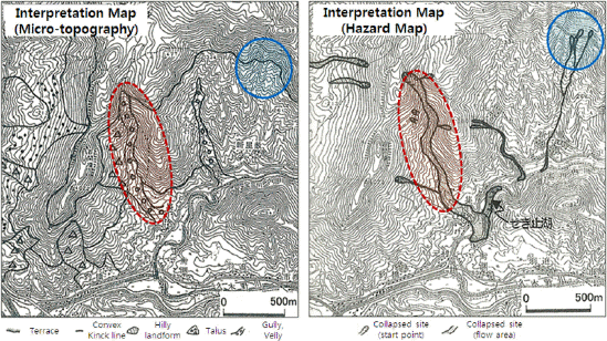
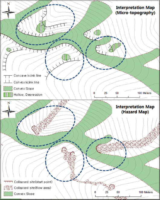
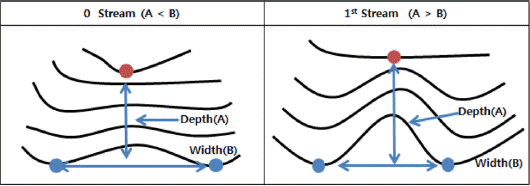
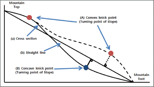
Inagaki and Yanagida(2003)ļŖö ĒåĀņäØļźśņÖĆ Ļ┤ĆļĀ©ļÉ£ ņ¦ĆĒśĢņ¦ĆĒæ£ļź╝ ņāüņäĖļ»Ėņ¦ĆĒśĢļČäļźśļÅäņÖĆ ĒåĀņäØļźśņ×¼ĒĢ┤ļÅä ļō▒ņŚÉņä£ ĒÖĢņØĖĒĢśņŚ¼ ņĀüņĀłņä▒ņØä ņĀÉĒåĀĒĢśņśĆļŗż. ņØ┤ļĢī ĒåĀņäØļźśļŖö ņĢĀņČö(Talus)Ļ░Ć ņĪ┤ņ×¼ĒĢśļŖö ņ¦ĆĒśĢ ļ░Å ņ▓£ĻĖēņäĀņØ┤ ņ£äņ╣śĒĢśļŖö ņÜöņ¦Ć(Depression), ņÖĆņ¦Ć(Hollw)ļō▒ņŚÉņä£ ĒåĀņäØļźśĻ░Ć ļ░£ņāØĒĢśņśĆļŗż(Fig. 2). ļö░ļØ╝ņä£ ņØ┤ ņŚ░ĻĄ¼ļŖö ĻĄŁņÖĖņé¼ļĪĆļź╝ ĻĖ░ņ┤łļĪ£ ņÜ░ļ®┤ņé░ņØś ĒåĀņäØļźś Ēö╝ĒĢ┤ņ¦ĆņØś ņāüņäĖļ»Ėņ¦ĆĒśĢļČäļźśļÅäņÖĆ ņé░ņé¼Ēā£ņ×¼ĒĢ┤ļÅäļź╝ ņŗ£ļ▓ö ņĀ£ņ×æĒĢśņŚ¼ ĒīÉļÅģņØĖņ×É(Table 1)ņÖĆņØś Ļ┤ĆļĀ©ņä▒ņØä ĒÖĢņØĖĒĢśņśĆļŗż(Fig. 3). ĻĘĖ Ļ▓░Ļ│╝ ĒåĀņäØļźśĻ░Ć ņŻ╝ļĪ£ ļ░£ņāØĒĢ£ ņ¦ĆĒśĢņØĆ ņ▓£ĻĖēņäĀ(Convex knick Line) ņĢäļל ņ£äņ╣śĒĢ£ ņÖĆņ¦ĆļĪ£ņä£ ņ¦ĆĒæ£ņØś ņĀüņÜ®ņØ┤ ņ£ĀĒÜ©ĒĢ£ Ļ▓āņ£╝ļĪ£ ĒīÉļŗ©ļÉśņŚłĻ│Ā, 18ņóģņØś ĒīÉļÅģņØĖņ×ÉņÖĆ 5ņóģņØś ĒĢäņłśĻ░£ļģÉņØä ĒżĒĢ©ĒĢśļŖö ņ┤Ø 23ņóģņØś ĒīÉļÅģņ¦ĆĒæ£ļź╝ ĒÖĢņĀĢĒĢśĻ│Ā ņāüņäĖņĪ░Ļ▒┤ņØä ņĀĢļ”¼ĒĢśņśĆļŗż(Table 2).
Table┬Ā2
Twenty-three Types of Micro-topography Interpreting Indicators
5. ĒīÉļÅģ ĒÖśĻ▓Į ļ░Å ņĀłņ░©
5.1 ĒīÉļÅģĒÖśĻ▓ĮņØś ĻĄ¼ņČĢ
ņØ╝ļ░śņĀüņ£╝ļĪ£ ņ¦ĆĒśĢĒīÉļÅģņØĆ ļīĆņāüņ¦ĆņØś ĒĢŁĻ│Ąņé¼ņ¦ä, ņŖżĒģīļĀłņśż ļ¬©ļŹĖ ļ░Å ņ¦ĆĒśĢļÅä, DEM ļō▒ņØś ņ×ÉļŻīļź╝ ĒÖ£ņÜ®ĒĢśņŚ¼ ņ¦äĒ¢ēĒĢ£ļŗż. ņØ┤ ņżæņŚÉņä£ ņŖżĒģīļĀłņśż ļ¬©ļŹĖņØĆ ĒĢŁĻ│Ąņé¼ņ¦äņØś ņżæļ│ĄļÅäļź╝ ņØ┤ņÜ®ĒĢśņŚ¼ ĒśĢņä▒ĒĢśļ®░, ņ×ģņ▓┤ņŗ£ņŚÉ ņØśĒĢ┤ ņ×ģņ▓┤Ļ░ÉņØä ņ¢╗Ļ▓ī ļÉ£ļŗż. ņØ┤ ļģ╝ļ¼ĖņŚÉņä£ļŖö ņØ┤ļ¤¼ĒĢ£ ņŖżĒģīļĀłņśż ļ¬©ļŹĖņØä ņØ┤ņÜ®ĒĢśņŚ¼ ĒīÉļÅģĒÖśĻ▓ĮņØä ĻĄ¼ņČĢĒĢśņśĆņ£╝ļ®░, ĻĘĖ ņĀłņ░©ļŖöFig. 4ņÖĆ Ļ░ÖņØ┤ ĒĢŁĻ│Ąņé¼ņ¦ä ļ░Å ļŹ░ņØ┤Ēä░ ņ×ģļĀź, ņĀĢņé¼ļ│┤ņĀĢ, ņŖżĒģīļĀłņśżļ¬©ļŹĖ ĒśĢņä▒, ņ¦ĆĒśĢļÅäņÖĆņØś ņżæņ▓®, ļÅäĒÖö ņł£ņ£╝ļĪ£ ņ¦äĒ¢ēļÉśņŚłļŗż.
5.2 ņ¦ĆĒśĢĒīÉļÅģņŚÉ ņØ┤ņÜ®ļÉśļŖö ņŻ╝ņÜö ņÜöņåī
ņØ╝ļ░śņĀüņ£╝ļĪ£ ņ×ÉņøÉ ļ░Å ĒÖśĻ▓Į ļō▒ņØś ņĪ░ņé¼ņŚÉ ņØ┤ņÜ®ļÉśļŖö ņé¼ņ¦äĒīÉļÅģņØś9ņÜöņåīļŖö ņāēņĪ░(tone), ĒśĢĒā£(pattern), ņ¦łĻ░É(texture), Ēü¼ĻĖ░(size), ĒśĢņāü(shape), ņØīņśü(shadow)ņØś 6Ļ░£ ĻĖ░ļ│ĖņÜöņåīņÖĆ, Ļ│╝Ļ│ĀĻ░É(vertical exaggeration), ņāüĒā£(situation), ņ£äņ╣ś(location)ņØś 3Ļ░£ ļ│┤ņĪ░ņÜöņåīļĪ£ ĻĄ¼ņä▒ļÉ£ļŗż(Kang et al., 1993; Kim, 1976). ņØ┤ ņŚ░ĻĄ¼ņŚÉņä£ļŖö ņØ┤ļōż 9ņÜöņåīļź╝ ĒÖ£ņÜ®ĒĢśņśĆņ£╝ļ®░, ĒŖ╣Ē׳ Ēü¼ĻĖ░, ĒśĢņāü, Ļ│╝Ļ│ĀĻ░ÉņØä ņŻ╝ļĪ£ ņĪ░ĒĢ®ĒĢśņŚ¼ ļ»Ėņ¦ĆĒśĢ ĒīÉļÅģņØä ņŗżņŗ£ĒĢśņśĆļŗż.
5.3 ĒīÉļÅģņØś ņĀłņ░©
ņ¦ĆĒśĢĒīÉļÅģņØĆ ņŚ░ĻĄ¼ļīĆņāüņ¦Ć ņĀäņ▓┤ņŚÉ ļīĆĒĢ£ Ļ░£ĒÖ®ĒīÉļÅģĻ│╝ ņāüņäĖĒīÉļÅģņ£╝ļĪ£ ĻĄ¼ļČäļÉ£ļŗż. ļ©╝ņĀĆ Ļ░£ĒÖ®ĒīÉļÅģņŚÉ ņØśĒĢ┤ ņÜ░ļ®┤ņé░ ņØ╝ņøÉņØś Ēæ£Ļ│Ā, ņ¦ĆņäĖ, ļŖźņäĀĻ│╝ Ļ│ĪņØś ņ£äņ╣śņÖĆ ļ░£ļŗ¼ ļ░®Ē¢źņØä ĒīīņĢģĒĢśĻ│Ā ņØ┤ļź╝ ĻĖ░ļ░śņ£╝ļĪ£ ņåīņ£ĀņŚŁņØä ĻĄ¼ļČäĒĢśņśĆļŗż. ļŗżņØīņØĆ ņåīņ£ĀņŚŁ ļŗ©ņ£äņØś ņ╣©ņŗØņ¦ĆĒśĢ, ļ│ĆĒśĢņ¦ĆĒśĢ, ņØĖĻ│Ąņ¦Ć ļō▒ ĒåĀņé¼ņ×¼ĒĢ┤ Ļ┤ĆļĀ©ņ¦ĆĒæ£ļź╝ ĒīÉļÅģĒĢśņśĆĻ│Ā, ņåīņ£ĀņŚŁņØä ņé░ņ¦Ćņé¼ļ®┤ņØä ņĀ£ņÖĖĒĢ£ ĒīÉļÅģņØĖņ×ÉņØś ĒīÉļÅģ ĻĖ░ļ│Ėļŗ©ņ£äļĪ£ ņäżņĀĢĒĢśņśĆļŗż.
ņ¦ĆĒśĢ ĒīÉļÅģņØä ņŗżņŗ£ĒĢ£ Ļ▓░Ļ│╝ 18ņóģņØś ĒīÉļÅģņØĖņ×É 5ņóģņØś ĒĢäņłśĻ░£ļģÉ ņżæ 9ņóģņØś ĒīÉļÅģņØĖņ×ÉĻ░Ć ĒīÉļÅģļÉśņŚłĻ│Ā, 4ņóģņØś ĒĢäņłśĻ░£ļģÉņØ┤ ĒÖĢņØĖļÉśņŚłļŗż(Table 3).
Table┬Ā3
Results of Micro-topography Interpretation
5.3.1 ņé░ņ¦Ćņé¼ļ®┤ņØś ĒīÉļÅģ
ņé░ņ¦Ćņé¼ļ®┤ņØś ĒīÉļÅģņØĆ ļŖźņäĀ, Ļ│©ņ¦£ĻĖ░, ņ¦üņäĀĒśĢ ņé¼ļ®┤ ņł£ņ£╝ļĪ£ ņ¦äĒ¢ēĒĢśņśĆļŗż. ļŖźņäĀĒśĢņé¼ļ®┤ņØĆ ņé░ņĀĢļČĆņŚÉņä£ ņé░ļ¦źņØä ļö░ļØ╝ ņĢäļ×½ļ░®Ē¢źņ£╝ļĪ£ ĒīÉļÅģĒĢśņśĆņ£╝ļ®░, Ļ│©ņ¦£ĻĖ░ĒśĢ ņé¼ļ®┤ņØĆ ņ£ĀņŚŁņØś ņŗ£ņ×æ ĻĖ░ņżĆņĀÉņ£╝ļĪ£ļČĆĒä░ ņé░ņĀĢļČĆ ļ░®Ē¢źņ£╝ļĪ£ ĒīÉļÅģĒĢśņśĆļŗż(Fig. 5). ņ¦üņäĀĒśĢ ņé¼ļ®┤ņØĆ ļŖźņäĀĒśĢņé¼ļ®┤Ļ│╝ Ļ│©ņ¦£ĻĖ░ĒśĢņé¼ļ®┤ ņé¼ņØ┤ņŚÉ ņ£äņ╣śĒĢśļéś, ņÜ░ļ®┤ņé░ņØä ļīĆņāüņ£╝ļĪ£ļŖö Ļ▒░ņØś ĒīÉļÅģļÉśņ¦Ć ņĢŖņĢśļŗż.

ņé░ņ¦Ćņé¼ļ®┤ņØś ĒīÉļÅģņŗ£ ņŻ╝ļĪ£ Ļ│╝Ļ│ĀĻ░É, ņāüĒā£, ņ£äņ╣ś ļō▒ņØś ņÜöņåīļź╝ ĒÖ£ņÜ®ĒĢśņśĆņ£╝ļ®░, ļŖźņäĀĒśĢņé¼ļ®┤Ļ│╝ Ļ│©ņ¦£ĻĖ░ĒśĢ ņé¼ļ®┤ņØś Ļ▓ĮĻ│äļŖö ļŖźņäĀņŚÉņä£ Ļ│©ņ¦£ĻĖ░ļĪ£ ļ│ĆĒÖśļÉśļŖö ņ¦ĆņĀÉņØś Ļ▓Įņé¼ļ│ĆĒÖśņäĀņ£╝ļĪ£ Ļ▓░ņĀĢĒĢśņŚ¼ ĒīÉļÅģĒĢśņśĆļŗż.
5.3.2 ņ╣©ņŗØņ¦ĆĒśĢ, ļ│ĆĒśĢņ¦Ć, ņØĖĻ│Ąņ¦ĆĒśĢņØś ĒīÉļÅģ
ņÜ░ļ®┤ņé░ņØä ļīĆņāüņ£╝ļĪ£ ņ╣©ņŗØņ¦ĆĒśĢ, ļ│ĆĒśĢņ¦Ć, ņØĖĻ│Ąņ¦ĆĒśĢ ļō▒ņØä ĒīÉļÅģĒĢ£ Ļ▓░Ļ│╝ ņÜöņ¦Ć ļ░Å ņÖĆņ¦Ć, ņØĖĻ│ĄĻĄ¼ņĪ░ļ¼╝, ņĀłĒåĀļ®┤, ņä▒ĒåĀļ®┤, ļČĢĻ┤┤ņ¦Ć, ĒÅēĒāäĒÖöņ¦Ć ļō▒ņØ┤ ĒīÉļÅģļÉśņŚłļŗż.
ņé░ņ¦Ćņé¼ļ®┤ņØä ņĀ£ņÖĖĒĢ£ ĒīÉļÅģ ĻĖ░ļ│Ėļŗ©ņ£äņØĖ ņåīņ£ĀņŚŁņØĆ 0ņ░©Ļ│ĪĻ│╝ 1ņ░©Ļ│Īņ£╝ļĪ£ ĻĄ¼ņä▒ļÉśņ¢┤ ņ׳ņŚłņ£╝ļ®░, ņØ┤ļĢī ņÖĆņ¦Ć ļ░Å ņÜöņ¦ĆļŖö 0ņ░©Ļ│Ī ļśÉļŖö1ņ░©Ļ│ĪņØś ņĀæĒĢ®ņ¦ĆņĀÉņŚÉ ņ£äņ╣śĒĢśņśĆļŗż. ņÖĆņ¦ĆņØś Ēü¼ĻĖ░ļŖö ĒÅēĻĘĀņĀüņ£╝ļĪ£ 120 m2ļĪ£ņä£ 1/5000ņØś ņ¦ĆĒśĢļÅäņŚÉļŖö ļéśĒāĆļéśņ¦Ć ņĢŖļŖö Ļ▓ĮņÜ░Ļ░Ć ļ¦ÄņĢśĻ│Ā, ņżæņ▓®ĒÖöļ®┤ ļé┤ņŚÉņä£ Ļ│╝Ļ│ĀĻ░É, Ēü¼ĻĖ░, ņāēņĪ░ ļō▒ņ£╝ļĪ£ ĒīÉļÅģĒĢśņśĆļŗż.
ņØĖĻ│ĄĻĄ¼ņĪ░ļ¼╝ņØĆ ņé░ņ¦Ć ļé┤ ņ£äņ╣śĒĢ£ ņ×äļÅä, ļō▒ņé░ļĪ£, Ē£┤ņ¢æņŗ£ņäż ļō▒ņ£╝ļĪ£ ļéśĒāĆļé¼ņ£╝ļ®░, ņ×äļÅä ļ░Å ļō▒ņé░ļĪ£ļŖö ņ┤Ø 9,894 m, Ē£┤ņ¢æņŗ£ņäż ļ░Å ĻĖ░ĒāĆ ņŗ£ņäżņØĆ 19Ļ░£ņåīļĪ£ ĒÅēĻĘĀ 204 m2ņØ┤ņŚłļŗż. ņ×äļÅäļŖö ņ¦ĆĒśĢļÅäņāüņŚÉ ļÅäļĪ£ņØś ĒśĢĒā£ļĪ£ ļéśĒāĆļé¼ņ¦Ćļ¦ī, ļō▒ņé░ļĪ£ņÖĆ Ē£┤ņ¢æņŗ£ņäżņØĆ ņ¦ĆĒśĢļÅäņāüņŚÉ ļéśĒāĆļéśņ¦Ć ņĢŖņĢśļŗż. ļö░ļØ╝ņä£ ņØĖĻ│ĄĻĄ¼ņĪ░ļ¼╝ņØś ĒīÉļÅģ ļśÉĒĢ£ ņłśņ╣śļÅäĒÖöĻĖ░ļź╝ ĒÖ£ņÜ®ĒĢ£ ĒĢŁĻ│Ąņé¼ņ¦äĻ│╝ ņ¦ĆĒśĢļÅäņØś ņżæņ▓®ļČäņäØņØ┤ ĒĢäņÜöĒĢ£ Ļ▓āņ£╝ļĪ£ ĒīÉļŗ©ļÉśņŚłņ£╝ļ®░, ņŻ╝ļĪ£ ņāēņĪ░, ĒśĢĒā£, ĒśĢņāü ļō▒ņØś ņÜöņåīļĪ£ ĒīÉļÅģĒĢśņśĆļŗż.
ņĀłĒåĀņ¦Ć ļ░Å ņä▒ĒåĀņ¦ĆļŖö ņŻ╝ļĪ£ ņØĖĻ│ĄĻĄ¼ņĪ░ļ¼╝ ĒĢśļČĆ ļśÉļŖö ņāüļČĆņŚÉņä£ ĒīÉļÅģļÉśņŚłļŗż. ņĀłĒåĀņ¦ĆļŖö 2Ļ░£ņåīĻ░Ć ĒīÉļÅģļÉśņŚłņ£╝ļ®░ ĒÅēĻĘĀ ļ®┤ņĀüņØ┤ 13,612m2ņØ┤ņŚłĻ│Ā, ņä▒ĒåĀņ¦ĆļŖö ņ┤Ø 11Ļ░£ņåīļĪ£ņä£ ĒÅēĻĘĀņĀüņ£╝ļĪ£ 3,685m2ņØ┤ņŚłļŗż. ņĀłĒåĀņ¦Ć ļ░Å ņä▒ĒåĀņ¦ĆļŖö ņØĖĻ│ĄĻĄ¼ņĪ░ļ¼╝ ĒĢśļČĆ ļśÉļŖö ņāüļČĆņŚÉ ĻĖēĻ▓Įņé¼ņØś ĒśĢĒā£ļĪ£ ļéśĒāĆļé¼ļŗż. ĒīÉļÅģņØĆ Ļ│╝Ļ│ĀĻ░É, ņāüĒā£, ņ£äņ╣ś ļō▒ņØś ņÜöņåīļź╝ ĒÖ£ņÜ®ĒĢśņśĆļŗż.
ĒÅēĒāäĒÖöņ¦ĆļŖö ņé░ņ¦Ć ļé┤ ļ¼śņ¦Ć ļśÉļŖö Ļ▓Įņ×æņ¦Ć, ņāØĒā£Ļ│ĄņøÉ ļō▒ņØ┤ ĒīÉļÅģļÉśņŚłņ£╝ļ®░, ņ┤Ø 82Ļ░£ņåī ĒÅēĻĘĀļ®┤ņĀü 535 m2ļĪ£ ļéśĒāĆļé¼ļŗż. ĒÅēĒāäĒÖöņ¦ĆļŖö ņ¦ĆĒśĢļÅäļ¦īņØä ĒÖ£ņÜ®ĒĢśņŚ¼ ĒīÉļÅģņØ┤ Ļ░ĆļŖźĒĢśņśĆņ£╝ļéś, ņĀĢĒÖĢĒĢ£ ļ®┤ņĀüĻ│╝ ĒśĢĒā£ļź╝ ņĢīĻĖ░ ņ£äĒĢ┤ņä£ļŖö ņé¼ņ¦äĻ│╝ņØś ņżæņ▓®ĒīÉļÅģņØ┤ ĒĢäņÜöĒĢśņśĆļŗż.
ņłśĒĢ┤Ļ░Ć ļ░£ņāØĒĢśĻĖ░ ņĀä ļČĢĻ┤┤ņ¦ĆļŖö 20Ļ░£ņåīĻ░Ć ĒīÉļÅģļÉśņŚłņ£╝ļ®░, ĒÅēĻĘĀ ļ®┤ņĀüņØĆ ļŗżļźĖ ĒīÉļÅģņØĖņ×ÉņÖĆ ļ╣äĻĄÉĒĢśņśĆņØä ļĢī Ļ░Ćņן ņ×æņØĆ ļ®┤ņĀüņØĖ 45 m2ņØä ļ│┤ņśĆļŗż. ļö░ļØ╝ņä£ ļČĢĻ┤┤ņ¦Ć ĒīÉļÅģņØĆ ņżæņ▓®ĒīÉļÅģņØ┤ ĒĢäņÜöĒĢśļ®░, ņŻ╝ļ│ĆĻ│╝ņØś ņāēĻ│╝ ĒśĢĒā£ļź╝ ļ╣äĻĄÉĒĢśņŚ¼ ĒīÉļÅģĒĢśņśĆļŗż.
5.3.3 ĒĢäņłśĻ░£ļģÉņØś ĒīÉļÅģ
ĒĢäņłśĻ░£ļģÉņØś ĒīÉļÅģĻ▓░Ļ│╝ ņåīĒāØņ¦Ć, Ļ│äļźś, ņ▓£ĻĖēņäĀĻ│╝ ņ▓£ņÖäņäĀņØ┤ ĒīÉļÅģļÉśņŚłļŗż. ņåīĒāØņ¦ĆļŖö ņÜ░ļ®┤ņé░ ņāØĒā£Ļ│ĄņøÉņØś ņĀĆņłśņ¦ĆĻ░Ć ĒīÉļÅģļÉśņŚłņ£╝ļ®░ ļ®┤ņĀüņØĆ 2,576 mņØ┤ņŚłļŗż.
Ļ│äļźś ĒīÉņĀĢņØĆ ĻĘĖļ”╝ 7Ļ│╝ Ļ░ÖņØĆ Ļ░£ļģÉņ£╝ļĪ£ ĒīÉļÅģĒĢśņśĆļŗż. Ļ│äļźśņØś 0ņ░©Ļ│ĪĻ│╝ 1ņ░©Ļ│ĪņØś Ļ▓░ņĀĢņØĆ Ļ╣ŖņØ┤(A)ņÖĆ ļäłļ╣ä(B)ļź╝ ļ╣äĻĄÉĒĢśņŚ¼ ņäżņĀĢĒĢ£ļŗż. AĻ░Ć Bļ│┤ļŗż ĻĖĖļ®┤ 1ņ░©Ļ│Ī, ņ¦¦ņ£╝ļ®┤ 0ņ░©Ļ│Īņ£╝ļĪ£ ĻĄ¼ļČäĒĢ£ļŗż(National Institute for Land and Infrastructure Management, 2007).
ņ▓£ĻĖēņäĀ, ņ▓£ņÖäņäĀņØś ĒīÉļÅģņØĆ ĻĘĖļ”╝ 8Ļ│╝ Ļ░ÖņØĆ Ļ░£ļģÉņ£╝ļĪ£ ĒīÉļÅģĒĢśņśĆļŗż. ņÜ░ņäĀ ņ£ĀņŚŁ ļé┤ Ļ│äļźśļź╝ ļö░ļØ╝ ĒÜĪļŗ©ļ®┤(a) ņäżņĀĢĒĢ£ļŗż. ĒÜĪļŗ©ļ®┤(a)Ļ░Ć ĻĘĖļĀżņ¦Ćļ®┤, Ļ│äļźśņØś ņĄ£ņāüļČĆņÖĆ ņĄ£ĒĢśļČĆļź╝ ņØ┤ņØĆ ņäĀ(b)ļź╝ ĻĘĖļ”░ļŗż. ņØ┤ ļĢī ņäĀ(b)ņŚÉņä£ ņäĀ(a)ļĪ£ ņ¦üĻĄÉĒĢśļŖö ņ¦ĆņĀÉņØä ņ░ŠņĢśņØä ļĢī ņ¢æņØś Ļ░ÆņØä ļéśĒāĆļé┤ļŖö ņĄ£Ļ│ĀņĀÉņØĆ ņ▓£ĻĖēņĀÉ(A), ņØīņØś Ļ░ÆņØä ļéśĒāĆļé┤ļŖö ņĄ£Ļ│ĀņĀÉņØĆ ņ▓£ņÖäņĀÉ(B)ņØ┤ ļÉ£ļŗż. ņ▓£ĻĖēņäĀĻ│╝ ņ▓£ņÖäņäĀņØĆ ņ▓£ĻĖēņĀÉĻ│╝ ņ▓£ņÖäņĀÉņØä Ļ░üĻ░ü ņØ┤ņØĆ ņĀÉņØ┤ ļÉ£ļŗż.
ĒĢäņłśĻ░£ļģÉņØś ĒīÉļÅģņØĆ ņ¦ĆĒśĢļÅäļ¦ī ĒÖ£ņÜ®ĒĢśņŚ¼ ĒīÉļÅģņØ┤ Ļ░ĆļŖźĒĢśņśĆņ¦Ćļ¦ī, ņżæņ▓®ĒÖöļ®┤ ļé┤ņŚÉņä£ ņŗżņĀ£ ņ¦ĆĒśĢĻ│╝ ļ╣äĻĄÉĒĢśņŚ¼ ĒīÉļÅģņØś ņĀĢļ░ĆļÅäļź╝ ļåÆņŚ¼ņŻ╝ņŚłļŗż.
6. ĻĖ░ĒśĖĒÖö ļ░Å ļÅäļ®┤ņĀ£ņ×æ
6.1 ĒīÉļÅģņØĖņ×ÉņØś ĻĖ░ĒśĖĒÖö
ĒīÉļÅģņØĖņ×Éļź╝ ņĀÉ┬ĘņäĀ┬Ęļ®┤ņ£╝ļĪ£ ĻĖ░ĒśĖĒÖöĒĢśņŚ¼ ļÅäĒÖöĒĢśļŖö Ļ▓āņØĆ ĒīÉļÅģņØĖņ×Éļź╝ ĒÖ£ņÜ®ĒĢśĻ│Ā ļČäņäØĒĢśĻĖ░ ņ£äĒĢ┤ ļ¦żņÜ░ ņżæņÜöĒĢ£ ņĀłņ░©ņØ┤ļŗż. ĒīÉļÅģņØĖņ×ÉņØś ĻĖ░ĒśĖĒÖöļŖö ĒīÉļÅģņØĖņ×ÉņØś ĒŖ╣ņ¦ĢņØä ņāüņāüĒĢĀ ņłś ņ׳ļÅäļĪØ Ļ│ĀņĢłĒĢśļŖö Ļ▓āņØ┤ ņØ╝ļ░śņĀüņØ┤ļ®░ ņØ┤ĒĢ┤ņÖĆ ņŗØļ│äņØ┤ ņēĮĻ│Ā ĒśĢĒā£Ļ░Ć ļŗ©ņł£ĒĢśĻ│Ā ļČäļ¬ģĒĢ┤ņĢ╝ĒĢ£ļŗż(Beom. 2013). ņ¦ĆĒśĢņÜöņåīņØś ĻĖ░ĒśĖĒÖöņŚÉ Ļ┤ĆļĀ©ļÉ£ ņäĀĒ¢ēņŚ░ĻĄ¼ļŖö Kim et al.(2014)ņŚÉ ņØśĒĢ┤ ņĀ£ņŗ£ļÉśņŚłļŗż. ņäĀĒ¢ēņŚ░ĻĄ¼ļŖö ņé░ņ¦ĆņÖĆ Ļ┤ĆļĀ©ļÉ£ ņ¦ĆĒśĢņÜöņåīļź╝ ņĀÉ, ņäĀ, ļ®┤ņ£╝ļĪ£ ĻĄ¼ļČäĒĢśņŚ¼ ļÅäļ®┤ĒÖöĒĢśņśĆļŗż. ņäĀĒ¢ēņŚ░ĻĄ¼ņŚÉņä£ ĒīÉļÅģņ¦ĆĒæ£ņØś ĻĖ░ĒśĖļź╝ ĒÖĢņØĖĒĢ£ Ļ▓░Ļ│╝ ņÖĆņ¦Ć, ņśżļ¬®ņé¼ļ®┤, ļ│╝ļĪØņé¼ļ®┤, ĒĢśņ▓£ ļō▒ņØä ĒÖĢņØĖĒĢĀ ņłś ņ׳ņŚłļŗż. ņäĀĒ¢ēņŚ░ĻĄ¼ņŚÉņä£ļŖö ņØ┤ ĒīÉļÅģņ¦ĆĒæ£ļź╝ ņĀÉ ļśÉļŖö ņäĀņ£╝ļĪ£ Ēæ£ĻĖ░ĒĢśņśĆņ£╝ļéś, ņØ┤ ņŚ░ĻĄ¼ņŚÉņä£ļŖö ļ®┤ņĀüņé░ņČ£Ļ│╝ ĒśĢĒā£ņØś ĒÖĢņØĖņØä ņ£äĒĢ┤ Ļ▓Įņé¼ļ│ĆĒÖśņäĀĻ│╝ ņłśĻ│äļź╝ ņĀ£ņÖĖĒĢ£ ĒīÉļÅģņ¦ĆĒæ£ļź╝ ļ®┤ņØś ĒśĢĒā£ļĪ£ ņĀ£ņŗ£ĒĢśņśĆļŗż(Table 4).
Table┬Ā4
Symbol of Micro-topography


6.2 Ļ┤Ćļ”¼ļÅäļ®┤ņØś ņĀ£ņ×æ ļ░Å ĒÖ£ņÜ®
Ļ┤Ćļ”¼ļÅäļ®┤ņØĆ ņłśņ╣śļÅäĒÖöĻĖ░ņŚÉ ņŚ░ļÅÖļÉ£ CAD ĒöäļĪ£ĻĘĖļשņØä ĒÖ£ņÜ®ĒĢśņŚ¼ ņĀ£ņ×æĒĢśņśĆļŗż. ļśÉĒĢ£ Ļ┤Ćļ”¼ļÅäļ®┤ņØś ĻĖ░ĒśĖļŖö 6.1 ĒīÉļÅģņØĖņ×ÉņØś ĻĖ░ĒśĖĒÖöņŚÉņä£ ņĀ£ņŗ£ļÉ£ ĻĖ░ĒśĖļź╝ ĒÖ£ņÜ®ĒĢśņśĆņ£╝ļ®░, ĻĖ░ĒśĖļŖö ņłśņ╣śļÅäĒÖöĻĖ░ņØś ĻĖ░ļŖźņØä ņØ┤ņÜ®ĒĢśņŚ¼ ļ®┤ņØś ĒśĢĒā£ļĪ£ ņ¦ĆņĀĢĒĢ┤ ņŻ╝ņŚłļŗż(Fig. 9).
Fig.┬Ā6
Examples of Interpreting the Micro-topography (Eroded Land, Deformed Land and Artificial Structures)

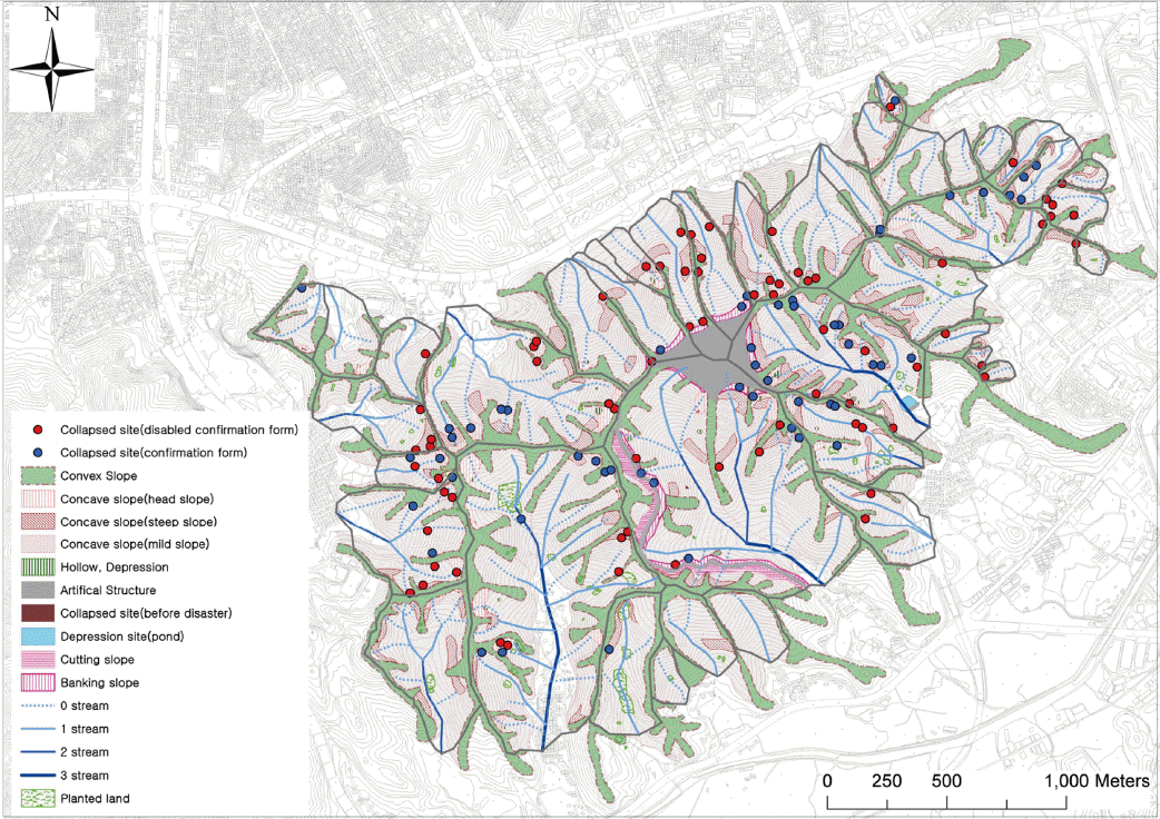
Ļ┤Ćļ”¼ļÅäļ®┤ņØĆ ļīĆņāüņ£╝ļĪ£ ĒĢśļŖö ņé░ņ¦ĆņØś ĒåĀņé¼ņ×¼ĒĢ┤ņØś Ļ░ĆļŖźņä▒ņØ┤ ņ׳ļŖö ņØĖņ×ÉļōżņØ┤ ĒżĒĢ©ļÉśņ¢┤ ņ׳ņ¢┤ ņČöĻ░ĆņĀüņØĖ ņ¦ĆĒśĢļČäņäØ ļ░Å ĒåĄĻ│äņ×æņŚģņŚÉ ĒÖ£ņÜ® ļÉĀ Ļ▓āņ£╝ļĪ£ ĒīÉļŗ©ļÉśņŚłļŗż(Fig. 10). ļśÉĒĢ£ ļīĆņāüņ£╝ļĪ£ ĒĢśļŖö ņé░ņ¦ĆņØś Ļ░£ļץņĀüņØĖ ņ¦ĆĒśĢĻ│╝ ņ¦ĆĒśĢņØĖņ×ÉļōżņØś Ļ┤ĆĻ│äļź╝ ĒīīņĢģĒĢĀ ņłś ņ׳ņ¢┤ ņé░ņ¦Ć Ļ┤Ćļ”¼ņŚÉ ĒÖ£ņÜ® ļÉĀ Ļ▓āņ£╝ļĪ£ ĒīÉļŗ©ļÉ£ļŗż.
7. Ļ▓░ļĪĀ
ņØ┤ ņŚ░ĻĄ¼ļŖö ĒĢŁĻ│Ąņé¼ņ¦äņØä ĒÖ£ņÜ®ĒĢ£ ļ»Ėņ¦ĆĒśĢļČäņäØ ĻĖ░ļ▓ĢĻ│╝ ņ▓┤Ļ│äļź╝ ņåīĻ░£ĒĢśņśĆļŗż. ļ»Ėņ¦ĆĒśĢ ļČäņäØņØĆ ĒīÉļÅģņ¦ĆĒæ£ņØś ņäĀņĀĢ, ĒīÉļÅģņØś ņĀłņ░©, ļÅäļ®┤ĒÖö ņ×æņŚģņ£╝ļĪ£ ļČäļźśĒĢśņśĆĻ│Ā, ļŗżņØīĻ│╝ Ļ░ÖņØĆ Ļ▓░Ļ│╝ļź╝ ņ¢╗ņŚłļŗż.
ĒīÉļÅģņ¦ĆĒæ£ņØś ņäĀņĀĢņØĆ ĒåĀņé¼ņ×¼ĒĢ┤ņÖĆ Ļ┤ĆļĀ© ņ׳ļŖö ļ»Ėņ¦ĆĒśĢņ¦ĆĒæ£ļź╝ ņäĀĒ¢ēņŚ░ĻĄ¼ņŚÉņä£ ņĪ░ņé¼ĒĢśņŚ¼ ņĀĢļ”¼ĒĢśņśĆļŗż. ĒīÉļÅģņ¦ĆĒæ£ļŖö 18ņóģņØś ĒīÉļÅģņØĖņ×ÉņÖĆ 5ņóģņØś ĒĢäņłśĻ░£ļģÉņØä ĒżĒĢ©ĒĢśņśĆĻ│Ā, ņāüņäĖļ»Ėņ¦ĆĒśĢļČäļźśļÅäņÖĆ ņé░ņé¼Ēā£ ņ×¼ĒĢ┤ļÅäļź╝ ņŗ£ļ▓öņĀ£ņ×æĒĢśņŚ¼ ĒīÉļÅģņØĖņ×ÉņÖĆ ĒåĀņé¼ņ×¼ĒĢ┤ņØś Ļ┤ĆļĀ©ņä▒ņØä ĒÖĢņØĖĒĢĀ ņłś ņ׳ņŚłļŗż.
ĒīÉļÅģņØś ņĀłņ░©ļŖö ĒīÉļÅģĒÖśĻ▓ĮņØś ĻĄ¼ņČĢ, ņ¦ĆĒśĢĒīÉļÅģņØś ļ░®ļ▓Ģ, ņ¦ĆĒśĢĒīÉļÅģņ£╝ļĪ£ ĻĄ¼ļČäĒĢśņŚ¼ ņåīĻ░£ĒĢśņśĆļŗż. ļ»Ėņ¦ĆĒśĢ ĒīÉļÅģņØĆ ņåīĒöäĒŖĖ ļÅäĒÖöĻĖ░ ņāüņŚÉņä£ ņŖżĒģīļĀłņśż ļ¬©ļŹĖĻ│╝ ņłśņ╣śņ¦ĆĒśĢļÅäņØś ņżæņ▓®ļČäņäØņØä ĒåĄĒĢ┤ ņØ┤ļŻ©ņ¢┤ņĪīņ£╝ļ®░, ĒīÉļÅģĻ▓░Ļ│╝ 13ņóģņØś ņ¦ĆĒæ£ ļ░Å ĒĢäņłśĻ░£ļģÉņØ┤ ĒÖĢņØĖļÉśņŚłļŗż. ĒīÉļÅģņ¦ĆĒæ£ ļ░Å ĒĢäņłśĻ░£ļģÉņØĆ ņ¦ĆĒśĢļÅäņāüņŚÉņä£ ļ¬ģĒÖĢĒĢśĻ▓ī ļéśĒāĆļéśņ¦Ć ņĢŖņĢä ļ»Ėņ¦ĆĒśĢĒīÉļÅģņŚÉņä£ļŖö ņżæņ▓®ļČäņäØņØ┤ ĒÜ©ņ£©ņĀüņØĖ Ļ▓āņ£╝ļĪ£ ĒīīņĢģļÉśņŚłļŗż.
ļÅäļ®┤ĒÖö ņ×æņŚģņØĆ ļÅäļ®┤ĒÖö ņ×æņŚģņØä ņ£äĒĢ£ ĻĖ░ĒśĖņØś ņäĀņĀĢ, Ļ┤Ćļ”¼ļÅäļ®┤ņØś ņĀ£ņ×æ ļ░Å ĒÖ£ņÜ®ļ░®ļ▓Ģņ£╝ļĪ£ ĻĄ¼ļČäĒĢśņŚ¼ ņĀ£ņŗ£ĒĢśņśĆļŗż. ĻĖ░ĒśĖņØś ņäĀņĀĢĻ▓░Ļ│╝ Ļ▓Įņé¼ļ│ĆĒÖśņäĀĻ│╝ ņłśĻ│äļź╝ ņĀ£ņÖĖĒĢ£ ĒīÉļÅģņ¦ĆĒæ£ņŚÉ ļīĆĒĢ┤ ļ®┤ņØś ĒśĢĒā£ņØś ĻĖ░ĒśĖļź╝ ņĀ£ņŗ£ĒĢĀ ņłś ņ׳ņŚłļŗż. Ļ┤Ćļ”¼ļÅäļ®┤ņØś ņĀ£ņ×æ Ļ▓░Ļ│╝ Ļ┤Ćļ”¼ļÅäļ®┤ņØĆ ļīĆņāüņ£╝ļĪ£ ĒĢśļŖö ņé░ņ¦ĆņØś Ļ░£ļץņĀüņØĖ ņ¦ĆĒśĢĒīīņĢģĻ│╝ Ē¢źĒøä ņŚ░ĻĄ¼ņØś ĻĖ░ņ┤łņ×ÉļŻīļĪ£ ĒÖ£ņÜ®ļÉĀ Ļ▓āņ£╝ļĪ£ ĒīÉļŗ©ļÉśņŚłļŗż.


